TRANSPORTATION. Albemarle s transportation network will be increasingly multimodal, environmentally sound, well maintained, safe, and reliable.
|
|
|
- Juniper Gibson
- 5 years ago
- Views:
Transcription

1 Source: Albemarle County Community Development 2011 TRANSPORTATION GOAL: Albemarle s transportation network will be increasingly multimodal, environmentally sound, well maintained, safe, and reliable. 10.1
2 Page intentionally left blank. 10.2
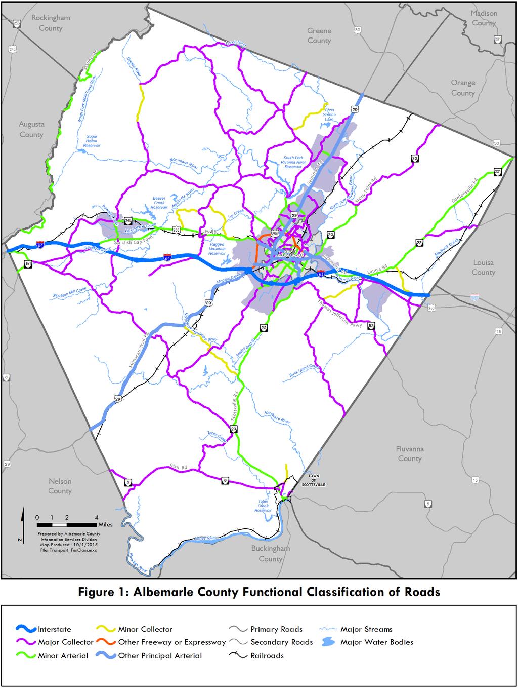
3 VISION: Albemarle County envisions a community with abundant natural, rural, historic, and scenic resources healthy ecosystems active and vibrant development areas a physical environment that supports healthy lifestyles a thriving economy and exceptional educational opportunity for present and future residents. Relationship to the Vision A strong economy and attractive and vibrant communities require good transportation systems. Investment in roads in the Development Areas enhances opportunities for moving goods and people. Constructing sidewalks allows people to walk to work and home again. Bike paths and bike lanes make bicycling an easy alternative to driving. These transportation elements also improve opportunities for children and teachers to walk and bike to school. By investing in sidewalks, bikeways, transit, and interconnected streets in the Development Areas, true mixed- use development can occur, making the Development Areas vibrant and attractive. Maintaining rural roads as rural travelways helps retain the County s rural heritage and scenic beauty and enhance farm to market opportunities. Transportation Introduction Transportation is one of the most important services provided by government. Not only does the transportation system provide for the mobility of people and goods, it also influences growth patterns by providing access to land. Transportation links people to their jobs, schools, shopping, community activities, and entertainment. The County strives to create an efficient and affordable transportation system offering travel choices that are functional and that will minimize harm to the community and natural environment. The purpose of the Transportation Chapter is to provide a plan that ensures the County s transportation system and infrastructure needs are accommodated and coordinated with the Development Areas and Rural Area throughout the County. This Chapter describes Albemarle s existing transportation network, presents the results of past transportation planning efforts, and sets forth the County s transportation goals, needs, and priorities for the next 20 years. The Transportation Chapter also helps inform residents and employers of Albemarle County s approach to addressing mobility needs, and how the future transportation system can affect the community. Transportation s Relationship to Land Use and Other Localities There is a distinct and mutually dependent relationship between transportation and land use. Land use decisions, such as development density and location influence regional travel patterns. The degree of access provided by the transportation system can, in turn, influence land use and development trends. For example, a connected system of streets with higher residential densities and a mix of land uses can help facilitate travel by foot, bicycle, and public transit, in addition to the automobile. More dispersed land development means that access is limited to cars and trucks, which can reduce the viability of other travel modes. In addition, transportation policy determines how people get from home to work, the amount of time spent commuting, and the types and degrees of choices available for getting from one place to another. The choices made about land use, including building design and orientation, all have an effect on transportation use and the quality of life. There is a regional context to transportation issues that extends beyond local interest. While land use plans and decisions are made in the context of governmental boundaries, transportation needs and networks cross 10.3
4 those jurisdictional boundaries. Careful coordination of transportation planning with land use planning at the State, regional, and local level is essential, and is why the County participates in regional transportation planning. Streets and Roads in Albemarle County Public streets and private streets are present in both the County s Rural Area and Development Areas. Private streets are typically maintained by owners associations or by the owners of the property in which the right-of-way exists. The Virginia Department of Transportation (VDOT) maintains all public streets and roads that have been accepted into their system for maintenance. Figure 1 shows public streets and roads in the County by functional classification. Functional classification is discussed in Objective 5. Transportation Plans and Acronyms In Virginia, local transportation planning has a strong relationship with regional, State and federal transportation planning. At each of these levels, there is a transportation plan and planning organization, as well as different service providers who use acronyms. A list of acronyms and their meanings is provided in the Reference Documents. Specific plans adopted by Albemarle County are found in the Appendix to this Chapter. Transportation System Challenges and Opportunities Albemarle County s transportation network is an important economic driver for the regional economy. Dispersed development patterns have helped promote a transportation network that is focused primarily on the automobile. In the past, a more abundant supply of cheap land and fuel encouraged development patterns that have become hard to sustain. Today and in the future, the local transportation system faces the challenges of finding adequate revenue, dealing with higher energy prices, accommodating future population and employment growth, and maintaining an aging system of transportation infrastructure. The continued coordination of land use and transportation affords opportunities to accommodate job and population growth more effectively. Concentrating growth in the Development Areas can increase the efficiency and affordability of public infrastructure, including the transportation system. Focused growth should decrease the need for new and improved transportation facilities and infrastructure outside of Development Areas, thereby making more funding available to maintain the existing system. Development Areas with a multimodal transportation system should improve the quality of life for County residents and the County s economic competitiveness within the region and the State. 10.4
5 10.5
6 Page intentionally left blank. 10.6
7 Objective 1: Continue to participate fully in State, regional, and local transportation planning efforts. The County s transportation plan is made up of several key documents. The longer range planning documents are the regional Long Range Transportation Plan (LRTP), the regional Rural Long Range Plan (RLRP), and the Development Area Master Plans. More immediate plans, tasks, and projects, are contained in the State Secondary Six-Year Plan, the Transportation Improvement Program, and the County s Six Year Improvements Program. Information on these plans and programs is found in the Appendix. The Appendix also contains a list of transportation projects, and costs estimates for improvements shown in the plans. All of the County s transportation planning activities have a relationship to the larger community, the region and State because no locality s transportation system operates in a vacuum. Transportation is part of an overall interconnected network, and changes in one part of the network affect the operation of other parts of the network. In addition, most transportation improvements in Albemarle County are dependent on state and federal funds. Therefore, regional coordination and cooperation is essential when planning strategies and improvements for transportation. Transportation planning and policy development occurs at the federal, State, regional, and local level. Federal transportation policy is implemented by the Virginia Department of Transportation (VDOT) and Metropolitan Planning Organizations (MPOs), among others. The U.S. Department of Transportation requires state DOTs, like VDOT, and regional MPOs to develop long-range transportation plans as well as short-range transportation improvement programs (TIPs) in order to qualify for the formula-allocated federal funds, that constitute a major portion of the Commonwealth s transportation budget. The plans must address a variety of policy factors such as environmental preservation, economic development, and community quality of life. Transportation also has an impact on air and water quality. Preservation and improvement of the region s air quality is addressed in the Natural Resources Chapter. A detailed table of applicable federal, State and local transportation planning documents can be found in the Transportation Reference Documents. Livability Project Charlottesville and Albemarle County will continue to promote regional multimodal and accessible transportation options by coordinating transportation planning between Charlottesville, Albemarle County, and the University of Virginia through the Metropolitan Planning Organization by: To do this, the County should: Store transportation data in the same format. Coordinate collection of transportation data to facilitate sharing information among Charlottesville, Albemarle County, the University of Virginia, and the Metropolitan Planning Organization. Increase and expand transit network efficiency and use. Coordinate building the sidewalk network across City-County boundaries and addressing barriers to pedestrian connectivity. Provide community education regarding transportation options. Collaborate to strengthen intrastate and interstate rail and air transportation opportunities. Coordinate to provide and enhance multi-modal connections between employment centers and areas of high residential density. Create dedicated bike-pedestrian connections across physical barriers within the community for: o Rivanna River o Route 250 East and West o Interstate 64 o Railroad network o City and VDOT system connection o Route
8 Strategy 1a: Continue to maintain compliance and ensure coordination of local transportation objectives and strategies with Statewide transportation plans, such as Virginia s Long-Range Multimodal Transportation Plan (VTrans2035) and the 2035 Virginia Surface Transportation Plan (2035 VSTP). Virginia law requires that a multimodal long-range transportation plan be developed and regularly updated to assess transportation needs and assign priorities on a statewide basis. The County works closely with State transportation planning officials to ensure the County s compliance with State transportation plans. State law requires that the County provide VDOT a copy of the Transportation Chapter of the Comprehensive Plan in draft form before it is adopted and a final copy after the Plan is adopted. V DOT reviews the Transportation Chapter to ensure it is consistent with State transportation plans and priorities. VTrans2035 is Virginia's long-range multimodal transportation plan. VTrans2035 establishes the policy framework for the recommendations found in the 2035 Virginia Surface Transportation Plan (VSTP). The latest update of VTrans2035 is the VTrans2035 Update completed in The 2035 VSTP builds on the priorities of VTrans2035 with specific recommendations for surface transportation modes such as highway, transit, rail, and freight. Broader, policy-level recommendations are provided for bicycle and pedestrian modes. Albemarle County is in the Blue Ridge Region, as defined in the VSTP Plan. Corridors of Statewide Significance (CoSS) are multimodal connections between main activity centers in the State. VTrans2035 has identified twelve Corridors of Statewide Significance throughout the State. CoSS provide a statewide multimodal perspective to guide localities in land use and transportation planning. Local governments are required to include these corridors in their Comprehensive Plans. The extent to which a locality protects the functionality of the corridor is considered as part of the State transportation funding process. The State desires to protect the transportation facilities in these corridors because they ensure mobility and long distance travel. These corridors are important because they: Involve multiple modes (highway, rail, inter regional transit, airport, water port) or represent a freight corridor that extends beyond an individual region; Connect regions, states, and major activity centers; and Provide a unique statewide function or address statewide goals. The VTrans2035 Update provides three classifications for CoSS: National Corridors (e.g.,. the I-95 Corridor); Commerce and Mobility Corridors (e.g. I-64, the East-West Corridor); and Statewide Corridors (e.g., Route 29, the Seminole Corridor). The first tier, National Corridors, includes routes that support mobility for nationwide travel and freight movement, connecting to states along Virginia s borders: Tennessee, North Carolina, West Virginia, Maryland, and Washington, D.C. The second tier, Commerce and Mobility Corridors, provides essential connections within the State between the economic drivers of Dulles International Airport and the coastal and inland ports. The remaining statewide Corridors support mobility within the Commonwealth. 10.8
: This corridor runs east to west throughout the State, connecting Hampton Roads to Richmond, Charlottesville, I-81, and West Virginia.")
9 Two statewide CoSS have been identified in Albemarle County: Figure 2: Virginia Corridors of Statewide Significance (CoSS) Source: Adapted from VTRANS 2035 Update, February 2013 East-West Corridor- I-64 (Circle C in Figure 2): This corridor runs east to west throughout the State, connecting Hampton Roads to Richmond, Charlottesville, I-81, and West Virginia. Parallel highway facilities to Interstate 64 include U.S. Highway 250 and U.S. Highway 60. Auxiliary facilities include I- 664, I-564, I-264, and I-464, all located in the Hampton Roads region. There are multiple transit options, mostly in the Richmond and Hampton Roads regions, and there are CSX rail lines along much of the corridor. The East-West Corridor provides the only interstate access to the Port of Virginia, and it provides access to multiple airports with commercial service in the Hampton Roads, Richmond, and Charlottesville regions. The East-West Corridor is identified as a Commerce and Mobility Corridor in the VTrans 2035 Update. Seminole Corridor Rt. 29 (Circle I in Figure 2): This corridor connects the Northern Virginia region to Charlottesville, Lynchburg, and Danville, operating as a parallel option between I-95 and I-81. It runs parallel to the Bull Run Corridor within Northern Virginia, and there are multiple transit options in the Northern Virginia region. In addition, there are Norfolk Southern Crescent Corridor rail lines along the entire corridor, which also provide passenger rail service. There are multiple general aviation and reliever airport facilities along the corridor, too. The Seminole Corridor is identified as a Statewide Corridor in the VTrans 2035 Update. Passenger and freight rail improvements are planned for the south to north rail corridor, as are improvements to existing roadways and transit improvements with the East-West CoSS. The State is expected to complete Corridor Master Plans (CMPs) for each CoSS over the next several years. In 10.9
10 2010 and 2011 a draft CMP was prepared for the Seminole Corridor. The CoSS master plans are planned to focus on the VTrans goals in each corridor, with differences in emphasis depending on the type of corridor. For example, a CoSS that does not include limited access highways should have a particular emphasis on balancing statewide mobility with multimodal accessibility to regional economic centers. Strategy 1b: Continue to recognize the Charlottesville-Albemarle Metropolitan Planning Organization (CA-MPO) as the transportation planning body for the region's MPO Area. In order to ensure that current and future federal transportation expenditures are based on the continuing, cooperative and comprehensive (3-C) planning process, in use since the early 1970s, federal legislation has required the formation of a Metropolitan Planning Organization (MPO) for any urbanized area with a population greater than 50,000. An MPO is a transportation policy-making body made up of representatives from local government and transportation agencies with authority and responsibility in metropolitan planning areas. A Metropolitan Planning Area can include the areas expected to become urbanized within the next 20 years. Federal funding for transportation projects comes from the Federal Highway Administration (FHWA) and the Federal Transit Administration (FTA) and is channeled through the MPO. For regional transportation planning purposes, the Charlottesville-Albemarle region consists of two geographic areas: urbanized and non-urbanized. In order to meet federal requirements regarding urbanized areas with a population exceeding 50,000, Albemarle County and the City of Charlottesville established the Charlottesville-Albemarle (CA MPO) in 1982 through a Memorandum of Understanding (MOU) signed by the Thomas Jefferson Planning District Commission (TJPDC), JAUNT (formerly the Jefferson Area UNited Transportation;, now a public corporation owned by the local governments as JAUNT, Inc.), VDOT, and the two localities. The MOU was last updated in The CA MPO is the primary regional planning body responsible for transportation planning in the area it covers. The CA-MPO provides a forum for transportation decision-making among the City, County, UVA, JAUNT, CAT, DRPT, and VDOT officials. The CA-MPO area includes the City of Charlottesville and the portion of Albemarle County that is either urban or anticipated to increase to urban density during the next 20-year period. In 2013, the CA- MPO boundaries were updated and expanded to be more consistent with 2010 census data. These new boundaries were approved in early The CA-MPO boundary does not have a direct impact on development of County regulations. As a federal requirement, the CA-MPO area is tied to federal transportation funding, and projects in the MPO s Long Range Transportation Plan are expected to be built in the next 20 years. The CA-MPO, with the assistance of designated staff, is responsible to: Plan for the coordinated delivery of transportation services by public and private providers. Identify and recommend to the City of Charlottesville, Albemarle County, and UVA those administrative and operational activities that can be appropriately coordinated or centralized among service providers. Review all service proposals and develop a procedure for identifying public transportation service demand and identify appropriate service providers. A map of the geography of the CA-MPO area appears in Figure 3. The non-urbanized area is not part of the CA-MPO: planning activities for the non-urbanized area mainly occur through the Rural 10.10
 The policy making body of the CA- MPO is its Board, which consists of five")
11 Transportation Planning Program of the TJPDC. The TJPDC prepares the Rural Long Range Plan (RLRP) which complements the Long-Range Transportation Plan (LRTP) of the CA-MPO. Figure 3: Charlottesville-Albemarle Geography of the CA-MPO Area Source: TJPDC 2014 Unified Planning Work Program (UPWP) The policy making body of the CA- MPO is its Board, which consists of five voting members. The voting membership of the Policy Board is made up of two representatives from the City of Charlottesville and two representatives from the County of Albemarle. The County s two MPO members are from the County Board of Supervisors, who ensures that the projects and policies of the CA-MPO are reviewed by the County s governing body. The fifth representative is from VDOT. Nonvoting members include the Department of Rail and Public Transportation (DRPT), CAT, JAUNT, UVA, the Federal Highway Administration (FHWA), the Federal Aviation Administration (FAA), the Federal Transit Administration (FTA), and the Citizen s Transportation Advisory Committee (CTAC) formerly known as the Charlottesville-Albemarle Regional Transportation Citizen Advisory Committee (CHART). The CA-MPO is staffed by the TJPDC. Working in conjunction with partner and professional agencies, the staff collects, analyzes, evaluates and prepares materials for use by the Board and Committee Members at their regularly scheduled meetings, as well as any sub-committee meetings deemed necessary. Strategy 1c: Continue to participate in development and adoption of the LRTP for the CA-MPO area. The LRTP includes all desired transportation projects anticipated to receive federal funding through funding projections for the next 20 years as well as longer term vision projects. The LRTP must be fiscally-constrained, meaning the LRTP cannot propose projects that will require the expenditure of more funds than are reasonably expected to be received over the 20-year planning period. The LRTP is the lead document particularly for projects at a network level. The LRTP, along with the Comprehensive Plan, Master Plans (See Strategy 2a, which also identifies more local neighborhoodlevel transportation improvements) establishes the transportation recommendations for the Development Areas. The LRTP addresses all modes of travel, including roadways, travel demand management and public transit, pedestrian and bicycle access and facilities, rail, and air travel. The LRTP contains inventories, data, and analyses of the transportation system and makes recommendations for providing and maintaining an adequate transportation system. It is important to coordinate transportation 10.11
12 planning, including the sharing of data among all those individuals and organizations involved in regional and local transportation planning. Strategy 1d: Continue to support construction of projects adopted into the LRTP and the Transportation Improvement Program (TIP). As the lead document for transportation planning in the CA-MPO area, the LRTP provides a comprehensive approach to addressing transportation issues in Charlottesville and urban Albemarle. Its implementation takes place through the TIP. The TIP lists road and transit improvements approved for federal funding. The TIP is a financially constrained, short-term plan for projects that can be funded with expected revenues in the next three to five years. Projects funded in the TIP are required to be in the LRTP. Strategy 1e: Continue to recognize the TJPDC's rural planning function by taking formal action on rural transportation planning recommendations and reviewing the TJPDC's adopted studies and, where appropriate, consider adopting such studies into this Plan. The County is also involved in a regional transportation planning effort covering the rural areas of the County (outside the CA-MPO area) together with Fluvanna, Greene, Louisa, and Nelson Counties. The Rural Area Transportation Long Range Plan process complements MPO-level planning efforts and establishes a regional transportation planning process to address broader regional and rural issues. This Plan identifies a larger transportation system framework within the Thomas Jefferson Planning District area. The Plan is generally reflective of and consistent with County goals for transportation planning for the Rural Area. The major transportation goals for Albemarle County s Rural Area are to preserve rural character while improving safety and multimodal transportation choices. The County s policy is to retain rural roads in their current condition, focusing on road safety improvements, such as shoulders and guardrails, straightening curves, and increased regular maintenance, rather than paving and widening rural roads. Road improvements in the Rural Area should not encourage growth outside of the Development Areas, but they should provide access from farms to markets along strategic routes. Rural roads have multiple purposes and benefit from design that keeps drivers alert and encourage them to move at the appropriate speeds to accommodate slower moving farm equipment, bicyclists, people checking the mail, or children walking to a bus stop. The County has adopted a policy to address private citizens who wish to use their own resources to pave public roads. A copy of this policy may be found in the Transportation Appendix. Objective 2: Continue to plan transportation improvements in accordance with the County s Growth Management Policy. The County s Growth Management Policy provides that growth should be concentrated in the Development Areas where the County provides the highest level of investment in infrastructure and services. Together with the Neighborhood Model design principles, the Growth Management Policy lays the groundwork for a multimodal transportation network. These strategies help to preserve farms, forests, and fields in the Rural Area and improve quality of life in the Development Areas. In addition, a multimodal transportation system provides an efficient use of public dollars, helps conserve energy, provides more transportation choice, reduces congestion and improves quality of life for residents among other benefits
13 Strategy 2a: Continue to implement the transportation planning recommendations in the County s adopted Master Plans. The County s Growth Management Policy is strongly reflected in the Development Area Master Plans which show where growth is expected and recommend land use and infrastructure necessary to support that growth. The Master Plans include recommended improvements for streets, greenways, trails, sidewalks, streetscape, bicycle lanes, bikeways, and streetscape in each Development Area. As further explained in the discussion on County travel modes, roadways in the Development Areas are expected to be complete streets which are streets built to accommodate other modes of travel in addition to vehicles. Transportation goals, objectives, and strategies in the Master Plans are consistent with the LRTP. In addition, they include specific recommendations for improvements serving a more local function, such as interconnections between neighborhoods or interconnections from neighborhoods to employment areas. Although locally important road improvements may not be eligible for State or federal funding, they should be constructed through other ways, such as the County s Capital Improvements Program (CIP) or as proffered improvements that support new developments. Strategy 2b: Continue to work closely with State, regional and local partners to ensure that transportation improvements meet Albemarle County Comprehensive Plan goals and priorities as annually reflected in VDOT s Six Year Improvement Program (SYIP) and Secondary Six Year Plan (SSYP). Funding for rail, public transit and highways (generally primary roadways and interstates) is allocated through VDOT s annual Six Year Improvement Program (SYIP). The SYIP requests that the Commonwealth Transportation Board (CTB), the political body that works with VDOT, approve funding for prioritized projects proposed for construction, development, or funding over the next six fiscal years. The total list of projects exceeds that which can be completed during the six year time horizon of the plan. All individual interstate and primary road projects in Albemarle County compete for funding with other localities in VDOT s Culpeper District with funding being allocated to each VDOT construction district rather than individual localities. The County has significantly more control over project priorities on the Secondary System than it does on the Primary System. In Albemarle County, transportation projects are selected to be included in the SYIP if they are included in the Charlottesville-Albemarle MPO s regional TIP. State law requires the development and publication of a separate program for each locality s secondary road system. Funding for secondary roadways, bridges, and culverts is planned through VDOT s annual Secondary Six-Year Plan (SSYP). The County provides VDOT with a priority list of Secondary Road improvements that establishes priorities for road improvements in the State s Secondary Road system. VDOT s SSYP is based on the County s priority list and reflects available State road funding allocated to the County. The County s priority list is reviewed annually by the Board of Supervisors and based on the direction provided by the Board regarding projects to be funded, VDOT revises the SSYP. As development occurs, local roadways are built by private developers under the direction of local governments, like Albemarle County, and later turned over to VDOT for long-term maintenance. In other cases, private development projects approved by the County can generate traffic levels that trigger a need for VDOT to program improvements to State-owned roadways
14 Strategy 2c: Continue to work closely with State, regional and local partners to ensure that roadway structures (bridges and culverts) with low sufficiency ratings are annually prioritized in the SSYP for funding, repair and/or replacement. Roadways, bridges, and culverts with low sufficiency ratings are facilities that are in need or soon to be in need of replacement. VDOT is responsible for the inventory and inspection of over 20,000 bridges and culverts along the public road system across the State. While new bridges and culverts have a design lifespan of 75 years, the majority of these structures were designed for a service life of 50 years. Approximately 60% statewide are now 40 years or older. In the Culpeper VDOT Construction District, 450 of the 1,693 bridges and culverts are located in Albemarle County. Of these, approximately 164 bridges and culverts (36% of the total) are at the end of their design lifespan and have not been reconstructed in the last 50 years. Planning and funding are needed to ensure that replacement bridges and culverts are not left to deteriorate and cause safety issues. Objective 3: Continue to improve, promote, and provide regional multimodal and accessible transportation options. Multimodal transportation planning in Virginia has continued to gain in importance over the years. The State defines multimodal transportation planning as: A coordinated system of roads, rails, ports, transit, bicycle, pedestrian and aviation resources that provides integrated and efficient options that meet citizen, visitor and business transportation needs. In addition to being a State priority, multimodal transportation has been a hallmark of the Charlottesville- Albemarle long-range transportation plan, including traffic demand management techniques. It is also a key principle in the Neighborhood Model, as discussed in the Land Use for Development Areas Chapter. Providing regional multimodal transportation options featured prominently in the joint City-County policy recommendations in the Livable Communities Planning Project. Albemarle County strives to promote transit-friendly, walkable, mixed-use communities that are served by multiple transportation modes. A connected, mixed-used community can reduce the number of vehicle miles traveled (VMT) and, thereby, improve citizens health by reducing vehicle emissions. A reduction in VMT improves air quality by reducing the amount of greenhouse gases emitted by vehicles. Interconnected streets and alternatives to vehicular travel, like mass transit, walking, or biking also have the potential to improve or mitigate air quality problems by reducing VMT. Multimodalism provides for: Cost-Efficient Use of Public Dollars which benefits travelers by moving people (not cars) while expending the same amount of money and optimizing the use of existing facilities instead of building new ones. Energy Conservation by reducing emissions through fewer and shorter vehicle trips. More Transportation Choices by providing alternate modes, times, locations, and route choices for travel
15 Mobility and Opportunity Equity by meeting transportation needs of low income, disabled, and other minority populations and providing more opportunities for getting to work, making connections, and career advancement. Public Health by creating a safer environment for walkers and cyclists, with fewer crashes and lower fatality rates, supporting active lifestyles through more opportunities for walking, and providing more access to a wider range of goods and services. Economic Vitality by providing greater accessibility for existing and future workforces, attracting businesses through more multimodal transportation choices for employees, and increasing property values by making places more accessible. Reducing time in commutes time equals money. Reduced Congestion by giving more modal choices reducing overall congestion and providing greater redundancy in network choices through other modes. Quality of Life by designing streets as places to spur social interaction, promoting pride in neighborhoods, spurring more eyes on the street for crime reduction, and facilitating a greater sense of community through more accessible places and corridors. In addition to the objectives and strategies found in each local travel mode, the County should use the following strategies to promote multimodal and accessible transportation options at a regional level. These strategies were developed and recommended by the City and County Planning Commissions in their joint policy recommendations from the One Community project. Strategy 3a: Continue to coordinate multimodal transportation planning among the City of Charlottesville, Albemarle County, and UVA. As mentioned earlier, for many years, the CA-MPO, TJPDC and County have engaged in planning activities through the LRTP Transportation Planning among the City, the County and UVA has also involved the Planning and Coordination Council (PACC). For example, the 1994 Ivy Road Design Study was funded by all three entities and recommended pedestrian, transit, bicycle, and streetscape improvements. Strategy 3b: Increase and expand transit network efficiency and use throughout the region. An efficient transit network is a hallmark of a well-run transportation system. In order to have an efficient transit system throughout the Charlottesville and Albemarle region, transit planning must occur at a regional level, not solely focused on one locality or the other. Recommendations relating to transit are found later in this Chapter. Strategy 3c: Create dedicated bicycle-pedestrian connections across physical barriers within the community. There are many physical barriers that stand in the way of a good bicycle and pedestrian network. These barriers include: The Rivanna River at Pantops; The multi-lane travelways of Route 250 East and West; Interstate 64; Railroad tracks throughout the City and County; City and VDOT road system connection; and 10.15
16 Multiple travel lanes on Route 29 North. The City and County should strive to coordinate better pedestrian connectivity across City and County boundaries. This is particularly important when discussing pedestrian connectivity across physical barriers. The Livability project recognized this critical need and made it one of the top two priorities for the City and County to work together on. Strategy 3d: Continue to provide community education about multimodal transportation options. A regional multimodal system is a better way to connect people and places. Educating the public about multimodal transportation options helps the public understand the relationship among transportation, land use and air and water quality. Additional information on the benefits of multimodal transportation options can also help inform the public about incentives and benefits that could make it advantageous to use alternative forms of transportation. Strategy 3e: Collaborate to strengthen intrastate and interstate rail and air transportation opportunities. Air and rail transportation work together to serve the region s freight and passenger travel needs. The City and County Planning Commissions agreed that opportunities for improving rail and air transportation should be jointly pursued since improvement to both modes can benefit City and County businesses and residents. Strategy 3f: Coordinate with developers and the City to provide and enhance multimodal connections between employment centers and areas of high residential density. Connecting areas of high residential density with employment centers can help increase local transit ridership and other alternative forms of transportation. Increased transit ridership can help make transit services more economical to operate and reduce the automobile vehicle miles traveled, which helps improve air quality and reduce traffic. The County should support the expansion of transit service to areas of high employment and population growth. Objective 4: Strengthen efforts to complete a local transportation system that includes access to pedestrian and bicycle facilities. A complete local transportation system includes transit, sidewalks, pathways, bikeways, street lights in developed areas, and safe and convenient crosswalks. Pedestrian and bicycle access to these features is an important aspect of the County s overall multimodal transportation system. Pedestrian and bicycle access improvements can complement and enhance the mass transportation system by improving access to bus stops and places of economic activity. Providing an effective pedestrian and bicycle system can enhance the sense of community within developed or developing areas. Pedestrian and bicycle facilities can connect communities and encourage interaction within the area. The County has several different types of pedestrian and bicycle facilities. These facilities may be part of VDOT s system or may be privately owned and maintained. Currently, there are on-road bike lanes on Hydraulic Road, Rio Road, Greenbrier Drive, Hillsdale Drive, Northfield Road, and Carrsbrook Drive, with off-road facilities on 5th Street/Old Lynchburg Road, and Fontaine Avenue
17 The County s Urban neighborhoods have the majority of the locality s pedestrian facilities, which include sidewalks along Route 29 North, Rio Road, and Hydraulic Road, as well as some along neighborhood streets and trails. Asphalt sidewalk facilities, separate from but adjacent to roadways, exist along Georgetown Road, Fontaine Avenue, Avon Street, 5th Street Extended, and Old Lynchburg Road. Sidewalks also exist in the Town of Scottsville and in the Community of Crozet. Strategy 4a: Continue to include bicycle lanes, bikeways, sidewalks, and crosswalks within new developments in the Development Areas. Provide amenities such as bike racks in employment and shopping areas. Walking and biking connections are important parts of to a multimodal transportation network. Such connections are supported by Development Areas Master Plans and other regional long-range planning documents, including the MPO Long Range Transportation Plan, the Jefferson Area Bicycle, Pedestrian, and Greenways Plan, and the TJPDC Rural Long Range Transportation Plan. Master Plans often identify centers in Development Areas that serve as destinations for residents. The Master Plans show how bicycle and pedestrian accommodations can connect centers and other destination points. Bicycle and pedestrian facilities benefit the County in multiple ways. They can remove barriers to mobility, broaden travel options for non-drivers, reduce conflicts between motorists and other road users, reduce automobile traffic, increase recreational activity and exercise, encourage non-motorized tourism, accommodate people with disabilities more effectively, and help create more livable communities. Improved pedestrian and cycling conditions can benefit everyone in the community regardless of how much they use non-motorized travel modes. It is important to provide amenities to encourage bicycle and pedestrian travel. Methods for securing bicycles at destinations should be provided in developments. If possible, shower and locker facilities should be provided at destinations to facilitate bike travel for commuting purposes. Bicycling provides an alternative mode of transportation to vehicular travel. Bicycle travel is accommodated by on-road bicycle lanes that share lanes with vehicular traffic, and off-road paths and trails. Bicycles and pedestrians can share multipurpose paths; however, bicyclists should not travel on sidewalks for the safety of pedestrians and bicyclists. In addition to bicycle lanes and paths maintained by the State, a segment of the U.S. Bicycle Route System that extends from Virginia to Oregon is located in Albemarle County. Route 76 is one of two original U.S. Bicycle Routes. Strategy 4b: Improve funding for an ongoing walkway, bicycle, and greenway construction fund in the Capital Improvements Program (CIP). Use all possible funding sources for the construction of walkways and bicycle facilities. Public sidewalks are maintained by VDOT and are located within public rights of way parallel to a roadway. Sidewalks are intended for Development Areas only and are required on new streets in the Development Areas. Urban streets with curb, gutter, and a tree lawn located between the back of the curb and the sidewalk are expected. Sidewalks are most typically constructed by the private sector as a part of development projects, but they are also built by the County or State in conjunction with public projects. VDOT maintains sidewalks on State routes that have been built to VDOT s subdivision street standards. On State routes not built to VDOT standards, VDOT determines maintenance eligibility after study by the County and local VDOT Resident Engineer. Funding for public sidewalks typically comes from state and federal programs. Private sidewalks are expected within the developments of non-residential, multi-family, and mixed use developments in the 10.17
18 Development Areas. Some privately owned and maintained sidewalks are located adjacent to the right-of-way in single-family developments; however, this is the exception rather than the rule. All privately owned sidewalks are built by the private sector and are maintained by the development owner or an owners association. Improved local funding is needed to continue buildout of the planned infrastructure for the Development Areas. It is important to complete planned infrastructure improvements such as sidewalks, bikeways, and greenways in order to improve the quality of life in these areas. Improving the quality of life can, in turn, attract the desired density to the area. Strategy 4c: Continue to implement recommendations for future bicycle and pedestrian projects as identified in adopted local and regional transportation plans and studies and Development Areas Master Plans. In 2004, the TJPDC created the Jefferson Area Bicycle, Pedestrian, and Greenways Plan which contains recommendations for sidewalks, bicycle improvements, and proposed greenways for the City of Charlottesville, UVA, and Albemarle County. These improvements can also be found in Development Area Master Plans, the LRTP, and the RLRTP. As updates to the regional bicycle, pedestrian, and greenways plan are adopted, they will help guide future CIP projects, volunteer activities, and proffers from developers. When built, these facilities will help to improve mobility in the community and the region. Strategy 4d: Study and evaluate methods to ensure long-term maintenance of street trees within the tree lawn areas of road right-of-ways. The appearance of Albemarle County s roads and streets is often enhanced with landscape features such as trees and shrubs. Street trees are expected in the Development Areas to help enhance the streetscape and create a more inviting environment for walkers and bicyclists. Street trees have been planted in many of Albemarle County s newer developments in the Development Areas. VDOT does not maintain street trees within public road right-of-ways and most often a development s owner s association is responsible for maintaining street trees. Most of the trees have not reached maturity where they offer shade and canopy. As they mature, maintenance and replacement of street trees will be needed. A plan for ensuring maintenance and replacement of street trees is needed to ensure that the streetscape is both attractive and safe for the long-term. Strategy 4e: Continue to use VDOT and railroad excess and/or abandoned right-of-way for multiuse trails. Trails and paths provide off road pedestrian access in both private and public developments. Multipurpose paths can accommodate cyclists, as well as pedestrians. Trails and paths are sometimes located within greenways and provide a recreational and transportation function. It can be difficult and costly to acquire new right-of-way for trails and greenways. Existing road right-of-ways that are not needed for their original purpose can and should be used for multi-use trails where they can create connections within the larger network. Railroad right-of-way may be available for other transportation uses; however, this type of use is not guaranteed and consent from owners or compensation may be needed. More information on off-road trails and paths can be found in the Parks and Recreation, Greenways, Blueways and Green Systems Chapter

19 Objective 5: Continue to preserve the functionality of the roadway systems in Albemarle County and plan for and implement access management strategies. Automobile travel is the primary transportation mode in the County and one of VDOT s main transportation roles is to assure that roads and streets function adequately to support the movement of vehicular traffic. VDOT organizes roads into three categories: primary, secondary, and urban. Streets in the urban category belong to municipalities. Roads in the primary and secondary category are in counties and in towns which do not maintain their own streets. There are 115 miles of primary roadways in the County, including: Route 29 Route 250 Route 20 Route 53 Route 231 Route 6 Route 22 Route 151 Route 240 All of these primary roads are designated as Entrance Corridor routes, providing access to the County's and contiguous localities historic districts and properties. Therefore, they are important not only for their transportation function, but also for their scenic and visual character. More information on Entrance Corridors and other scenic designations can be found in the Historic, Cultural and Scenic Resources Chapter. The majority of roads in Albemarle County are secondary roads. As of December 31, 2010, there were 870 miles of secondary roads in the County. Of these, 652 miles (75%) were hard-surfaced and 219 miles (25%) were unpaved rural roads. Figure 4: Functional Classification Diagram and Access Management Functional Classification of Roads Each public roads is functionally classified as an arterial, collector, or local street according to the type of service it is intended to provide and its operational characteristics. Figure 4 shows the relationship between travel speeds and classifications of roads. Arterial roads are large more heavily traveled roads and often thought of the main roads in an area. Collectors provide access to arterial roads, carry less traffic than arterials, and provide interconnections in the community. Local roads and streets are the least traveled thoroughfares and usually connect only to collectors. Many arterial roads are State primary roads, and some are collector roads. Secondary roads are mostly local and collector roads. Generally, routes within the Primary System are numbered under 600 and routes within the secondary system are numbered 600 and above. Source: Albemarle County 2013 A roadway s functional classification defines the role a given facility plays in the overall transportation network. The functional classification also dictates how many access points to residential and non-residential development may be provided. Functional classifications provide a guideline for managing a roadway s through-traffic versus the provision of access to adjacent property
20 In Albemarle County, functional classifications for local roadways that follow the Neighborhood Model was a concept discussed as part of the 2004 Crozet Master Plan and the 2011 Places29 Master Plan. The concept includes additional street types that are of a neighborhood scale, with reduced lane widths and emphasis on slower speeds. These street types complement existing federal functional classification used by VDOT. More information on Neighborhood Model street types may be found in the recommended guidelines for Setbacks, Sidewalks, and Urban Streets in the Appendix. Access Management Access management is a planning tool that provides for more efficient roadways by consolidating or limiting driveways, entrances, and median openings along collector and arterial roads. It also enhances the functional capacity of intersections of roadways. Figure 4 also illustrates how traffic volumes and land uses are related. Roadways like arterials favor through-movement of traffic over direct access to property. Limiting property access on higher volume roads requires fewer access points or access from lower volume roads such as local or collector roads that intersect with the higher volume roads. Access management regulations govern access and intersection spacing along all State-maintained roads. Access points are locations for potential vehicle conflicts as motorists enter, maneuver, and exit the roadway. Access management maximizes the effectiveness and safety of the roadway system as it relates to providing access to land adjacent to the roadway. Important benefits of access management include: Safety - The implementation of good access management practices on a corridor can reduce vehicle crashes by 50% or more. Mobility - Spacing traffic signals at appropriate distances permits signals to be coordinated for optimized operation. Optimal signal spacing can reduce the need to increase a roadway s capacity by widening intersections and corridors. Reducing conflicts with non-motorized modes - Controlling the number and width of driveways reduces areas of exposure for pedestrians and bicyclists along a roadway. Aesthetics - By providing raised medians and reducing the width of driveways, more room is available for landscaped beds or decorative hardscape surfaces. Access management is appropriate for all roadway types, but the techniques employed depend upon roadway functional classification and context area. Roadway function - The highest level of access management applies to high-speed regional and community arterial roadways. Land use context - Greater access control is appropriate for higher order roadways in suburban areas, where operating speeds are highest. Conversely, a higher concentration of driveways is normally found in urban areas. However, the number of driveways should be moderated on main streets to reduce conflicts between motorists and pedestrians or bicyclists. As Albemarle County continues to develop, access management techniques are increasingly important to maintain roadway efficiency and traffic safety because road improvements and expansions are very expensive. When access proliferates excessively, highways lose their intended function (i.e., quicker mobility) and capacity causing an increase in accidents. Arterial roads, originally designed to connect communities, instead become congested with local traffic, leading to delays and safety problems not only for motorized traffic but also for pedestrians and other non-motorized traffic
21 Strategy 5a: As Development Areas Master Plans are updated, address access management strategies. When transportation studies or projects are planned in the Rural Area, ensure that access management strategies are addressed. In 2008 and 2009, VDOT adopted new access management regulations. Since 2009, VDOT has been implementing access management standards for arterials, collectors, and local roads. Spacing standards for signals, intersections, and entrances were reduced for certain situations in An Access Management Strategy Report was developed and adopted as part of the Places29 Master Plan and can be found in the Appendix. The Report provides a series of strategies for managing access along Rt. 29 in Charlottesville and Albemarle. The strategies of this study were incorporated into the objectives and strategies found in the Transportation Section of the Places 29 Master Plan. The Places 29 Access Management Strategy Report is the only report currently adopted as part of the Comprehensive Plan. Objective 6: Continue to provide safe, effective, and improved urban roads in the Development Areas while recognizing that multimodal opportunities help to improve road functions. Roads in the Development Areas are expected to be complete streets that can accommodate and encourage pedestrians, bicyclists, and transit, in addition to cars. Complete streets make it easier to cross the street, walk to shops, and bicycle to work. They allow buses to run on time and make it safe for people to walk to and from bus stops, among other things. Strategy 6a: Use and continue to implement Development Areas transportation planning recommendations as found in adopted local transportation planning documents and studies. New development and redevelopment in the Development Areas rely on the recommendations of the Neighborhood Model which expects a more urban than suburban form of development. A detailed discussion of the Neighborhood Model can be found in the Development Areas Chapter and the Neighborhood Model Design Guidance found in the Appendix. Other local transportation planning documents include the Development Areas Master Plans and the Recommended Guidelines for Setbacks, Sidewalks, and Urban Streets, all of which are in the Appendix. Strategy 6b: Standardize a process and method to complete the major road network in the Development Areas. Traditionally, most County roadway improvements have been limited to funding through VDOT s six year plan programs (SYIP and SSYP) for both primary and secondary roads. However, the County has made a more concerted effort to fund the development of locally important proposed roads and to work with the development community to encourage them to participate in developing these roads. Examples of these projects include the connection of Commonwealth Drive to Greenbrier Drive, the construction of Hillsdale Drive-Branchlands Boulevard, and the construction of Berkmar Drive Extended, in which the County and developers shared construction costs. While progress towards completing the network will be incremental, the County needs to have a process in place that makes it easier to identify, prioritize, and find funding for projects to complete the transportation network in the Development Areas
22 Objective 7: Continue to provide safe and effective transportation options while preserving the character of the Rural Area. With their scenic and visual character, roadways in the Rural Area serve as gateways for people traveling to visit the County s rural resources, such as historic sites or wineries. Greater traffic volume and traffic safety on these roads is a concern of residents and drivers. Roadways in the Rural Area are shared by pedestrians, equestrians, farm vehicles, bicyclists, and automobiles. Strategy 7a: In the Rural Area, continue to focus on safety improvements rather than on paving and widening rural roads. Consider rural traffic calming techniques to reduce speeding. Adhere to and implement the recommendations found in the Rural Road Design Standards. The County expects that roads in the Rural Area will have a rural look and feel. Improvements to rural roadways that improve safety are encouraged, but, they should not be built or upgraded to increase vehicle speed, by adding lanes. Tactile improvements such as changing the texture on rural area roads from a smooth surface to a courser material can increase driver awareness of speed. Improvements such as making bridges visually distinctive would call attention to a stream crossing by providing a visual cue to slow down. Operational changes, such as adding roundabouts to rural intersections can improve safety by bringing vehicle speeds down, reducing crashes and moving traffic better than traffic signals. Roundabouts could also serve as a unique gateway to a rural area. More information on traffic calming and safety improvements on rural roads can be found in the Reference Documents. Strategy 7b: Except for agricultural and forestal purposes, continue to limit construction of new roads in the Rural Area, especially where road building would have an impact on or fragment natural habitats. Road projects can negatively impact existing natural resources if not constructed carefully. Widening rural roads without appropriate drainage measures can increase soil runoff. Stream crossings can erode stream banks and culverts can interfere with aquatic life. Because natural resource protection is very important in the Rural Area, new road projects and road improvement projects should include measures that avoid degrading habitats or actively improve them. For example, if a new road must cross a migration corridor, wildlife tunnels can be designed and built to assist in habitat connectivity which can help to reduce habitat fragmentation and protect biodiversity of species. Strategy 7c: Continue to pursue the Rural Rustic Roads Program as an alternative to the Pave-In-Place program for qualified roads that have been designated to be paved by the County. The Pave-In-Place program is a VDOT program designed to pave low-volume unpaved public roads. However, the Pave-in-Place program is typically used for secondary road projects that may require more intense improvements, such as drainage and slope improvements and acquisition of additional right-of-way for safety improvements. The Rural Rustic Roads (RRR) Program is a more environmentally friendly and less costly way to pave secondary roads than the Pave-In-Place Program. The RRR Program typically improves roadways (such as surfacing unpaved roads) between existing drainage ditches with very minor drainage and slope improvements, if any. The RRR program allows for safety improvements to be completed on rural roadways in a more cost-effective and timely manner without the need for disturbing significant amounts of land in the Rural Area
23 Strategy 7d: Continue to provide and enhance rural transit opportunities for elderly and disabled residents. Enhance ridesharing opportunities. Although the County s Growth management Policy is intended to provide improvements and services to the Development Areas, there continue to be residents in the Rural Area who need to travel to the Development Area for services. Expanding the use of transportation alternatives for residents with the most need in the Rural Area can help reduce traffic and vehicles miles traveled. For rural residents, such alternatives are critical for those that do not have reliable personal transportation. Improving transportation alternatives for Rural Area residents can include expanding para-transit services offered by JAUNT and creating more Park and Ride lots to encourage ride sharing to employment and population centers. Objective 8: Continue to improve public transit service. Public transportation in the Development Areas is provided through three separate agencies: Charlottesville Area Transit (CAT), the University Transit Service (UTS), and JAUNT, Inc. These three agencies often collaborate to improve services within the region, but each has their own service responsibilities and goals. University of Virginia Transit Service (UTS) UTS offers transportation and charter services to students, employees, and visitors to UVA. It operates six fixed routes throughout the calendar year with a focus on the academic year. UTS has three types of service: full, holiday, and commuter. UTS and CAT share multiple stops where transfers can be made between the two systems. Commuter routes serve parking lots, while charter service provides spectator transport during special events. Charlottesville Area Transit (CAT) CAT provides public transportation in Charlottesville and the urban neighborhoods of Albemarle County. The County participates in funding County routes. CAT operates seven days a week with some evening service and very limited service on Sundays. Routes that provide service in the County include: Route 1, which provides service to Piedmont Virginia Community College; Route 3, which provides service to the County Office Building on 5 th Street Extended and Southwood Mobile Home Park; Route 5, which provides service to Walmart on Route 29 North; Route 7, which provides service to the Shops at Stonefield and Fashion Square Mall also on Route 29; Route 8, which also provides service to the Shops at Stonefield and Fashion Square Mall Route 9, which provides service to Fashion Square Mall from Greenbriar Drive and a small part of Rio Road; Route 10, which provides services to the Pantops area and Martha Jefferson Hospital on R 250 East; and Route 11, which provides service to CATEC, Fashion Square Mall, and neighborhoods in the Rio Road corridor
24 Figure 5 shows the CAT service system map which reflects the current routes. These routes will change over time. JAUNT, Inc. Paratransit Service The City of Charlottesville and Albemarle County jointly fund paratransit service through JAUNT. JAUNT is a regional public transportation system providing fixed-route and demand-response service to the general public, agency clients, the elderly, and people with disabilities throughout Central Virginia including existing communities in Albemarle s Rural Area. Other Transportation Providers County residents are also served by private taxi services and inner city bus services, such as Greyhound Bus Lines which has a bus station on West Main Street in Charlottesville. Strategy 8a: Continue to use the recommended improvements for public transit in local Development Areas Master Plans and regional transportation plans such as the Long Range Transportation Plan, the Transit Development Plan, and other studies to determine the location and timing for the provision of transit services. CAT completed a Transit Development Plan (TDP) for FY in The Virginia Department of Rail and Public Transportation (DPRT) require the TDP to identify public transit service and facility needs for six years and include public transit recommendations from the MPO Long Range Transportation Plan. At the request of the City, the TDP also included an extensive evaluation of the existing service characteristics and facility needs. Strategy 8b: Continue to provide public transit service hours at nights and on weekends on appropriate routes to improve ridership and service. Continue to provide service to the Rio Road area, including service to CATEC and the residential neighborhoods along Rio Road. CAT currently provides evening and weekend services (Saturday only) on several public transit routes that travel into the County. It is important to continue to provide bus service on night and weekends to serve people who work evening and weekend shifts. In addition, evening bus service allows those taking night education classes (such as at PVCC) to return home after classes end. Longer hours of operation increase ridership and ultimately make transit a more viable alternative. Strategy 8c: Expand transit service to the Hollymead Development Area, Cedar Hill Mobile Home Park, south of I-64 on Avon Street Extended, and Route 250 West. In March 2013, the City concluded the 2013 CAT Transit Study that built upon the efforts of the 2011 TDP. The 2013 study focused on identifying adjustments to existing fixed-route bus services by increasing ridership, improving service quality, and improving route efficiency. Some of the routes have been adjusted, a new route was added, but more services are needed in the future

25 Figure 5: 2015 Charlottesville Area Transit Bus Routes and System Source: Transit Schedule 10.25
University of Virginia Master Planning Committee November 17 th Charlottesville Albemarle Metropolitan Planning Organization
 University of Virginia Master Planning Committee November 17 th 2010 Charlottesville Albemarle Metropolitan Planning Organization 1 Who are we? What is an MPO A Metropolitan Planning Organization is a
CHAPTER 2. VISION, GOALS AND MTP FRAMEWORK
 CHAPTER 2. VISION, GOALS AND MTP FRAMEWORK MTP VISION In order to create a framework for the 2040 Metropolitan Transportation Plan (MTP), a vision statement was drafted by the Vision/Goals Committee and
Corridors of Statewide Significance: Introduction
 Virginia s Long-Range Multimodal Transportation Plan Corridors of Statewide Significance: Introduction Prepared for: Commonwealth Transportation Board Prepared by: Office of Intermodal Planning and Investment
PERFORMANCE-BASED PLANNING AND PROGRAMMING
 February 2017 performance-based planning and programming Boston Region MPO PERFORMANCE-BASED PLANNING AND PROGRAMMING WHAT IS PERFORMANCE-BASED PLANNING AND PROGRAMMING? Performance-based planning and
Chapter 3 - Goals, Objectives, & Strategies
 Chapter 3 - This chapter presents goals, objectives, and strategies that have been developed as part of the Richmond Area MPO 2026 Long-Range Transportation Plan (LRTP) update. Strategies have been developed
PERFORMANCE-BASED PLANNING AND PROGRAMMING
 February 2017 performance-based planning and programming Boston Region MPO PERFORMANCE-BASED PLANNING AND PROGRAMMING WHAT IS PERFORMANCE-BASED PLANNING AND PROGRAMMING? Performance-based planning and
CHAPTER 5. City of Greensburg Comprehensive Plan. Introduction. Transportation Goals & Objectives
 CHAPTER 5 TRANSPORTATION Introduction The transportation system forms the backbone of the community. I-74 provides the community with connections to larger metropolitan areas such as Indianapolis and Cincinnati.
Tier 1 Recommendations October 30, 2017
 Tier 1 Recommendations October 30, 2017 Page Left Intentionally Blank Culpeper District C.2 C.3 Need Tier 1 District Needs Need Description Within the CA-MPO, regional Urban Development Areas (UDAs) and
Technical Memorandum#1A
 Technical Memorandum#1A Goals, Objectives, and Performance Measures AMATS 2040 Metropolitan Transportation Plan Prepared for: AMATS Prepared by: HDR Approved by AMATS PC September 28, 2017 This page intentionally
TRANSPORTATION RELATIONSHIP TO OTHER ELEMENTS OF THE PLAN AND COUNTY REGULATIONS VISION FOR TRANSPORTATION PLANNING ROAD NETWORK SECTION 7
 TRANSPORTATION Like many growing western counties, Douglas County focuses on one of the most integral elements in land-use planning: transportation. The primary purpose of a transportation network is to
Transportation and Utilities
 4 Section 4 Transportation and Utilities 4.0 Introduction Transportation and utility systems are essential to accommodate and support development proposed in the Future Land Use Map. The following pages
EXECUTIVE SUMMARY REGIONAL TRANSPORTATION PLAN 2050
 EXECUTIVE SUMMARY REGIONAL TRANSPORTATION PLAN 2050 Introduction Goals Policies, and Performance Measures Growth Forecast and Planned Land Use Development Key Recommendations i Executive Summary April
Strategic Plan Charlottesville-Albemarle MPO May 25, 2016
 Strategic Plan Charlottesville-Albemarle MPO May 25, 2016 Introduction In Fiscal Year 2016, the Charlottesville-Albemarle Metropolitan Planning Organization (CA-MPO) adopted its first Strategic Plan, setting
Grottoes. Transportation Plan. Transportation Planning Division. Virginia Department of Transportation
 2020 Transportation Plan Developed by the Transportation Planning Division of the Virginia Department of Transportation in cooperation with the U.S. Department of Transportation, Federal Highway Administration
2. Guiding Principles, Objectives, and Policies
 2. Guiding Principles, Objectives, and Policies INTRODUCTION The guiding principles for the 2040 MTP Update establish the vision and key focus areas for this planning effort. They combine the guidance
CITY OF JACKSONVILLE 2030 MOBILITY PLAN STUDY UPDATE GOALS, OBJECTIVES, AND PERFORMANCE MEASURES PREPARED FOR: CITY OF JACKSONVILLE
 CITY OF JACKSONVILLE 2030 MOBILITY PLAN STUDY UPDATE GOALS, OBJECTIVES, AND PERFORMANCE MEASURES 3.20.2017 PREPARED FOR: CITY OF JACKSONVILLE 55 Railroad Row White River Junction, VT 05001 802.295.4999
City of Charlottesville MEMO
 City of Charlottesville MEMO TO: City Council FROM: Missy Creasy, Planning Manager DATE: August 7, 2013 SUBJECT: A World Class City www.charlottesville.org 2013 Comprehensive Plan Outline of updates made
- FACT SHEET - THE GUIDING PRINCIPLES
 THE GUIDING PRINCIPLES The General Plan begins with seven ideas that together create a vision for the City s future. When the City approved the General Plan in 1994, these idea were dubbed the Seven Guiding
MONITORING IMPLEMENTATION AND PERFORMANCE
 12 MONITORING IMPLEMENTATION AND PERFORMANCE The FAST Act continues the legislation authorized under MAP-21, which created a data-driven, performance-based multimodal program to address the many challenges
Chapter 5 Transportation Draft
 Chapter 5 Transportation Draft Discussion Similar to the other elements in the Comprehensive Plan, the transportation element impacts the quality of life, economic development and public safety of the
CHAPTER 1: INTRODUCTION/ GOALS AND OBJECTIVES
 CHAPTER 1: INTRODUCTION/ GOALS AND OBJECTIVES 1.1: INTRODUCTION ABOUT THE FREDERICKSBURG AREA METROPOLITAN PLANNING ORGANIZATION (FAMPO) Established in 1992, the Fredericksburg Area Metropolitan Planning
Charlottesville Albemarle MPO:
 Charlottesville Albemarle MPO: Applying The Eco-Logical Approach To Small MPOs September 21, 2015 Charlottesville Albemarle Metropolitan Planning Organization (CAMPO) and The Thomas Jefferson Planning
MEMORANDUM #4. DATE: November 4, Warrenton TSP Project Management Team. Ray Delahanty, AICP, DKS Associates Kate Petak, EIT, DKS Associates
 MEMORANDUM #4 DATE: November 4, 2015 TO: FROM: SUBJECT: Warrenton TSP Project Management Team Ray Delahanty, AICP, DKS Associates Kate Petak, EIT, DKS Associates Warrenton Transportation System Plan Update
SUBURBAN EDGE COMMUNITY ROLE COUNCIL ROLE ALL COMMUNITIES SUBURBAN EDGE
 Orderly and Efficient Land Use Align land use, development patterns, and infrastructure to make the best use of public and private investment. Plan and stage development for forecasted growth through 2040
2017 TRANSPORTATION POLICY STATEMENT
 0 TRANSPORTATION POLICY STATEMENT 1 1 1 1 1 1 0 1 0 1 0 1 Critical investments are needed to maintain and improve Virginia s transportation network. The structural imbalance between critical needs and
2030 Transportation Policy Plan SUMMARY PRESENTATION. Land Use Advisory Committee November 15, 2012
 2030 Transportation Policy Plan SUMMARY PRESENTATION Land Use Advisory Committee November 15, 2012 Today s Topics Transportation Policy Plan (TPP) Requirements and Background Current TPP Policies, Issues
Chapter 4: Transportation and Land Use
 Chapter 4: Transportation and Land Use Transportation and land use together make possible the wide range of destination opportunities in the region. Transportation provides the connections, and, in turn,
Under recently updated FHWA guidelines, the LRTP must be updated every four (4) years. The most recent LRTP is the 2035 Plan, adopted in early 2009.
 years. The most recent LRTP is the 2035 Plan, adopted in early 2009.") PLANS, POLICIES AND PROCESSES OF THE MPO The Winston-Salem Urban Area MPO is responsible for creating and maintaining many documents essential to the on-going transportation planning effort. These documents
PLANS, POLICIES AND PROCESSES OF THE MPO The Winston-Salem Urban Area MPO is responsible for creating and maintaining many documents essential to the on-going transportation planning effort. These documents
Chapter 1: 2035 Virginia Surface Transportation Plan
 Whether children take the bus or bicycle to school, employees take the train to work, or residents drive to the grocery store, transportation is critical to the lives of all Virginians, and is essential
Chapter 2 Transportation Element Goals, Objectives and Policies
 Chapter 2 Transportation Element Goals, Objectives and Policies City of Belleview Comprehensive Plan Adopted by Ord 2016-10 on July 5, 2016 GOALS, OBJECTIVES AND POLICIES Goal 2 Transportation...1 Objective
4: Transportation and Land Use
 Chapter Figure 4-1: Recent development has brought more housing and mixed use Downtown Minneapolis - looking north from E 15th Street at the Grant Street / 11th Street exit 4: Transportation and Land Use
Summary of transportation-related goals and objectives from existing regional plans
 SMTC 2050 Long Range Transportation Plan Appendix A: Summary of transportation-related goals and objectives from existing regional plans SMTC 2050 Long Range Transportation Plan Summary of transportation-related
EIGHT PLANNING FACTORS
 EIGHT PLANNING FACTORS Under the provisions of SAFETEA-LU, all Metropolitan Planning Organizations (MPOs) are required to consider eight (8) broad planning factors in the development of multi-modal transportation
ARROWS RANSPORTATION LAN
 ARROWS RANSPORTATION LAN Developed by the Transportation Planning Division Of the Virginia Department of Transportation In Cooperation With The U.S. Department Of Transportation, Federal Highway Administration
Northern Virginia Region Draft Needs Summary
 Needs Map: Need A A DEMAND The ability of communities around transit stations (particularly the areas within 1-2 miles of the stations and other travel hubs) to attract skilled workers and grow businesses
Rapid City Area Metropolitan Planning Organization OPERATIONS PLAN
 Rapid City Area Metropolitan Planning Organization OPERATIONS PLAN Prepared for the Rapid City Area Metropolitan Planning Organization Endorsed by the Executive Policy Committee of the Rapid City Area
RURAL CENTER COMMUNITY ROLE COUNCIL ROLE RURAL CENTER ALL COMMUNITIES
 Orderly and Efficient Land Use Align land use, development patterns, and infrastructure to make the best use of public and private investment. Plan for forecasted population and household growth at overall
GUIDING PRINCIPLES MEMORANDUM
 M E T R O P O L I TAN TRA NS P O RTATI O N PLAN GUIDING PRINCIPLES MEMORANDUM El Paso Metropolitan Planning Organization INTRODUCTION The guiding principles for development of the El Paso MPO s Destino
APPENDIX A - PLANS AND POLICY REVIEW FEBRUARY 2017
 APPENDIX A - PLANS AND POLICY REVIEW FEBRUARY 2017 DENVERMOVES Transit Denver Moves: Transit APPENDIX A PLANS AND POLICY REVIEW 2035 Metro Vision Regional Transportation Plan (MVRTP) (2011) 2040 Fiscally
PERFORMANCE-BASED PLANNING AND PROGRAMMING
 September 2018 performance-based planning and programming Boston Region Metropolitan Planning Organization: PERFORMANCE-BASED PLANNING AND PROGRAMMING WHAT IS PERFORMANCE-BASED PLANNING AND PROGRAMMING?
Chapter 5 - Transportation
 Chapter 5 - Transportation Discussion Similar to the other elements in the Comprehensive Plan, the transportation element impacts the quality of life, economic development and public safety of the residents
1: INTRODUCTION AND PROCESS OVERVIEW
 GPATS Long-Range Transportation Plan 1: INTRODUCTION AND PROCESS OVERVIEW INTRODUCTION affects everyone in many ways and plays a critical role in shaping a region s physical and social infrastructure.
12 Evaluation of Alternatives
 12 Evaluation of Alternatives This chapter evaluates the effectiveness of the No-Build Alternative and the proposed METRO Blue Line Light Rail Transit (BLRT) Extension project based on the information
THE REGION S PLAN POLICY FRAMEWORK. August 2015
 THE REGION S PLAN POLICY FRAMEWORK August 2015 2 What is The Policy Framework? Cover photo credit: Sinan Sinharoy for Atlanta BeltLine, Inc. Atlanta is one of the world s most dynamic metropolitan areas,
POLK COUNTY TPO Polk County 2060 Transportation Vision Plan Final Report. ADOPTED June 18, 2009
 POLK COUNTY TPO Polk County 2060 Transportation Vision Plan Final Report ADOPTED June 18, 2009 TABLE OF CONTENTS CHAPTER 1 Introduction and Prior Planning Effort...Page 1-1 CHAPTER 2 Population and Employment
Rapid City Area Metropolitan Planning Organization OPERATIONS PLAN
 Rapid City Area Metropolitan Planning Organization OPERATIONS PLAN Prepared for the Rapid City Area Metropolitan Planning Organization Endorsed by the Executive Policy Committee of the Rapid City Area
VTrans2040 Multimodal Transportation Plan Corridors of Statewide Significance Needs Assessment Western Mountain Corridor (L)
") VTrans2040 Multimodal Transportation Plan Corridors of Statewide Significance Needs Assessment Western Mountain Corridor (L) 77 Table of Contents I. Corridor Overview Land Use and Demographics Corridor
VTrans2040 Multimodal Transportation Plan Corridors of Statewide Significance Needs Assessment Western Mountain Corridor (L) 77 Table of Contents I. Corridor Overview Land Use and Demographics Corridor
Proposed Council Changes to Comprehensive Plan
 Chapter 6 Transportation Page and line numbers reflect Planning Commission Recommended Draft dated 1/14/16 (http://wawhatcomcounty.civicplus.com/documentcenter/view/15155 ). To improve clarity of Councilmember
Appendix D Functional Classification Criteria and Characteristics, and MnDOT Access Guidance
 Appendix D Functional Classification Criteria and Characteristics, and MnDOT Access Guidance Functional classification identifies the role a highway or street plays in the transportation system. Some highways
CHAPTER 8 TRANSPORTATION ELEMENT
 CHAPTER 8 TRANSPORTATION ELEMENT Section 8.01 Purpose: The purpose of this Chapter (element) is to establish the desired and projected transportation system within Niceville and to plan for future motorized
Updated Traffic Impact Analysis Regulations Administrative Guidelines
 Updated Traffic Impact Analysis Regulations Administrative Guidelines 24VAC30-155 January 2012 Land Development Section Transportation and Mobility Planning Division Virginia Department of Transportation
2. Goals and Objectives
 Pedestrians in Charlotte s busy Uptown. CRTPO Mission The mission of the Charlotte Regional Transportation Planning Organization (CRTPO) is to plan for transportation options that ensure mobility, respect
CHAPTER 1. A New Transportation Plan
 Chapter 1. A New Transportation Plan 1 CHAPTER 1. A New Transportation Plan Why develop a new plan? The year 2005 marks 90 years since Anchorage emerged as a community serving as headquarters for railroad
Transportation Master Plan Introduction
 1. Introduction Building a Liveable Ottawa 2031 has set out a process to guide the completion of a fiveyear update of the City s Official Plan, Transportation Master Plan, Infrastructure Master Plan, Cycling
Transportation Facility Inventory
 CHAPTER 3 Transportation Element Section 3.1 Introduction Movement of people, goods, and services within and through the Town is an integral part of everyday life for the citizens of Hull. Decisions made
Chapter 4: Developing the Recommendations
 Virginia s continued investment in its transportation system is vital to the safe and efficient movement of people and goods and to the entire Commonwealth s economic wellbeing. Every element of Virginia
The Policies section will also provide guidance and short range policies in order to accomplish the goals and objectives.
 4 Goals & Objectives INTRODUCTION The 2015-2040 MTP preserves and promotes the quality of life and economic prosperity of the MAB by providing a transportation system consistent with the regional goals.
VDOT and DRPT MPO and PDC Winter Meeting Amy Inman Planning & Mobility Programs Administrator Virginia Department of Rail and Public Transportation
 VDOT and DRPT MPO and PDC Winter Meeting Amy Inman Planning & Mobility Programs Administrator Virginia Department of Rail and Public Transportation www.drpt.virginia.gov 1 DRPT Customers 54 Transit Systems
SECTION 5. Existing Conditions TRANSPORTATION NETWORK TRANSPORTATION
 SECTION 5 TRANSPORTATION Transportation systems are vital for moving people and goods and serving existing businesses. They also play a major role in guiding the location and type of development. The following
CHAPTER 5: TRANSPORTATION
 CHAPTER 5: TRANSPORTATION GOAL 12: TRANSPORTATION BACKGROUND SUMMARY INTRODUCTION Albany s location and transportation facilities provide excellent advantages for commerce and economic development. Albany
Niagara s Transportation Strategy 1. Introduction:
 Niagara s Transportation Strategy May 8, 2002 Niagara s Transportation Strategy 1. Introduction: Transportation is of pivotal importance in the development of Niagara. This, Niagara s first comprehensive
Tri-County Regional Planning Commission 2045 Regional Metropolitan Transportation Plan Goals and Objectives Adopted March 22, 2017
 Tri-County Regional Planning Commission 2045 Regional Metropolitan Transportation Plan Goals and Objectives Adopted March 22, 2017 One of the initial steps in the development of the TCRPC 2045 Metropolitan
Going Forward The Plan to Maintain & Improve Mobility Frequently Asked Questions (FAQs)
") Going Forward The Plan to Maintain & Improve Mobility Frequently Asked Questions (FAQs) What is Going Forward The Plan to Maintain & Improve Mobility (Plan) and why does the region need a Long Range Transportation
Going Forward The Plan to Maintain & Improve Mobility Frequently Asked Questions (FAQs) What is Going Forward The Plan to Maintain & Improve Mobility (Plan) and why does the region need a Long Range Transportation
Free Bridge Congestion Relief Project: Using FHWA s Eco-Logical Process
 Free Bridge Congestion Relief Project: Using FHWA s Eco-Logical Process An Ecosystem Approach to Developing Infrastructure Projects June 27, 2014 Charlottesville Albemarle Metropolitan Planning Organization
PWC Neighborhood Services Conference. February 20, 2016 Aleksandra Tuliszka Assistant Transportation and Land Use Director
 PWC Neighborhood Services Conference February 20, 2016 Aleksandra Tuliszka Assistant Transportation and Land Use Director www.virginiadot.org Overview: VDOT s primary Function The Virginia Department of
Chapter Five: Transportation
 Chapter Five: Transportation Purpose and Intent Transportation Goals and Policies Land Use Assumptions Airway Heights Transportation System Facilities and Services Pedestrian Transportation Public Transportation
MULTI-MODAL TRANSPORTATION SYSTEM
 MULTI-MODAL TRANSPORTATION SYSTEM The population of Pierce County and the demand on the transportation system are both expected to increase significantly over the 20-year planning period. To keep our economy
PINELLAS COUNTY MOBILITY PLAN SUMMARY REPORT
 PINELLAS COUNTY MOBILITY PLAN SUMMARY REPORT In September, 2013, the Pinellas County Mobility Plan Report was approved by the Metropolitan Planning Organization (MPO). This action endorsed a countywide
NC General Statutes - Chapter 136 Article 3A 1
 Article 3A. Transportation Systems in and around Municipalities. 136-66.1. Responsibility for streets inside municipalities. Responsibility for streets and highways inside the corporate limits of municipalities
Appendix D: Functional Classification Criteria and Characteristics, and MnDOT Access Guidance
 APPENDICES Appendix D: Functional Classification Criteria and Characteristics, and MnDOT Access Guidance D.1 Functional classification identifies the role a highway or street plays in the transportation
APPENDIX A. Plan Survey Detail. Doug Kerr (Flickr)
") APPENDIX A Plan Survey Detail Doug Kerr (Flickr) Table of Contents Page APPENDIX A Plan Survey Detail... A-1 Statewide Plans and Policies... A-3 County Plans and Policies... A-6 Local Jurisdiction Plans
APPENDIX A Plan Survey Detail Doug Kerr (Flickr) Table of Contents Page APPENDIX A Plan Survey Detail... A-1 Statewide Plans and Policies... A-3 County Plans and Policies... A-6 Local Jurisdiction Plans
10.0 Congestion Management Process
 Livability 2040 Regional Transportation Plan 10-1 10.0 Congestion Management Process 10.1 CMP Summary The identification and evaluation of projects for the Livability 2040 Regional Transportation Plan
Report to Governor-elect Northam From Transition Policy Council on Transportation
 Report to Governor-elect Northam From Transition Policy Council on Transportation Introduction Transportation is the movement of people, goods and ideas from place to place, connecting workers with jobs,
VTrans2040 Multimodal Transportation Plan Corridors of Statewide Significance Needs Assessment North-South Corridor
 VTrans2040 Multimodal Transportation Plan Corridors of Statewide Significance Needs Assessment North-South Corridor Table of Contents I. Corridor Overview Demographics and Economic Trends Corridor Travel
NEED ECONOMIC TRANSPORTATION LOCATIONS EXAMPLE
 A. Enhance multimodal networks and facilities around transit access points such as existing and emerging rail stations, high capacity bus stops, and intermodal transfer centers There is a need for improved
Chapter 14 Work Program
 Chapter 14 Work Program The Metropolitan Council will carry out or participate in many studies and plans over the next three years. This is not an exhaustive list of all work to be completed by the Metropolitan
CRTPA Regional Mobility Plan Attachment 1 Agenda Item 4E Page 1 of 11
 CRTPA Regional Mobility Plan Attachment 1 Page 1 of 11 INTRODUCTION Everyone wants to have the ability to move around the city, county, region, country and world in the way that they see fit, when they
REGIONAL VISION REGIONAL GOALS
 REGIONAL VISION Greater Kansas City is a region of opportunity. Its robust economy, healthy environment and social capacity support the creativity, diversity and resilience of its people, places and communities.
Virginia s Long-Range Multimodal Transportation Plan Transportation and Land Use: Challenges and Opportunities
 Virginia s Long-Range Multimodal Transportation Plan 2007-2035 Transportation and Land Use: Challenges and Opportunities Prepared for: Office of Intermodal Planning and Investment Final Draft November
Williamsport Area Transportation Study Metropolitan Planning Organization
 Williamsport Area Transportation Study Metropolitan Planning Organization LONG RANGE TRANSPORTATION PLAN 2018-2038 CHAPTER 1 INTRODUCTION Purpose of a Long Range Transportation Plan Transportation infrastructure
Mobility and System Reliability Goal
 Mobility and System Reliability Goal Provide surface transportation infrastructure and services that will advance the efficient and reliable movement of people and goods throughout the state. Background:
CHAPTER 1 INTRODUCTION
 CHAPTER 1 INTRODUCTION 1.1 ABOUT THE FREDERICKSBURG AREA METROPOLITAN PLANNING ORGANIZATION Established in 1992, the Fredericksburg Area Metropolitan Planning Organization (FAMPO) is the federally designated
CHAPTER 4: TRANSPORTATION GUIDELINES FOR LOCAL LAND USE DECISIONS PURPOSE
 CHAPTER 4: TRANSPORTATION GUIDELINES FOR LOCAL LAND USE DECISIONS PURPOSE Local land use decision-makers are more than ever faced with increasingly complicated decisions. With new initiatives in many states
Statewide Multimodal Networks
 Statewide Multimodal Networks Introduction In Virginia, long-range transportation planning is carried out by the state, metropolitan planning organizations (MPOs), planning district commissions (PDCs),
TBARTA 2015 Regional Transportation Master Plan 2040 Regional Long Range Transportation Plan AUGUST 2015
 TBARTA 2015 Regional Transportation Master Plan AUGUST 2015 Table of Contents 1.0 Introduction... 2 1.1 Updating the Master Plan... 2 1.2 About this Document... 2 2.0 Regional Long Range Transportation
Chapter 2 Transportation Policy Plan Strategies
 Chapter 2 Transportation Policy Plan Strategies As discussed in Chapter 1, the current federal transportation law, Fixing America s Surface Transportation Act (FAST Act), mandates a streamlined and performance-based
Community Vision and Core Values DRAFT SEPTEMBER 2013
 Community Vision and Core Values DRAFT SEPTEMBER 2013 Introduction Plan Rapid City is the effort to update the Rapid City Comprehensive Plan, a long-range planning strategy that will provide a blueprint
Evaluation of Alternatives
 Chapter 9.0 Evaluation of Alternatives Chapter 9.0 provides a summary evaluation of the No Build Alternative and the Preferred Alternative. The evaluation contained within this chapter is an assessment
2016 Cape Cod Regional Transportation Plan Development
 2016 Cape Cod Regional Transportation Plan Development APRIL 2015 PUBLIC MEETING PRESENTATION REGIONAL TRANSPORTATION P LAN ( RTP) + Long-range plan (2016-2040) + Includes all modes + Establishes the regional
Chapter #9 TRAVEL DEMAND MODEL
 Chapter #9 TRAVEL DEMAND MODEL TABLE OF CONTENTS 9.0 Travel Demand Model...9-1 9.1 Introduction...9-1 9.2 Overview...9-1 9.2.1 Study Area...9-1 9.2.2 Travel Demand Modeling Process...9-3 9.3 The Memphis
Presentation to DATA on VTrans 2040 / HB2. October 21, 2015
 Presentation to DATA on VTrans 2040 / HB2 October 21, 2015 Life Cycle of a Candidate Project How it s planned. How it s scored. How it s funded. 2 How it s planned. VTrans2040 VTRANS 2040 serves two functions,
CENTRAL VIRGINIA METROPOLITAN PLANNING ORGANIZATION (CVMPO) UNIFIED PLANNING WORK PROGRAM (UPWP)
 UNIFIED PLANNING WORK PROGRAM (UPWP)") CENTRAL VIRGINIA METROPOLITAN PLANNING ORGANIZATION (CVMPO) 828 Main Street, 12 th Floor Lynchburg, VA 24504 434-845-3491 UNIFIED PLANNING WORK PROGRAM (UPWP) Fiscal Year (FY) 2012 TRANSPORTATION TECHNICAL
CENTRAL VIRGINIA METROPOLITAN PLANNING ORGANIZATION (CVMPO) 828 Main Street, 12 th Floor Lynchburg, VA 24504 434-845-3491 UNIFIED PLANNING WORK PROGRAM (UPWP) Fiscal Year (FY) 2012 TRANSPORTATION TECHNICAL
Corpus Christi Metropolitan Transportation Plan Fiscal Year Introduction:
 Introduction: Traffic congestion in the Corpus Christi Metropolitan area is not as much a function of population growth as the function of the increase in single occupant trips. Using census data, the
Chapter 3 Plan Development Framework
 Chapter 3 Plan Development Framework Contents Guiding the Way... 1 PLAN 2040 Vision and Goals... 1 Goal: Lead as the Global Gateway to the South... 1 Goal: Encourage Healthy Communities... 2 Goal: Expand
Transportation Concurrency
 2015 Frequently Asked Questions About. Transportation Concurrency Q. What is Transportation Concurrency? A. Transportation Concurrency is both a State law requirement and a City pre-application development
Transportation Concurrency
 2017 Frequently Asked Questions About. Transportation Concurrency Q. What is Transportation Concurrency? A. Transportation Concurrency is both a State law requirement and a City pre-application development
6 CHARTING PERFORMANCE
 DRAFT 6 CHARTING PERFORMANCE OVERVIEW OF PERFORMANCE BASED PLANNING Background of Performance Based Planning Increasingly, over the past two decades, transportation agencies have been utilizing performance
RURAL RESIDENTIAL COMMUNITY ROLE COUNCIL ROLE RURAL RESIDENTIAL ALL COMMUNITIES
 Orderly and Efficient Land Use Align land use, development patterns, and infrastructure to make the best use of public and private investment. Discourage future development of rural residential patterns
Corridors of Statewide Significance
 Corridors of Statewide Significance To: VTrans2035 Forum October 16, 2009 By: Chris Gay and Nick Alexandrow VHB 1 1 VTrans2035 Forum October 2009 Overview Review of Concept of Corridor of Statewide Significance