Nashville Southeast Corridor High-Performance Transit Alternatives Study. Final Report
|
|
|
- Preston Cannon
- 5 years ago
- Views:
Transcription
1 Nashville Southeast Corridor High-Performance Transit Alternatives Study Final Report August
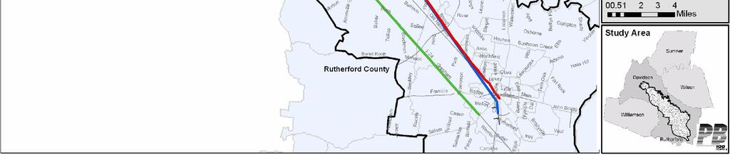
2 Nashville Southeast Corridor Executive Summary I. Introduction The southeast corridor is a 30 mile long corridor that connects downtown Nashville to downtown Murfreesboro. While the connection between these two downtowns has long been significant in the history of the region, it is the explosive outward growth in between these two bookends that has made this corridor so important. The Nashville Area MPO initiated this study to address the existing and future transportation needs of the corridor. In the southeast corridor, residents and commuters are losing significant amounts of time due to heavy traffic congestion, and the area is in danger of losing businesses that must reduce their costs because of their loss of valuable time and money. In addition, a lack of transit options in the corridor restricts mobility for many residents and prevents businesses from accessing needed employees. A potential transit investment can benefit the corridor and the region by reducing transportation costs to citizens and businesses, giving commuters a transportation alternative to the automobile, and promoting strong and sustainable development in the corridor. This study examined potential alternatives for bringing high-capacity, highquality transit service to the corridor and the benefits such service would have to the lives of those who live in, work in and visit the corridor. A number of transit alternatives were considered for the southeast corridor, including bus rapid transit, commuter rail, and light rail alternatives. After an extensive evaluation, the Locally Preferred Alternative (LPA) selected was a combination of phased bus service enhancements, including development of express bus and skip stop bus services on I-24 and Murfreesboro Road (US 41/70S), and extended local bus service on Murfreesboro Road. Other improvements include bus stations at key locations, queue jump and signal improvements at intersections and interchanges to allow buses to bypass congested traffic conditions, and ultimately short sections of busway to further enhance the speed of bus travel in the corridor. The foundation of the LPA recommendation is that it will build a market for transit for the southeast corridor and ensure that quality transit service is available throughout the corridor. The proposed LPA would provide basic transit service in portions of the corridor where none currently exists, ensuring that transit-dependent people have access to employment and educational opportunities in the corridor. In addition, express services will further develop the market for high quality, longer-distance travel service, which was successfully demonstrated by RTA s Relax-and-Ride service that currently operates between Murfreesboro and Nashville. The proposed improvements would be phased in over a period of more than 20 years to allow corridor communities to transition development around station sites toward a more compact, transit and pedestrian-friendly pattern and secure the funding required to develop and operate the services from a variety of local, state and Federal sources. The phased approach will gradually build the public transit market in the corridor, positioning the corridor for further enhancements in transit service after The overall benefit of the LPA for both the southeast corridor and the Nashville region can have a considerable impact. Transit can provide a viable alternative to driving the corridor s congested roadways. By providing service where there currently is none, the Executive Summary - 1


3 LPA can help people reach jobs, thus opening up new employment and educational opportunities in the corridor to the region s residents. Changes in land use that are expected to occur as a result of the proposed LPA would also benefit the region, providing a much needed alternative to the auto-dominated land use patterns that currently exist in the corridor. II. Purpose, Needs and Goals of the Study Study Area The study corridor included the region s largest employment destinations: downtown Nashville, the Vanderbilt-West End area adjacent to downtown Nashville, and downtown Murfreesboro. Other destinations within the corridor include Nashville Airport, Dell, Interchange City, Starwood Amphitheater, Nissan plant, Treveca Nazarene University, Middle Tennessee State University, and the downtowns of LaVergne and Smyrna. Figure 1 shows the boundary of the study corridor Figure 1 SE Corridor Study Area A purpose and need statement was prepared by the study s steering committee in order to identify the needs of the corridor. The following needs were identified: Provide Transportation Options Provide transportation alternatives to driving for travelers within the corridor. Improve Mobility Allow economic growth and development in the corridor to continue without overburdening existing roadways. Reduce the negative impacts of congestion on resources, travel times, and mobility. Executive Summary - 2
4 Establish Efficient Land Use Policies / Compact Development Provide greater emphasis on mixed-use development, traditional urban and village land use patterns, and design standards that support a diverse range of travel options. Promote land uses that are conducive to a more balanced transportation system with a focus on pedestrians and mass transit. Address Environmental Concerns Provide transportation choices that minimize impacts to the environment and help improve air quality conditions in the region. Use Limited Transportation Funding Efficiently Provide a cost effective investment in the transportation network that results in more transportation options and improved mobility, while supporting compact development. Goals for the study were also identified based on the needs of the corridor. Goal 1: Provide Longer-Distance Travelers in the Southeastern Corridor with Alternatives to Driving Private Vehicles in Heavily-Congested Traffic Conditions. Goal 2: Promote Efficient Land Use and Development Patterns in Nashville/Davidson County and the Rutherford County Communities in the Southeast Corridor Study Area. Goal 3: Improve and Enhance Economic Development and Employment Opportunities and Expand Access to Jobs. Goal 4: Preserve the Natural and Social Environment. Goal 5: Develop a Cost-Effective Transportation System Improvement Strategy that Maximizes Community Consensus and Institutional Support. Goal 6: Develop a Strategic Part of a Multi-Modal Transportation System that would facilitate the Development of an Integrated Regional Multi-Modal System III. Evaluation of alternatives Alternatives were developed to address the identified needs of the corridor and goals of the study. The alternatives evaluation process was extensive, with transportation information gathered at each stage incorporated in the development of the next round of alternatives. There were three stages of evaluation: an initial screening, a detailed screening, and a final refinement of the Locally Preferred Alternative (LPA). The final LPA is the official recommendation for transit improvements in the corridor. A pre-screening of alternatives was completed by combining potential alignments with potential transit types. The three major alignments considered for the corridor were I-24, the CSX railroad, and Murfreesboro Road (shorter portions of other alignments were considered in combination with these three major alignments). The types of transit initially considered for the corridor included bus rapid transit (BRT), light rail, heavy rail/subway, monorail, commuter rail, and high speed rail. Another choice, bus rapid transit light (BRTL), defined in the study as bus rapid transit service without a full length busway, was also included in the evaluation process. Table 1 displays the various alignments and transit types in a matrix. The Steering Committee eliminated those combinations of transit or alignment that they thought would be inappropriate or unable to effectively serve the travel needs of the corridor. After this Executive Summary - 3
5 analysis six viable alternatives remained to be studied in the initial round of alternatives screening. Initial Screening An initial screening of these six alternatives was completed by evaluating the characteristics of each alternative with regards to the goals of the project study. In this initial round of screening, many of the alternatives included sub-options in which various alignments to serve Nashville International Airport (BNA) and downtown Nashville were considered. Table 1 Transit Choice Matrix Type of Transit Interstate 24: CSX Railroad: Murfreesboro Road: Commuter Rail Does not apply Appropriate Does not apply Light Rail Appropriate Appropriate Appropriate BRT Appropriate Does not apply Appropriate Heavy Rail/Subway Does not apply Does not apply Does not apply Monorail Does not apply Does not apply Does not apply High Speed Rail Does not apply Does not apply Does not apply These initial alternatives selected were: I-24 BRT I-24 Light Rail CSX Light Rail CSX Commuter Rail Murfreesboro Road Light Rail Murfreesboro Road BRT Amongst the findings from this initial screening were that light rail options would have a tremendously high capital cost many options were well in excess of $500 million in up front capital cost. The Steering Committee determined that such a costly alternative was unlikely to be justified by ridership and other benefits, and thus, light rail was eliminated from further study. BRT, BRT light, and commuter rail were carried forward for further analysis. The screening also revealed that each alignment had its share of positive and negative aspects for a potential transit investment and all three should be moved forward in the screening process. In addition, the initial screening eliminated the Nashville International Airport from consideration in any of the alignments. The cost of a detour to the airport was considered by the Steering Committee to be far larger than the potential benefit. Detailed screening The Steering Committee identified five alternatives to be carried forward to the detailed screening process. Three of these alternatives were carried forward from the initial screening: a BRT alternative on I-24, commuter rail on the CSX rail line, and a BRT alternative operating on Old Nashville Pike. The other two alternatives were used as a comparison with the three build alternatives, including a No-Build Alternative, consisting of the existing system and already funded changes to the transit and roadway networks, and a Low-Cost Alternative that grew out of the bus rapid transit option on I-24. Executive Summary - 4


6 Figure 2 Evaluation of Alternatives corridors Executive Summary - 5
7 The detailed screening again considered the goals of the study when evaluating each of the alternatives, but each alternative was evaluated in greater detail. During this screening, costs and ridership estimates were calculated for each of the remaining build alternatives. These are detailed in the figures below. The high capital costs and low ridership gains for all three build alternatives underscored the need for a low-cost alternative for the corridor. The low ridership also suggested that a phased approach was needed in the corridor to build a transit market over a period of time. As a result of these findings, the Steering Committee developed a low-cost enhanced bus for the Locally Preferred Alternative. This alternative best fit with the characteristics of the corridor and could be tailored to best meet the transportation needs of the corridor and the region. Figure 3 Estimated 2030 Capital Cost Capital costs (in millions) Capital costs (in millions) Low-Cost TSM I-24 BRT Commuter Rail Murfreesboro/Old Nashville BRT Executive Summary - 6
8 Figure 4 Estimated operating costs 6 Estimated annual operating costs (in millions) Operating costs (in millions) Low-Cost TSM I-24 BRT Commuter Rail Murfreesboro/Old Nashville BRT Figure 5 Estimated daily ridership 1800 Estimated 2030 daily ridership Estimated 2030 ridership I-24 BRT Commuter Rail Murfreesboro/Old Nashville BRT Executive Summary - 7
9 Figure 6 shows the estimated boardings of all the alternatives considered. Clearly illustrated in this chart is the fact the no-build scenario will keep transit boardings at a low level. The improvements proposed in the LPA would significantly increase transit use in the corridor. Figure 6 Estimated corridor boardings for all transit alternatives 8,000 7,000 6,000 5,000 4,000 3,000 2,000 No-Build LPA LPA with changes in land use 1,000 0 Year 2030 Daily Boardings IV. Locally Preferred Alternative The LPA selected for the corridor is a phased implementation of packages of relatively low-cost transit improvements. This alternative, also known as Transportation System Management (TSM) or Enhanced Bus, proposes new and expanded bus service along two of the alignments in the corridor, I-24 and Murfreesboro Road. The LPA also proposes a limited number of infrastructure improvements to increase efficiency of the system. These improvements are to be phased in three stages over a 25 year period. Short-term improvements (1 to 5 year period) Improvements proposed for the short-term are aimed at expanding bus service in the corridor and include new express bus service on both I-24 and Murfreesboro Road alignments serving Smyrna, LaVergne and Murfreesboro. Proposed alignments for these services are shown in Figure 7. Mid-Term Improvements (5 to 10 years) Improvements proposed for the mid-term include adding local circulators in LaVergne and Smyrna, introduction of local bus service between Murfreesboro and Bell Road, and construction of queue jump facilities to allow buses to bypass traffic at key I-24 interchanges. Other mid-term improvements include constructing station stops at key Executive Summary - 8
10 bus stops along the corridor, to serve skip stop express bus service and to provide a focus for future transit oriented development and further expanded high capacity transit beyond Proposed locations of improvements are shown in Figure 8. Long-term improvements (10-25 years) Long term improvements in the corridor concentrate on infrastructure improvements to maintain or increase transit efficiency in the corridor. Improvements proposed include the completion of the station stop construction program, the construction of single lane busways in identified congestion areas, and the construction of more queue jump facilities at selected intersections. Locations of these improvements are illustrated in Figure 9. Executive Summary - 9
11 Figure 7 LPA Short-Term Improvements Executive Summary - 10


12 Figure 8 LPA Mid-Term Improvements Executive Summary - 11


13 Figure 9 LPA long-term Improvements Executive Summary - 12
14 Table 2 summarizes the costs of the LPA broken down into the three phases of implementation. Table 2 Breakdown of LPA costs by phase (in 2005 dollars) Cost Summary Capital Annual Operating Incremental Cost Stations Busway/ Streetscape Miles Infrastructure Costs Vehicle Costs Total Capital (over No Build) ($million) 1-5 Years Years Years Total Two ridership estimates were prepared for the Locally Preferred Alternative at full build out, including short, medium and long-term improvements. One is for implementation of the LPA with land use patterns as they currently exist, while the other considered the benefits of compact land use development. Extrapolating current land use patterns to 2030, transit ridership in the corridor is estimated at 6,500 boardings, or 1,300 to 1,600 new boardings per day over the no-build scenario. A second scenario was developed with all expected development in the corridor up to In this scenario, development was channeled to within ½ mile of the skip/stop locations identified with the LPA, causing transit ridership in 2030 to be estimated at 7,300 boardings, or 1,600-2,200 new riders per day. V. Land use recommendations While the LPA concentrates on increasing transit in the corridor, land use will be important in supporting the new proposed transit service. Many studies have noted the connection between transportation choice and land use. Transportation improvements influence land development, which in turn influences future transportation development in a corridor. Public transit does well in areas with more compact, mixed use and, above all, pedestrian friendly development. This transportation and land use relationship also means that areas with good transit service have the potential for higher density, compact development close to stations. The existence of I-24 and the land use choices by local officials in the corridor has made the automobile the dominant form of transportation in the corridor. The low-density development pattern in the corridor reflects this fact. The prevailing land use pattern represents a challenge to building cost-effective high capacity transit services in the corridor. The strategy for implementing the proposed LPA over a 25 year period will allow local officials to prepare the ground for future high capacity transit service by making changes to zoning and land use policies. This will, in turn, allow developers to react to the new zoning and land use policies as well as the increasing availability of high quality transit service in the shaping of their developments. Such a strategy will increase the availability of transit, as well as allow for zoning changes in corridor communities, effecting and gradually shaping development in the corridor in a more transit- and pedestrian-friendly pattern. Transit Oriented Development Transit Oriented Development (TOD) is a form of development that is supportive of public transit service as a large-scale provider of transportation services. In TOD, development is clustered within walking distance of a transit station and buildings are Executive Summary - 13
15 oriented to transit stops rather than to streets or parking lots. Development is mixed, usually with retail, residential, and office uses. While driving is not precluded in a TOD, the mixture of uses can reduce the amount of driving, making walking and taking public transit viable alternatives to driving for many types of trips. TOD is a natural fit for the southeast corridor because development is occurring at a significant rate and the recommended LPA strategy includes building stations at higher use stops. The land surrounding these higher use stops could be developed (or in some cases redeveloped) to include pedestrian and transit friendly uses, which would support the ongoing development of transit through 2030 and beyond. VI. Implementation and Conclusions The southeast corridor has many assets that can help support transit, including walkable downtowns at each end of the corridor, colleges and universities, large retail, office and industrial developments, and a rapidly growing population and employment base. The proposed LPA seeks to build the market for public transportation in the corridor by providing service where there is none, providing improved services and facilities, and generally getting commuters used to the idea that transit is a viable transportation option in the corridor. Implementation of the proposed LPA will be both a regional and local effort. Regional transit officials must identify a multi-faceted funding strategy for the development of facilities, purchase of vehicles and on-going operation of transit services in the corridor. Local officials must begin addressing both funding and land use issues to support the new facilities and services proposed for the corridor. Once the LPA has been implemented gradually over the 25 year period, it is likely that further transit improvements, potentially including commuter rail or light rail transit, could be implemented in the corridor at some point after However, such improvements will depend on the identification of a funding strategy and the implementation of transit supportive land use policies to make the most efficient use of transit investments in the corridor. Executive Summary - 14
4.0 Phase I Screening of Alternatives
 4.0 Phase I Screening of Alternatives 4.1 Introduction The region s vision for a multi-county transit system to enhance mobility and provide a safe and efficient multimodal network is illustrated in both
Nashville Area Transit Development Plan
 Nashville Area Transit Development Plan Final Report Nashville Area Metropolitan Planning Organization June 2003 Prepared by: with Fischbach Transportation Group Looney Ricks Kiss Table of Contents Introduction...
KNOXVILLE REGIONAL TRANSIT CORRIDOR STUDY
 KNOXVILLE REGIONAL TRANSIT CORRIDOR STUDY April 2013 Alignments Alignments Magnolia Ave Northeast corridor Knoxville Transit Center Hall of Fame Dr Magnolia Ave Prosser Rd. Corridor contains commercial,
FUTURE BUS RAPID TRANSIT PLANS
 ATTACHMENT 1 Preferred Configuration Saskatoon Bus Rapid Transit - Preferred Configuration FUTURE BUS RAPID TRANSIT PLANS Plan For Growth Transportation Plan BRT Plan October 2017 saskatoon.ca/engage 1
Contents i Contents Page 1 A New Transportation Plan Community Involvement Goals and Objectives... 11
 Contents i Contents 1 A New Transportation Plan... 1 Why develop a new plan?... 1 What area does the LRTP focus on?... 2 Why is this LRTP important?... 3 Meeting Requirements for Transportation Planning...
TSM/TDM (Transit and Roadway Efficiency) Concept - Analysis and Results
 Concept - Analysis and Results") M E M O R A N D U M TSM/TDM (Transit and Roadway Efficiency) Concept - Analysis and Results TO: FROM: Task Force and Oversight Team Steve Perone/PTV America Tim Burkhardt/CH2M HILL DATE: Revised: August
M E M O R A N D U M TSM/TDM (Transit and Roadway Efficiency) Concept - Analysis and Results TO: FROM: Task Force and Oversight Team Steve Perone/PTV America Tim Burkhardt/CH2M HILL DATE: Revised: August
3.0 Needs Assessment and Evaluation Methodology
 TPTPTPTP PTPTPTPT Population 3.0 Needs Assessment and Evaluation Methodology 3.1 Introduction The Needs Assessment and Evaluation Methodology identifies the problems and opportunities in the Southeast
Rapid Transit in Winnipeg. Winnipeg TOD Summit November 17, 2014
 Rapid Transit in Winnipeg Winnipeg TOD Summit November 17, 2014 Presentation Overview Rapid Transit (RT) in Winnipeg What is RT? What are our RT plans? Near term Longer term Comments re: TOD OurWinnipeg
Chapter 5 Service Delivery Policy and Implications
 Chapter 5 Service Delivery Policy and Implications One of the critical steps in the preparation of a Strategic Transit Master Plan is the articulation of the objectives to be served by the transit system,
APPENDIX B - GLOSSARY FEBRUARY 2017
 APPENDIX B - GLOSSARY FEBRUARY 2017 DENVERMOVES Transit Denver Moves: Transit - ii - APPENDIX B TRANSIT AND MOBILITY GLOSSARY Amenities, stop or station: Objects or facilities (such as a shelter, bench,
Nashville Regional Freight & Goods Movement Study Phase III
 Mayor Karl Dean, Chairman Nashville Regional Freight & Goods Movement Study Phase III Freight Advisory Committee Meeting #2 June 3 rd, 2015 Agenda Update on Freight Vision/Regional Truck Route Network
SCS Scenario Planning
 E SCS Scenario Planning Introduction As part of the 2035 MTP/SCS process, AMBAG developed a series of land use and transportation alternative scenarios for evaluation and testing to demonstrate how the
TRANSPORTATION RELATIONSHIP TO OTHER ELEMENTS OF THE PLAN AND COUNTY REGULATIONS VISION FOR TRANSPORTATION PLANNING ROAD NETWORK SECTION 7
 TRANSPORTATION Like many growing western counties, Douglas County focuses on one of the most integral elements in land-use planning: transportation. The primary purpose of a transportation network is to
09Scenario. Evaluation. CHAPTER 9: Scenario Evaluation 85. Modesto Junior College, Modesto, CA
 09 Evaluation Modesto Junior College, Modesto, CA CHAPTER 9: Evaluation 85 86 2018 Regional Transportation Plan/Sustainable Communities Strategy Historic Downtown, Turlock, CA 9 SCENARIO EVALUATION Testing
EXECUTIVE SUMMARY REGIONAL TRANSPORTATION PLAN 2050
 EXECUTIVE SUMMARY REGIONAL TRANSPORTATION PLAN 2050 Introduction Goals Policies, and Performance Measures Growth Forecast and Planned Land Use Development Key Recommendations i Executive Summary April
Chapter 4: Transportation and Land Use
 Chapter 4: Transportation and Land Use Transportation and land use together make possible the wide range of destination opportunities in the region. Transportation provides the connections, and, in turn,
Master Plan. Summary
 R e g i o n a l Tr a n s p ortat i o n Master Plan Summary Executive Summary With an increasing population and changing demographics, Waterloo Region must ensure that growth is both sustainable and affordable.
Project Evaluation Criteria
 Project Evaluation Criteria Goals and Objectives were developed to guide Envision 35 Long Range Transportation Plan (LRTP) Update. These guiding principles were based on the requirements included in the
VISION STATEMENT, MISSION STATEMENT, AND GOALS AND OBJECTIVES
 VISION STATEMENT, MISSION STATEMENT, AND GOALS AND OBJECTIVES Vision Statement: Our vision is to provide a high quality, safe, efficient, and cost-effective multi-modal transportation system that supports
Executive Summary and Staff Recommendation
 Executive Summary and Staff Recommendation January 2017 Project Background In 2010, NFTA completed an update to our 2001 Strategic Assessment. This assessment identified four corridors for potential rail
09Scenario Evaluation
 09 Evaluation CHAPTER 9: Evaluation 73 74 2018 Draft Regional Transportation Plan/Sustainable Communities Strategy 9 SCENARIO EVALUATION Testing The four scenarios discussed in the previous chapter were
APPENDIX N East King County Subarea High Capacity Transit (HCT) Analysis: Approach to Assessing System-Level Alternatives
 Analysis: Approach to Assessing System-Level Alternatives") Sound Transit Regional Transit Long-Range Plan Draft Supplemental Environmental Impact Statement APPENDIX N East King County Subarea High Capacity Transit (HCT) Analysis: Approach to Assessing System-Level
Sound Transit Regional Transit Long-Range Plan Draft Supplemental Environmental Impact Statement APPENDIX N East King County Subarea High Capacity Transit (HCT) Analysis: Approach to Assessing System-Level
South Fulton Parkway Transit Feasibility Study Stakeholder Committee Meeting #2
 South Fulton Parkway Transit Feasibility Study Stakeholder Committee Meeting #2 June 8, 2009 Meeting Agenda I. Study Purpose and Schedule II. III. Review of Previous Plans and Studies Transit Propensity
BUS RAPID TRANSIT CORRIDOR
 DOWNTOWN UPTOWN OAKLAND EAST END BUS RAPID TRANSIT CORRIDOR Scoping Booklet for National Environmental Policy Act Review City of Pittsburgh Port Authority of Allegheny County Uptown/Downtown Scoping Meeting
VDOT and DRPT MPO and PDC Winter Meeting Amy Inman Planning & Mobility Programs Administrator Virginia Department of Rail and Public Transportation
 VDOT and DRPT MPO and PDC Winter Meeting Amy Inman Planning & Mobility Programs Administrator Virginia Department of Rail and Public Transportation www.drpt.virginia.gov 1 DRPT Customers 54 Transit Systems
FINAL. Technical Memorandum #2: Alternative Scenarios Performance Report
 General Planning Consultant Services RFP P5413 Contract No. 200703566 Work Order No. 2009-01 / Task 2-3 FINAL S O U T H F U LTO N PA R K W AY T R A N S I T F E A S I B I L I T Y S T U DY Technical Memorandum
SOUTHWEST LRT (METRO GREEN LINE EXTENSION)
") 8 Evaluation of Alternatives This chapter evaluates the effectiveness of the No Build Alternative and the Southwest Light Rail Transit (LRT) Project (the Project) based on the information contained in
8 Evaluation of Alternatives This chapter evaluates the effectiveness of the No Build Alternative and the Southwest Light Rail Transit (LRT) Project (the Project) based on the information contained in
Consequences of Sprawl
 Loss of farmland Land conversion and stormwater runoff Water quality and quantity Loss of wildlife habitat Larger carbon footprint Lack of roadway connectivity and access Public health and safety Road
12 Evaluation of Alternatives
 12 Evaluation of Alternatives This chapter evaluates the effectiveness of the No-Build Alternative and the proposed METRO Blue Line Light Rail Transit (BLRT) Extension project based on the information
Midtown Corridor Alternatives Analysis. Technical Advisory Committee Meeting November 15, 2012
 Midtown Corridor Alternatives Analysis Technical Advisory Committee Meeting November 15, 2012 Today s Agenda Introductions Roles and Responsibilities Alternatives Analysis Process Overview Outreach Overview
This document has been developed to provide context to the Board as part of the strategic planning process. Regional development and travel trends
 1 This document has been developed to provide context to the Board as part of the strategic planning process. Regional development and travel trends and forecasts are provided, including population, employment,
TRANSIT SYSTEM SUMMARY REPORT
 Genesee County Shaping our Transportation Future Together 2035 Long Range Transportation Plan TRANSIT SYSTEM SUMMARY REPORT Introduction The Genesee County Transit Technical Report is one of 19 technical
Transit Service Guidelines
 G R E AT E R VA N CO U V E R T R A N S P O RTAT I O N A U T H O R I T Y Transit Service Guidelines PUBLIC SUMMARY REPORT JUNE 2004 Greater Vancouver Transportation Authority TRANSIT SERVICE GUIDELINES
SOUTHEAST FLORIDA REGIONAL COMPACT CLIMATE CHANGE. Sustainable Communities & Transportation Planning
 SOUTHEAST FLORIDA REGIONAL COMPACT CLIMATE CHANGE Draft Regional Climate Action Plan Sustainable Communities & Transportation Planning SP-1 Develop criteria in collaboration with municipal and county planning
Chapter 1: Overview. page 1. Figure 2-1: Road congestion is expected to continue to grow
 Chapter 1: Overview Figure 2-1: Road congestion is expected to continue to grow The region s mobility so fundamental to its economic vitality and quality of life is challenged by mounting congestion, rising
MEMORANDUM #4. DATE: November 4, Warrenton TSP Project Management Team. Ray Delahanty, AICP, DKS Associates Kate Petak, EIT, DKS Associates
 MEMORANDUM #4 DATE: November 4, 2015 TO: FROM: SUBJECT: Warrenton TSP Project Management Team Ray Delahanty, AICP, DKS Associates Kate Petak, EIT, DKS Associates Warrenton Transportation System Plan Update
EIGHT PLANNING FACTORS
 EIGHT PLANNING FACTORS Under the provisions of SAFETEA-LU, all Metropolitan Planning Organizations (MPOs) are required to consider eight (8) broad planning factors in the development of multi-modal transportation
4: Transportation and Land Use
 Chapter Figure 4-1: Recent development has brought more housing and mixed use Downtown Minneapolis - looking north from E 15th Street at the Grant Street / 11th Street exit 4: Transportation and Land Use
VelociRFTA BRT. Roaring Fork Transportation Authority. Webinar: Transit Planning with a Land Use Lens. August 23, 2011
 VelociRFTA BRT Roaring Fork Transportation Authority Webinar: Transit Planning with a Land Use Lens August 23, 2011 David Johnson, AICP RFTA Director of Planning RFTA Service Summary 70-Mile Corridor 75,000
Chapter 3 Stakeholder Interviews and Summary of Needs
 Chapter 3 Stakeholder Interviews and Summary of Needs 42 CHAPTER 3 STAKEHOLDER INTERVIEWS AND SUMMARY OF NEEDS CHAPTER 3. STAKEHOLDER INTERVIEWS AND SUMMARY OF NEEDS An extensive stakeholder interview
KRM COMMUTER RAIL RATES HIGH WITH PUBLIC INSIDE THE KENOSHA-RACINE-MILWAUKEE COMMUTER LINK
 KRM THE KENOSHA-RACINE-MILWAUKEE COMMUTER LINK COMMUTER RAIL RATES HIGH WITH PUBLIC Earlier this year, the initial series of public informational scoping meetings for this phase of the KRM project was
EXAMPLES OF COMPREHENSIVE PLAN POLICIES HOW TO ESTIMATE THE BENEFITS OF THE CTR PROGRAM
 TABLE OF CONTENTS INTRODUCTION... I BACKGROUND OF THE COMMUTE TRIP REDUCTION EFFICIENCY ACT... II MAKING THE CONNECTION BETWEEN COMMUTE TRIP REDUCTION AND THE GROWTH MANAGEMENT ACT... IV CTR PLANNING AND
POLK COUNTY TPO Polk County 2060 Transportation Vision Plan Final Report. ADOPTED June 18, 2009
 POLK COUNTY TPO Polk County 2060 Transportation Vision Plan Final Report ADOPTED June 18, 2009 TABLE OF CONTENTS CHAPTER 1 Introduction and Prior Planning Effort...Page 1-1 CHAPTER 2 Population and Employment
Nashville Strategic Transit Tel Master Plan Draft Final Fax
 TranSystems One Cabot Road Medford, MA 02155 Nashville Strategic Transit Tel 781.396.7775 Master Plan Draft Final Fax 781.396.7757 Report www.transystems.com Nashville Metropolitan Transit Authority July
Bus Rapid Transit Network Marketing Strategy
 2017 June 28 Page 1 of 8 EXECUTIVE SUMMARY The City is building four Bus Rapid Transit (BRT) routes that will fill important gaps in the rapid transit network, and provide efficient, reliable and convenient
Appendix F 2008 Travel Demand Modeling
 Appendix F 2008 Travel Demand Modeling TRAVEL DEMAND MODELING Purpose: The Jackson/Teton County Comprehensive Plan Update is revisiting land use and transportation planning policies to ensure they can
Background. Purpose of This Phase of Project Development
 Background Purpose of This Phase of Project Development Analyze costs and benefits of commuter rail and bus rapid transit in corridor Refine and update alternatives considered to date Update costs and
ACTIVE TRANSPORTATION ADVISORY COMMITTEE. Memphis MPO March 30, 2015
 ACTIVE TRANSPORTATION ADVISORY COMMITTEE Memphis MPO March 30, 2015 Agenda Welcome & Introductions Announcements and Briefings Livability 2040: Regional Transportation Plan Congestion Management Process
Summary of transportation-related goals and objectives from existing regional plans
 SMTC 2050 Long Range Transportation Plan Appendix A: Summary of transportation-related goals and objectives from existing regional plans SMTC 2050 Long Range Transportation Plan Summary of transportation-related
2040 LAND USE WORKBOOK February 2017
 040 LAND USE WORKBOOK February 017 S A/C INTRODUCTION SITE SPOTLIGHT: WATERFRONT Through a series of community workshops and online activities in 016, Stockton community members shared their vision for
October 31, Honorable Patty Murray United States Senate Washington, DC. Dear Senator Murray,
 October 31, 2002 Honorable Patty Murray United States Senate Washington, DC Dear Senator Murray, We want to thank you for your service to our State and our beautiful Puget Sound Region. Your attention
APPENDIX A: Transportation Planning Rule
 A APPENDIX A: Transportation Planning Rule This appendix contains the full text of Oregon s Transportation Planning Rule (TPR). Transportation Planning Rule (TPR) NOTE: The official copy of an Oregon Administrative
King of Prussia Rail Project Frequently Asked Questions - Archive Version: Summer 2018
 - Archive Version: Summer 2018 These frequently asked questions (FAQ) have been developed to help residents, businesses and area stakeholders develop a better understanding of the proposed King of Prussia
1560 Broadway, Suite 700, Denver, CO phone
 RESOLUTION NO. 1 SERIES OF 2006 REVISED TRANSIT ORIENTED DEVELOPMENT POLICY Whereas, the Board of Directors has determined that transit oriented development (TOD) can enhance the value and effectiveness
Transportation and Utilities
 4 Section 4 Transportation and Utilities 4.0 Introduction Transportation and utility systems are essential to accommodate and support development proposed in the Future Land Use Map. The following pages
3.0 REVIEW OF PREVIOUS STUDIES
 3.0 REVIEW OF PREVIOUS STUDIES This section of the highlights the significant features from previous plans and studies that could impact the development of the I-20 East Transit Initiative. Much of the
Section 11: Transportation Strategies Toolbox
 Section 11: Transportation Strategies Toolbox A transportation strategies toolbox was developed to provide a systematic approach to identify potential strategies that address corridor transportation needs.
6.0 CONGESTION HOT SPOT PROBLEM AND IMPROVEMENT TRAVEL DEMAND MODEL ANALYSIS
 6.0 CONGESTION HOT SPOT PROBLEM AND IMPROVEMENT TRAVEL DEMAND MODEL ANALYSIS 6.1 MODEL RUN SUMMARY NOTEBOOK The Model Run Summary Notebook (under separate cover) provides documentation of the multiple
Transit Investment Direction and Plan Introduction. Transportation Advisory Board TPP Workshop August 16, 2017
 Transit Investment Direction and Plan Introduction Transportation Advisory Board TPP Workshop August 16, 2017 Today s Topics - Transit Where are we now, what are the current issues? Where do we want to
in the Fraser Valley Foundation Paper #4
 S t r a t e g i c R e v i e w o f Tr a n s i t in the Fraser Valley Foundation Paper #4 Exploring the Possibilities for the Fraser Valley Prepared by: TABLE OF CONTENTS 1.0 INTRODUCTION... 1 1.2 THE PROCESS...
Sustainable Transportation & Land Use Integration Study
 Sustainable Transportation & Land Use Integration Study Stakeholders Group Meeting Two Includes additions made after meeting March 28, 2011 Hot Topics: Emerging themes, technologies, and techniques Outline
Land Use Vision and Transportation Strategy
 Phase 1: Land Use and Transportation Strategy June 3, 2015 ing Workshop #2 Phase 1: Land Use and Transportation Strategy Welcome March 12 Workshop Summary Discussion Strategies to Implement the Next Steps
Subarea Mobility Enhancements. 5.1 Transit and Pedestrian Improvements
 Section Five Section 5: Subarea Mobility Enhancements 5.1 Transit and Pedestrian Improvements From the outset of the master planning process, one of the primary goals was to integrate transit and pedestrian-oriented
EMU: BN/UP ALTERNATIVE ARVADA RIDGE STATION OPTION A
 OPTION A OPTION A: GOLD LINE TEAM ANALYSIS Option A Parking on the Southwest corner of Ridge & Kipling Operational Community Environmental ADVANTAGES Good access off of Kipling at 51 st Place Good community
Overview of Alternatives Analysis
 Red Line/HealthLine Extension Major Transportation Improvement Analysis Greater Cleveland Regional Transit Authority Public Meeting: February 11, 2016 Final Report Overview of Alternatives Analysis Public
Public Input from Regional Visioning Forums
 Public Input from Regional Visioning Forums Innovation and Economic Development Provide transportation systems to continue to position Florida as a global hub for trade, logistics, and exports-oriented
Chapter 2 Transportation Element Goals, Objectives and Policies
 Chapter 2 Transportation Element Goals, Objectives and Policies City of Belleview Comprehensive Plan Adopted by Ord 2016-10 on July 5, 2016 GOALS, OBJECTIVES AND POLICIES Goal 2 Transportation...1 Objective
Gateway Corridor Transitway
 Locally Preferred Alternative Summary Gateway Corridor Transitway 1 Metropolitan Council, Nov. 12, 2014 Gateway Corridor Transitway Proposed highcapacity transit improvement connecting east metro suburbs
KAW CONNECTS EXECUTIVE SUMMARY
 Executive Summary Page E-1 Introduction KAW CONNECTS EXECUTIVE SUMMARY The Kansas Department of Transportation (KDOT) and the Kansas Turnpike Authority (KTA) have both recognized the need to plan for the
The Role of Transportation Systems Management & Operations in Supporting Livability and Sustainability
 The Role of Transportation Systems Management & Operations in Supporting Livability and Sustainability Michael Grant, ICF International February 7, 2012 NTOC Webinar Highlights of FHWA/FTA Primer Background:
Moving the first state forward! Delaware s Statewide Long- Range Transportation Plan November 17, 2010 WILMAPCO Our Town
 Moving the first state forward! Delaware s Statewide Long- Range Transportation Plan November 17, 2010 WILMAPCO Our Town Moving the First State t Forward Today s problems yesterday s decisions. Implementation
ONE NEVADA TRANSPORTATION PLAN The Nevada Department of Transportation s Long-Range Transportation Plan
 Executive Summary The s Long-Range Transportation Plan SAFETY, INFRASTRUCTURE, MOBILITY, ECONOMY, SUSTAINABILITY, COMMUNITY This Plan is Our Plan! A Transportation Plan by Nevadans, for Nevada How safely,
2030 Transportation Policy Plan SUMMARY PRESENTATION. Land Use Advisory Committee November 15, 2012
 2030 Transportation Policy Plan SUMMARY PRESENTATION Land Use Advisory Committee November 15, 2012 Today s Topics Transportation Policy Plan (TPP) Requirements and Background Current TPP Policies, Issues
Traffic Signal Timing: What s Your Priority? Transportation Education Series May 8, 2012
 Traffic Signal Timing: What s Your Priority? Transportation Education Series May 8, 2012 Presentation Outline New Direction in Traffic Signal Timing Manual Applications Why Are We Doing This Project? Improve
CHAPTER 5. City of Greensburg Comprehensive Plan. Introduction. Transportation Goals & Objectives
 CHAPTER 5 TRANSPORTATION Introduction The transportation system forms the backbone of the community. I-74 provides the community with connections to larger metropolitan areas such as Indianapolis and Cincinnati.
Updated Traffic Impact Analysis Regulations Administrative Guidelines
 Updated Traffic Impact Analysis Regulations Administrative Guidelines 24VAC30-155 January 2012 Land Development Section Transportation and Mobility Planning Division Virginia Department of Transportation
Fresno County Measure C Transit Oriented Development (TOD) Program Policies and Guidelines
 Program Policies and Guidelines") Fresno County Measure C Transit Oriented Development (TOD) Program Policies and Guidelines The TOD program was created in the 2006 Measure C Extension Plan. The goals of the Measure C Transit Oriented
Fresno County Measure C Transit Oriented Development (TOD) Program Policies and Guidelines The TOD program was created in the 2006 Measure C Extension Plan. The goals of the Measure C Transit Oriented
1.1.1.b. Agencies share best practices as they integrate COMPASS facilitates
 Transportation Goals 1.1 Enhance the system to improve accessibility and connectivity to jobs, schools, and services; allow the efficient movement of people and goods; and ensure the reliability of travel
2. Guiding Principles, Objectives, and Policies
 2. Guiding Principles, Objectives, and Policies INTRODUCTION The guiding principles for the 2040 MTP Update establish the vision and key focus areas for this planning effort. They combine the guidance
Lynnwood Link Extension 2013 Draft EIS Comments and Responses. Page 945
 I-441-001 Thank you for your comments about the importance of the Latvian Center to the Latvian community. Following the Draft EIS, the Sound Transit Board directed Sound Transit to develop a Preferred
GUIDING PRINCIPLES MPO TRANSIT STUDY
 GUIDING PRINCIPLES MPO TRANSIT STUDY TECHNICAL MEMORANDUM MAY 17, 2007 Hillsborough County Metropolitan Planning Organization County Center, 18 th Floor Tampa, Florida 33602 813-272-5940 www.hillsboroughmpo.org
SUBURBAN EDGE COMMUNITY ROLE COUNCIL ROLE ALL COMMUNITIES SUBURBAN EDGE
 Orderly and Efficient Land Use Align land use, development patterns, and infrastructure to make the best use of public and private investment. Plan and stage development for forecasted growth through 2040
Chapter 14 Work Program
 Chapter 14 Work Program The Metropolitan Council will carry out or participate in many studies and plans over the next three years. This is not an exhaustive list of all work to be completed by the Metropolitan
Fairfax County Countywide Transit Network Study
 Fairfax County Countywide Transit Network Study Proposed High Quality Transit Network Concept Metropolitan Washington Council of Governments Travel Forecasting Subcommittee September 20, 2013 1 Presentation
Saskatoon BRT A Catalyst for City Building
 Saskatoon BRT A Catalyst for City Building Chris Schulz, Growth Plan Manager, City of Saskatoon John Hubbell, Associate Vice President, HDR Paper prepared for presentation at the Best Practices in Urban
Mobility and System Reliability Goal
 Mobility and System Reliability Goal Provide surface transportation infrastructure and services that will advance the efficient and reliable movement of people and goods throughout the state. Background:
VIA Long Range Plan Glossary
 VIA Long Range Plan Glossary Accessibility. Accessibility is the ability to reach opportunities (economic, social, etc.) within a certain geographical area. Americans with Disabilities Act (ADA). Passed
Final. Project Summary Report
 Final Project Summary Report February 2017 TABLE OF CONTENTS PROJECT SUMMARY REPORT FINAL Prepared for: FDOT District 5 Prepared by: Parsons Brinckerhoff, Inc. March 2017 i February 2017 TABLE OF CONTENTS
TECHNICAL ADVISORY COMMITTEE. January 29, 2013
 TECHNICAL ADVISORY COMMITTEE January 29, 2013 1 Introductions and Review Common TAC and PAG comments TAC-specific input Refined Draft Scoring Factors/Transit Development Strategy review Revised Transit
Sound Transit Long-Range Plan Update/SEIS Agency Scoping Meeting. November 8, 2013
 Sound Transit Long-Range Plan Update/SEIS Agency Scoping Meeting November 8, 2013 1 Agency Scoping Meeting for the Long- Range Plan (LRP) Update/Supplemental Environment Impact Statement (SEIS) Introductions
Infrastructure and Growth Leadership Advisory Group Ideas and Approaches Survey
 Infrastructure and Growth Leadership Advisory Group Ideas and Approaches Survey Maintain transportation system in state of good repair 1. Increase focus on maintenance of existing infrastructure in poor
2040 Transportation Policy Plan Conversion to Performance Based Planning Basis. 25 th Annual CTS Transportation Research Conference May 21, 2014
 2040 Transportation Policy Plan Conversion to Performance Based Planning Basis 25 th Annual CTS Transportation Research Conference May 21, 2014 1 About the plan Long-range transportation plan for the Twin
SCENARIO PLANNING 12
 12 SCENARIO PLANNING Scenario planning represents the next generation of analytical processes created to evaluate the influence of development intensities and land use patterns on the efficiency of a proposed
Agenda. Public Input: Results from Open House 1. Evaluation Criteria: FTA and Local Considerations
 Agenda Jackson County Commuter Corridors Alternatives Analysis Stakeholder Advisory Panel Meeting Two 2:30 p.m. November 16, 2011 Kansas City Area Transportation Authority, 1200 E. 18 th, Kansas City,
Measuring Success: Using data wisely for a healthier, wealthier, more equitable city. NACTO Conference, October 2013.
 Measuring Success: Using data wisely for a healthier, wealthier, more equitable city NACTO Conference, October 2013 Jeffrey Tumlin Commonly Used Performance Measures Source: Reid Ewing Old Speed Paradigm
South Bay Metro Green Line Extension
 Meeting Agenda Project overview and update Recap of the Scoping Meetings Progress on the project alternative and proposed station locations Meeting Schedule 6:00 Open House 6:30 Presentation 7:15 Public
Technical Memorandum#1A
 Technical Memorandum#1A Goals, Objectives, and Performance Measures AMATS 2040 Metropolitan Transportation Plan Prepared for: AMATS Prepared by: HDR Approved by AMATS PC September 28, 2017 This page intentionally
Technical Advisory Committee Meeting #1. December 13, 2011 MARTA Headquarters
 Technical Advisory Committee Meeting #1 December 13, 2011 MARTA Headquarters Meeting Agenda Project Purpose Project Schedule TAC s Roles and Responsibilities Study Area Previous Studies Big Themes from