RIDOT S Statewide Roadway and Asset Data Collection Project
|
|
|
- Gilbert Mathews
- 5 years ago
- Views:
Transcription


1 RIDOT S Statewide Roadway and Asset Data Collection Project ESRI User Conference 2017 Rafiq Basaria, DTS; Daniel Behnke DTS, Shane White, RIDOT Accent image here Primary Image here
2 What is MIRE? Recommended Listing of Roadway and Traffic Inventory Elements Guideline for Agencies Critical to Safety Management Helps Move Agencies Towards Use of Performance Measures Benefits Beyond Safety Decision Makers Asset Management Infrastructure Operations Maintenance
3 Why Do We Need This Data? Identify risk factors From crash data From roadway data From other studies Intersection Features: Intersection skew angle Intersection traffic control device Number of signal heads vs. number of lanes Presence of backplates Presence of advanced warning signs Intersection located in/near horizontal curve Presence of left-turn or right-turn lanes Left-turn phasing Allowance of right-turn-on-red Roadway Features: Number of lanes Lane width Shoulder surface width/type Median width/type Horizontal curvature Roadside or edge hazard rating Driveway density Presence of shoulder or centerline rumble strips Presence of lighting Presence of on-street parking Pedestrian Features: Crosswalk presence Crossing distance Signal head type Adjacent land uses Lighting
4 MIRE Across Datasets
5 Type of Data in MIRE Segment Location / Linkage Elements Street Name, Route Number, Town Code, Etc. Segment Classification Functional Class, Rural / Urban, Etc. Segment Cross Section Surface Descriptors Surface Type, Pavement Condition, Etc. Lane Descriptors Number of Lanes, Cross Slope. Etc. Shoulder Shoulder Type, Sidewalk Presence, Etc. Median Median Type, Side Slope, Etc. Roadside Clear Zone, Driveway Count, Etc.
6 Type of Data in MIRE Segment Traffic Operations / Control Data One/Two Way, Speed Limit, Roadway Lighting, Etc. Horizontal Curve Data Curve Degrees, Curve Length Vertical Grade Roadway Junction Descriptors (Intersections) General Descriptors Type of Intersection, Number of Legs, Signal Presence, Etc Each Approach Through Lanes, Median Type, Crosswalk Presence, Etc. Interchange and Ramps Descriptors Interchange Type, Number of Lanes, Speed
7 MIRE Data Collection Effort Timeline Scope of Work June 2013 RFP Completed May 2014 NTP September 2014 Data Collection Completed December 2015 Beginning to use the data to perform predictive safety analysis, particularly on corridors Scope of Work Collect 180 of 202 MIRE Elements Traffic Volume Related Elements Not Collected (79-90, , 160, , 184, ) Also Responsible for Collecting ROW Imagery, Pavement Roughness & Distress Data, LIDAR, and Additional Asset Data
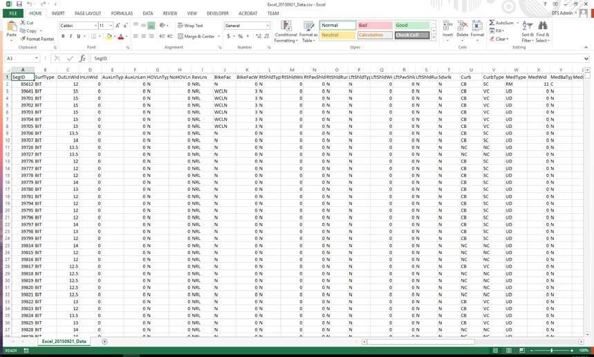
8 Asset Data Collected Pavement Roughness, Rutting, Patching, Bleeding Collected on State, NHS, Numbered Routes, Ramp, Municipal Federal Aid Mobile LiDAR for 1300 Miles of State Road and Some Ramps ROW Imagery for State Roads Asset Features Statewide Road Inventory Signs State Roads Guardrail Walls Catch Basins and Manholes Striping Bridge Vertical Clearance
9 Data Integration and Governance Data Integration Through ESRI Roads & Highway Implementation Conversion From Multiple LRSs Supporting Various Business Systems to a Unified LRS Platform (While Supporting Multiple LRMS) Supporting Bi-Directional Data Flow and Consistent Location Referencing Across Business Systems Rhode Island Local/State Data Integration For Asset Management and Safety Analysis In Progress Develop processes and identify staffing and resources needed to guarantee the ongoing maintenance and utility of the roadway location and MIRE inventory data Manage data integration and assist the RIDOT in developing processes for integration of the new MIRE data into ESRI Roads and Highways Support use of advanced analytic tools/methodologies through example analyses and training on data extraction/integration processes


10 Automated Sync ing of Business Systems with LRS Business systems Web Service Connections extend access to data inside/ outside the organization, providing access to local & regional government Web services communicate the last synchronization date Web services communicate route and measure changes to business records Local & regional government can participate in the maintenance of the database Rules define how events are updated LRS Change LRS Editor Geodatabase All edit activities are time stamped and stored

11 Roadway Characteristics Editor (RCE) Roads & Highways Road Characteristic Editor (RCE) provides a web portal that can be configured to provide access to local/regional government Local & regional government can actively participate in the maintenance of the road network

12 Data Model MIRE has no standardized data model, only guidance Wanted something basic that could be improved upon Needed something that could easily be edited and moved to various formats


13 Data Collection MAC vehicles collect data along predefined routes Directionality important consideration Mutliple datasets with differing priority levels GPS tracks used to track collection


14 Data Population Data from various sources Aerial imagery ROW imagery (collected by MAC vehicles) LiDAR Existing RIDOT data
15 Data Population


16 Data Population Data populated at 1/10 th of a mile segments Coded domain values used Populated specifically based on type of roadway elements


17 Curves Biggest hurdle with data New process that seemed to have never been done before. Developed Python scripts to detect curves Scripts use point data created from LRS to determine curve start/end measures, length, and radius of curve


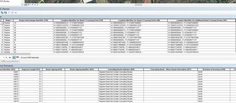
18 QC Before Delivery to RIDOT Initial QC performed by Michael Baker Manual and Automated QC performed Mainline 86,522 segments, 6,932 miles, 120 MIRE Elements Intersections 16,215 intersections, 49,337 intersections approaches, 57 Elements Ramps 444 ramps, 25 Elements
19 QC Before Delivery to RIDOT Manual processes used to QC data using symbology Find areas where symbology differs, and could potentially be errors Applied to attributes such as speed limit, sidewalk presence, median information, etc. Reports delivered in the form of word documents describing issue with screen captures for specific Segment IDs Automated processes Scripts built for cross attribute validation and domain validation Applied to all datasets Validation rules developed based on MIRE guidelines 80 cross attribute validations 90 domain validations Reports delivered to DTS in the form of CSV files with issues listed by Segment ID
20 Lessons Learned/Challenges No standard data model for MIRE Had to develop data model Numerous iterations to work out best geometric and attribute representations Built GDB with domains for all MIRE Elements that could be coded DOTs vs Consulting Managing expectations Keeping all participants up-to-date on project status LRS updates during project
21 Lessons Learned/Challenges (Cont d) FHWA should develop a geospatial data model for use by any agency interested in implementing MIRE. The data model should template GIS feature classes, attribute domains within each feature class, and necessary relationship classes between features. A substantial amount of time was spent by the MIRE Contractor developing a GIS data model to house the MIRE data collection. MIRE Contractor identified the need for additional details for each MIRE element to be located in a single reference document. Although safety engineers are the primarily consumers of the MIRE data, data collection Contractors are more likely to be experts in GIS or mobile data collection technology, without in-depth knowledge of each MIRE element.
22 Lessons Learned/Challenges (Cont d) MIRE junction elements are split between two types of geometry: A point feature with attributes describing the intersection; 3 or more linear features representing the intersection approaches. Each intersection represented as a point with attributes describing the intersection. Intersection approach elements stored in a Related Table and linked to the intersection point based on the intersection identifier. MIRE does not require the intersection approach to be linked to the road segment ID, only the intersection ID. Poses a problem when implementing Safety Analyst and linking crash data to segments and approaches.
23 Moving Forward MIRE Road Inventory to be Imported into Esri Roads & Highways and Managed as part of RIDOT s LRS MIRE elements will be dissolved from 1/10 mile centerline segments into LRS routes with event tables Develop Geoprocessing Tools to Extract Data from Esri Roads & Highways for import into Safety Analyst Safety Analyst will not work with the Esri Roads & Highways event tables Additional data fields (processed from existing attributes) required for import to Safety Analyst MIRE Element Attribute Definitions differ from Safety Analyst Requirements Two Options: Manually attribute map the MIRE attribute definitions within Safety Analyst as part of the data import process Translate MIRE attributes to Safety Analyst definitions through scripting outside of Safety Analyst

24 Comments & Questions
RIDOT S Statewide Roadway and Asset Data Collection Project
 RIDOT S Statewide Roadway and Asset Data Collection Project GIS-T Conference 2017 Shane White Rhode Island DOT; Daniel Behnke DTS Accent image here Primary Image here RDIP Technical Assistance Started
Esri Roads and Highways An Introduction
 Esri International User Conference San Diego, California Technical Workshops July 24, 2012 Esri Roads and Highways An Introduction William Isley Majunu Seran Agenda Product Overview Desktop - Demo: Network
Roadway Data Extraction Technical Assistance Program (RDETAP) Traffic Safety Conference College Station, June 2016
 Traffic Safety Conference College Station, June 2016") Roadway Data Extraction Technical Assistance Program (RDETAP) Traffic Safety Conference College Station, June 2016 Overview Project motivation and objectives MIRE-MIS Program RDETAP Project Overview of
Roadway Data Extraction Technical Assistance Program (RDETAP) Traffic Safety Conference College Station, June 2016 Overview Project motivation and objectives MIRE-MIS Program RDETAP Project Overview of
Esri Roads and Highways An Introduction. Nathan Easley Rahul Rakshit
 Esri Roads and Highways An Introduction Nathan Easley Rahul Rakshit Roads and Highways Linear Referencing for the Transportation Enterprise GIS-enabled LRS platform LRS management LRS editing & maintenance
Integrating MAP-21 Asset Management Data Using Esri s Roads and Highways. Imagine the result
 Integrating MAP-21 Asset Management Data Using Esri s Roads and Highways Imagine the result 1 17 2012 October ARCADIS 2014 Presenters David Ward Project Manger and Principal Architect for AzDOT Roads and
Roadway Data Extraction Technical Assistance Program (RDETAP)
") Roadway Data Extraction Technical Assistance Program (RDETAP) 41 st International Forum on Traffic Records and Highway Information Systems October 2015 Overview Project motivation and objectives MIRE MIS
Roadway Data Extraction Technical Assistance Program (RDETAP) 41 st International Forum on Traffic Records and Highway Information Systems October 2015 Overview Project motivation and objectives MIRE MIS
NJDOT: Asset Management Strategies and Tools
 NEW JERSEY DEPARTMENT OF TRANSPORTATION NJDOT: Asset Management Strategies and Tools Wednesday, October 1, 2014 Afternoon Session (1:45pm 2:30pm) Presenters Michael Castaldo New Jersey Department Of Transportation
Assembling MIRE Data. The Vermont Experience. Vermont Agency of Transportation (VTrans) Mapping Section
 Mapping Section") Assembling MIRE Data The Vermont Experience A look into the development of GIS-based intersection data Vermont Agency of Transportation (VTrans) Mapping Section March 20, 2018 Embarking on the Task of
Assembling MIRE Data The Vermont Experience A look into the development of GIS-based intersection data Vermont Agency of Transportation (VTrans) Mapping Section March 20, 2018 Embarking on the Task of
GIS-BASED NON-SIGNALIZED INTERSECTION DATA INVENTORY TOOL TO IMPROVE TRAFFIC SAFETY
 Simandl, Graettinger, Smith, Barnett 0 0 0 GIS-BASED NON-SIGNALIZED INTERSECTION DATA INVENTORY TOOL TO IMPROVE TRAFFIC SAFETY Jenna K. Simandl*, Andrew J. Graettinger, Randy K. Smith, Timothy E. Barnett
Model Inventory of Roadway Elements (MIRE) GIS-T Annual Conference March 30, Robert Pollack FHWA
 GIS-T Annual Conference March 30, Robert Pollack FHWA") Model Inventory of Roadway Elements (MIRE) GIS-T Annual Conference March 30, 2011 Robert Pollack FHWA What is MIRE? Model Inventory of Roadway Elements Listing of roadway and traffic elements critical
Model Inventory of Roadway Elements (MIRE) GIS-T Annual Conference March 30, 2011 Robert Pollack FHWA What is MIRE? Model Inventory of Roadway Elements Listing of roadway and traffic elements critical
CHAPTER 3 SCOPE SUMMARY
 CHAPTER 3 SCOPE SUMMARY GENERAL The SDDOT is an active member of AASHTO to share common national design standards for the state highway system. The AASHTO Task Force on Geometric Design has completed the
One Maryland One Centerline. GIS-T 2014 May 7, 2014
 One Maryland One Centerline GIS-T 2014 May 7, 2014 Current Road Centerlines in Maryland SHA maintains a statewide centerline Supports HPMS program Represents state and local roads Capturing dual carriageways
Implementing an Asset and Pavement Management System in Alexandria, VA. Craig Schorling, GISP Business Development Manager, Transmap Corporation
 Implementing an Asset and Pavement Management System in Alexandria, VA Craig Schorling, GISP Business Development Manager, Transmap Corporation Alexandria Statistics Located on the Western bank of the
Safety Management System for Israel
 Safety Management System for Israel Dr. Simon Lewis and Joe Garvey AgileAssets, Inc. Traffic Records Forum New Orleans July 27, 2010 A nation under pressure * Do things well /smart * Do things right first
By Andrew Lindsay Government of Manitoba Manitoba Infrastructure and Transportation (MIT) Highway Planning and Design
 Highway Planning and Design") By Andrew Lindsay Government of Manitoba Manitoba Infrastructure and Transportation (MIT) Highway Planning and Design Information on the Province of Manitoba Brief history of MIT s linear referencing system
By Andrew Lindsay Government of Manitoba Manitoba Infrastructure and Transportation (MIT) Highway Planning and Design Information on the Province of Manitoba Brief history of MIT s linear referencing system
Adaptation of HERS-ST Models for the South Carolina Interactive Interstate Management System
 Adaptation of HERS-ST Models for the South Carolina Interactive Interstate Management System presented to the Transportation Research Board HERS Modeling and Data Integration Conference presented by William
ArcGIS for Transportation. Tom Brenneman, Gary Waters
 ArcGIS for Transportation Tom Brenneman, Gary Waters ArcGIS for Transportation A product for Esri s transportation customers A series of useful maps and apps focused on transportation Organized into modules
2017 Highway Safety Improvement Program Call
 2017 Highway Safety Improvement Program Call The Highway Safety Improvement Program (HSIP) is for highway safety projects that eliminate or reduce the number of fatalities and serious injuries on all public
Esri Roads and Highways Solution Overview. Eric Floss Transportation Practice Manager
 Esri Roads and Highways Solution Overview Eric Floss Transportation Practice Manager Agenda Esri LRS Solution Briefing Advanced Linear Referencing Support User Interface Experience Open Discussion GIS
Performance Based Practical Design (PBPD)
") Performance Based Practical Design (PBPD) 2016 ODOT D08 LPA Day John R. Kasich, Ohio Governor Jerry Wray, ODOT Director PBPD PBPD Presenter Katherine DeStefano, P. E. District 08 Design Engineer ODOT D08
Performance Based Practical Design (PBPD) 2016 ODOT D08 LPA Day John R. Kasich, Ohio Governor Jerry Wray, ODOT Director PBPD PBPD Presenter Katherine DeStefano, P. E. District 08 Design Engineer ODOT D08
TABLE OF CONTENTS. Manual Section. Introduction 1. Using This Manual 2-3. Administrative Actions 4-6. Road and Bridge Project Types 7
 ii TABLE OF CONTENTS Manual Section Pages Introduction 1 Using This Manual 2-3 Administrative Actions 4-6 Road and Bridge Project Types 7 Road and Bridge Funding Programs 8-9 Project Planning and Eligible
LOCATION AND DESIGN DIVISION
 VIRGINIA DEPARTMENT OF TRANSPORTATION LOCATION AND DESIGN DIVISION INSTRUCTIONAL AND INFORMATIONAL MEMORANDUM GENERAL SUBJECT: Design Exceptions / Waivers SPECIFIC SUBJECT: Design Exception Request Form
Extending Linear Referencing System (LRS) capabilities to Pipeline organizations. Anjali Bhangay and Summer Hall
 capabilities to Pipeline organizations. Anjali Bhangay and Summer Hall") Extending Linear Referencing System (LRS) capabilities to Pipeline organizations Anjali Bhangay and Summer Hall Pipeline Referencing Functionalities and Capabilities Information Model Data Management Geoprocessing
Extending Linear Referencing System (LRS) capabilities to Pipeline organizations Anjali Bhangay and Summer Hall Pipeline Referencing Functionalities and Capabilities Information Model Data Management Geoprocessing
Engineering Design Services for Safety Improvements along CR 476 from the Hernando County Line to US 301 (SR 35) Sumter County, Florida
 Sumter County, Florida") Engineering Design Services for Safety Improvements along CR 476 from the Hernando County Line to US 301 (SR 35) Sumter County, Florida November 7, 2014 SUBMITTED BY: Dewberry Bowyer-Singleton 520 South
Engineering Design Services for Safety Improvements along CR 476 from the Hernando County Line to US 301 (SR 35) Sumter County, Florida November 7, 2014 SUBMITTED BY: Dewberry Bowyer-Singleton 520 South
TRANSPORTATION RESEARCH BOARD. Spatial Modeling for Highway Performance Monitoring System Data: Part 1. Tuesday, February 27, :00-4:00 PM ET
 TRANSPORTATION RESEARCH BOARD Spatial Modeling for Highway Performance Monitoring System Data: Part 1 Tuesday, February 27, 2018 2:00-4:00 PM ET The Transportation Research Board has met the standards
Presented by John Hudler Geospatial Group Leader Office of Transportation Data Georgia Department of Transportation
 Presented by John Hudler Geospatial Group Leader Office of Transportation Data Georgia Department of Transportation Collection, Quality Assurance and Reporting of the States roadway and transportation
Roadway Intersection Inventory and Remote Sensing
 Veneziano 1 Roadway Intersection Inventory and Remote Sensing David Veneziano Center for Transportation Research and Education Iowa State University ABSTRACT The application of remote sensing to the collection
An Introduction to the. Safety Manual
 An Introduction to the Highway Safety Manual An Introduction to the HIGHWAY SAFETY MANUAL Table of Contents Section 1: HSM Overview... 1 What is the Highway Safety Manual?... 1 How is the HSM Applied?...
ArcGIS Pipeline Referencing. Presented By: Anjali Bhangay
 ArcGIS Pipeline Referencing Presented By: Anjali Bhangay Purpose Overview on ArcGIS Pipeline Referencing Product Product Demo Questions ArcGIS Platform System of Engagement Apps Connected Identity Real-Time
Office of Transportation Data (OTD)
") Office of Transportation Data (OTD) Paul Tanner State Transp o rtatio n D ata A d m inistrato r Presentation Objectives Why do we collect data? State & Federal Code Requirements Who collects the data?
Office of Transportation Data (OTD) Paul Tanner State Transp o rtatio n D ata A d m inistrato r Presentation Objectives Why do we collect data? State & Federal Code Requirements Who collects the data?
CHAPTER 4 GRADE SEPARATIONS AND INTERCHANGES
 CHAPTER 4 GRADE SEPARATIONS AND INTERCHANGES 4.0 INTRODUCTION The ability to accommodate high volumes of intersecting traffic safely and efficiently through the arrangement of one or more interconnecting
GEOMETRIC DESIGN CRITERIA for Non-freeway Resurfacing, Restoration, and Rehabilitation Projects
 GEOMETRIC DESIGN CRITERIA for Non-freeway Resurfacing, Restoration, and Rehabilitation Projects SEPTEMBER 1989 Arkansas State Highway and Transportation Department GEOMETRIC DESIGN CRITERIA for Non-freeway
Conclusions & Lessons Learned
 What is a DDI Recommended Practices Traffic Operations Analysis Geometric Design FHWA Review Conclusions & Lessons Learned It s not about you, it s about the public Developed by Access Utah County
All Roads Do Not End at the State Line: Methodologies for Enabling Geodata Sharing Across Boundaries
 All Roads Do Not End at the State Line: Methodologies for Enabling Geodata Sharing Across Boundaries presented to 22 nd Geospatial Information Systems for Transportation Symposium presented by Julie Chizmas,
The sections below include examples of HSM implementation activities undertaken by various transportation agencies.
 NCHRP 17-50 TECHNICAL BRIEFINGS This series of technical briefings provide a reference for highway agencies that are interested in initiating the implementation of the American Association of State Highway
HSM APPLICATION USING IHSDM (I-12 TO BUSH) April Renard, P.E. LADOTD Highway Safety
 April Renard, P.E. LADOTD Highway Safety") HSM APPLICATION USING IHSDM (I-12 TO BUSH) April Renard, P.E. LADOTD Highway Safety PROJECT OVERVIEW Alternative N-S corridor to I-12 Louisiana Revised Statute 47:820.2B(e) 4-lane arterial Limited access
HSM APPLICATION USING IHSDM (I-12 TO BUSH) April Renard, P.E. LADOTD Highway Safety PROJECT OVERVIEW Alternative N-S corridor to I-12 Louisiana Revised Statute 47:820.2B(e) 4-lane arterial Limited access
Using ArcGIS Online to Support Transportation Engineering. ESRI Southeast User Conference May 2, 2016 Daniel R. Mellott, GISP Sain Associates
 Using ArcGIS Online to Support Transportation Engineering ESRI Southeast User Conference May 2, 2016 Daniel R. Mellott, GISP Sain Associates Presentation Overview Horizontal Curve History Project Obstacles
City of DeBary, FL Sidewalk Data Collection Services
 City of DeBary, FL Sidewalk Data Collection Services Prepared by: Data Transfer Solutions, LLC 2680 Avalon Park Blvd. East, Suite 200 Orlando, FL 32828 www.dtsgis.com 1 COVER LETTER May 30, 2017 Mr. Matt
NYSDOT Roadway Inventory. Both On and Off the State System
 NYSDOT Roadway Inventory Both On and Off the State System 1 2 NYSDOT Highway Data Services Bureau Highway Data Traffic Monitoring Pavement Data Inventory of public roads, incl. LHI Systems designations
Using Random Samples to Assess Roadway Condition. Faith Johnson GIS Specialist, NCDOT
 Using Random Samples to Assess Roadway Condition Faith Johnson GIS Specialist, NCDOT North Carolina Highway System 79,600 miles of state maintained roads Interstate: 1,326 Primary: 13,736 Secondary: 64,522
South Carolina DOT Data Driven Intersection Safety Improvements
 South Carolina DOT Data Driven Intersection Safety Improvements Intersection Safety Data Nationwide: 21 % of all fatalities occur at or near intersections, as well as 52 % of all injuries 45 % of all
Managing Ancillary Pavements: A Survey of Practice and Related Resources
 TRS 1507 January 2016 Managing Ancillary Pavements: A Survey of Practice and Related Resources The purpose of this TRS is to serve as a synthesis of pertinent completed research to be used for further
REQUIREMENTS WEBINAR FEBRUARY 20, :00 2:30 P.M.
 ENHANCED NATIONAL HIGHWAY SYSTEM AND REQUIREMENTS WEBINAR FEBRUARY 20, 2013 1:00 2:30 P.M. Webinar Housekeeping Tips There is a designated time at the end of the presentation for questions and answers.
The Costs & Benefits of Implementing a MLLRS. Sponsored by the AASHTO and FHWA and Conducted in the NCHRP
 The Costs & Benefits of Implementing a MLLRS Sponsored by the AASHTO and FHWA and Conducted in the NCHRP Value Engineering OThis presentation is based on the value engineering study that was conducted
Project Update. Roads and Highways Implementation. Emiko Hori. West Virginia Department of Transportation
 Roads and Highways Implementation at WVDOT Project Update Emiko Hori Geospatial Transportation Information (GTI) Section Geographic Information System (GIS) Unit Agenda 1. Development History 2. Roads
City of Bremerton Public Works Department Notice to Consultants Pavement Management Program
 City of Bremerton Public Works Department Notice to Consultants Pavement Management Program The City of Bremerton Department of Public Works & Utilities (City) is requesting Statements of Qualifications
Urban Arterial Roads Pavement Data Collection. October 23, 2012 Todd M. Halacy, P.E. VDOT Local Assistance Division
 Urban Arterial Roads Pavement Data Collection October 23, 2012 Todd M. Halacy, P.E. VDOT Local Assistance Division Presentation Topics Background Information: CTB Subcommittee & Local Government Workgroup
PUBLIC INFORMATION MEETING TUESDAY MARCH 9, 2010
 St. Francis Drive Corridor Study Draft Phase B Review 1 PUBLIC INFORMATION MEETING TUESDAY MARCH 9, 2010 Objective Present Alternatives Evaluated Solicit Feedback On Selection of Recommended Projects 2
100 Design Controls and Exceptions
 100 Design Controls and Exceptions Table of Contents 100 Introduction... 1 101 Functional Classification... 1 101.1 General... 1 101.2 Urban & Rural... 1 101.3 Classification Used In ODOT Design Criteria...
City of Austin Pedestrian Plan Sidewalk Prioritization Analysis Tool (SPAT)
") City of Austin Pedestrian Plan Sidewalk Prioritization Analysis Tool (SPAT) WHY DEVELOP THE SPAT TOOL MWM was contracted by the City to develop the City of Austin s 2016 Sidewalk Masterplan/ADA Transition
City of Austin Pedestrian Plan Sidewalk Prioritization Analysis Tool (SPAT) WHY DEVELOP THE SPAT TOOL MWM was contracted by the City to develop the City of Austin s 2016 Sidewalk Masterplan/ADA Transition
Status of Highway Safety Manual Implementation. October 2015
 Status of Highway Safety Manual Implementation October 2015 Agenda NCHRP Project 17-50 Overview Project Objective Panel members and support states Project Deliverables to Date Status of HSM Implementation
2 Purpose and Need. 2.1 Study Area. I-81 Corridor Improvement Study Tier 1 Draft Environmental Impact Statement
 2 Purpose and Need 2.1 Study Area Interstate 81 (I-81) is relied upon for local and regional travel and interstate travel in the eastern United States. It extends 855 miles from Tennessee to New York at
FDOT D7 Local Agency Traffic Safety Academy September 21, FHWA - Kevin Burgess, Chimai Ngo, Esther Strawder, and Jim Thorne
 FDOT D7 Local Agency Traffic Safety Academy September 21, 2016 FHWA - Kevin Burgess, Chimai Ngo, Esther Strawder, and Jim Thorne Presenters Kevin Burgess FHWA Florida Division Safety Engineer Chimai Ngo
Automated Permitting and Routing for OS/OW. GIS-T, 2010 Session Jay Adams - Oklahoma DOT
 Automated Permitting and Routing for OS/OW GIS-T, 2010 Session 4.3.1 Jay Adams - Oklahoma DOT Agenda Business Problem Project Background and Goals High-Level Needs Project Approach Expected Benefits Solution
New Jersey s Enhanced Road Centerline Data Model 2015 GIS T Conference April 21,2015
 2015 GIS T Conference April 21,2015 New Jersey s Enhanced Road Centerline Data Agenda Background & Data Overview Data Maintenance Challenges Future Improvements Q&A Background NJDOT s LRS Overview All
Municipal DataWorks INVENTORY MANUAL for Municipal Transportation Networks
 Municipal DataWorks INVENTORY MANUAL for Municipal Transportation Networks September 2008 Ontario Good Roads Association 1 INTRODUCTION This manual provides a uniform method of inventorying the physical
APPENDIX C INLETS. The application and types of storm drainage inlets are presented in detail in this Appendix.
 Storm Drainage 13-C-1 APPENDIX C INLETS 1.0 Introduction The application and types of storm drainage inlets are presented in detail in this Appendix. 2.0 Inlet Locations Inlets are required at locations
RAC Focus Group Priorities Agency Wide 2013 Question Is there a Better Way?
 Prioritization of All Research Ideas 2012 The RAC Focus groups Started meeting in June 2012 to brainstorm ideas for upcoming research that would begin in FY2013. The areas comprised of four major areas:
STRUCTURE AND BRIDGE DIVISION
 Sheet 1 of 8 VIRGINIA DEPARTMENT OF TRANSPORTATION STRUCTURE AND BRIDGE DIVISION INSTRUCTIONAL AND INFORMATIONAL MEMORANDUM GENERAL SUBJECT: State of Good Repair Bridge Project Selection and Eligible Work
Douglas Woods Wind Farm
 Traffic Evaluation and Access Management Report Douglas Woods Wind Farm Douglas,Massachusets Prepared for American Pro Wind 195 Libbey Parkway - Unit Two Weymouth, MA 02189 Prepared by Transportation,
TRAFFIC ENGINEERING DIVISION
 VIRGINIA DEPARTMENT OF TRANSPORTATION TRAFFIC ENGINEERING DIVISION INSTRUCTIONAL & INFORMATIONAL MEMORANDUM GENERAL SUBJECT: Administrative and Engineering SPECIFIC SUBJECT: Sealing and Signing of Traffic
Table of Contents TOC. General Information. Street Classifications. Geometric Design Criteria
 Design Manual Chapter 5 - Roadway Design Table of Contents TOC Table of Contents Chapter 5 - Roadway Design 5A General Information 5A-1---------------------------------General Information A. Concept.....
I-35/I-80/Iowa 141 Interchange IJR and NEPA A Practical Approach to Resolving a Decades-Old Traffic Operations Challenge
 I-35/I-80/Iowa 141 Interchange IJR and NEPA A Practical Approach to Resolving a Decades-Old Traffic Operations Challenge Client: AJR or IJR? This is a TO-MAY-TO This is a TO-MAH-TO Practical Design PRACTICAL
500 Interchange Design
 500 Interchange Design Table of Contents 501 Interchange Design... 5-1 July 2015 501.1 General... 5-1 501.2 Interchange Type... 5-1 501.2.1 General... 5-1 502 Interchange Design Considerations... 5-2 502.1
49-2A Clear-Zone Width for New Construction or Reconstruction B Clear-Zone Adjustment Factor, K cz, for Horizontal Curve...
 49-2A Clear-Zone Width for New Construction or Reconstruction...6 49-2B Clear-Zone Adjustment Factor, K cz, for Horizontal Curve...6 49-2C Clear-Zone Transition for Curve Adjustment, Radius 3000 ft...6
STATE OF ALASKA RFP NUMBER 2515H005 AMENDMENT NUMBER FIVE (5)
") STATE OF ALASKA RFP NUMBER 2515H005 AMENDMENT NUMBER FIVE (5) AMENDMENT ISSUING OFFICE: Department of Transportation & Public Facilities Statewide Contracting & Procurement P.O. Box 112500 (3132 Channel
STATE OF ALASKA RFP NUMBER 2515H005 AMENDMENT NUMBER FIVE (5) AMENDMENT ISSUING OFFICE: Department of Transportation & Public Facilities Statewide Contracting & Procurement P.O. Box 112500 (3132 Channel
Exit 73 I-29 Interchange Modification Justification Study
 xit 73 I-29 Interchange Modification Justification tudy Introduction Figure 1 shows the location of xit 73. This interchange is proposed to be the connecting point of the ast and West Corridors to I-29.
OPEN DATA & PROJECT TRACKER. Michael Chamberlain TPP, Data Management
 OPEN DATA & PROJECT TRACKER Michael Chamberlain TPP, Data Management October 11, 017 Table of contents 1 People 3 Attributes 4 3 Locations 5 4 Systems 6 5 Reports 7-8 6 Applications 8-13 7 Closing 14 Data
Chapter 1. General Design Information. Section 1.02 Structure Selection and Geometry. Introduction
 Chapter 1 Bridge Design Manual General Design Information Section 1.02 Selection and Geometry Introduction Selection or Rehabilitation Report This section of the design manual provides guidance on the
USING GIS TO DEVELOP AN INTERSECTION INVENTORY FOR SAFETY
 USING GIS TO DEVELOP AN INTERSECTION INVENTORY FOR SAFETY Nancy X. Lefler (corresponding author) Vanasse Hangen Brustlin, Inc. Fayetteville Street, Suite 0 Raleigh, NC 0 Phone: -- Fax: --0 nxlefler@vhb.com
Highway Safety Analysis Tools for Engineers
 Highway Safety Analysis Tools for Engineers Xiaoduan Sun University of Louisiana Lafayette Dan Magri Hadi H. Shirazi Louisiana Department of Transportation and Development The 2007 Louisiana Transportation
NCHRP 3-88 Guidelines for Ramp and Interchange Spacing
 Session 312 Updates on NCHRP-Funded Geometric Design Research Projects NCHRP 3-88 Guidelines for Ramp and Interchange Spacing Brian L. Ray, PE Kittelson & Associates, Inc Portland, Oregon bray@ kittelson.com
Chapter DESIGN EXCEPTION PROCESS
 Chapter 14 DESIGN EXCEPTION PROCESS 14.1 GENERAL The information in this section describes the design exception process for planning studies and project development projects. In addition, this section
Chapter URBAN & RURAL FREEWAY DESIGN
 Chapter 5 URBAN & RURAL FREEWAY DESIGN 5.1 INTRODUCTION This chapter provides standards and guidance for urban and rural freeways on new construction/reconstruction projects. The chapter also provides
TRAFFIC SAFETY EVALUATION. Using the Highway Safety Manual and the Interactive Highway Safety Design Model. I 15 Dry Lakes Design Exception
 TRAFFIC SAFETY EVALUATION Using the Highway Safety Manual and the Interactive Highway Safety Design Model I 15 Dry Lakes Design Exception Prepared for: Nevada Department of Transportation Safety Engineering
NYSAMPO Association GIS Working Group Friday, May 23, 2014
 NYSAMPO Association GIS Working Group Friday, May 23, 2014 Participating: A/GFTC Kate Mance CDTC Teresa LaSalle ECTC Mike Perry GTC Chris Tortora HOCTS Jeff Quackenbush, Erin Tylutki NYMTC Munnesh Patel
500 Interchange Design
 500 Interchange Design Table of Contents 501 Interchange Design... 1 501.1 General... 1 501.2 Interchange Type... 1 501.2.1 General... 1 502 Interchange Design Considerations... 2 502.1 Determination of
ROAD SAFETY AUDIT CONFEDERATED SALISH & KOOTENAI TRIBES
 2017 NW TTAP & BIA Symposium Spokane, WA ROAD SAFETY AUDIT CONFEDERATED SALISH & KOOTENAI TRIBES Presenter: Gabriel Johnson, P.E. Natural Resources Department Roads Program Manager The Confederated Salish
TOM MAZE TRANSPORTATION SEMINAR
 TOM MAZE TRANSPORTATION SEMINAR IOWA STATE UNIVERSITY APRIL 11, 2014 TONY FURST ASSOCIATE ADMINISTRATOR, SAFETY FEDERAL HIGHWAY ADMINISTRATION RESEARCH SHRP2 Data Driven Analysis Problem Identification
NCHRP Report 687 Guidelines for Ramp and Interchange Spacing
 Updates on NCHRP-Funded Geometric Design Research Projects NCHRP Report 687 Guidelines for Ramp and Interchange Spacing Brian L. Ray, PE Kittelson & Associates, Inc Portland, Oregon bray@ kittelson.com
The Highway Economic Requirements System (HERS): How HERS Works
: How HERS Works") The Highway Economic Requirements System (HERS): How HERS Works presented to Committee for a Study of the Future Interstate Highway System presented by Rich Margiotta, Ph.D. December 20, 2016 What We ll
The Highway Economic Requirements System (HERS): How HERS Works presented to Committee for a Study of the Future Interstate Highway System presented by Rich Margiotta, Ph.D. December 20, 2016 What We ll
Curb Ramps [ 4.7.3] [ 4.7.2; 4.8.2; 4.1.6(3)(a)] [ 4.3.7] ADA Accessibility Survey Instructions Curb Ramps Page 1 of 6
![Curb Ramps [ 4.7.3] [ 4.7.2; 4.8.2; 4.1.6(3)(a)] [ 4.3.7] ADA Accessibility Survey Instructions Curb Ramps Page 1 of 6](/thumbs/73/68272859.jpg "Curb Ramps [ 4.7.3] [ 4.7.2; 4.8.2; 4.1.6(3)(a)] [ 4.3.7] ADA Accessibility Survey Instructions Curb Ramps Page 1 of 6") : Curb Ramps 1 [ 4.7.3] Only measure the width of the ramp section of the curb ramp (labeled ramp to the right). The ramp section of a curb ramp is also known as the ramp run. If the curb ramp has flared
: Curb Ramps 1 [ 4.7.3] Only measure the width of the ramp section of the curb ramp (labeled ramp to the right). The ramp section of a curb ramp is also known as the ramp run. If the curb ramp has flared
CITY OF ANN ARBOR, MICHIGAN Public Services Area/Project Management Unit 301 E. Huron Street P.O. Box 8647, Ann Arbor, Michigan 48107
 CITY OF ANN ARBOR, MICHIGAN Public Services Area/Project Management Unit 301 E. Huron Street P.O. Box 8647, Ann Arbor, Michigan 48107 Web: www.a2gov.org Printed on recycled paper May 17, 2016 Subject:
Construction Overview. Section 5 Construction Considerations. Curb Ramp Construction. Curb Ramp Construction. Overview.
 Construction Overview Section 5 Construction Considerations Fall, 2017 Ann Johnson, PE Services Brady Rutman, SRF Consulting Group Overview Pedestrian Standard Plans Grade Breaks s Removals Curb & Gutter
Geometric Design: Past, Present, and Future
 A2A02: Committee on Geometric Design Chairman: Daniel B. Fambro Geometric Design: Past, Present, and Future DANIEL B. FAMBRO, Texas A&M University JOHN C. COLLINGS, Delcan Corporation ROBERT DELLA VEDOVA,
Project Initiation Form
 Meeting Date: The Project Initiation Form should be completed in conjunction with the Level 2 Screening Form. Process Leads and/or Planners should complete the Project Initiation Form to document coordination
Boster, Kobayashi & Associates NEVIN Q. SAMS, P.E., T.E., P.T.O.E.
 Boster, Kobayashi & Associates 59 Rickenbacker Circle Office: (925) 447-6495 P.O. Box 2049 Fax: (925) 447-6589 Livermore, CA 94551-2049 NEVIN Q. SAMS, P.E., T.E., P.T.O.E. Curriculum Vitae EDUCATION: B.S.
Transportation Connectivity, Accessibility and Economic Opportunity Study
 COMMERCE CORRIDOR Transportation Connectivity, Accessibility and Economic Opportunity Study Richmond Regional Transportation Planning Organization Citizens Transportation Advisory Committee 9/15/2016 Photo:
Updating Virginia s Statewide Functional. Brad Shelton, VDOT Chris Detmer, VDOT Ben Mannell, VDOT
 Updating Virginia s Statewide Functional Classification System Brad Shelton, VDOT Chris Detmer, VDOT Ben Mannell, VDOT July 18, 2013 What is Functional Classification Use of Functional Classification Today
Final Report 2014 Addendum
 Final Report 2014 Addendum Supplemental ADA Transition Plan Inventory of Public ROW Facilities Prepared by: August 2014 Table of Contents Executive Summary...1 Introduction...2 Inventory Methodology...2
The Role of PMS in the DOTD Decision Making Process
 The Role of PMS in the DOTD Decision Making Process Christophe N. Fillastre, P.E. CE Louisiana Department of Transportation and Development Section 21, Management Systems and Data Collection Pavement Management
Powerful Integration of GIS, Asset Mgt, Work Order Mgt, CRM, Pavement Mgt, and Related Technology - You Can Have it all Without Selling Your Soul!
 Powerful Integration of GIS, Asset Mgt, Work Order Mgt, CRM, Pavement Mgt, and Related Technology - You Can Have it all Without Selling Your Soul! Ramzi Bannura, GISP, MBA GeoSpatial Programs Manager DPW
Process to Identify High Priority Corridors for Access Management Near Large Urban Areas in Iowa
 Process to Identify High Priority Corridors for Access Management Near Large Urban Areas in Iowa David Plazak and Reg Souleyrette Center for Transportation Research and Education Iowa State University
Community Advisory Committee Meeting No. 2. June 22, 2006
 Community Advisory Committee Meeting No. 2 June 22, 2006 Introductions The Study Team KDOT Wichita Partners Consultants CAC members Overview Today s Agenda Opinion Survey Study Status Starting Concept
Bridge Deck Drainage
 Bridge Deck Drainage Introduction The presence of bridge barriers, curbs, and raised medians impedes the ability of rainfall runoff to drain off of bridge decks into ditch systems, as it does on a typical
Metropolitan Planning Organization Safety Performance Measures Fact Sheet
 waco mpo Metropolitan Planning Organization Safety Performance Measures Fact Sheet Safety Performance Measures The Safety Performance Management Measures regulation supports the Highway Safety Improvement
100 Introduction Functional Classification Traffic Data Terrain & Locale Design & Legal Speed...
 Table of Contents 100 Introduction... 1 101 Functional Classification... 1 101.1 General...1 101.2 Urban & Rural...1 101.3 Classification Used in ODOT Design Criteria...1 102 Traffic Data... 2 102.1 General...2
TRANSPORTATION PROJECT REPORT DRAFT CONCEPTUAL ACCESS MODIFICATION PROPOSAL OCTOBER 2002
 TRANSPORTATION INTERSTATE 87 INTERCHANGE 11A TOWN OF MALTA SARATOGA COUNTY, NY DRAFT CONCEPTUAL ACCESS MODIFICATION PROPOSAL OCTOBER 2002 PROJECT REPORT NEW YORK STATE DEPARTMENT OF TRANSPORTATION JOSEPH
Shoulder Widening Prioritization Discussion
 Shoulder Widening Prioritization Discussion Lindsey Bruer Planning Director March 2, 2018 District 8 ATP Meeting mndot.gov District 4 Shoulder Widening Study Evaluation Criteria: 3/8/2018 2 Evaluation
EXISTING ROADWAY CONDITION ASSESSMENT REPORT (ERCAR) SAMPLE OUTLINE
 SAMPLE OUTLINE") EXISTING ROADWAY CONDITION ASSESSMENT REPORT (ERCAR) SAMPLE OUTLINE The Existing Roadway Condition Assessment Report (ERCAR) should include the evaluation of all elements against new construction criteria.
EXISTING ROADWAY CONDITION ASSESSMENT REPORT (ERCAR) SAMPLE OUTLINE The Existing Roadway Condition Assessment Report (ERCAR) should include the evaluation of all elements against new construction criteria.