All Roads Do Not End at the State Line: Methodologies for Enabling Geodata Sharing Across Boundaries
|
|
|
- Lindsey Harrell
- 5 years ago
- Views:
Transcription

1 All Roads Do Not End at the State Line: Methodologies for Enabling Geodata Sharing Across Boundaries presented to 22 nd Geospatial Information Systems for Transportation Symposium presented by Julie Chizmas, GIS Analyst Cambridge Systematics, Inc. April 7, 2009 Transportation leadership you can trust.

2 What is the I-95 Corridor Coalition? I-95 CORRIDOR COALITION Beyond Boundaries A partnership of transportation agencies and related organizations, from Maine to Florida and in Canada, working together to accelerate improvements in transportation across multiple jurisdictions and throughout all modes.


3 I-95 Corridor Coalition Stats 21% of Nation s Road Miles 1,919 miles of I-95 40,000 National Highway System miles 35% of nation s vehicle miles traveled (VMT) 5.3 Billion Tons of Freight Shipments Annually 22,000 miles of Class I rail mileage 46 major seaports 103 commercial airports
4 What is ICAT? Integrated Corridor Analysis Tool GIS-based system of transportation networks for the Coalition region Visualize current transportation infrastructure and travel patterns Forecast and display the impacts of future travel volumes in multi-state corridors Designed to help coalition members coordinate multi-state transportation planning, investment and operations.
5 ICAT Components Corridor-wide highway and rail network Topologically connected (flowable) Standardized attributes across all states Links to other federal and state databases Origin-destination (O-D) trip tables County-to-county (sub county) flows Auto and truck trips Current and future years Web-based GIS display system Data Download site
6 ICAT Highway Network Topologically connected ( flowable ) network of major arterial roads in each state Created from highway networks maintained by each Coalition state Includes common attribute template and links to other databases Current hybrid network uses FHWA s National Highway Planning Network (NHPN) as a placeholder for unprocessed state networks
7 Linking Data to Highways Federal Data NHPN FAF HPMS ICAT Highway Link State Data Traffic Data TMC Codes State LRS Inventory data
8 Approach Network based on publicly available state data State planners more comfortable using their own data Easier to integrate with supplemental state data Fewer restrictions on dissemination Automated network maintenance process Attribute data can be easily updated Modular updating of state network geometry
9 Building the ICAT Highway Network Six Step Process: Step 1: Obtain road networks from each Coalition State Step 2: Standardize coordinate system and attributes Step 3: Conflate national data Step 4: QA/QC national data, additional segments Step 5: Extract ICAT segments from state road networks Step 6: Stitch ICAT segments together at state borders Automated processes to facilitate spatial and attribute updates
10 Step 1: Obtaining road networks Contact State DOTs Initial request = letter describing project, purpose, data requirements Follow-up with direct contact Details about network Age, level of coverage, topology, linearly referenced Attribute availability Ensure use permissions for datasets not obtained through public website Get the network and attributes Shapefiles, geodatabases Attributes attached or as event tables
11 Step 2: Standardize the data Coordinate System All state networks converted to lat/lon coordinates GCS NAD 83 Consistent with national data Familiar to many end users (i.e., modelers) Format Geodatabase with attribute domains
12 Step 2: Standardize the data Attributes Based on HPMS Universe Data Items Identification, Function, Capacity-related 33 State-generated attributes 13 Process-generated attributes Highly dependant on state metadata and/or data dictionaries Field descriptions Coded values Automated process Rules built in Access database Copy Look-up Calculate
13 Step 2: Standardize by Copying Target Field Source Field Process StreetName FULLSTNAME Copy SpeedLimit SPEEDLMT Copy Route_Number RTNO Copy TollRoad IsToll Copy
14 Step 2: Standardize by Looking-Up Target Field Source Field Process F_System FUNCT_CLAS Look-Up FUNCT_ CLAS F_Sys Code F_Sys Description Description Non-Public roads Ex: Class 0 VI & Private 7 Local Rural, Principal Arterial - 1 Interstate 1 Interstate Rural, Principal Arterial - 2 Other 3 Principal Arterial - Other 6 Rural, Minor Arterial 4 Minor Arterial 7 Rural, Major Collector 5 Major Collector 8 Rural, Minor Collector 6 Minor Collector (rural only) 9 Rural, Local 7 Local 11 Urban, Principal Arterial - Interstate 1 Interstate Urban, Other Principal Arterial - Other 12 Freeways/Expressways 2 Freeways and Expressways Urban, Principal Arterial - 14 Other 3 Principal Arterial - Other 16 Urban, Minor Arterial 4 Minor Arterial 17 Urban, Collector 5 Major Collector 19 Urban, Local 7 Local
15 Step 2: Standardize by Calculating Target Field Source Field Process Formula County_Code ROUTE_LRS Calculate Left([ROUTE_LRS], 2) Road_Name Pre_dir, Street_Nam, Street_typ, Suf_Dir Calculate AADT FAADT Calculate CLng([FAADT]) Trim([Pre_dir] + " " + [Street_Nam] + " " + [Street_typ] + " " + [Suf_Dir])
16 Step 3: Conflating National Data NHPN Use State Attributes to create NHPN USLRSKey 17 digit code: State FIPS (2) + State Route ID (10) + Sub-Route (2) + County FIPS (3) Create alternate keys to increase chance of matching StateFIPS + CountyFIPS + Route Type + Route Number Conflate segments where where keys are equal within a user-defined tolerance Generate Distance field in output dataset for QC

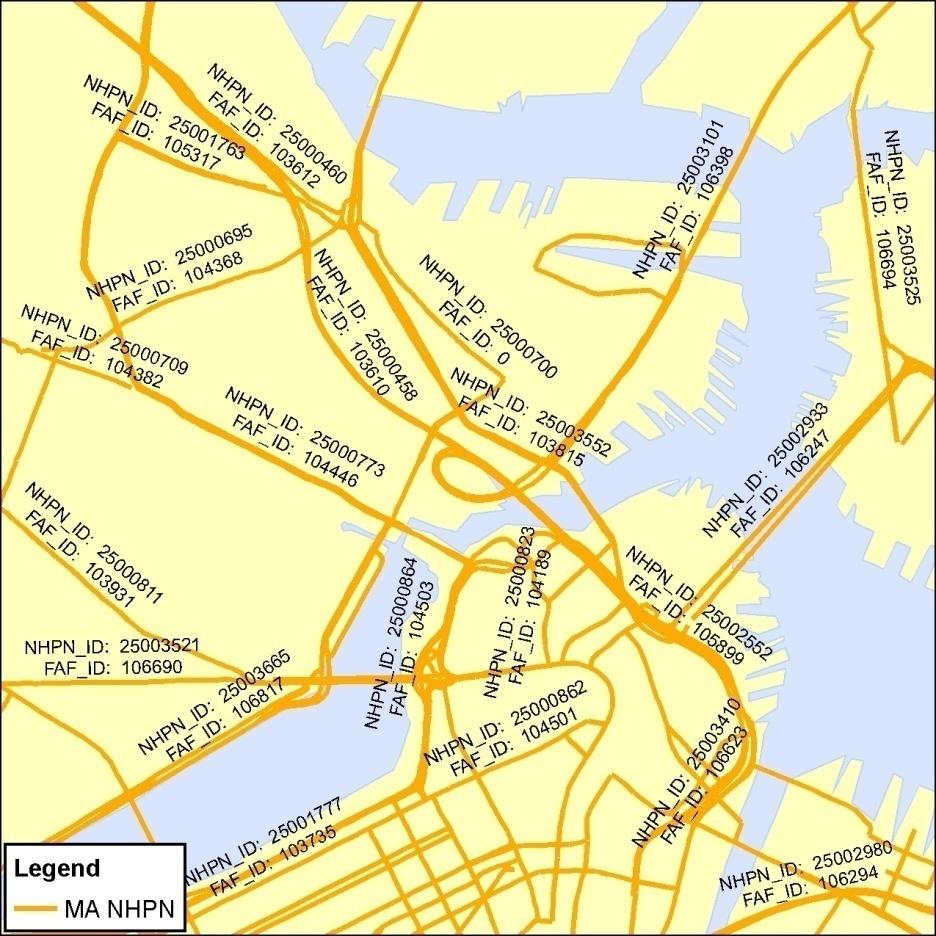
17 Step 3: Conflating NHPN
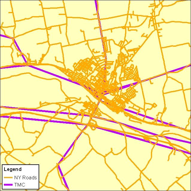
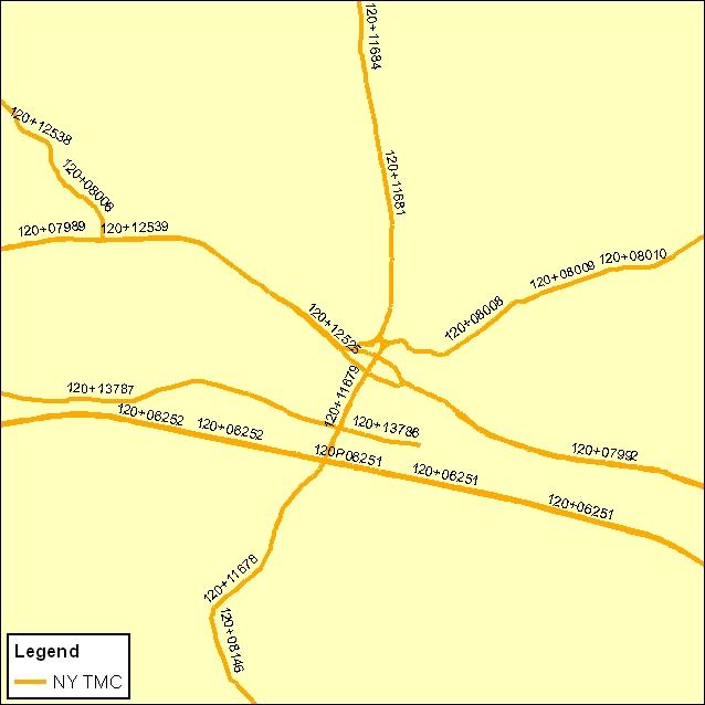
18 Step 3: Conflating TMCs
19 Step 4: QA/QC Manually check that all NHPN links are associated with a state road segment. Poor alignment of NHPN segments NHPN connectors missing from state network Unbuilt NHPN links missing from state network Select additional ICAT segments Non-NHPN arterial segments Freeway interchange ramps connecting ICAT segments Additional segments representing U.S. signed routes
20 Step 5: Extract ICAT Segments ICAT segments are flagged in the state road database using a supplemental field New state ICAT database is created from the flagged segments NHPN links for the state are removed from the hybrid ICAT network and replaced by the new state ICAT database

21 Step 6: Connecting at state borders Create points at borders where ICAT roads meet Automated process to "snap" ends to points
22 Prepare Outputs Automated process publishes datasets using a standard template Create Metadata Post shapefiles and geodatabases to FTP site Web-based data viewer

23 WebCAT Flex Viewer

24 WebCAT Flex Viewer
25 WebCAT Flex Viewer


26 Remaining Issues: Topology Several state networks not connected (not flowable) Solutions: Define GDB tolerance Run Clean process with user defined tolerance
27 Remaining Issues: Data Attributes: Some are not available Some are available but not attached to the road network Some are available, but through a different agency Metadata incomplete or non-existent NHPN is several years old (but currently being updated) Some TMCs require some manual code assignments


28 Remaining Issues: Crossing Borders Border connections not always straight-forward Maintain "exception list" of problem areas so when new datasets are received, they can quickly be identified and resolved Dual Centerline Single Centerline Same road represented in both state networks
29 Ideal State Network Characteristics Topologically connected All Roads database Includes local roads and interchange ramps Road segments split at intersections and gore points Divided roadways represented by separate segments State LRS built on top of All Roads database No need to conflate separate road geometries HPMS segments defined using State LRS Straightforward crosswalk between HPMS attributes and State road inventory attributes
30 Keys to ICAT Success Automated Processes Provide consistency, repeatability Use of domains in GDB accommodate code changes Up-front effort = less maintenance/update effort Documentation Written description of processes used Any "issues" with specific datasets States contacts, GIS websites, data dictionaries/metadata Feedback mechanisms
31 In Closing Acknowledgements State DOTs and GIS Staff I-95 Corridor Coalition: Contact Information: Questions or Comments?
SHIFT ODME Model & Utilities. Prepared For: Institute for Trade and Transportation Studies
 SHIFT ODME Model & Utilities Prepared For: Institute for Trade and Transportation Studies Developed January 2016 Updated February 2017 Table of Contents Section 1 Introduction... 1-1 1.1 Purpose of Model...
Using GIS to Analyze Crash Data in the I-95 Corridor
 Using GIS to Analyze Crash Data in the I-95 Corridor presented to GIS-T Symposium 2008 presented by Bruce D. Spear Cambridge Systematics, Inc. March 18, 2008 Transportation leadership you can trust. Presentation
Updating Virginia s Statewide Functional. Brad Shelton, VDOT Chris Detmer, VDOT Ben Mannell, VDOT
 Updating Virginia s Statewide Functional Classification System Brad Shelton, VDOT Chris Detmer, VDOT Ben Mannell, VDOT July 18, 2013 What is Functional Classification Use of Functional Classification Today
NATMEC June 30, 2014 Anita Vandervalk, PE, PMP
 NATMEC June 30, 2014 Anita Vandervalk, PE, PMP Agenda 1. Florida s MPM Program 2. Research Efforts and Progress 3. Source Book 4. Transitioning to Real Time Data 5. Next Steps Importance of Mobility Providing
Overview of the Draft Highway Primary Freight Network. November 20, :00 2:30 pm ET Coral Torres Ed Strocko
 Overview of the Draft Highway Primary Freight Network November 20, 2013 1:00 2:30 pm ET Coral Torres Ed Strocko 1 MAP-21 Language for Designation of National Freight Network In general: The Secretary shall
NYSDOT Roadway Inventory. Both On and Off the State System
 NYSDOT Roadway Inventory Both On and Off the State System 1 2 NYSDOT Highway Data Services Bureau Highway Data Traffic Monitoring Pavement Data Inventory of public roads, incl. LHI Systems designations
MAP 21 Freight Provisions and Seaports
 MAP 21 Freight Provisions and Seaports September 20, 2012 American Association of Port Authorities 703.684.5700 www.aapa-ports.org 3 New Freight Eligibility in Core Highway Formula Programs Surface Transportation
TRANSPORTATION RESEARCH BOARD. Spatial Modeling for Highway Performance Monitoring System Data: Part 1. Tuesday, February 27, :00-4:00 PM ET
 TRANSPORTATION RESEARCH BOARD Spatial Modeling for Highway Performance Monitoring System Data: Part 1 Tuesday, February 27, 2018 2:00-4:00 PM ET The Transportation Research Board has met the standards
Traffic Data Quality Analysis. James Sturrock, PE, PTOE, FHWA Resource Center Operations Team
 Traffic Analysis James Sturrock, PE, PTOE, FHWA Resource Center Operations Team Source Material Traffic Measurement http://ntl.bts.gov/lib/jpodocs/repts_te/14058.htm Seven DEADLY Misconceptions about Information
Estimating Freight Activity on Major Highways with the Freight Analysis Framework (FAF)
") Bureau of Transportation Statistics Estimating Freight Activity on Major Highways with the Freight Analysis Framework (FAF) Geospatial Interest Group of the Federal Committee on Statistical Methodology
Bureau of Transportation Statistics Estimating Freight Activity on Major Highways with the Freight Analysis Framework (FAF) Geospatial Interest Group of the Federal Committee on Statistical Methodology
Appendix D: Functional Classification Criteria and Characteristics, and MnDOT Access Guidance
 APPENDICES Appendix D: Functional Classification Criteria and Characteristics, and MnDOT Access Guidance D.1 Functional classification identifies the role a highway or street plays in the transportation
What is the Dakota County Principal Arterial Study?
 What is the Dakota County Principal Arterial Study? The Dakota County is underway and will address future designations of certain highways as Principal Arterials. What Are Principal Arterials? Principal
Model Characteristics
 1 General Model Design Highway Network/Traffic Analysis Zones (TAZs) Development of Synthetic Trip Tables Validation Procedures & Results Model Application (2003 & 2030) Review 2 Model Characteristics
Process to Identify High Priority Corridors for Access Management Near Large Urban Areas in Iowa Using Spatial Data
 Process to Identify High Priority Corridors for Access Management Near Large Urban Areas in Iowa Using Spatial Data David J. Plazak and Reginald R. Souleyrette Center for Transportation Research and Education
Appendix D Functional Classification Criteria and Characteristics, and MnDOT Access Guidance
 Appendix D Functional Classification Criteria and Characteristics, and MnDOT Access Guidance Functional classification identifies the role a highway or street plays in the transportation system. Some highways
Updating Virginia s Statewide Functional Classification System. Briefing to MPOs, PDCs, and Local Governments
 Updating Virginia s Statewide Functional Classification System Briefing to MPOs, PDCs, and Local Governments October 15 & 19, 2012 Functional Class 101 Shelton s FC Game Research Phase Today s Review New
RIDOT S Statewide Roadway and Asset Data Collection Project
 RIDOT S Statewide Roadway and Asset Data Collection Project ESRI User Conference 2017 Rafiq Basaria, DTS; Daniel Behnke DTS, Shane White, RIDOT Accent image here Primary Image here What is MIRE? Recommended
SHIFT Model Training: Scenario 5A
 SHIFT Model Training: Scenario 5A ITTS Freight in the Southeast Conference 2017 Liza Amar February 15 th 2017 Overview SHIFT Model Scope Model Scenario Examples Coding the Scenario Running the Model Evaluating
ACTION TRANSMITTAL
 ACTION TRANSMITTAL 2016-07 DATE: December 4, 2015 TO: FROM: TAC Planning MTS Staff PREPARED BY: Rachel Wiken (651) 602-1572 SUBJECT: REQUESTED ACTION: RECOMMENDED MOTION: Functional Class Change #1330
Florida Multimodal Statewide Freight Model
 Florida Multimodal Statewide Freight Model Model inputs and structure, and integration with regional truck-touring models Presented by Colin Smith, RSG Freight Issues in Florida Florida has a large, complex,
Software Development Status and The New Hampshire Proposal Tom Roff April 12,2010
 Software Development Status and The New Hampshire Proposal Tom Roff April 12,2010 HPMS Development Status Field Manual is out on the street. Screen Design is complete Developers are staffed up and coding
Regional Transportation Profile Guidelines. final. report. April tpd.azdot.gov
 final report April 2005 tpd.azdot.gov Regional Transportation Profile Guidelines Arizona Department of Transportation Transportation Planning Division April 2005 Table of Contents 1.0 Introduction... 1-1
Multimodal Freight Transportation Policy Overview
 Multimodal Freight Transportation Policy Overview Tiffany Julien U.S. Department of Transportation Federal Highway Administration Transportation Specialist Tiffany.julien@dot.gov Fixing America s Surface
SHIFT Model Training: Scenario 3A
 SHIFT Model Training: Scenario 3A ITTS Freight in the Southeast Conference 2017 Liza Amar February 15 th 2017 Overview SHIFT Model Scope Model Scenario Examples Coding the Scenario Running the Model Evaluating
Congestion Management Process (CMP)
") Congestion Management Process (CMP) Introduction The Congestion Management Process (CMP) is a systematic, data-driven, and regionally accepted approach that aims to improve the performance of the transportation
Congestion Management Process (CMP) Introduction The Congestion Management Process (CMP) is a systematic, data-driven, and regionally accepted approach that aims to improve the performance of the transportation
Functional Classification Comprehensive Guide. Prepared by
 Functional Classification Comprehensive Guide Prepared by June 6, 2014 INTRODUCTION PURPOSE OF DOCUMENT The intent of this document is to provide a comprehensive guide to Virginia Department of Transportation
NC State Freight Plan
 NC State Freight Plan NCARPO Quarterly Meeting January 26, 2017 Agenda NC Freight Tool Freight System Designation Update on Schedule and Tasks Next Steps 1 NC FREIGHT TOOL NC Freight Tool Overview Based
One Maryland One Centerline. GIS-T 2014 May 7, 2014
 One Maryland One Centerline GIS-T 2014 May 7, 2014 Current Road Centerlines in Maryland SHA maintains a statewide centerline Supports HPMS program Represents state and local roads Capturing dual carriageways
NCHRP Report 687 Guidelines for Ramp and Interchange Spacing
 Updates on NCHRP-Funded Geometric Design Research Projects NCHRP Report 687 Guidelines for Ramp and Interchange Spacing Brian L. Ray, PE Kittelson & Associates, Inc Portland, Oregon bray@ kittelson.com
6.0 CONGESTION HOT SPOT PROBLEM AND IMPROVEMENT TRAVEL DEMAND MODEL ANALYSIS
 6.0 CONGESTION HOT SPOT PROBLEM AND IMPROVEMENT TRAVEL DEMAND MODEL ANALYSIS 6.1 MODEL RUN SUMMARY NOTEBOOK The Model Run Summary Notebook (under separate cover) provides documentation of the multiple
Esri Roads and Highways An Introduction. Nathan Easley Rahul Rakshit
 Esri Roads and Highways An Introduction Nathan Easley Rahul Rakshit Roads and Highways Linear Referencing for the Transportation Enterprise GIS-enabled LRS platform LRS management LRS editing & maintenance
Central Data Repository for Traffic Data Collection in Rural Areas and Corridors Supporting Freight Mobility
 Central Data Repository for Traffic Data Collection in Rural Areas and Corridors Supporting Freight Mobility Tuesday, October 23, 2018 Michael Wieck International Road Dynamics Starting Point Technology
Statewide All Roads Layer Michigan Geographic Framework Field Definitions
 Statewide All Roads Layer Michigan Geographic Framework Field Definitions (Shapefile Attribute Table) (June 27, 2011 Version 11a) The following field definitions make up the shapefile attribute table called
MOBILITY AND ALTERNATIVES ANALYSIS
 6 MOBILITY AND ALTERNATIVES ANALYSIS BACK OF SECTION DIVIDER 6.0 Mobility and Alternatives Analysis Travel demand analysis provides a framework for the identification of transportation facilities and services
AMPO Annual Conference Session: Performance (Part 1) October 18, 2017 Savannah, GA
 October 18, 2017 Savannah, GA") AMPO Annual Conference Session: Performance (Part 1) October 18, 2017 Savannah, GA Introduction: North Jersey Transportation Planning Authority NJTPA Congestion Management Process Study Goals Analysis
AMPO Annual Conference Session: Performance (Part 1) October 18, 2017 Savannah, GA Introduction: North Jersey Transportation Planning Authority NJTPA Congestion Management Process Study Goals Analysis
Office of Transportation Data (OTD)
") Office of Transportation Data (OTD) Paul Tanner State Transp o rtatio n D ata A d m inistrato r Presentation Objectives Why do we collect data? State & Federal Code Requirements Who collects the data?
Office of Transportation Data (OTD) Paul Tanner State Transp o rtatio n D ata A d m inistrato r Presentation Objectives Why do we collect data? State & Federal Code Requirements Who collects the data?
CHAPTER 5. City of Greensburg Comprehensive Plan. Introduction. Transportation Goals & Objectives
 CHAPTER 5 TRANSPORTATION Introduction The transportation system forms the backbone of the community. I-74 provides the community with connections to larger metropolitan areas such as Indianapolis and Cincinnati.
TRANSPORTATION RESEARCH BOARD. Spatial Modeling for Highway Performance Monitoring System Data: Part 2. Tuesday, March 6, :00-3:00 PM ET
 TRANSPORTATION RESEARCH BOARD Spatial Modeling for Highway Performance Monitoring System Data: Part 2 Tuesday, March 6, 2018 1:00-3:00 PM ET The Transportation Research Board has met the standards and
RIDOT S Statewide Roadway and Asset Data Collection Project
 RIDOT S Statewide Roadway and Asset Data Collection Project GIS-T Conference 2017 Shane White Rhode Island DOT; Daniel Behnke DTS Accent image here Primary Image here RDIP Technical Assistance Started
NCHRP 3-88 Guidelines for Ramp and Interchange Spacing
 Session 312 Updates on NCHRP-Funded Geometric Design Research Projects NCHRP 3-88 Guidelines for Ramp and Interchange Spacing Brian L. Ray, PE Kittelson & Associates, Inc Portland, Oregon bray@ kittelson.com
Modeling Applications for Freight Tennessee DOT Freight Planning
 Modeling Applications for Freight Tennessee DOT Freight Planning presented to Tennessee Model Users Group presented by Dike Ahanotu Cambridge Systematics, Inc. July 17, 2008 Transportation leadership you
All Roads Layer Michigan Geographic Framework Field Definitions
 All Roads Layer Michigan Geographic Framework Field Definitions (Shapefile Attribute Table) (June 16, 2005 Version 5a) The following field definitions make up the shapefile attribute table called All Roads.
Freight Transportation Planning and Modeling Spring 2012
 Freight Model Validation Techniques Abstract Several reviews of validation techniques for statewide passenger and freight models have been published over the past several years. In this paper I synthesize
Wisconsin Statewide Model
 Wisconsin Statewide Model Outline of a Proposed Approach presented by Kimon Proussaloglou Cambridge Systematics, Inc. January 12, 2004 Project Team Wisconsin DOT Doug Dalton, Project Manager Don Uelmen,
LOUISIANA DOTD TRAFFIC MONITORING/DATA COLLECTION PROGRAM & UPDATES
 LOUISIANA DOTD TRAFFIC MONITORING/DATA COLLECTION PROGRAM & UPDATES George Chike, P.E. Traffic Data Collection & Management System www.dotd.la.gov DOTD FIELD CREWS Routine traffic volume counts Vehicle
MAP-21 themes. Strengthens America s highway and public transportation systems. Creates jobs and supports economic growth
 MAP-21 themes Strengthens America s highway and public transportation systems Creates jobs and supports economic growth Supports the Department s aggressive safety agenda Simplifies and focuses the Federal
FEDERAL HIGHWAY ADMINISTRATION ALL PUBLIC ROAD GEOSPATIAL REPRESENTATIVE STUDY
 FEDERAL HIGHWAY ADMINISTRATION ALL PUBLIC ROAD GEOSPATIAL REPRESENTATIVE STUDY Project Overview Project Introduction On August 7, 2012, FHWA announced that the HPMS is expanding the requirement for State
TEXAS FREIGHT MOBILITY PLAN 2017
 TEXAS FREIGHT MOBILITY PLAN 2017 Texas Transportation Commission September 28, 2017 Overview of the Texas Freight Mobility Plan 2016 Plan First multimodal freight mobility plan Identified freight network,
PROJECTS. The KIPDA MPO s Central Location
 PROJECTS Freight The economy of the Louisville KY-IN) Metropolitan Planning Area MPA), similar to that of the United States as a whole, is largely dependent on the efficient, reliable, and safe movement
Crystal Jones. Office of Freight Management and Operations. USDOT Federal Highway Administration
 Crystal Jones Office of Freight Management and Operations USDOT Federal Highway Administration September 2007 Context 25% of the U.S. GDP is related to international trade and is predicted to grow to 35%
Chapter 5 Transportation Draft
 Chapter 5 Transportation Draft Discussion Similar to the other elements in the Comprehensive Plan, the transportation element impacts the quality of life, economic development and public safety of the
Florida s Approach to Maximizing Advances in Data and Technology for Performance Management
 Florida s Approach to Maximizing Advances in Data and Technology for Performance Management June 2, 2015 Topics 1. Florida s MPM Program 2. Data needs and sources 3. Use of measured data vs modeled 4.
Assembling MIRE Data. The Vermont Experience. Vermont Agency of Transportation (VTrans) Mapping Section
 Mapping Section") Assembling MIRE Data The Vermont Experience A look into the development of GIS-based intersection data Vermont Agency of Transportation (VTrans) Mapping Section March 20, 2018 Embarking on the Task of
Assembling MIRE Data The Vermont Experience A look into the development of GIS-based intersection data Vermont Agency of Transportation (VTrans) Mapping Section March 20, 2018 Embarking on the Task of
Identifying, Anticipating, and Mitigating Freight Bottlenecks on Alabama Interstates
 Identifying, Anticipating, and Mitigating Freight Bottlenecks on Alabama Interstates By Mr. Kenneth Anderson, Dr. Steven Jones, and Dr. Jay Lindly Department of Civil, Construction, and Environmental Engineering
New Mexico Statewide Model
 New Mexico Statewide Model Fifth Largest State in land area 2005 Population 1.97 million 42% of state in Albuquerque and Santa Fe area Outside urban areas population density very low New Mexico Planning
MINNESOTA. Jurisdictional Realignment Project Final Report
 MINNESOTA Jurisdictional Realignment Project Final Report November 2012 Table of Contents Executive Summary... 1 Objective... 1 Approach... 1 Prior studies... 2 Phase 1 Assigning the right roads to the
VEHICLE PARTICULATE EMISSIONS ANALYSIS
 VEHICLE PARTICULATE EMISSIONS ANALYSIS Prepared for ARIZONA DEPARTMENT OF TRANSPORTATION TRANSPORTATION PLANNING DIVISION MPOs/COGs AIR QUALITY POLICY AND LOCAL PROGRAMS SECTION AND YUMA METROPOLITAN PLANNING
FUNCTIONAL CLASSIFICATION PROCESS
 FUNCTIONAL CLASSIFICATION PROCESS Roadway Functional Classification System Functional classification is the process by which the local, state and nation s street and highway network is ranked according
Technical Memorandum MULTIMODAL NEEDS. Prepared for: Oklahoma Department of Transportation. Prepared by:
 Technical Memorandum MULTIMODAL NEEDS Prepared for: Oklahoma Department of Transportation Prepared by: May 2015 Technical Memorandum The Technical Memos were written to document early research for the
9. TRAVEL FORECAST MODEL DEVELOPMENT
 9. TRAVEL FORECAST MODEL DEVELOPMENT To examine the existing transportation system and accurately predict impacts of future growth, a travel demand model is necessary. A travel demand model is a computer
FHWA Programs Supporting Freight
 FHWA Programs Supporting Freight Institute for Trade and Transportation Studies Conference Office of Operations 1200 New Jersey Avenue S.E. Washington, D.C. 20590 www.ops.fhwa.dot.gov/freight Jeff Purdy,
Transportation Model Report
 1. Introduction The traffic impacts of the future developments in the IL130/High Cross Road corridor for different scenarios were analyzed using a Travel Demand Model (TDM). A four step modeling process
FHWA URBAN BOUNDARY and FEDERAL FUNCTIONAL CLASSIFICATION HANDBOOK
 FHWA URBAN BOUNDARY and FEDERAL FUNCTIONAL CLASSIFICATION HANDBOOK Transportation Statistics Office Florida Department of Transportation Tallahassee, Florida April 4, 2003 FHWA Urban Boundary and Federal
MAP-21 Freight Provisions and Data Needs
 MAP-21 Freight Provisions and Data Needs Does understanding the big picture matter? Will imports/exports go up or down in 10 years? Where will people live in ten/twenty/thirty years? Where will the state
Highway and Freight Current Investment Direction and Plan. TAC August 2, 2017
 Highway and Freight Current Investment Direction and Plan TAC August 2, 2017 Today s Topics Highway & Freight Where are we now? The Highway Story What are the issues? How is the system performing? Where
Interactive Data Visualization Tools for Travel Demand Model Datasets. Shuyao Hong
 Interactive Data Visualization Tools for Travel Demand Model Datasets Shuyao Hong GIS-T Symposium Phoenix, Arizona April 10-13, 2017 MAG Modeling Area Area: 16,080 Square Miles Population: 4.9 Million
Final Report. Improving Mobility Information with Better Data and Estimation Procedures
 Improving the Quality of Life by Enhancing Mobility University Transportation Center for Mobility DOT Grant No. DTRT06-G-0044 Improving Mobility Information with Better Data and Estimation Procedures Final
APPENDIX H: TRAVEL DEMAND MODEL VALIDATION AND ANALYSIS
 APPENDIX H: TRAVEL DEMAND MODEL VALIDATION AND ANALYSIS Travel demand models (TDM) simulate current travel conditions and forecast future travel patterns and conditions based on planned system improvements
New Jersey Congestion Management System
 New Jersey Congestion Management System - Proposed System Update - Presentation to the ISIB Prepared by: Bureau of Systems Planning April 15, 2008 ~ Commissioner s Conference Room ~ 1:30 PM Today s Objective
report final Decennial Model Update Executive Summary Contra Costa Transportation Authority Cambridge Systematics, Inc.
 final report prepared for Contra Costa Transportation Authority prepared by with Dowling Associates Caliper Corporation June 2003 Table of Contents 1.0 Introduction... ES-1 2.0 Data Development... ES-5
Standardization of Travel Demand Models
 Standardization of Travel Demand Models TNMUG Meeting November 14, 2013 The North Carolina Experience Leta F. Huntsinger, Ph.D., P.E. and Rhett Fussell, P.E. Background } North Carolina Profile } 18 MPOs,
The Policies section will also provide guidance and short range policies in order to accomplish the goals and objectives.
 4 Goals & Objectives INTRODUCTION The 2015-2040 MTP preserves and promotes the quality of life and economic prosperity of the MAB by providing a transportation system consistent with the regional goals.
Regional Transportation Performance Measures
 Regional Transportation Performance Measures March 5, 2014 Presented by Tom Murtha Regional Transportation Performance 2 Measures: Introduction Regional Transportation Performance Measures address needs
Proposed Comprehensive Update to the State of Rhode Island s Congestion Management Process
 Proposed Comprehensive Update to the State of Rhode Island s Statewide Planning Program January 2018 Summary Outline of of Action Steps 1. Develop Objectives for Congestion Management What is the desired
Using INRIX Data in Iowa. Kyle Barichello, Iowa DOT Skylar Knickerbocker, InTrans
 Using INRIX Data in Iowa Kyle Barichello, Iowa DOT Skylar Knickerbocker, InTrans What is probe data? What is INRIX data? INRIX Data Overview Purchased traffic data Covers Interstates, State Highway, some
ACTION TRANSMITTAL
 Transportation Advisory Board of the Metropolitan Council of the Twin Cities ACTION TRANSMITTAL 2018-17 DATE: January 25, 2018 TO: FROM: Technical Advisory Committee - Planning Metropolitan Transportation
Esri Roads and Highways An Introduction
 Esri International User Conference San Diego, California Technical Workshops July 24, 2012 Esri Roads and Highways An Introduction William Isley Majunu Seran Agenda Product Overview Desktop - Demo: Network
Recommended Roadway Plan Section 3 Existing Facilities & System Performance
 Recommended Roadway Plan Section 3 Existing Facilities & System Performance RECOMMENDED ROADWAY PLAN SECTION 3 Existing Facilities and System Performance 3.1 Introduction An important prerequisite to transportation
INDIANA S INTERMODAL MANAGEMENT SYSTEM Stephen C. Smith Planning Manager, Transportation Planning Division Indiana Department of Transportation
 96 INDIANA S INTERMODAL MANAGEMENT SYSTEM Stephen C. Smith Planning Manager, Transportation Planning Division Indiana Department of Transportation Indiana is in the process of developing an Intermodal
Virginia Critical Rural and Urban Freight Corridor Designation WebEx Discussion. September 28, 2017, 10:30 12:00
 Virginia Critical Rural and Urban Freight Corridor Designation WebEx Discussion September 28, 2017, 10:30 12:00 Agenda Introductions Purpose National Highway Freight Network Eligibility requirements Data
HB2 Implementation Policy Guide
 report HB2 Implementation Policy Guide prepared for Commonwealth Transportation Board date August 1, 2015 6.0 Appendix A: Safety Measures Table 6.1 Safety Factor Measures Summary ID Measure Name Weight
FLORIDA DEPARTMENT OF TRANSPORTATION PROCEDURE DEVELOPMENT OF THE
 FLORIDA DEPARTMENT OF TRANSPORTATION PROCEDURE DEVELOPMENT OF THE FLORIDA INTRASTATE HIGHWAY SYSTEM Topic No.: 525-030-250-f Office: Systems Planning Effective Date: May 16, 2002 DEVELOPMENT OF THE FLORIDA
Adaptation of HERS-ST Models for the South Carolina Interactive Interstate Management System
 Adaptation of HERS-ST Models for the South Carolina Interactive Interstate Management System presented to the Transportation Research Board HERS Modeling and Data Integration Conference presented by William
Freight Trends and Freight Rail
 Freight Trends and Freight Rail presented to Delaware Valley Goods Movement Task Force 10 th Anniversary Meeting Philadelphia presented by Lance R. Grenzeback Cambridge Systematics, Inc. October 9, 2002
Highway and Freight Current Investment Direction and Plan. TAB September 20, 2017
 Highway and Freight Current Investment Direction and Plan TAB September 20, 2017 Today s Topics Where are we now, what are the current issues? Where do we want to go? How will we get there? What are the
HCM 6th Edition Planning and Preliminary Engineering Applications Guide (PPEAG) to the HCM Bringing Back-of-the-Envelope Back.
 to the HCM Bringing Back-of-the-Envelope Back.") HCM 6th Edition Planning and Preliminary Engineering Applications Guide (PPEAG) to the HCM Bringing Back-of-the-Envelope Back April, 2017 Potential Use of the HCM in Planning The HCM is commonly used to
HCM 6th Edition Planning and Preliminary Engineering Applications Guide (PPEAG) to the HCM Bringing Back-of-the-Envelope Back April, 2017 Potential Use of the HCM in Planning The HCM is commonly used to
CHAPTER 7. TRAVEL PATTERNS AND TRAVEL FORECASTING
 CHAPTER 7. TRAVEL PATTERNS AND TRAVEL FORECASTING TRAVEL PATTERNS Northwest Arkansas has experienced unprecedented growth in population and employment in the past 25 years. The economic vitality and diversity
Integrating MAP-21 Asset Management Data Using Esri s Roads and Highways. Imagine the result
 Integrating MAP-21 Asset Management Data Using Esri s Roads and Highways Imagine the result 1 17 2012 October ARCADIS 2014 Presenters David Ward Project Manger and Principal Architect for AzDOT Roads and
A Time Series Approach to Forecast Highway Peak Period Spreading and Its Application in Travel Demand Modeling
 A Time Series Approach to Forecast Highway Peak Period Spreading and Its Application in Travel Demand Modeling Sabya Mishra (University of Memphis) Timothy F. Welch (Georgia Institute of Technology) Subrat
Chapter #9 TRAVEL DEMAND MODEL
 Chapter #9 TRAVEL DEMAND MODEL TABLE OF CONTENTS 9.0 Travel Demand Model...9-1 9.1 Introduction...9-1 9.2 Overview...9-1 9.2.1 Study Area...9-1 9.2.2 Travel Demand Modeling Process...9-3 9.3 The Memphis
REQUIREMENTS WEBINAR FEBRUARY 20, :00 2:30 P.M.
 ENHANCED NATIONAL HIGHWAY SYSTEM AND REQUIREMENTS WEBINAR FEBRUARY 20, 2013 1:00 2:30 P.M. Webinar Housekeeping Tips There is a designated time at the end of the presentation for questions and answers.
Automated Statewide Highway Intersection Safety Data Collection and Evaluation Strategy
 Automated Statewide Highway Intersection Safety Data Collection and Evaluation Strategy Fan Yang, Ph.D. Candidate Department of Civil and Environmental Engineering, University of Wisconsin-Madison, Madison,
IDENTIFYING, ANTICIPATING, AND MITIGATING FREIGHT BOTTLENECKS ON ALABAMA INTERSTATES KENNETH MICHAEL ANDERSON
 IDENTIFYING, ANTICIPATING, AND MITIGATING FREIGHT BOTTLENECKS ON ALABAMA INTERSTATES by KENNETH MICHAEL ANDERSON DR. JAY LINDLY, COMMITTEE CHAIR DR. STEVEN JONES DR. JOE WEBER A THESIS Submitted in partial
Project Title: Using Truck GPS Data for Freight Performance Analysis in the Twin Cities Metro Area Prepared by: Chen-Fu Liao (PI) Task Due: 12/31/2013
 Task Due: 12/31/2013") Project Title: Using Truck GPS Data for Freight Performance Analysis in the Twin Cities Metro Area Prepared by: Chen-Fu Liao (PI) Task Due: 12/31/2013 TASK #5: IDENTIFY FREIGHT NODE, FREIGHT SIGNIFICANT
Project Title: Using Truck GPS Data for Freight Performance Analysis in the Twin Cities Metro Area Prepared by: Chen-Fu Liao (PI) Task Due: 12/31/2013 TASK #5: IDENTIFY FREIGHT NODE, FREIGHT SIGNIFICANT
2040 Addendum Performance-Based Planning November 2018
 2040 Long Range Transportation Plan 2040 Addendum Performance-Based Planning November 2018 Adopted June 13, 2018 250 S. Orange Ave, Suite 200, Orlando, FL 32801 407-481-5672 www.metroplanorlando.org MetroPlan
TRANSPORTATION PROJECT REPORT DRAFT CONCEPTUAL ACCESS MODIFICATION PROPOSAL OCTOBER 2002
 TRANSPORTATION INTERSTATE 87 INTERCHANGE 11A TOWN OF MALTA SARATOGA COUNTY, NY DRAFT CONCEPTUAL ACCESS MODIFICATION PROPOSAL OCTOBER 2002 PROJECT REPORT NEW YORK STATE DEPARTMENT OF TRANSPORTATION JOSEPH
SECTION 5. Existing Conditions TRANSPORTATION NETWORK TRANSPORTATION
 SECTION 5 TRANSPORTATION Transportation systems are vital for moving people and goods and serving existing businesses. They also play a major role in guiding the location and type of development. The following
Presented by John Hudler Geospatial Group Leader Office of Transportation Data Georgia Department of Transportation
 Presented by John Hudler Geospatial Group Leader Office of Transportation Data Georgia Department of Transportation Collection, Quality Assurance and Reporting of the States roadway and transportation
New Jersey Pilot Study
 New Jersey Pilot Study Testing Potential MAP-21 System Performance Measures for Two Corridors Executive Summary October 2014 ABOUT THE NJTPA THE NJTPA IS THE FEDERALLY AUTHORIZED Metropolitan Planning
MULTIMODAL NETWORK ANALYSIS FOR COAL FREIGHT IN KENTUCKY SESSION 6.2.3
 MULTIMODAL NETWORK ANALYSIS FOR COAL FREIGHT IN KENTUCKY SESSION 6.2.3 John Ripy, GISP, CISSP, Senior Investigator Ted Grossardt, PhD, Research Program Manager Ben Blandford, ABD, Research Investigator