St. Augustine Multimodal Transportation Center Study
|
|
|
- Philomena Bell
- 5 years ago
- Views:
Transcription


1 St. Augustine Multimodal Transportation Center Study Expanding Mobility, Tourism, and Economic Development Public Workshop/Open House July 30 th, 2013
2 Tonight s Goals 1. Provide Project Overview & Deliverables 2. Review Site Selection Process (Suitability Analysis) 3. Review and Analyze Candidate Sites 4. Complete Open-Ended Feedback Survey regarding each site 5. Questions and Wrap Up


3 Contextual Framework Significant residential growth of County and region Previous Studies o o 2001 St. Augustine/St. Johns County Multi-Modal Transportation Center Study Amtrak/FEC Corridor Project Possible restoration of Amtrak service on FEC line Commuter Rail Feasibility (~2022) All Aboard Florida (~2014) 450 th Commemoration Emphasis on collaborative regional efforts such as ULI Reality Check, RTSC, and North Florida Freight, Logistics & Intermodal Framework Plan
4 Study Area St. Augustine Urbanized Area (2010 Census) o Includes St. Augustine, St. Augustine Beach, Vilano Beach, Crescent Beach, St. Augustine Shores, St. Augustine South and associated centers and infrastructure o Consistent with previous studies (focused) o Greater regional multimodal opportunities
5 What are the Project Deliverables? Summary Report consisting of: o Best Practices/Case Studies o Objective analysis based on measurable criteria and community-based outcomes Data and analysis will validate suitable location o Optimal site(s) for new multimodal center/station triggered by new mode of travel (i.e. intercity/commuter rail transit) (Ideally suited location for when these modes come into St. Augustine area, not necessarily a build it and they will come) o Multimodal activities, facility requirements, conceptual layout and implementation strategies o Potential mixed use and joint development opportunities around center/station sites (TOD)
6 Stakeholder Working Group Range of backgrounds, expertise from government officials, economic development experts, community activists, rail historians, etc. Establish a reasonable framework for public decision-making (6 potential locations) Tasked with overseeing process to ensure highest caliber of objectivity, identifying and weighing site selection criteria, and parcel evaluations

7 What Is A Multimodal Center? A center/station that includes multiple modes of transportation into one location facilitating safe and convenient transfer among them
8 Why Build One? Foundation for greater integration of future regional transportation services/connectivity which reduce congestion and enhance quality of life (CONNECTIVITY) Leverage investment to support revitalization efforts and create synergies that lead to other future investments (ECONOMIC DEVELOPMENT/TOURISM) The convergence of new locational/housing preferences, diverse household composition, declining automobile dependency (NEW MOBILITY CHOICES)
9 Economic and Tourism Development Every $1 spent on public transit projects generates on average $6 in local economic activity. (Source: American Public Transportation Association) Between 3,140 and 5,700 jobs are generally created for every $100 million invested in public transit. (Source: Cambridge Systematics, Inc.) Research shows that businesses realize a gain in sales of three times the public sector investment in transit; a $100 million transit investments results in a $300 million increase in business sales. (Source: Cambridge Systematics, Inc.)


10 Kenosha (WI) Trolley, 2 mile line; 69 acres Lake Michigan redevelopment Before: 2000 After: 2010 LYNX Charlotte: 9.6 miles; $1.87 billion in TOD along south corridor Before: 1998 After: 2010 Courtesy: MetroJacksonville.com


11 Decline in Driving Decline in driving and licensed drivers among Millenials Digital Revolution, Social Media, and Environmental Concerns


12 Millenials & Boomers Ideal Shift
13 Comments from 2010 FEC/Amtrak Study Station should reinforce The Nation s Oldest City & St Johns County as key tourist destination Ridership base also includes student population Year-round tourist activity warrants medium, staffed station Need to accommodate multi-modal activity (bus, trolley, car, bicycle/pedestrian, other) Station location should tie into future JTA commuter rail Location should allow riders to walk to some destinations Carrera site is closest point to historic downtown (King Street terminus) and may require lighted US1 interchange San Marco site is near northern end of historic district with existing FEC station Airport site is centrally located for County residents with plans for intermodal center Station should be as green as possible


 MOBILITY o")


14 Analysis Framework COMMUNITY o Population/Employment o Parcel Characteristics o Proximity to Destinations & Downtown (Tourism/Activity Centers) MOBILITY o Accessibility/Roadway Connectivity o Connectivity with other Existing Transportation (Rail, Transit & Air Service) o Bike/Pedestrian Access ENVIRONMENT o Environmental Constraints (Wetlands)
15 Criteria Weighting/Scoring Criteria (Community/Mobility/Environment) Quantitative/Spatial-Based Ranking of Candidate Zones Population/Employment Negative Neutral Positive Weighting Average Score 1,3,5 Zone is in remote location relative to population and employment Zone is proximate to Zone of dense population and employment Zone is within an dense Zone of population and employment 3.5 Comments -Tourism use brings in more money than local -Serve the greatest number of people -Consider future employment centers Ease of Access & Circulation Connectivity with other Existing Transportation Services (Bus/Air/Trolley) Bicycle/Pedestrian Accessibility Proximity to Destinations (Tourism/Activity Centers) Zone is in remote location that is distant from major roadway facilities and dense street network to promote adequate access and circulation Zone that is further than ½ mile from transit route and/or other modes of existing transportation Zone with no bicycle or pedestrian access Zone that is considerably distant (beyond 1 mile) from major tourism, shopping and commerce centers Parcel Size, Use and Availability Parcel(s) that are smaller than 35,000 square feet in total may be difficult to provide all of the multimodal facility requirements within the space. In addition, parcel(s) is currently in private ownership and generally residential in nature Zone is located either along major corridors or proximate to dense street network, but not both Zone that is between ½ mile and ¼ mile of transit route and/or other modes of existing transportation services Zone with pedestrian and bicycle access, but more than ½ mile to other activities Zone that is between 1 mile and ½ mile from major tourism, shopping and commerce centers Parcel(s) between 35,000 and 45,000 square feet could accommodate many of the multimodal facility requirements but may need more design to do so. In addition, parcel(s) is currently in private ownership, vacant and/or non-residential in nature Zone is located within major roadway facilities, dense street network and manageable parcel shapes to promote adequate access and circulation Zone within ¼ mile (the typical walking distance for transit) of transit route and/or other modes of existing transportation services Zone with good pedestrian and bicycle access and close (within ½ to ¼) to other activities Zone that is proximate to (within ½ mile of) major tourism, shopping and commerce centers Parcel(s) larger than 45,000 square feet can more easily fulfill the multimodal facility requirements and offer the potential for joint development agreements. In addition, parcel(s) is owned entirely by a public entity and generally vacant and/or non-residential in nature 4.8 -Look at future development that could occur around center -Should include funded projects -Parking is major consideration -Promotes ease of customer use 4.6 -Proximity to existing rail very important -Paramount -City vision=local interface; National/Airport Vision=Not so focused on local modes -Important but possible to create that connection -Rail access and consider connectivity to all lines, including Wilbur Wright Industrial Lead -Emphasis as a rail transit hub (esp with future commuter rail) 3.2 -Willing to trade walkable proximity for accessibility via trolley train, bus, car -Peds/Bikes important, but can be managed with other modal connectivity -Nice but not top priority -Less expensive to create this access -Easiest to improve in future Key to this transportation center; bringing money into community, as tourism is largest and fastest growing sector -A must to accomplish goal of being multimodal -Local transportation can get you to ultimate destination, more beneficial to not be in the heart of the center -Parcels should be public or private -Fewer parcels should rank higher than more parcels -Minimum and maximum limits and affordability -Single ownership to ease negotiations -Consider future expansion and TOD planning and private investment -Private business development; wholesale markets


16 Suitability Analysis CommunityViz Site Suitability Analysis o Process of determining which locations are best suited for certain uses Grid cells as suitability layer containing specific criteria Dynamically modify weighting of each and see results


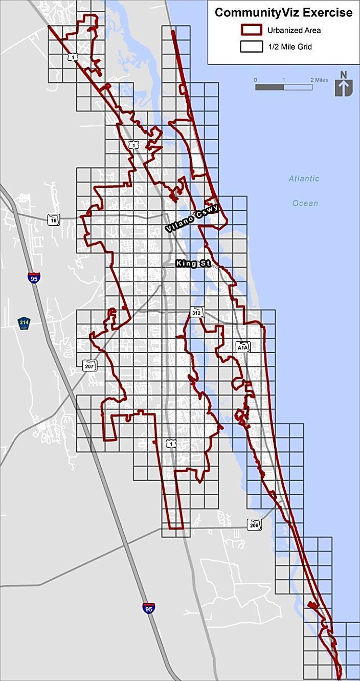
17 Process Illustration

18 Process Illustration Suitability Scoring Analysis Reveal ½ Mile Hot Spot Zones based on 75 or better scoring
19 Process Illustration Cluster Analysis of the Hot Spot Zones
20
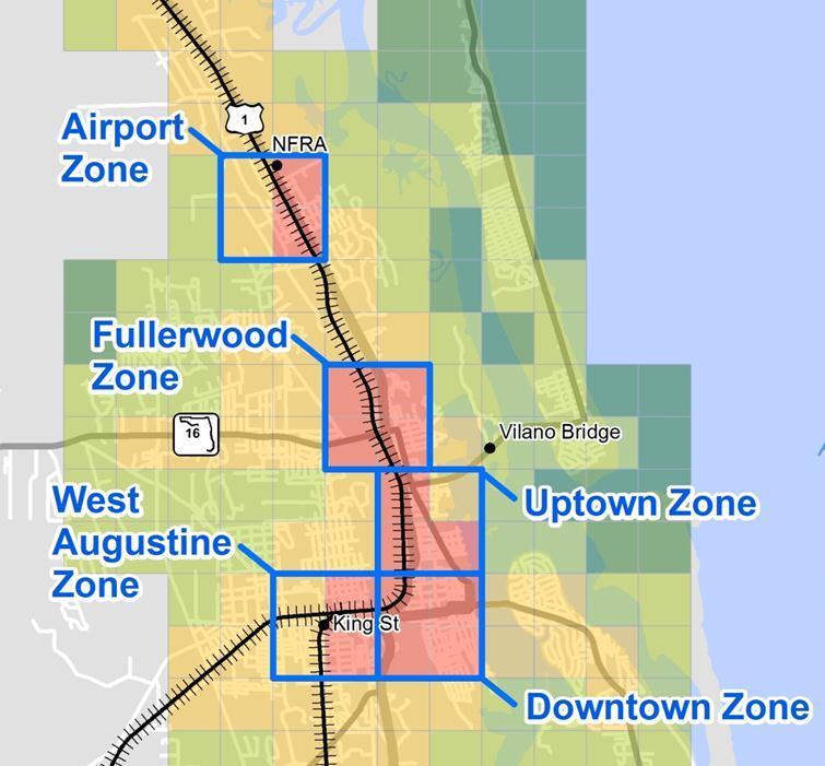
21 Airport Zone Hot Spot Zones further broken down into ¼ mile grids and filtered with criteria to focus on parcels Fullerwood Zone Uptown Zone West Augustine Zone Downtown Zone
22 Parcel Evaluation Parcels within the resulting ¼ mile grid cells further evaluated against the following criteria: o Adjacent to existing rail infrastructure o Connectivity with existing roadway infrastructure o Size at least 1 acre o Vacant/Underutilized property o Single Ownership o Minimal environmental impacts (wetlands) o Minimum Rail station design considerations for St. Augustine Context
23 Size Station Guidelines Heated Sq Feet Platform Length Minimum Annual Ridership Design & Service Features <1 Acre <1, ,000 Platform/Canopy/Signage/E Ticket Booth 1-5 Acres 5-10 Acres 2,500-5, ,000 Platform/Canopy/Vehicle Access and Wayfinding/Ticketing/Baggag e/passenger Information/Security ~10, ,000 All the Above/Rental Cars/Major Parking Requirements For Intercity rail, assumes a medium staffed station, with minimum 50K in annual ridership ( peak hour passengers) and $500K in annual revenue

 Multi-modal aspects include Bus, Bike/Ped, Kiss & Ride Complementary")
24 Rail Platform Rail Station Bus Drop-off Adjacent Parcel Development Opportunities Patron Parking Development Site Components Rail Platform can extend beyond site boundaries (RR R/W) Patron and Employee Parking (On or Off-site) Multi-modal aspects include Bus, Bike/Ped, Kiss & Ride Complementary Uses on Adjacent Parcels

")

25 Florida Station Examples Ft. Lauderdale 56,913 Passengers (2012) Kissimmee 48,521 Passengers (2012) Hollywood 38,805 Passengers (2012)

26 Identified Parcels within Zones


27 4.9 ac of ROW Zoned OR Existing bus transit connectivity within vicinity No hotels/activity centers within ¼ mi Site previously examined in 2001 and 2010 Site 1: Northeast Florida Regional Airport


28 7.2 ac/fec owned site 4000 sf existing bldg Zoned Commercial Along existing bus transit and bike facility Several shopping/activity centers, neighborhoods within ¼ mile Site previously examined in 2010 Amtrak/FEC Project Site 2: US 1/San Marco FEC Parcel


29 1.5 ac vacant Fountain of Youth parcel Zoned Commercial Along existing bus transit and bike facility Several shopping/activity centers, neighborhoods within ¼ mile Approx 520 hotel rooms within ¼ mile Site 3: US 1/Old Mission Avenue Parcel


30 2 acres of vacant FEC owned property Zoned Open Land Along existing bus transit and bike facility, walkable to historic district Several shopping/activity centers, neighborhoods within ¼ mile Site previously examined in 2010 Amtrak/FEC Corridor Project Site 4: Downtown US 1/Carrera St. Parcel

 Access via Depot St.")
31 Site 5: West Augustine Depot Street Parcel 3.1 acre vacant site owned by Broudy s Zoned I/W Along existing bus transit and bike facility, walkable to historic district (7 hotel rooms) Access via Depot St. Several vacant / underutilized parcels West Augustine CRA


32 Site 6: West Augustine Spur Parcel 3.1 acre vacant Countyowned site Zoned Res No existing bus transit service/bicycle facilities Several vacant / underutilized parcels West Augustine CRA Goals

33 Be Bold, Think BIG


34 Next Steps Synthesize comments and develop final recommendations and conceptual plan Final Stakeholder Working Group Meeting and Final Feasibility Report The desire to go to through a place must be balanced with the desire to go to a place.
Airports in the Region Case Study
 DESTINATION LINDBERGH: COLLABORATION AND VISION TO MEET SAN DIEGO S MOBILITY NEEDS By Bob Leiter, FAICP, Keith Wilschetz, and Tait Galloway INTRODuCTION Destination Lindbergh was a year-long, comprehensive
Transit Oriented Development Study
 Federal Way Link Extension Transit Oriented Development Study Table of Contents Executive Summary ES 1 Chapter 1: Introduction.. 1-1 Chapter 2: Methodology. 2-1 Chapter 3: Project Overview 3-1 Chapter
ACTIVE TRANSPORTATION ADVISORY COMMITTEE. Memphis MPO March 30, 2015
 ACTIVE TRANSPORTATION ADVISORY COMMITTEE Memphis MPO March 30, 2015 Agenda Welcome & Introductions Announcements and Briefings Livability 2040: Regional Transportation Plan Congestion Management Process
Summary of transportation-related goals and objectives from existing regional plans
 SMTC 2050 Long Range Transportation Plan Appendix A: Summary of transportation-related goals and objectives from existing regional plans SMTC 2050 Long Range Transportation Plan Summary of transportation-related
SOUTHWEST LRT (METRO GREEN LINE EXTENSION)
") 8 Evaluation of Alternatives This chapter evaluates the effectiveness of the No Build Alternative and the Southwest Light Rail Transit (LRT) Project (the Project) based on the information contained in
8 Evaluation of Alternatives This chapter evaluates the effectiveness of the No Build Alternative and the Southwest Light Rail Transit (LRT) Project (the Project) based on the information contained in
3 Documentation of Alternatives
 Sacramento Intermodal Transportation Facility TR #9 SITF Alternatives 3 Documentation of Alternatives This section documents the four alternative concept plans for the Sacramento Intermodal Transportation
This document has been developed to provide context to the Board as part of the strategic planning process. Regional development and travel trends
 1 This document has been developed to provide context to the Board as part of the strategic planning process. Regional development and travel trends and forecasts are provided, including population, employment,
3. STATION SPACING AND SITING GUIDELINES
 3. STATION SPACING AND SITING GUIDELINES The station spacing and siting guidelines are summarized in Table 3-1. Table 3-1 also includes benchmark information for local transit service and express bus as
Infrastructure and Growth Leadership Advisory Group Ideas and Approaches Survey
 Infrastructure and Growth Leadership Advisory Group Ideas and Approaches Survey Maintain transportation system in state of good repair 1. Increase focus on maintenance of existing infrastructure in poor
TRANSPORTATION RELATIONSHIP TO OTHER ELEMENTS OF THE PLAN AND COUNTY REGULATIONS VISION FOR TRANSPORTATION PLANNING ROAD NETWORK SECTION 7
 TRANSPORTATION Like many growing western counties, Douglas County focuses on one of the most integral elements in land-use planning: transportation. The primary purpose of a transportation network is to
2004 FEASIBILITY STUDY UPDATE
 Austin-San Antonio Intermunicipal Commuter Rail District 2004 FEASIBILITY STUDY UPDATE December 2004 EXECUTIVE SUMMARY INTRODUCTION Almost 3 million people in Central Texas, living and working between
North Side Transfer Zone. Public Open House April 16, 2014
 North Side Transfer Zone Public Open House Agenda Introductions Project Background and Purpose Transit Zone Components Site Identification Concepts Open Discussion 2 Project Purpose To determine the feasibility
Chapter 3 Stakeholder Interviews and Summary of Needs
 Chapter 3 Stakeholder Interviews and Summary of Needs 42 CHAPTER 3 STAKEHOLDER INTERVIEWS AND SUMMARY OF NEEDS CHAPTER 3. STAKEHOLDER INTERVIEWS AND SUMMARY OF NEEDS An extensive stakeholder interview
SOUTHEAST FLORIDA REGIONAL COMPACT CLIMATE CHANGE. Sustainable Communities & Transportation Planning
 SOUTHEAST FLORIDA REGIONAL COMPACT CLIMATE CHANGE Draft Regional Climate Action Plan Sustainable Communities & Transportation Planning SP-1 Develop criteria in collaboration with municipal and county planning
NEW OPPORTUNITY FOR MIDDLESEX COUNTY
 Source: http://www.flickr.com/photos/scraparcs/3259040067/sizes/l/in/photostream/ RARITAN RIVER LIGHT RAIL NEW OPPORTUNITY FOR MIDDLESEX COUNTY This report studies the viability of a new transit line connecting
1. Evaluation of route and service alternatives; 2. Tier 1 Environmental Impact Analysis; and 3. Service Development Plan.
 Rail Rail plays a significant role in transportation planning, especially when considering economic development, safety, freight, and intermodal connectivity. Jackson has two rail lines serving the area,
GULF COAST RAIL DISTRICT VISION FOR REGIONAL RAIL
 GULF COAST RAIL DISTRICT VISION FOR REGIONAL RAIL OCTOBER 2014 Cover photographs courtesy of Top left - Mike Bates TABLE OF CONTENTS MISSION... 1 INTRODUCTION... 1 VISION STATEMENT... 1 BACKGROUND... 2
Site Criteria Evaluation Matrix
 FILED FOR RECORD 2/16/2016 9:00 AM Dana Debeauvoir - County Clerk, Travis County,TX Item 12 - ADDITIONAL Site Criteria Evaluation Matrix Belinda Powell, Travis County, ED&SI Matias Segura and Jerimi Henry,
Contents i Contents Page 1 A New Transportation Plan Community Involvement Goals and Objectives... 11
 Contents i Contents 1 A New Transportation Plan... 1 Why develop a new plan?... 1 What area does the LRTP focus on?... 2 Why is this LRTP important?... 3 Meeting Requirements for Transportation Planning...
2040 Transportation Policy Plan Conversion to Performance Based Planning Basis. 25 th Annual CTS Transportation Research Conference May 21, 2014
 2040 Transportation Policy Plan Conversion to Performance Based Planning Basis 25 th Annual CTS Transportation Research Conference May 21, 2014 1 About the plan Long-range transportation plan for the Twin
APPENDIX B - GLOSSARY FEBRUARY 2017
 APPENDIX B - GLOSSARY FEBRUARY 2017 DENVERMOVES Transit Denver Moves: Transit - ii - APPENDIX B TRANSIT AND MOBILITY GLOSSARY Amenities, stop or station: Objects or facilities (such as a shelter, bench,
4: Transportation and Land Use
 Chapter Figure 4-1: Recent development has brought more housing and mixed use Downtown Minneapolis - looking north from E 15th Street at the Grant Street / 11th Street exit 4: Transportation and Land Use
THIRD&GRAND. Public Workshop #2 August 28, Multimodal Transportation Plan. Alternatives
 Multimodal Transportation Plan Public Workshop #2 August 28, 2013 Alternatives Agenda Study Background and Site Context Project Outcomes/Goals Process and Schedule Public and Stakeholder Feedback Base
REGIONAL INTERMODAL RAIL TRANSIT SYSTEMS ENSURING OUR ECONOMIC AND TRANSPORTATION FUTURE
 REGIONAL INTERMODAL RAIL TRANSIT SYSTEMS ENSURING OUR ECONOMIC AND TRANSPORTATION FUTURE REGIONAL TRANSIT SYSTEMS Comprehensive transit system serving the mobility needs of an entire region Transit modes
Northern Virginia Region Draft Needs Summary
 Needs Map: Need A A DEMAND The ability of communities around transit stations (particularly the areas within 1-2 miles of the stations and other travel hubs) to attract skilled workers and grow businesses
Long Range Transportation Plan Update Scenario Planning. AMPO Annual Conference, October 22, 2015
 Long Range Transportation Plan Update Scenario Planning AMPO Annual Conference, October 22, 2015 1 Space Coast Brevard County - 9 th largest 2 urbanized areas 16 Municipalities 8 unincorporated communities
2. Goals and Objectives
 Pedestrians in Charlotte s busy Uptown. CRTPO Mission The mission of the Charlotte Regional Transportation Planning Organization (CRTPO) is to plan for transportation options that ensure mobility, respect
10. GENERAL PROJECT DESCRIPTION SPECIFIC PROJECT DESCRIPTION
 10. GENERAL PROJECT DESCRIPTION PART I: SPECIFIC PROJECT DESCRIPTION A. Describe and discuss in general terms all major elements of the proposed development in its completed form. Include in this discussion
3.0 REVIEW OF PREVIOUS STUDIES
 3.0 REVIEW OF PREVIOUS STUDIES This section of the highlights the significant features from previous plans and studies that could impact the development of the I-20 East Transit Initiative. Much of the
REGIONAL INTERMODAL RAIL TRANSIT SYSTEMS ENSURING OUR ECONOMIC AND TRANSPORTATION FUTURE
 REGIONAL INTERMODAL RAIL TRANSIT SYSTEMS ENSURING OUR ECONOMIC AND TRANSPORTATION FUTURE REGIONAL TRANSIT SYSTEMS Comprehensive transit system serving the mobility needs of an entire region Transit modes
APPENDIX A - PLANS AND POLICY REVIEW FEBRUARY 2017
 APPENDIX A - PLANS AND POLICY REVIEW FEBRUARY 2017 DENVERMOVES Transit Denver Moves: Transit APPENDIX A PLANS AND POLICY REVIEW 2035 Metro Vision Regional Transportation Plan (MVRTP) (2011) 2040 Fiscally
What is the Transportation Policy Plan (TPP)?
?") Summary What is the Transportation Policy Plan (TPP)? The region s long range transportation plan Includes all modes of transportation: highways, transit, airports, freight, biking, pedestrians Meets the
Summary What is the Transportation Policy Plan (TPP)? The region s long range transportation plan Includes all modes of transportation: highways, transit, airports, freight, biking, pedestrians Meets the
Transportation and Utilities
 4 Section 4 Transportation and Utilities 4.0 Introduction Transportation and utility systems are essential to accommodate and support development proposed in the Future Land Use Map. The following pages
Ann Arbor Station Environmental Review. Public Information Meetings April 2, 2014
 Ann Arbor Station Environmental Review Public Information Meetings April 2, 2014 Welcome Eli Cooper, AICP Transportation Program Manager City of Ann Arbor ecooper@a2gov.org 734-794-6430 x.43710 Robert
High-Speed Rail - Chicago to St. Louis Alton Regional Multimodal Transportation Center Project
 High-Speed Rail - Chicago to St. Louis Alton Regional Multimodal May 2012 Draft Report: Alternatives Screening Version 1.0 1.0 Introduction This document outlines the alternatives screening process used
SUBURBAN EDGE COMMUNITY ROLE COUNCIL ROLE ALL COMMUNITIES SUBURBAN EDGE
 Orderly and Efficient Land Use Align land use, development patterns, and infrastructure to make the best use of public and private investment. Plan and stage development for forecasted growth through 2040
LAND USE POLICIES BY COMMUNITY DESIGNATION
 137 2040 138 Land Use Policies by Community Designation As discussed earlier in Thrive MSP 2040, the Council assigns a community designation to each city and township. This designation indicates the overall
AGENDA ITEM PLANNING COMMISSION MEETING DATE APRIL 13, 2017 BUSINESS ITEMS. FROM : Community Development Department Director
 AGENDA ITEM PLANNING COMMISSION MEETING DATE APRIL 13, 2017 BUSINESS ITEMS DATE : April 3, 2017 TO : Planning Commission FROM : Community Development Department Director SUBJECT : BENICIA INDUSTRIAL PARK
Testimony of: Michael Nicholas. President. Rockford Area Economic Development Council. Presented to: Illinois Senate Transportation Committee.
 Testimony of: Presented to: Illinois Senate Transportation Committee Date: Wednesday, Page 2 My name is Mike Nicholas. I am the of the Rockford Area Economic Development Council, a nonprofit organization
Florida s Transportation Visioning Regional Forums Summary
 Sebring Florida s Transportation Visioning Regional Forums Summary Date: February 2, 2014 Location: Sebring Civic Center Number of Participants: 42 Top s 1 Alternative It s a Small World: Florida as a
APPENDIX B. ECONOMIC DEVELOPMENT TECHNICAL MEMORANDUM
 APPENDIX B. ECONOMIC DEVELOPMENT TECHNICAL MEMORANDUM Environmental Assessment May 2016 South Central Light Rail Extension This page is intentionally left blank. Environmental Assessment May 2016 South
VIA Long Range Plan Glossary
 VIA Long Range Plan Glossary Accessibility. Accessibility is the ability to reach opportunities (economic, social, etc.) within a certain geographical area. Americans with Disabilities Act (ADA). Passed
I-26 Fixed Guideway Alternatives Analysis. Transit Talk: ULI Executive Round Table Discussion. Thursday, April 30, :30 AM 1:00 PM
 I-26 Fixed Guideway Alternatives Analysis Transit Talk: ULI Executive Round Table Discussion Thursday, April 30, 2015 8:30 AM 1:00 PM AGENDA 1) i-26alt Project Overview 2) Conceptual Alignments & Modes
EXECUTIVE SUMMARY REGIONAL TRANSPORTATION PLAN 2050
 EXECUTIVE SUMMARY REGIONAL TRANSPORTATION PLAN 2050 Introduction Goals Policies, and Performance Measures Growth Forecast and Planned Land Use Development Key Recommendations i Executive Summary April
Chapter 4: Transportation and Land Use
 Chapter 4: Transportation and Land Use Transportation and land use together make possible the wide range of destination opportunities in the region. Transportation provides the connections, and, in turn,
Executive Summary and Staff Recommendation
 Executive Summary and Staff Recommendation January 2017 Project Background In 2010, NFTA completed an update to our 2001 Strategic Assessment. This assessment identified four corridors for potential rail
Governor Baldacci s Transportation Bond Proposal
 Governor Baldacci s Transportation Bond Proposal Talking Points Highway and Bridge Investment The lifeblood of the Maine economy $100 HF Bond Maine s Bridges are old and getting older - Nearly 10% are
Final. Project Summary Report
 Final Project Summary Report February 2017 TABLE OF CONTENTS PROJECT SUMMARY REPORT FINAL Prepared for: FDOT District 5 Prepared by: Parsons Brinckerhoff, Inc. March 2017 i February 2017 TABLE OF CONTENTS
POLK COUNTY TPO Polk County 2060 Transportation Vision Plan Final Report. ADOPTED June 18, 2009
 POLK COUNTY TPO Polk County 2060 Transportation Vision Plan Final Report ADOPTED June 18, 2009 TABLE OF CONTENTS CHAPTER 1 Introduction and Prior Planning Effort...Page 1-1 CHAPTER 2 Population and Employment
MEETING: DATE: TYPE OF ACTION: STAFF CONTACT: PHONE: Recommend to Board. Final Action
 RESOLUTION NO. R2012-24 Transit-Oriented Development Policy MEETING: DATE: TYPE OF ACTION: STAFF CONTACT: PHONE: Executive Committee Board PROPOSED ACTION 12/06/2012 12/20/2012 Recommend to Board Final
SCS Scenario Planning
 E SCS Scenario Planning Introduction As part of the 2035 MTP/SCS process, AMBAG developed a series of land use and transportation alternative scenarios for evaluation and testing to demonstrate how the
Livability 2050 Regional Transportation Plan Update. RTPAC #4 October 16, 2018
 Livability 2050 Regional Transportation Plan Update RTPAC #4 October 16, 2018 1 Meeting Agenda Timeline Financial Plan Update o Adopted Funding Scenario o Revenue Projections Prioritization Process Round
1560 Broadway, Suite 700, Denver, CO phone
 RESOLUTION NO. 1 SERIES OF 2006 REVISED TRANSIT ORIENTED DEVELOPMENT POLICY Whereas, the Board of Directors has determined that transit oriented development (TOD) can enhance the value and effectiveness
RURAL CENTER COMMUNITY ROLE COUNCIL ROLE RURAL CENTER ALL COMMUNITIES
 Orderly and Efficient Land Use Align land use, development patterns, and infrastructure to make the best use of public and private investment. Plan for forecasted population and household growth at overall
EIGHT PLANNING FACTORS
 EIGHT PLANNING FACTORS Under the provisions of SAFETEA-LU, all Metropolitan Planning Organizations (MPOs) are required to consider eight (8) broad planning factors in the development of multi-modal transportation
1.1.1.b. Agencies share best practices as they integrate COMPASS facilitates
 Transportation Goals 1.1 Enhance the system to improve accessibility and connectivity to jobs, schools, and services; allow the efficient movement of people and goods; and ensure the reliability of travel
Nashville Southeast Corridor High-Performance Transit Alternatives Study. Final Report
 Nashville Southeast Corridor High-Performance Transit Alternatives Study Final Report August 2007 - Nashville Southeast Corridor Executive Summary I. Introduction The southeast corridor is a 30 mile long
Chapter 2 Transportation Element Goals, Objectives and Policies
 Chapter 2 Transportation Element Goals, Objectives and Policies City of Belleview Comprehensive Plan Adopted by Ord 2016-10 on July 5, 2016 GOALS, OBJECTIVES AND POLICIES Goal 2 Transportation...1 Objective
Riverview Corridor Pre-Project Development Study
 Riverview Corridor Pre-Project Development Study American Society of Civil Engineers - Minnesota May 25, 2016 Work in Progress; Subject to Change 1 History 2000: Major Investment Study (MIS) offered several
NEED ECONOMIC TRANSPORTATION LOCATIONS EXAMPLE
 A. Enhance multimodal networks and facilities around transit access points such as existing and emerging rail stations, high capacity bus stops, and intermodal transfer centers There is a need for improved
MOBILITICS. Scenario Planning and Modeling Connected & Automated Vehicles. June 12, 2018
 MOBILITICS Scenario Planning and Modeling Connected & Automated Vehicles June 12, 2018 Connected and Automated Vehicles are everywhere. Light Duty (personal or shared) Shuttles Bus Freight Parcel Delivery
Transit Effectiveness Project Policy Advisory Group February 1, 2006
 Transit Effectiveness Project Policy Advisory Group Prepared by the MTA in partnership with the San Francisco Controller s Office 1 Today s Presentation Current System Overview Project Rationale Project
Sound Transit Transit-Oriented Development (TOD) Policy
 Policy") SECTION 1: PURPOSE Sound Transit Transit-Oriented Development (TOD) Policy The Transit-Oriented Development (TOD) Policy establishes a framework in which Sound Transit will evaluate, facilitate and implement
SECTION 1: PURPOSE Sound Transit Transit-Oriented Development (TOD) Policy The Transit-Oriented Development (TOD) Policy establishes a framework in which Sound Transit will evaluate, facilitate and implement
Sustainable Transportation & Land Use Integration Study
 Sustainable Transportation & Land Use Integration Study Stakeholders Group Meeting Two Includes additions made after meeting March 28, 2011 Hot Topics: Emerging themes, technologies, and techniques Outline
Northern Intermodal Transit Facility WHAT IS AN INTERMODAL TRANSIT FACILITY?
 WHAT IS AN INTERMODAL TRANSIT FACILITY? An intermodal transit facility gathers many modes of transportation together and is strategically located to increase destination alternatives. Intermodal facilities
Priorities are for AG comment at today's meeting. Four time frames proposed for implementation
 Prioritization Overview Priorities are for AG comment at today's meeting Four time frames proposed for implementation Prioritization Overview Some editing of Principles to read as implementation versus
Restoration of Historic Streetcar Service in Downtown Los Angeles. Executive Summary -- Alternatives Analysis (AA) FINAL
 FINAL") Restoration of Historic Streetcar Service in Downtown Los Angeles Executive Summary -- Alternatives Analysis (AA) FINAL January 13, 2012 This page intentionally left blank Table of Contents S1.0 PURPOSE
Restoration of Historic Streetcar Service in Downtown Los Angeles Executive Summary -- Alternatives Analysis (AA) FINAL January 13, 2012 This page intentionally left blank Table of Contents S1.0 PURPOSE
INTEGRATED MOBILITY PLAN
 Re: Item No. 3 INTEGRATED MOBILITY PLAN Committee of the Whole December 5, 2017 halifax.ca/integratedmobility Presentation Outline Why the IMP Now? Big Transportation Moves in HRM IMP Vision and Transportation
Los Angeles County Sustainability Summit Your Community: Smart Growth and Community Development
 Los Angeles County Sustainability Summit Your Community: Smart Growth and Community Development Barbara Dye The South Bay Cities Council Of Governments (SBCCOG) is a joint powers authority of 16 cities
METROPOLITAN PLANNING ORGANIZATION FOR THE MIAMI URBANIZED AREA BLOCKS RIBBONS EXERCISE
 BLOCKS RIBBONS EXERCISE Welcome and thank you for making the decision to take part in the Miami-Dade Long Range Transportation Plan (LRTP) planning process. Based on forecasts from the Miami-Dade County
CIRCULATOR STATUS UPDATE PRESENTATION JUNE 22, 2015
 CIRCULATOR STATUS UPDATE PRESENTATION JUNE 22, 2015 1 Summary of Outreach Activities Peer Review Operating Plan Development Discussion Next Steps 2 CCT Cumberland Transfer Center Intercept Surveys Stakeholder
Developing New Revenue Streams For Transit
 Developing New Revenue Streams For Transit Jennifer Mitchell Agency Director Rail~Volution October 23, 2018 DRPT Role in Transportation DRPT focuses on moving people and goods: Rail Public transportation
Chapter 4. Recommendations
 Chapter 4 Recommendations Project Rating Methodology 1.0 Introduction This chapter outlines the prioritization of potential investments that were identified during this MIS process. During this study there
Service Routes and Community Transit Hubs: Right Sizing Transit NATIONAL CONFERENCE ON RURAL PUBLIC AND INTERCITY TRANSPORTATION OCTOBER 2-5, 2016
 Service Routes and Community Transit Hubs: Right Sizing Transit NATIONAL CONFERENCE ON RURAL PUBLIC AND INTERCITY TRANSPORTATION OCTOBER 2-5, 2016 Competing with the Auto It is tough to match the convenience
THE REGION S PLAN POLICY FRAMEWORK. August 2015
 THE REGION S PLAN POLICY FRAMEWORK August 2015 2 What is The Policy Framework? Cover photo credit: Sinan Sinharoy for Atlanta BeltLine, Inc. Atlanta is one of the world s most dynamic metropolitan areas,
NORTH I-75 MASTER PLAN Summary Report
 NORTH I-75 MASTER PLAN Summary Report Interstate 75 (SR 93) From the Florida s Turnpike Interchange to the I-10 Interchange Alachua, Bradford, Clay, Citrus, Columbia, Duval, Levy, Marion, and Sumter Counties,
TREASURE COAST REGIONAL PLANNING COUNCIL M E M O R A N D U M
 TREASURE COAST REGIONAL PLANNING COUNCIL M E M O R A N D U M To: Council Members AGENDA ITEM 5H From: Date: Subject: Staff July 16, 2010 Council Meeting Local Government Comprehensive Plan Review Draft
CHAPTER NINE: TRANSPORTATION
 CHAPTER NINE: TRANSPORTATION Brookfield s access to the surrounding region and its central location are primary community assets. Maintaining this accessibility and mobility will also be key to the community
2050 VISION WORKSHOP
 I-75 PD&E Studies Project Development & Environment Studies From Moccasin Wallow Road to North of Fletcher Avenue Manatee and Hillsborough Counties 2050 VISION WORKSHOP Florida Department of Transportation
Moving the first state forward! Delaware s Statewide Long- Range Transportation Plan November 17, 2010 WILMAPCO Our Town
 Moving the first state forward! Delaware s Statewide Long- Range Transportation Plan November 17, 2010 WILMAPCO Our Town Moving the First State t Forward Today s problems yesterday s decisions. Implementation
South Sounder Capital Improvements Program
 South Sounder Capital Improvements Program Subarea South King/Pierce Primary Mode Commuter Rail Facility Type Infrastructure Improvement Length Version Draft ST3 Plan Date Last Modified March 28, 2016
Osceola County Long Range Transit Plan. Prepared for. Prepared by
 TABLE OF CONTENTS title PAGE Prepared for Prepared by TABLE OF CONTENTS 4.2.5. US 441/Orange Blossom Trail/US 17-92... 23 4.2.6. Lake Toho Parkway (Proposed)... 23 4.2.7. Southport Connector/SR 417 Extension
Issue Paper on Regional Land Use and Transit Planning (Draft)
") Regional Transit Long-Range Plan Update Issue Paper on Regional Land Use and Transit Planning (Draft) 401 South Jackson Street Seattle, WA 98104-2826 October 2014 Issue Pap er on Region al La nd Use an
Regional Transit Long-Range Plan Update Issue Paper on Regional Land Use and Transit Planning (Draft) 401 South Jackson Street Seattle, WA 98104-2826 October 2014 Issue Pap er on Region al La nd Use an
Fresno County Measure C Transit Oriented Development (TOD) Program Policies and Guidelines
 Program Policies and Guidelines") Fresno County Measure C Transit Oriented Development (TOD) Program Policies and Guidelines The TOD program was created in the 2006 Measure C Extension Plan. The goals of the Measure C Transit Oriented
Fresno County Measure C Transit Oriented Development (TOD) Program Policies and Guidelines The TOD program was created in the 2006 Measure C Extension Plan. The goals of the Measure C Transit Oriented
A Presentation to: Project Advisory Group Meeting #7
 A Presentation to: Project Advisory Group Meeting #7 June 10, 2015 Agenda Introductions Action items from last PAG meeting (March 25, 2015) Public involvement update April Public Meetings Elected Official
2040 LAND USE WORKBOOK February 2017
 040 LAND USE WORKBOOK February 017 S A/C INTRODUCTION SITE SPOTLIGHT: WATERFRONT Through a series of community workshops and online activities in 016, Stockton community members shared their vision for
Transit System Survey
 Denver Moves: Transit SUMMARY Build Your Own Transit System Survey March-July 2017 ABOUT THE SURVEY The Denver Moves: Transit Build Your Own Transit System (BYOTS) survey invited people to share their
Alternatives Analysis
 Alternatives Analysis Evaluation Framework Report Prepared for: Metropolitan Atlanta Rapid Transit Authority Prepared by: AECOM/JJG Joint Venture Atlanta, GA November 2012 TABLE OF CONTENTS Executive Summary
APPENDIX A: Transportation Planning Rule
 A APPENDIX A: Transportation Planning Rule This appendix contains the full text of Oregon s Transportation Planning Rule (TPR). Transportation Planning Rule (TPR) NOTE: The official copy of an Oregon Administrative
Policy Research CENTER
 Connecting Demand Management and Economic Development Activities TRANSPORTATION Policy Research CENTER Recent research into employer-based demand management strategies highlighted the fact that most business
Transportation Demand Management (TDM) Plan 2075 Broadway, Redwood City, CA
 Plan 2075 Broadway, Redwood City, CA") Transportation Demand Management (TDM) Plan 2075 Broadway, Redwood City, CA Prepared For: Lane Partners, LLC Prepared By: SANDIS 644 Menlo Avenue, Second Floor 636 9 th Street Menlo Park, CA 94025 Oakland,
Transportation Demand Management (TDM) Plan 2075 Broadway, Redwood City, CA Prepared For: Lane Partners, LLC Prepared By: SANDIS 644 Menlo Avenue, Second Floor 636 9 th Street Menlo Park, CA 94025 Oakland,
Introduction... 1 Florida s Rail System... 1 Rail Freight... 3 Rail Passengers... 5 Conclusions... 9
 January 2011 Table of Contents Introduction... 1 Florida s Rail System... 1 Rail Freight... 3 Rail Passengers... 5 Conclusions... 9 Table of Figures and Tables Figure 1 Florida Rail System Map... 2 Figure
EMU: BN/UP ALTERNATIVE ARVADA RIDGE STATION OPTION A
 OPTION A OPTION A: GOLD LINE TEAM ANALYSIS Option A Parking on the Southwest corner of Ridge & Kipling Operational Community Environmental ADVANTAGES Good access off of Kipling at 51 st Place Good community
Lesson 2. Principles of. Transportation. Land Use 2-1
 Lesson 2 Principles of Transportation & Land Use 2-1 Learning Outcomes Explain transportation s impact on land use and development patterns, including historical growth patterns Explain how land use patterns
Rail & Transit Alternatives Analysis. NH Capitol Corridor. Public Scoping Meeting. March 5, 2014
 NH Capitol Corridor Rail & Transit Alternatives Analysis Public Scoping Meeting March 5, 2014 Agenda Study overview National Environmental Policy Act Preliminary alternatives: rail, bus, stations, layover
MEMORANDUM #4. DATE: November 4, Warrenton TSP Project Management Team. Ray Delahanty, AICP, DKS Associates Kate Petak, EIT, DKS Associates
 MEMORANDUM #4 DATE: November 4, 2015 TO: FROM: SUBJECT: Warrenton TSP Project Management Team Ray Delahanty, AICP, DKS Associates Kate Petak, EIT, DKS Associates Warrenton Transportation System Plan Update
Smart Growth Impact Fees
 Smart Growth Impact Fees Presentation to National Impact Fee Roundtable October 10, 2008 Deb Galardi, Galardi Consulting Donald Samdahl, Fehr & Peers Smart Growth and Impact Fees Enhanced ability to fund
RURAL RESIDENTIAL COMMUNITY ROLE COUNCIL ROLE RURAL RESIDENTIAL ALL COMMUNITIES
 Orderly and Efficient Land Use Align land use, development patterns, and infrastructure to make the best use of public and private investment. Discourage future development of rural residential patterns
Sounder Extension to DuPont
 Subarea Pierce Primary Mode Commuter Rail Facility Type Station Length 7.8 miles Version Draft ST3 Plan Date Last Modified March 28, 2016 PROJECT AREA AND REPRESENTATIVE ALIGNMENT SHORT PROJECT DESCRIPTION
All Aboard Florida. DRAFT Environmental Impact Statement. Martin Metropolitan Planning Organization (MPO) Staff Review. Photo courtesy Carla McMahon
 Staff Review. Photo courtesy Carla McMahon") All Aboard Florida DRAFT Environmental Impact Statement Martin Metropolitan Planning Organization (MPO) Staff Review Photo courtesy Carla McMahon Environmental Process An environmental assessment (EA)
All Aboard Florida DRAFT Environmental Impact Statement Martin Metropolitan Planning Organization (MPO) Staff Review Photo courtesy Carla McMahon Environmental Process An environmental assessment (EA)