Between existing Interstate 70 in St. Louis, MO to west of the IL 203 Interchange on existing I-55/70 in Madison, IL
|
|
|
- Beverly Marsh
- 5 years ago
- Views:
Transcription
1
 Route Establishment of a U.S. (Interstate) Route Extension of a U.S. (Interstate)Route Relocation of a U.S. (Interstate) Route Interstate 70 Establishment of a U.")

 ** Recognition of A local vicinity map needed on page 3.")

2 American Association of State Highway and Transportation Officials An Application from the State Highway or Transportation Department of Illinois for: Elimination of a U.S. (Interstate) Route Establishment of a U.S. (Interstate) Route Extension of a U.S. (Interstate)Route Relocation of a U.S. (Interstate) Route Interstate 70 Establishment of a U.S. Alternate Route AASHTO Use Only Action taken by SCOH: Establishment of a Temporary U.S. Route **Recognition of a Business Route on U.S. (Interstate) Route **Recognition of a By-Pass Route on U.S. Route Between existing Interstate 70 in St. Louis, MO to west of the IL 203 Interchange on existing I-55/70 in Madison, IL The following states or states are involved: Illinois and Missouri (MoDOT submitting separate application) ** Recognition of A local vicinity map needed on page 3. On page 6 a short statement to the effect that there are no deficiencies on proposed routing, if true, will suffice. If there are deficiencies, they should be indicated in accordance with page 5 instructions. All applications requesting Interstate establishment or changes are subject to concurrence and approval by the FHWA DATE SUBMITTED: August 31, 2013 SUBMIT APPLICATION ELECTRONICALLY TO usroutes@aashto.org *Bike Routes: this form is not applicable for US Bicycle Route System
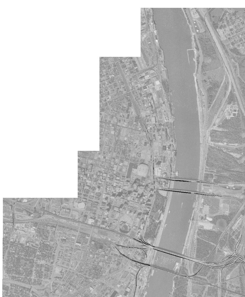
3 The purpose of the United States (U.S.) Numbered Highway System is to facilitate travel on the main interstate highways, over the shortest routes and the best available roads. A route should form continuity of available facilities through two or more states that accommodate the most important and heaviest motor traffic flow in the area. The routes comprising the National System of Interstate and Defense Highways will be marked with its own distinctive route marker shield and will have a numbering system that is separate and apart from the U.S. Numbered Highway System. For the convenience of the motorist, there must be continuity and a uniform pattern of marking and numbering these Interstate routes without regard to state lines. The U.S. Numbered System was established in 1926 and the Interstate Numbered System was established in Both have reached the period of review, revision, and consolidation. They now need perfecting rather than expansion. Therefore, any proposed alteration in the established systems should be extremely meritorious and thoroughly, though concisely, explained in order that the Special Committee on U.S. Route Numbering and the Standing Committee on Highways of the Association may give prompt and proper consideration to each and every request made by a member department. Explanation and Reasons for the Request: (Keep concise and pertinent): Interstate 70 will be relocated from the existing Poplar Street Bridge (which currently carries Interstates 70, 64 and 55, and U.S. 40) and re-marked onto a new Mississippi River Bridge that joins the states of Missouri and Illinois. The Interstate 70 relocation will add redundancy to the interstate system and will help alleviate the congested Poplar Street Bridge (PSB). The Interstate 70 relocation will also reduce the number of interstates on the existing river bridge (PSB) from three (3) to two (2). The existing PSB will now be marked just as Interstates 55 and 64 and U.S. 40. The new Mississippi River Bridge will be marked as Interstate 70. Date facility available to traffic Does the petition propose a new routing over a portion of an existing U.S. Route? No If so, where? n/a Does the petition propose a new routing over a portion of an existing Interstate Route? No Interstate 70 is on new alignment If so, where? n/a 2

4 Map of state, or portion thereof, indicating proposed addition or change in the U.S. Numbered or Interstate Numbered System: Send your PDF color map to or with this application. (Indicate termini and control points on the map for the route, and number them in sequence. Use the same numbers in column 1 tabulation, page 6, when listing mileage. Towns, cities, major highway intersections and state lines to be used as control points. The top of column 1, page 6, will be one terminus, and column 1 will give the log of the route as needed to describe the route in the Association publication U.S. Numbered Highways if the application is approved by the Standing Committee on Highways.) 3

5
6 The State agrees and pledges its good faith that it will not erect, remove, or change any U.S. or Interstate Route Markers on any road without the authorization, consent, or approval of the Standing Committee on Highways of the American Association of State Highway and Transportation Officials, not withstanding the fact that the changes proposed are entirely within this State. The weighted average daily traffic volume along the proposed route (relocated Interstate 70), as shown on the map on page 3, is 54,584 as compared to 25,000 for the year 2012 for the remaining portions of this U.S. Numbered Route in the State. The Purpose and Policy in the Establishment and Development of the United States Numbered Highways, as Retained from October 3, 1991 or the Purpose and Policy in the Establishment of a Marking System of the Routes Comprising the National System of Interstate and Defense Highways as Retained from August 10, 1973 has been read and is accepted. In our opinion, this petition complies with the above applicable policy. (Signature) Chief Executive Officer (Member Department) This petition is authorized by official action of under date of as follows: (Copy excerpt from minutes.) A letter from your Chief Executive Officer with the CEO s signature is sufficient when submitting your application, if you choose not to include the signature on this form. 4
7 Instructions for Preparation of Page 6 Column 1: Control Points and Mileage. Top of column is one terminus of road. Indicate control points by identical number as shown on map on page 3. Show mileage between control points in miles and tenths. Column 2: Pavement Type. Code High type, heavy duty H Intermediate type I Low type, dustless L (show in red) Not paved N (show in red) Column 3: Pavement Condition Code Excellent E Good G Fair F (show in red) Poor P (show in red) NOTE: In columns 2 and 3, where pavements types and conditions change, the location of the change shall be indicated by a short horizontal line at the proper place opposite the mileage log and the proper code letter (shown above) shall be entered in the respective column between the locations so indicated. Column 4: Columns 5 & 6 Columns 7 & 8 Column 9: Column 10: Column 11 Traffic. Indicate average daily traffic volumes in this column. Points of changes in these data to be indicated by short horizontal lines opposite the appropriate mileage point on the mileage log. Any existing main line rail crossing that is not separated shall be indicated at the appropriate mileage point by RXR - black if signalized - red if not protected by signals. Pavement Width and Shoulder Width. These columns to be completed by comparing standards of highway involved with applicable AASHTO standards. Entries that fall to the right of the tolerance lines (dashed) should be shaded in red. If there are no deficiencies indicate by use of the word NONE. Major Structures. Show in these columns those structures that do not meet AASHTO standards. Show by horizontal line sufficiently long to indicate percentage of deficiency. Portion on right of tolerance line shall be shown in red. Indicate length of structure in feet immediately under the line. Any sub-standard highway underpass structure shall be shown opposite the appropriate mileage point by the designation LP with the vertical clearance in feet following and shown in red. If there are no deficiencies indicate by the use of the word NONE. Vertical Sight Distance. Items to be shown in this column as a horizontal line, the length of which will indicate the deficiency as determined in accordance with comparisons with comparable AASHTO standards. Portions of the line past the tolerance line shall be shown in red. Horizontal Curvature. Curves in excess of AASHTO applicable standards to be shown in this column by a short horizontal line with degree of curve shown immediately above the line. To be shown in red. Percent Grades. Show by horizontal lines opposite proper mileage point on mileage log. Show percent of grade above the line and length of grade in feet immediately below. To be shown in red. What follows is an Excel worksheet that you can open by right clicking your mouse and select Worksheet Object you can then Edit, Open or Convert but you must first unlock the form as show when inserting maps.. 5
8 Mileage Control Points and Mileage Pavement Type Pavement Condition Traffic ADT Comparison to Applicable AASHTO Design Standards Pavement Width Deficiency Shoulder Width Deficiency Major Structures Roadway Width Deficiency H - Loading Deficiency Vertical Sight Distance Deficiency Show When In Excess of Standard Horizontal Curvature Percent Grade 0 Point 1 Percent Percent Percent Percent Percent Degree Length See the MoDOT appication for information in MO 0.8 Point mi.* H E None None None None None None** None 3.7 Point 3 * The 2.9 miles represents the length of the relocation in IL only. MoDOT is submitting a separate application for the 0.8 mi. segment in MO. **The ramp from Relocated I-70 (EB) to existing I-55/70 has a design speed of 50 mph. The ramp from existing I-55/70 to Relocated I-70 (WB) has a design speed of 50 mph. The posted speed on existing I-55/70 and I-64 is 50 mph in this area. The design speed on proposed Relocated I-70 is 70 mph, but will be posted 55 mph with advisory speeds of 50 mph on the aforementioned ramps. Note: All interstate-to-interstate ramps and roadways in IL meet or exceed minimum AASHTO standards. 6
9 Contact Information: Name: Kyle Armstrong Telephone Number: (217) Address: The following description will be provided to the AASHTO Highways Special Committee on U. S. Route Number (USRN). Where does the route begin? Where is it going? What type of facility is it traveling over? Explain the direction (north, east, south, and west). Name the focal point city or cities. Total number of miles the route will cover. Where does it end? Begin your description here: Where does the route begin? Where is it going? What type of facility is it traveling over? At the Missouri-Illinois state line along the alignment of the new Interstate 70 Mississippi River Bridge Connecting to existing Interstate 55/70 west of the IL 203 interchange with existing I-55/70 in Madison, IL New Interstate 70 alignment Explain the direction (north, east, south, and west). Easterly direction Name the focal point city or cities. Total number of miles the route will cover. Where does it end? St. Clair County in IL 3.7 miles (MO and IL) ; 2.9 miles (IL only) West of the IL 203 interchange with existing I-55/70 in Madison, IL 7
 Project at St. Louis, Missouri and St. Clair County, Illinois is nearing completion.")
10 August 28, 2013 Ms. Catherine Batey, Division Administrator Federal Highway Administration 3250 Executive Park Drive Springfield, IL Dear Ms. Batey: As you are aware, the New Mississippi River Bridge (MRB) Project at St. Louis, Missouri and St. Clair County, Illinois is nearing completion. It is anticipated this project will be opened to traffic in late The intent of this project, from its inception, was to remove the Interstate 70 (I-70) markings from the existing Poplar Street Bridge (PSB) and re-align I-70 on a new alignment and a new bridge across the Mississippi River. This new alignment connects to existing I- 70 in Missouri north of downtown St. Louis. On the Illinois side, the new alignment connects to the existing I-55/64/70 (tri-level) interchange in East St. Louis. Please refer to Attachment 1. Please note the attachment numbers for all attachments to this letter are displayed at the bottom of the first page of each attachment. The original Final Environmental Impact Statement (FEIS) was based on an expanded, ultimate plan a regional transportation improvement. It was approved via a June 13, 2001 Record of Decision. However, the alignment depicted in Attachment 1 represents only the initial (operationally independent) phase of the MRB Project. This phase was the subject of a re-evaluation of the FEIS, which was approved on October 13, Attachment 2 shows the differences between the original ultimate plan and the current interim improvement. In both cases, the I-70 marking was to be moved from the PSB to the new bridge across the Mississippi River. In conformance with the applicable federal regulations, we are now formally requesting changes regarding the interstate highway marking in Illinois within the MRB Project limits. Interstate Designation Request Our first request is for applying the I-70 designation to the new initial phase alignment described above. As depicted on Attachment 1 and described previously, we hereby request the department be permitted to display I-70 shields on (and on the approaches to) the new highway alignment in Illinois. As directed by a representative of the FHWA Missouri division, a separate but similar request will be submitted by the Missouri Department of Transportation for the remaining segment of the
11 Ms. Catherine Batey Page Two August 28, 2013 alignment in Missouri. The proposed I-70 alignment in Illinois is depicted by the green line on Attachment 1. Attachment 3 is a listing of completed NEPA and AJR actions in reference to the MRB Project. Please note the first group of documents and dates (through the September 17, 2003 approval date) were for the ultimate plan as described above. The remaining documents and dates are for the current interim project. Attachment 4 tabulates the approved design revisions and exceptions for relocated I-70 (or I-70 connection) which is the new alignment that connects the tri-level interchange to the new river bridge. The disposition of these revisions/exceptions is also noted in the table. Finally, this table also includes any revisions/exceptions regarding the relocated IL 3 interchange on the I-70 connector. Attachment 5 is a memo to the project files summarizing coordination between Illinois Department of Transportation (IDOT) District 8, Federal Highway Administration (FHWA) Illinois Division, and IDOT headquarters (Springfield) regarding design exceptions at the tri-level interchange. Please note all participants in these discussions are copies at the bottom of the memo. Attachment 5A is the attachment referred to in the memo. It summarizes all design exceptions and supplemental information requested by FHWA and IDOT headquarters. The disposition of these design exceptions is included in Attachment 5A. Attachment 6 is a summary of the status of the various MRB Project contracts as of April The essentially completed projects are shaded in green and the projects still under construction are shaded in orange. The department hereby confirms all of the completed projects have been constructed in accordance with the approved geometric and construction standards. Moreover, we confirm the completed contracts (as well as those not yet completed) will meet interstate standards. It is anticipated that all work on the MRB Project necessary to open the new lanes to traffic will be essentially complete by the end of Furthermore, the department confirms that no I-70 signs/shields for relocated I-70 will be displayed until all the necessary MRB Project segments are complete and verified and FHWA has provided final Interstate Designation approval. The IDOT plans for this project include measures such that no shields on the new alignment will be visible from active existing interstate traffic lanes or the shields will be covered. Interstate Change in Route Marking Request Our second request involves changes to the markings on the existing interstate roadways in the MRB Project area. Please refer to Attachment 1 for the limits of the route marking change. It is proposed to remove the I-70 route marking from the existing I-55/64/70 roadway segment between the tri-level and the PSB. This is depicted by the yellow lines on Attachment 1. This attachment
12 Ms. Catherine Batey Page Three August 28, 2013 was also included as an exhibit for our application to the American Association of State Highway and Transportation Officials (AASHTO). The department s AASHTO application is complete and will be submitted in time to be included on the agenda for the annual AASHTO meeting in October. A copy of the application is attached as Attachment 7. We are confident the information provided above and the attachments will be adequate for FHWA to proceed with processing and approving our Interstate Designation and Interstate Change in Route Marking requests. Your assistance in this endeavor is appreciated. If you have any questions or need additional information, please contact Ann L. Schneider, Secretary, located at 2300 South Dirksen Parkway, Springfield, Illinois 62764, by telephone (217) Sincerely, Enclosures Ann L. Schneider Secretary