Drones in Forestry: Regulations, Applications, and Considerations SESAF Conference Darian Yawn Paul Shepard
|
|
|
- Brianne Anderson
- 5 years ago
- Views:
Transcription
1 Drones in Forestry: Regulations, Applications, and Considerations 2018 SESAF Conference Darian Yawn Paul Shepard
2 About LMSS Forest Technology Solutions Provider Sales, Training, and Support Project Consulting, Rentals, Repairs Forest Technology Simplified!
3 Goals for Today Drone Background Current Drone Regulations Types of Drones Applications in Forestry
4 What is a Drone? Small unmanned aircraft system aka UAV, UAS, suas. Weight is greater than 0.5 lbs. and less than 55 lbs. including payloads. Usually carries an onboard camera or sensors or other payloads. Regulated by the FAA.
5 Drone Regulation Pre Drone development exploded as we waited for the FAA to create regulations for commercial use Strict FAA regulations with Section 333. Licensed pilot onsite 6 month wait time for Section 333 exemption. August 29, 2016 Part 107 Provisions New less rigid regulations from FAA Requires only remote pilot certification.


6 Drone Regulations Illegally Model or Hobby Commercially Governmental Use
7 Drone Regulation Government entities can fly under Part 107 rules or obtain a public COA (Certificate of Authorization). Law enforcement Public universities State governments Local municipalities
8 Hobby Use FAA interpretation of recreational/hobby use: Hobby is a "pursuit outside one's regular occupation and engaged in especially for relaxation." Recreation is "refreshment of strength and spirits after work; a means of refreshment or division.
9 Commercial Use Commercial uses can include: Selling photos taken from a UAS. Providing services such as inspections. Providing security services. Monitoring progress of work being performed.
10 Hobby vs. Commercial It's all about your intent. If anyone benefits from the flights, then the FAA considers the operation commercial. Note - No $ has to change hands.
11 Overview of Part 107 Rules Eligibility Requirements Minimum 16 years old Read, write, speak English Pass aeronautical knowledge test Pass TSA background check Obtain Remote Pilot Certificate Pass recurrent test every 24 months Conduct preflight inspections
12 Aeronautical Knowledge Test 60 Question Test (Multiple Guess A, B, or C) $150 Fee Estimated hours prep time. Must score 70 or better.

13 Aeronautical Knowledge Test Topics

14 Aeronautical Knowledge Test Cont.

15 Sectional Chart Aeronautical Knowledge Test Cont.
16 Aeronautical Knowledge Test Cont. 700 testing centers in US. After passing the exam, must go to the FAA IACRA site and complete the registration process. Temporary Certificate Issued/Followed by hard copy several weeks later. Certificate to be kept onsite during operations.
17 Overview of Part 107 Rules Avoid Hazardous Operation Don t fly over people or stadiums Don t interfere with manned aircraft No flying near emergency responders No drinking within 8 hours of flights
18 Overview of Part 107 Rules Other requirements Fly below 400 feet AGL Fly below 100 mph (87 knots) Fly during daylight hours No flights of multiple UAV s Cannot carry hazardous materials Yield ROW to all other aircraft Fly in controlled airspace ONLY with prior ATC approval. Maintain Visual Line of Sight VLOS
19 Waivers Waivers can be requested from the FAA to fly outside the requirements of the Part 107 rule. Operation from a moving vehicle Visual Line of sight Operation of multiple UAVs Operation over people Operation in certain airspace Operating limitations: altitude Operating limitations: minimum visibility
20 Application for Waivers 1. Apply for a COW (certificate of waiver) on FAA website. Include justification and supporting data. 2. Propose a safe alternative for the operation. 3. Must be approved by FAA granted they find that the operation can be safely conducted under the terms of that COW. 4. FAA strives to complete review of waiver application within 90 days. 5. They may also include specific special provisions.
21 Georgia Drone Laws Bylaws and rules set in place for the purpose of restricting certain areas of drone use to ensure that the public, and the users alike, are safe during any operation.
22 Georgia Drone Laws Do Not: 1. Video or photograph someone s personal property without permission. 2. Interfere with an emergency scene or personnel. 3. Fly in or around certain locations such as the capitol or on restricted public lands. 4. Arm or use a drone as a weapon. 5. Take off from or to recover a drone from private or public property without permission. 6. Use drones for hunting and fishing or interfere with someone else that is hunting, fishing, or trapping.
23 Georgia Drone Laws HB481 passed and effective July 1, 2017: Prohibits local communities from enacting their own drone laws except: 1. Ordinances adopted on or before April 1, Ordinance that enforce FAA restrictions. 3. Ordinances that prohibit launch or landing of UAS on/from public property except for commercial purposes.
24 Drone Regulation Considerations How will you fly? Part 107? Section 333? COA? Do you need a waiver? Online prep course for Airman s Knowledge test. o Drone Pilot Ground School o UAV Coach Use a licensed/certified pilot for contract work. Know and stay abreast of FAA, state, and local regulations.
25 Drone Hardware


26 UAV/Drone Hardware Fixed Wing Simpler structure Faster Longer flights More expensive Mostly autonomous Aerial mapping Takeoff/Landing more difficult

27 UAV/Drone Hardware Rotary Wing Relatively inexpensive Easy to operate Compatible with ios & Android tablets Widely used, well supported Flexible payloads/sensors

28 UAV/Drone Hardware Hybrid FireFly6 Vertical takeoff and landing Fixed Wing Longer flights Ideal for Mapping Manual and Autonomous Cost Effective Small Takeoff/Landing Area


29 Drones in Forestry Inspections Camera for Pics and Video Controller Smart Device Apps


30 Useful Drone Apps B4UFLY FAA app designed to help UAV users determine whether there are any restrictions in effect at the location where they want to fly. Inspections UAV Forecast UAV Mapping

31 Drone Applications Inspections Live camera view while in flight Capture video/pictures


32 UAV/Drone Inspections Bug Spots Disease and fire hazards


33 UAV/Drone Inspections BMP Compliance Harvest Inspection


34 UAV/Drone Inspections Stand Density Regeneration


35 UAV/Drone Inspections SMZ Inspection Beaver Damage


36 UAV/Drone Inspections Controlled Burn/Wildfire Monitoring


37 UAV/Drone Inspections Wildfire Hot Spot Locations


38 UAV/Drone Inspections Site Prep Evaluation Planting

39 Storm Damage UAV/Drone Inspections
40 UAV/Drone Mapping Mapping Workflow Designate area of interest/layout grid on app Upload Mission to UAV Autonomously fly mission Download data from UAV Process data in desktop software/cloud service Create 2D Mosaic/3D Model
")
41 UAV/Drone Mapping Mission Planning ios or Android Simple controls Set Altitude Easily create Area of Interest (AOI) Upload to UAV
42 UAV/Drone Mapping Fly the Mission Launch UAV (ops check) Fully autonomous Monitor status on PC or tablet UAV returns to home location Regain control at any time Fail-safes in software
43 Drone Imagery Processing Options PC Based Software: Pix4D Agisoft Drone2Map Must have a PC with excellent processing power Higher upfront cost Purchase outright or lease Processing can take considerable time 4-8 hours Managing data over time considerations
44 Drone Imagery Processing Options Cloud Based Software: Maps Made Easy Drone Deploy Pix4D Cloud Less powerful PC required Can be much less expensive per flight Processing typically takes hours Data management still a concern Easier comparison of previous flights
45 UAV/Drone Mapping Outputs 2D Mosaic Imagery Survival checks High resolution imagery Site prep acres 3D Models DSM Digital Surface Model DTM Digital Terrain Model Stockpile/Log Deck Volumes

46 UAV/Drone Mapping High Resolution Orthomosaics Stitches all project photos into one mosaic

47 UAV/Drone Mapping 3D Models

48 UAV/Drone Mapping Stockpile Volumes Define the pile base and calculate the stockpile volume

49 UAV/Drone Mapping Log Deck Volumes

50 UAV/Drone Mapping Stand Delineation

51 UAV/Drone Mapping Stocking Count Sampling grid with 50 th acre buffers applied Survival counts in the office

52 UAV/Drone Mapping Stand Survival Assessment Survival Mapping


")

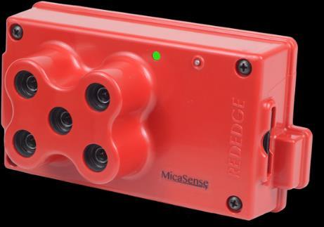


53 UAV/Drone Payloads RGB Camera (True Color) Multispectral (Includes NIR) Hyperspectral (Includes NIR) Thermal Infrared LIDAR
54 UAV/Drone Payloads Map forest health over time Assess drainage issues Detect Nitrogen deficiencies Map drainages not detected by traditional imagery Assist wildlife inventories and habitat mapping Detailed canopy height models


55 UAV/Drone Future Coming Down the Road? Forest Inventories with Drones?

56 Questions??