Draft. CHAPTER TWO Recommendations
|
|
|
- Emerald Edwards
- 5 years ago
- Views:
Transcription
1 CHAPTER TWO Recommendations July 2004
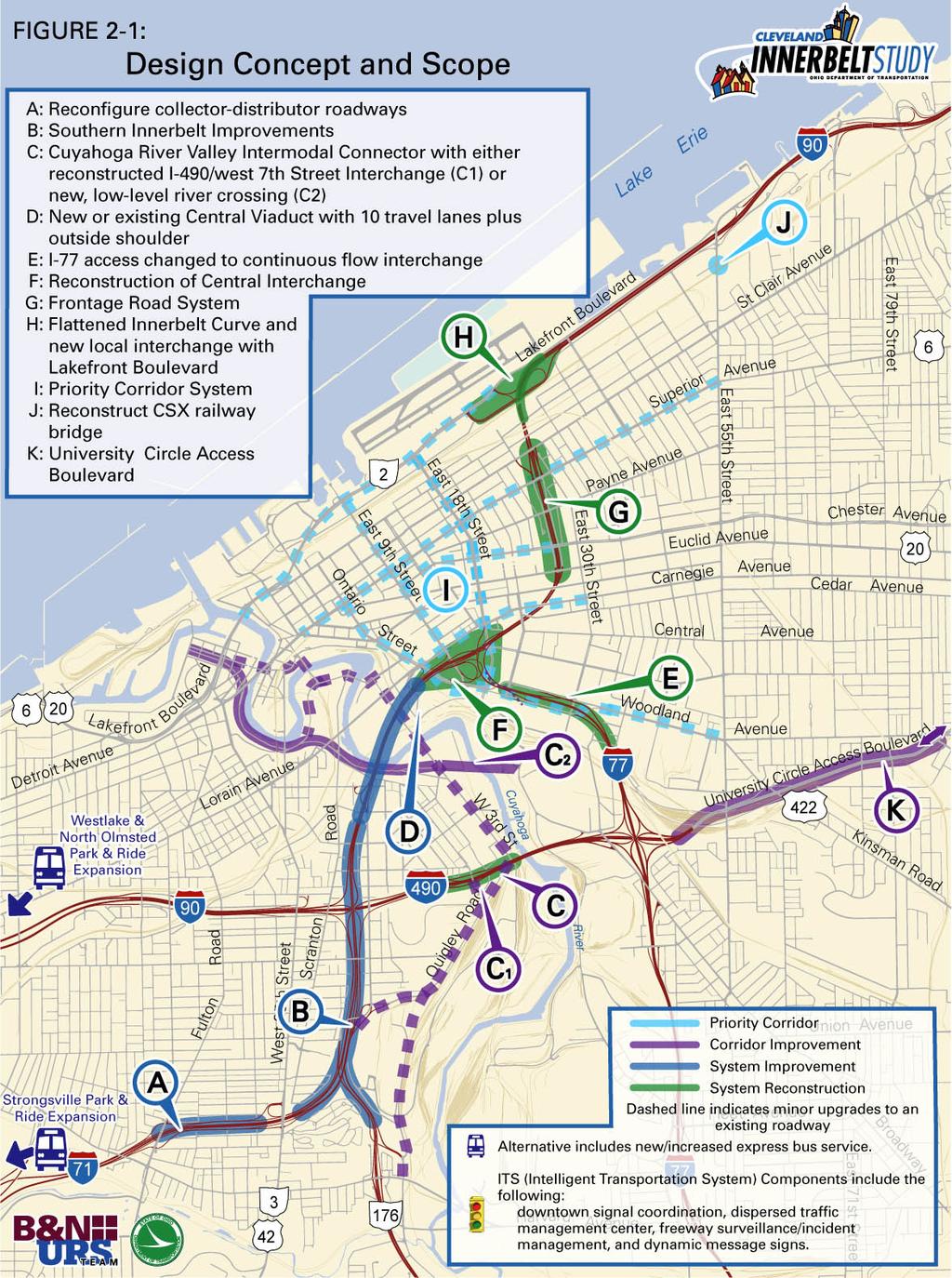
2 2.1. DESIGN CONCEPT & SCOPE CHAPTER TWO RECOMMENDATIONS This study sought to address the problems outlined in the Purpose and Need Statement through development of this Strategic Plan for the intelligent renewal of the transportation infrastructure in the corridor. The alternative outlined in this document has been developed to address the problems outlined in the Purpose and Need. It is anticipated that in 2006 ODOT will initiate construction of a sequence of projects that will comprise this overall strategy. In the Hybrid Alternatives Analysis phase of the process, the Design Concept and Scope (Figure 2-1) was developed through the refinement of alternatives, with the assistance of the Cleveland community. ODOT held an ongoing series of meetings with the public to gather input and ideas to refine the alternatives. The Design Concept and Scope presented in this document is a refinement of the Hybrid Alternatives and Conceptual Alternatives. Description The following summary highlights the required elements of the work within each major freeway segment. Pavement and Bridge Deck Replacement/Rehabilitation includes: I-71 mainline pavement replacement/rehabilitation from the Fulton Road interchange north to the south end of the Central Viaduct I-90 mainline pavement replacement/rehabilitation from the north end of the Central Viaduct to just east of the Innerbelt Curve, located at the Cleveland Memorial Shoreway interchange I-77 mainline pavement replacement/rehabilitation from the Kingsbury Run Bridge to the Central Interchange Ramp and connecting roadway pavements replacement/rehabilitation. All of the remaining original bridge decks along the Innerbelt mainline and the interchange bridges within the corridor need to have their decks replaced within the renewal time frame. In addition to the elements of work required to renew the physical condition of the Innerbelt Freeway, the following discusses the various components necessary to address the Cleveland Innerbelt Study s Purpose and Need. For more detail on these components, please refer to the corresponding Decision Memorandum. Concerns with the Design Concept and Scope raised by the City of Cleveland for consideration during Steps 5-8 of the PDP are summarized in Appendix B. Letters from various stakeholders are included as an addendum to the Design Concept and Scope document, to further serve as documentation of the concerns raised during the study. Page 2-2 July 2004
3
4 Design Concept and Scope Components are as follows: Collector-Distributor Roadway o Relocate the C-D Roadway between Fulton Road and West 25th Street at the same grade as and adjacent to mainline I-71 Southern Innerbelt Improvements o Add one northbound mainline lane to I-71 between SR-176 and I-90 o Add one lane in each direction on I-90 between I-71 and the Central Viaduct Bridge Cuyahoga River Valley Intermodal Connector o Complete the I-490/West 7th Street interchange upgrade to full interchange or add new lift bridge to access existing Broadway partial interchange. o Quigley Road Connector o Rehabilitate West 3rd Street and Quigley Road o West Bank Connector o Jennings Road to Quigley Road Connector. Central Viaduct Bridge o Add one lane in each direction to I-90 o Minimum inside shoulder o Full outside shoulder o Existing or New Bridge o Existing or Parallel Alignment Central Interchange Reconstruction/I-77 Access o Central Interchange Separation of System and Service Movements Consolidation of Access Access provided to Ontario Street, East 9th Street and East 18th Street I-77NB to I-90WB and I-90EB to I-77SB movements redirected to I- 490/I-77 Interchange o I-77 Access Separation of System and Service Movements Consolidation of Access I-77 access in Central Interchange redirected to Orange and Woodland Boulevards Frontage Road System o Consolidation of Access o Freeway Ramp Connections at Chester Avenue and Superior Avenue o Frontage Road System between Chester Avenue and St. Clair Avenue Flattened Innerbelt Curve o Flatten I-90 mainline curve o Add one westbound to I-90 within interchange o Reconstruct I-90/SR-2 interchange o Convert System interchange to Service interchange o Construct E 40th Street overpass Priority Corridor System o Operational Improvements to: Page 2-4 July 2004
5 o East 9th Street o East 18th Street o Ontario/Woodland Corridor o Frontage Road Corridor o Carnegie Avenue o Chester Avenue o Superior Avenue o Lakefront Boulevard University Circle Access Boulevard Reconstruct CSX Railway Bridge on E 55th Street Westlake Park-and-Ride Expansion Strongsville Park-and-Ride Expansion North Olmsted Park-and-Ride Expansion Intelligent Transportation System (ITS) o Freeway Management System o Arterial Management System o MOA/MOT Management System PROJECT BREAKDOWN Innerbelt Project Innerbelt Logical Termini Primary Logical Termini The primary logical termini for the Innerbelt Project are the I-71/SR-176 interchange and the I-90/SR-2 interchange (). The primary logical termini define the limits of the Innerbelt Freeway. The selection of the logical termini was based on an evaluation of a number of different parameters: Function Operational Performance (Running Speed and Level of Service) Safety (Crash Analysis) Infrastructure. The I-71 interchange with SR-176 (Jennings Freeway) was selected as one of the primary logical termini because the convergence point of these two radial freeways establishes the southwestern-most limits of the Innerbelt Freeway. In addition, the convergence of these two radial freeways coincides with the following: Southwestern-most convergence point of the system of radial freeways Daily recurring congestion occurs at the point where the basic number of lanes on NB I-71 is reduced from three lanes to two Daily recurring congestion occurs south of the point where the lane of NB SR-176 must merge into the two lanes of NB I-71 Page 2-5 July 2004
6 The 1996 Freeway System Bottleneck Study conducted by the Northeast Ohio Areawide Coordinating Agency (NOACA) indicates that the Level of Service (LOS) drops to an LOS F during the AM peak period in the two-lane section of NB I-71 The crash analysis attributes the elevated crash rate (2.18/Million Vehicle Mile [MVM]) and percentage of rear-end accidents (41.3 percent) to the inability of drivers to safely adjust their travel speed in response to the daily recurring congestion that results from the reduction in the basic number of lanes from three to two The concentration of bridge decks begins at this system interchange. The I-90 (Memorial Shoreway-East) interchange with SR-2 (Memorial Shoreway-West) was selected as the northern logical terminus because the convergence point of these two radial freeways establishes the northeastern-most limits of the Innerbelt Freeway. In addition, the convergence of these two radial freeways coincides with the following: Northeastern-most convergence point of the system of radial freeways The concentration of downtown service interchanges begins immediately west of this system interchange Daily recurring congestion occurs at the points where the basic number of lanes on WB I-90 is reduced from four to two The 1996 NOACA Freeway System Bottleneck Study indicates that the level of service drops to a LOS F during the AM peak period in the two-lane section of westbound I-90 The crash analysis attributes the elevated percentage of failure to control crashes (32.5 percent) to the inadequate horizontal geometry in this location. There were a total of nine crashes in a 3-year period that involved vehicles overturning at this location. Intermediate Logical Termini A number of freeways radiate from the Cleveland Innerbelt Freeway. In addition to the primary logical termini of the Innerbelt Freeway described above, there is a need to describe the intermediate logical termini for each of the radial freeways. The intermediate logical termini define the Innerbelt Corridor or project area (). The selection of the intermediate logical termini for the radial freeways was based primarily on operational performance. The Fulton Road/West 25 th Street interchange was selected as the intermediate logical termini on I-71 because this pair of interchanges, which share a common collector-distributor roadway system, coincides with the following: This is the first interchange along this radial freeway south of where it enters the Innerbelt Freeway The number of through lanes is reduced from four lanes to three lanes immediately south of this pair of interchanges The 2002 NOACA travel time study indicates that during the AM peak period, running speeds drop from in excess of 60 mph south of West 25 th Street to less than 20 mph north of West 25 th Street Page 2-6 July 2004
7 Fulton Road, West 25 th Street, and Scranton Road are used as alternate routes to the Central Business District (CBD). The I-90 (Memorial Shoreway-East) interchange with SR-2 (Memorial Shoreway-West) remains as the northern logical termini as discussed in the previous section describing the Primary Logical Termini. The East 9 th Street interchange was selected as the western logical terminus on SR-2 because this interchange coincided with the following: This is the first interchange along this radial freeway west of where it enters the Innerbelt Freeway. The Denison Avenue Interchange was selected as the southern logical terminus on SR-176 because this interchange coincides with the following: This is the first interchange along this radial freeway south of where it enters the Innerbelt Freeway The NOACA travel time study indicates that during the AM peak period running speeds drop from 62 mph south of Denison Avenue to less than 20 mph north of Denison Avenue. The East 30 th Street/Woodland Avenue Interchange was selected as the southern logical terminus on I-77 because this interchange coincides with the following: The East 30 th Street/Woodland Avenue interchange is the first in a series of interchanges that provide direct access to the CBD from I-77 The NOACA travel time study indicates that during the AM peak period, northbound running speeds drop from in excess of 45 mph south of the East 30 th Street/Woodland interchange to 38 mph north of the interchange The concentration of bridge decks begins immediately north of this interchange. There are also two pairs of bridges located immediately south of this interchange; however, the Kingsbury Run Bridges (CUY L&R) were replaced in 2000 and the decks of the I-77 bridges over I-490 (CUY L&R) are scheduled to be replaced and widened in The West 7 th Street interchange was selected as the eastern logical terminus on I-490 because this interchange coincides with the following: This is the first interchange along this radial freeway east of where it enters the Innerbelt Freeway. The I-90/West 25 th Street interchange was selected as the western logical terminus on I-90 because this interchange coincides with the following: This is the first interchange along this radial freeway west of where it enters the Innerbelt Freeway Page 2-7 July 2004
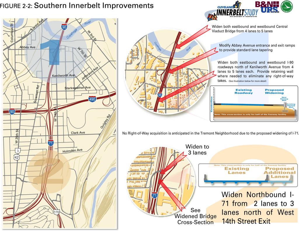
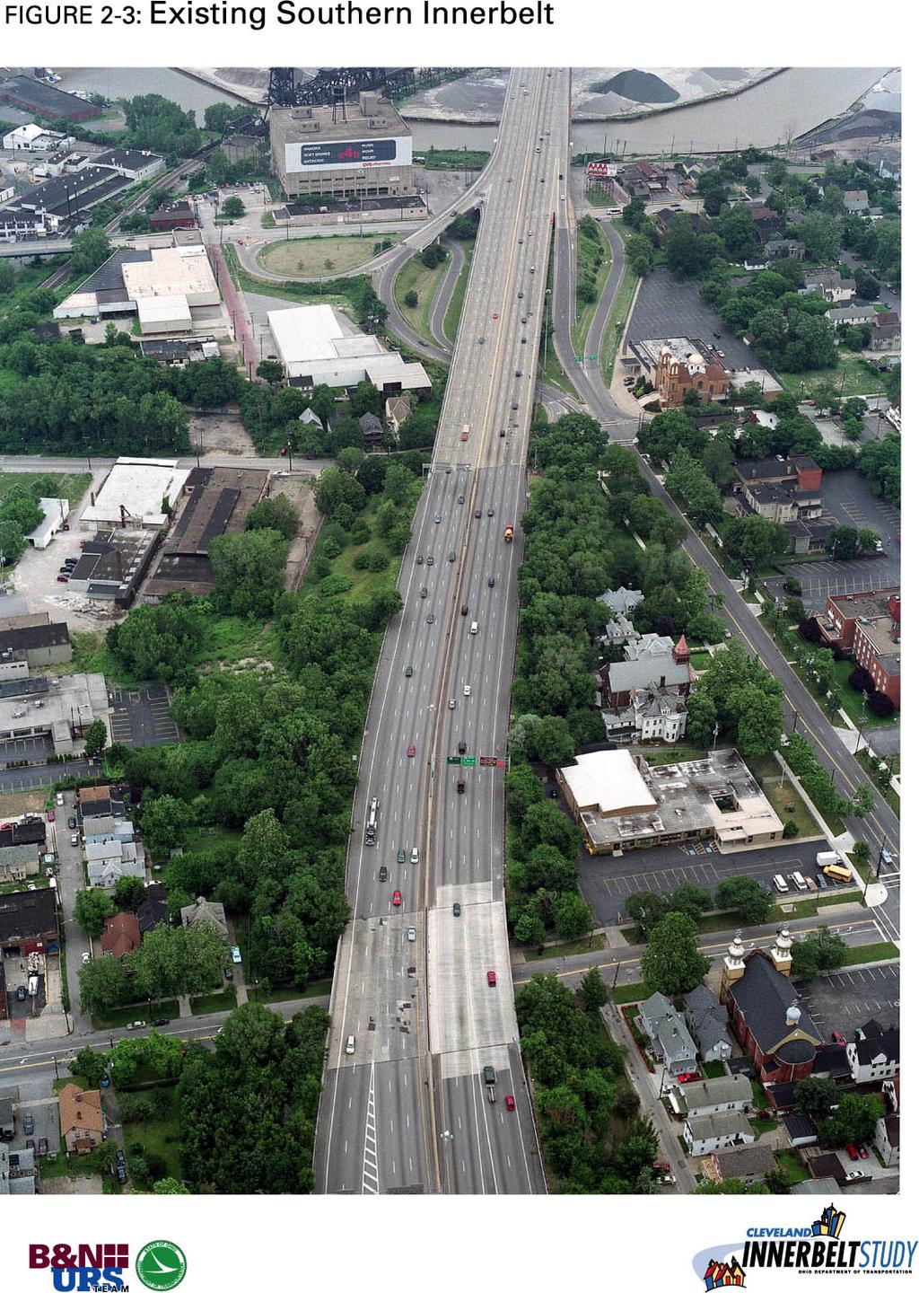
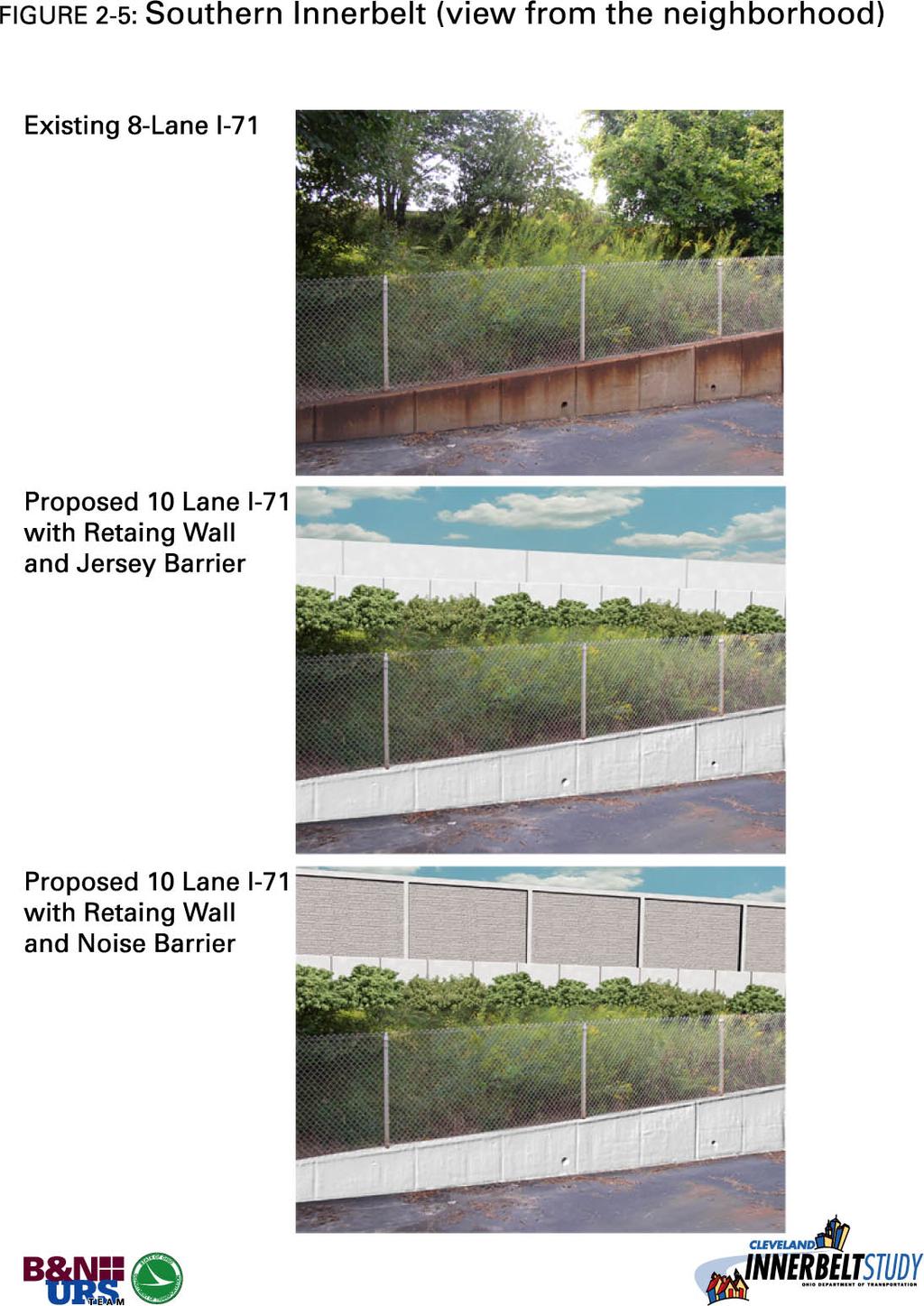
8 The NOACA travel time study indicates that during the AM peak period running speeds drop from 60 mph west of West 25 th Street to 26 mph west of the I-90/I-71/I- 490 interchange. The Central Interchange (Figure 1-1), as defined for this study, is a triangular area bounded by Carnegie Avenue on the north, East 22 nd Street on the east and Broadway Avenue on the southwest, and includes the system interchange between I-77 and I-90, as well as the connections between these two Interstate highways and the local street system Innerbelt Project Description In addition to the required pavement and bridge deck elements of work needed along the Innerbelt Freeway, the following discusses the various components necessary to meet the Cleveland Innerbelt Study s Purpose and Need. The format of the following discussion includes a description of the listed component, followed by the recommendation summary from the corresponding Decision Memorandum. Reconfigure Collector-Distributor (C-D) Roadways The existing C-D roadway system between Fulton Road and West 25 th Street is proposed for reconstruction. In the current configuration, the existing C-D roadways climb the embankment between interchanges and run along the top of the embankment, directly adjacent to the neighborhood. A C-D roadway system is typically constructed at the same grade and directly adjacent to the mainline freeway. Thus, when reconstructed, these C-D roadways would be relocated and the top of the existing slope would be returned to a natural vegetative state. C-D Roadways Summary Collector-Distributor (C-D) Roadways (September 11, 2003) As this segment of the roadway pavement is reconstructed, it would be advantageous to relocate the C-D roadways to a location directly adjacent to and at the same grade as the mainline. The vacated land resulting from the relocation of the C-D roadways would be returned to a natural, vegetative state. The cost to relocate the C-D roadways at the same time as I-71 is reconstructed would be less than the cost of relocating the C-D roadways project independently. From an operational and safety standpoint, there are no differences between C-D roadways at the top or bottom of the slope. Thus, it is recommended that at the time the mainline I-71 pavement between Fulton Road and West 25 th Street is to be reconstructed, the C-D roadways should be relocated and reconstructed. Southern Innerbelt Improvements Two of the four primary bottlenecks within the study area are located in the section of the Innerbelt Freeway from the MetroHealth Curve to the southwestern end of the Central Viaduct Bridge. These bottlenecks are addressed in this component of the Design Concept and Scope. The solution proposed for the problems associated with these two bottlenecks has been commonly referred to as the Southern Innerbelt Improvements (Figure 2-2). Currently, a Page 2-8 July 2004
9 bottleneck is associated with the MetroHealth Curve along I-71. This bottleneck is caused by the reduction of mainline I-71 from three lanes to two lanes in the segment preceding the SR- 176 (Jennings Freeway) merge. This mainline reduction is currently in place to improve the merge with traffic from I-90 eastbound. The merge is accomplished by allowing two lanes from I-71 northbound and two lanes from I-90 eastbound to join, forming the existing fourlane, eastbound cross section of the Central Viaduct Bridge. Further, the entrance from the Jennings Freeway to I-71 northbound is also a bottleneck. The heavily traveled Jennings Freeway terminates at a merge with the two northbound lanes of I-71. The volume of traffic utilizing this merge results in severe congestion in the peak period. To eliminate these two bottlenecks, I-71 northbound will be widened to three lanes in the area of the Jennings Freeway merge. This widening of I-71 will be accomplished within the existing highway right-of-way (Figure 2-2). The widening of I-71 northbound will require the widening of I-90 eastbound across the Central Viaduct Bridge from four to five lanes. This will allow the three lanes of I-71 northbound plus the two lanes of I-90 eastbound to form the five travel lanes on the Central Viaduct Bridge. Currently, westbound I-90 across the Central Viaduct Bridge functions with four westbound lanes. At the start of I-71 southbound, westbound I-90 diverges with a drop-lane and decision-lane configuration. The outermost lane is an exit only lane and the adjacent lane is a combined exit and through lane, where the driver must make a decision to either exit or continue through on the current path of travel. This configuration provides two exit lanes for I-90 three through lanes for I-71. Improvements to the Central Interchange area includes an additional I-90 westbound lane, making a total of five travel lanes crossing the Central Viaduct Bridge, approaching the I-71/I-90 diverge. To accommodate this widening of the Central Viaduct Bridge, as southbound I-71 exits from westbound I-90, the two outermost lanes would connect to westbound I-90 and the three innermost lanes would connect to southbound I-71 (Figures 2-3, 2-4, and 2-5). Due to the widening of I-90 from four travel lanes to five travel lanes in each direction, the West 14 th Street entrance and Abbey Avenue exit ramps will be realigned. Southern Innerbelt Improvements Summary Southern Innerbelt Improvements (September 11, 2003) The safety and operational impacts of the existing lane imbalance in the Southern Innerbelt area are severe. This lane imbalance causes increased congestion in the AM peak period, which results in increased crashes on this segment of roadway. Further, the convenient congestion by-pass offered by the configuration of the West 14 th Street interchange encourages commuters to cut-through the neighborhood to avoid being caught in the resultant queues. The operational modeling of this component shows that the proposed reconfiguration of the Southern Innerbelt area has a positive impact on mainline operation and reduces cut-through traffic along West 14 th Street. The improvements associated with the University Circle Access Boulevard and the complete reconstruction of the Central Interchange are shown to have a synergistic impact on further Page 2-9 July 2004
10
11
12
13
14 reducing this cut-through traffic. Thus, the Southern Innerbelt component is part of the Design Concept and Scope. Central Viaduct Bridge To accommodate the changes proposed for both the Southern Innerbelt area and the Central Interchange, the Central Viaduct Bridge will need to be widened to five travel lanes in each direction. Central Viaduct Bridge Summary Central Viaduct Bridge (November 13, 2003) The interrelationship between the Central Viaduct Bridge and the Central Interchange and Southern Innerbelt areas was a key factor in determining the operational impacts of an alternative for the Central Viaduct Bridge. The high volume of traffic across the Central Viaduct Bridge coupled with the recommended Central Interchange and Southern Innerbelt area configurations requires that the Central Viaduct Bridge maintain five travel lanes in each direction to adequately address the operational issues in these three segments of the Innerbelt Freeway. Thus, widening the Central Viaduct Bridge to five travel lanes in each direction is part of the Design Concept and Scope. The provision of an outside shoulder provides a breakdown refuge area for stranded motorists, allowing motorists who experience mechanical difficulty to move out of the traveled way. This preserves the full operational capacity of the Central Viaduct Bridge, which is especially important during peak hour operation. This breakdown shoulder further provides an area where emergency services can move incident involved vehicles. Thus, for safety and operational reasons, outside breakdown shoulders on the Central Viaduct Bridge are part of the Design Concept and Scope. For consistency reasons, full inside shoulders are not recommended across the Central Viaduct Bridge, as they are not provided elsewhere within the corridor. To summarize, it is recommended that the Central Viaduct Bridge provide five travel lanes in each direction and outside breakdown shoulders. Central Interchange and I-77 Access The Central Interchange area represents one of the four primary bottlenecks that have been identified in the study area. The existing Central Interchange (I-90/I-77 interchange) must handle four traffic movements in a constrained geographic area. First, the Central Interchange handles the movement of traffic between I-90 and I-77. Second, it handles traffic interchanging between I-90 and the local street system. Third, it handles traffic interchanging between I-77 and the local street system. Fourth, it handles the movement of traffic on the local street system that is on one side of the Innerbelt and is traveling to the other side of the Innerbelt facility. The goal of the interchange modification is to improve the overall operation of the Central Interchange by relocating the interchange of I-77 traffic to/from the local streets. This relocation will improve capacity for all the traffic movements and, as a result, improve Page 2-14 July 2004
15 safety. Thus, all local movements to/from I-77 are relocated to the reconfigured Broadway/Orange Boulevard interchange area. Once the interchange between I-77 and the local street grid is relocated, the remaining movements are completely reconstructed. Interface points between the freeway and local street grid are consolidated and reoriented to allow all ramps to be designed to current design standards. Further, these reconfigured access points will be easier to sign for wayfinding. Due to the importance and of the Central Viaduct Bridge and the interdependency between the Central Viaduct Bridge, the Central Interchange, and the I-77 interchange with East 30 th Street, the Central Viaduct Bridge configuration will dictate the configuration of the Central Interchange and I-77 interchange with East 30 th Street. The Central Viaduct Bridge, as part of the Design Concept and Scope, could be a structure on the existing alignment or on a new alignment. If the structure remains on the existing alignment, the reconstructed Central Interchange (Figure 2-6) includes the following changes: Upgrade the loop ramp design speed to 45 mph Realign Community College Avenue and East 18 th Street to form a new intersection Realign Ontario Street around the new I-90 exit loop ramp to Ontario Street Remove the I-77 southbound entrances from Ontario Street, East 9 th Street, East 14 th Street, and East 21 st Street Remove the I-77 northbound exits to Community College Avenue, East 18 th Street and East 22 nd Street Remove the I-90 eastbound exit to Broadway Avenue and the exit to East 22 nd Street Remove the I-90 westbound entrance from East 14 th Street Connect Broadway to West 3 rd Street for access to the Flats and Industrial Valley. If the Central Viaduct Bridge is reconstructed on a new alignment, then the Central Interchange (Figure 2-6) further includes the following changes: Realign Ontario Street and East 9 th Street to better interface with the one-way configuration of Woodland Avenue and Orange Avenue Realign Community College Avenue and East 18 th Street to form a new corridor Provide access to I-90 at Ontario Street, East 9 th Street and East 18 th Street Remove the SB I-77 entrances from Ontario Street, East 9 th Street, East 14 th Street, and East 21 st Street Remove the NB I-77 exits to Community College Avenue, East 18 th Street and East 22 nd Street Remove the EB I-90 exit to Broadway Avenue and the exit to East 22 nd Street Remove the WB I-90 entrance from East 14 th Street Provide access to the Intermodal Connector via Broadway to access the Flats and Industrial Valley. A key to improving traffic flow, capacity, and safety to and through the Central Interchange is to separate the I-77 access to the local street grid from the Central Interchange. This is accomplished by improving the current I-77 interchange with East 30 th Street and removing I-77 access from the Central Interchange area. Page 2-15 July 2004

16
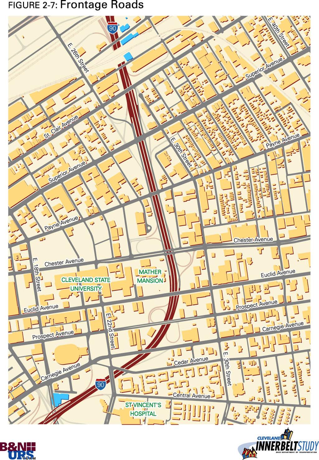
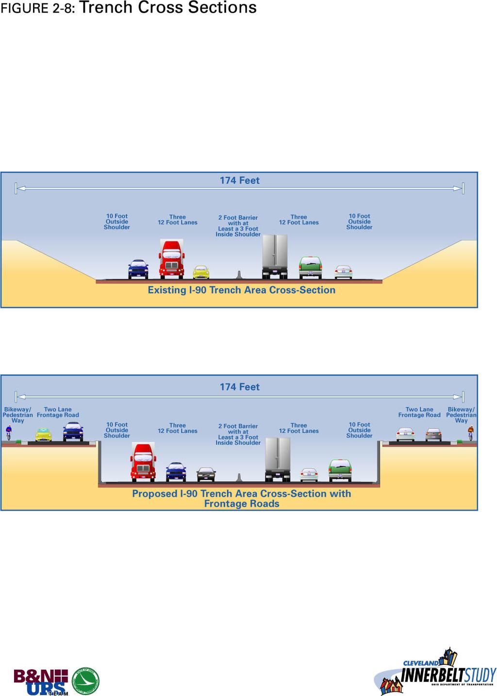
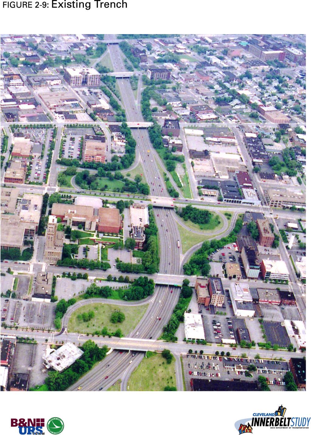
17 The improved interchange, regardless if the Central Viaduct Bridge alignment changes, includes the following alterations: East 30 th Street remains continuous beneath the interchange between the eastbound and westbound roadways of the Ontario/Woodland Boulevard Ontario/Woodland Boulevard eastbound to I-77 southbound and Ontario/Woodland Boulevard westbound to I-77 northbound are continuous movements I-77 northbound exit with the Ontario/Woodland Boulevard, East 30 th Street with westbound Ontario/Woodland Boulevard East 30 th Street with eastbound Ontario/Woodland Boulevard are all signalized intersections East 22 nd Street thru connections remain. Central Interchange and I-77 Access Summary Central Interchange and I-77/East 30 th Street Interchange (October 9, 2003) The operational modeling of this component shows that the proposed reconfiguration of the existing Central Interchange and I-77/East 30 th Street interchange, which incorporates a relocation of I-77 access and a complete reconstruction of the ramps accessing Ontario Street, East 9 th Street and East 18 th Street, has the greatest positive impact to the freeway system and to the city street grid. This improved operation coupled with the elimination of the design deficiencies associated with the existing Central Interchange will improve safety in the corridor. Thus, to improve the geometry, operation, and safety of the Central Interchange and I-77/East 30 th Street interchange, this component is included as part of the Design Concept and Scope. The appropriate alignment of this configuration will be advanced once a decision regarding the Central Viaduct Bridge alignment is made. Innerbelt Trench The orientation of the interchanges along I-90, between the Central Interchange area and the Innerbelt Curve is such that drivers wanting to access the CBD often must take an indirect path once exiting the freeway to eventually travel towards the CBD. The number of interchanges and the confusion created from their orientation reduces their operational efficiency and makes them less appealing as choices for drivers, especially those not familiar with the area. This leaves the ramps of the Central Interchange area, particularly East 9 th Street and Ontario Street, as the only clear access points to the CBD from I-90. This alternative addresses this traffic flow issue by creating a frontage road system (Figures 2-7 to 2-10) from Chester Avenue north to St. Clair Avenue. This frontage road system consolidates direct access to the freeway, while maintaining access to all cross-streets within the area of the frontage road system. Direct access, entrance and exit, from the freeway to the frontage road system will be provided at Chester Avenue and Superior Avenue. The oneway frontage road pair that would parallel the freeway provides indirect access to all other cross-streets. The northbound frontage road is constructed on the east side of the Innerbelt Freeway and the southbound frontage road is constructed on the west side of the Innerbelt Freeway. The frontage road system resides at the same grade as the city street grid and intersects the existing street grid at all major cross-streets. This frontage road system also opens access to parcels fronting the Innerbelt in the trench area that were previously landlocked along with parcels vacated from the removal of the existing interchanges. Page 2-17 July 2004
18
19
20
21
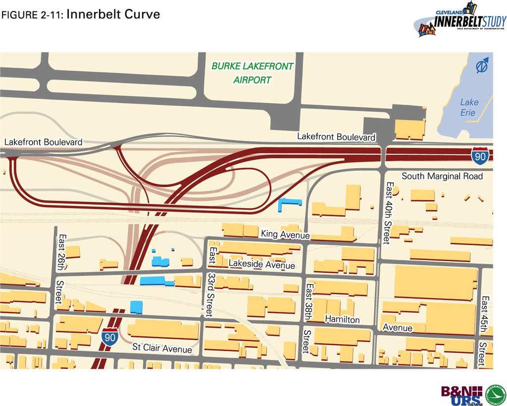
22 The frontage road concept removes the existing interchanges at both Prospect Avenue and Carnegie Avenue. Access to these corridors would be provided through the reconfigured Central Interchange area via East 18 th Street. Traffic may then move to and from the Prospect/Carnegie corridors via East 18 th Street or the East 21 st /22 nd Street pair. The frontage road system also opens the potential for freeway caps between East 22 nd Street and Euclid Avenue, between Chester Avenue and Payne Avenue, and between Payne Avenue and Superior Avenue. Innerbelt Trench Summary Innerbelt Trench (October 9, 2003) The design deficiencies, acceleration, deceleration, weave and terminal spacing lengths are inadequate and adversely affect the operational performance and safety of the Innerbelt Freeway. The ability to eliminate these design deficiencies, and thus the ability to improve the operational performance and safety of the Innerbelt Freeway, is a function of the service interchange spacing. Expressed another way, the current average service interchange spacing of one-quarter mile severely limits the potential to improve operational performance and safety. The operational modeling of this component shows that the proposed reconfiguration of the Frontage Roads has a positive impact on operation. Further, with the elimination of the design deficiencies associated with the Innerbelt Trench, safety in the corridor will be improved. Thus, the Frontage Road component, to improve the geometry, operation and safety of the Innerbelt Trench, is part of the Design Concept and Scope. Innerbelt Curve One of the four primary bottlenecks associated with the study area occurs in the Innerbelt Curve. The extreme geometry of the existing Innerbelt Curve causes both operational problems as motorists slow down in approach to the curve and safety problems. Further, under the current configuration, only two of the four westbound I-90 lanes continue through the curve, with the remaining lanes dropping to SR-2. To address this bottleneck, the Innerbelt Curve is flattened (Figure 2-11). Essentially, the curve radius is increased. As part of this proposed change, three through westbound lanes would continue through the curve and into the trench area. Also, to improve operations, the existing entrance ramp from St. Clair Avenue to eastbound I-90, the existing exit ramp from eastbound I-90 to Lakeside Avenue, and the existing entrance ramp from Lakeside Avenue to westbound I-90 would be removed. Truck access to and from the Lakeside Industrial Area would be facilitated through the existing Superior Avenue and East 55 th Street interchange and through a potential connection to the Lakefront Boulevard at East 40 th Street. Innerbelt Curve Summary Innerbelt Curve (September 11, 2003) The safety and operational impacts of the existing design of the Innerbelt Curve and the associated interchange of I-90 and SR-2 are severe. Further, the poor geometry and spacing associated with the Lakeside and St. Clair ramps further exacerbate these problems. The operational modeling of this component shows that Page 2-22 July 2004
23
24 the proposed reconfiguration of the Innerbelt Curve has a positive impact on operation. Further, with the elimination of the design deficiencies associated with this curve, safety in the corridor will be improved. Thus, to improve geometry, operation, and safety, the Innerbelt Curve is included as part of the Design Concept and Scope. Priority Corridor System The City of Cleveland s CBD has no clear street system hierarchy in place. Typically, traffic should be collected on minor roadways, moved to larger roadways, and carried to the freeway. From smallest to largest, these roadways are: collector/distributor, minor arterial, major arterial, boulevard and freeway. The street grid should function much like a river and its tributaries. The roadways identified as Priority Corridors (Figure 2-12) operate as described in the following: Ontario/Woodland corridor Ontario Street and Woodland Avenue act as one-way couplers east of the Innerbelt Freeway. Ontario Street is a two-way, major arterial west of the Innerbelt Freeway. This corridor runs from Public Square to East 55 th Street. Superior corridor Superior Avenue is a two-way, major arterial. This corridor runs from Public Square to East 55 th Street. Lakefront Boulevard/Parkway corridor The proposed Lakefront Boulevard/Parkway corridor is a two-way major arterial. This corridor runs from the Cuyahoga River east to the Innerbelt Curve. East 9 th Street East 9 th Street is two-way, major arterial. This corridor runs from the Ontario/Woodland corridor to the Cleveland Memorial Shoreway (Lakefront Boulevard/Parkway). East 18 th Street East 18 th Street is two-way, minor arterial. This proposed corridor runs from the Ontario/Woodland corridor to the Cleveland Memorial Shoreway. Carnegie Avenue Carnegie Avenue is a two-way, major arterial. This corridor runs from Ontario Street to East 30 th Street. Frontage Road Corridor The proposed one-way frontage road pairs in the Innerbelt Trench area run from Chester Avenue north to St. Clair Avenue. Interchange with the Innerbelt Freeway is handled at Chester Avenue and Superior Avenue. Chester Avenue Chester Avenue is a two-way, major arterial. This corridor runs from East 9 th Street to the interchange with the Innerbelt. Page 2-24 July 2004

25
26 While it is beyond the scope of this project to address the complete lengths of these identified priority corridors, certain key intersections along these corridors have a direct impact on the function of the Innerbelt Freeway. These intersections have been identified based on modeling efforts in both the Conceptual and Hybrid Alternatives Phases of this study. The identified intersections are: West 3 rd Street & Lakefront Boulevard* East 9 th Street & Lakefront Boulevard* East 18 th Street & Lakefront Boulevard* I-90 EB Ramp & Lakefront Boulevard* I-90 WB Ramp & Lakefront Boulevard* Ontario Street & Carnegie Avenue East 9 th Street & Carnegie Avenue East 18 th Street & Carnegie Avenue* East 9 th Street & Ontario Avenue East 18 th Street & Ontario Avenue* East 22 nd Street & Orange Avenue East 30 th Street & Orange Avenue East 22 nd Street & Woodland Avenue Northbound I-77 Exit Ramp & Woodland Avenue Northbound Frontage Road & Superior Avenue* Northbound Frontage Road & Payne Avenue* Northbound Frontage Road & Chester Avenue* Southbound Frontage Road & Superior Avenue* Southbound Frontage Road & Payne Avenue* Southbound Frontage Road & Chester Avenue*. Note: * Indicates proposed intersection. A shift to a street system hierarchy should improve the flow of traffic on the Interstate highway by improving the interface of the highway with the city streets. If any of the modifications that consolidate access to the Innerbelt Freeway are implemented, the importance of hierarchy system becomes even greater to maintain traffic flow to and from the freeway. In the first phase of the priority corridor component, the key intersections along these corridors that directly impact the operation of the Innerbelt Freeway are to be addressed. When the Arterial Management System component of the Intelligent Transportation System is implemented, identified priority corridors should be given preference for traffic movement during coordination of the arterial signal network. Further, initial incident detection equipment should focus on these corridors and key intersections along these corridors. The proposed hierarchy of priority corridors is: 1. East 9 th Street Corridor 2. Ontario/Woodland Avenue Corridor 3. Frontage Roads Corridor Page 2-26 July 2004
27 4. Superior Avenue Corridor 5. Lakefront Boulevard Corridor 6. Carnegie Avenue Corridor 7. Chester Avenue Corridor 8. East 18 th Street Corridor The final element of the priority corridor concept is that as each corridor is improved over time, as part of maintenance projects or reconstruction, it is strongly recommended that the changes reflect the overall importance of the corridor for moving traffic in the CBD. An example of this is the East 18 th Street corridor. Even with the proposed improved connectivity to the freeway in the northern and southern portions of this corridor, as part of this study via the Central Interchange and Lakefront Boulevard components, the changes do not address the complete corridor. There are several locations along East 18th Street where the street slightly changes alignment (zigzags) from block to block. As future improvements are made to East 18 th Street the alignment should be straightened. Priority Corridor System Summary Priority Corridors (October 9, 2003) Approximately 85 percent of the traffic using the Innerbelt Freeway has a destination within the study area during the AM peak period or an origin within the study area during the PM peak period. Because of this unique travel pattern, the interrelationship and connection between the city street grid and the Innerbelt Freeway becomes even more crucial. This interrelationship is further strengthened as existing access points to and from the freeway are consolidated in the Innerbelt Trench and the Central Interchange. To effectively move traffic to and from the Innerbelt Freeway and to improve safety, a system of priority corridors should be identified. Arterial signal coordination should reflect this hierarchy and key intersections along these corridors should be improved to compliment changes done to the Innerbelt Freeway. Thus, the Priority Corridor component is included as part of the Design Concept and Scope. Reconstruct CSX Railway Bridge The existing system provides I-90 access to and from Lakeside Industrial Area via the Superior Avenue, St. Clair Avenue, Lakeside Avenue, and East 55 th Street ramps. The Innerbelt Curve improvements require the removal of the Lakeside Avenue and St. Clair Avenue ramps, which are the central access points to the district. The Superior Avenue interchange is improved, in part to maintain adequate access to Lakeside Industrial Area from the west. To maintain adequate access from the east and improve traffic capacity to the Lakeside Industrial Area from the East 55 th Street interchange, the roadway narrowing of East 55 th Street from four lanes to two lanes beneath the existing CSX railroad bridge should be improved. The removal of the roadway pinch along East 55 th Street, by providing two lanes in each direction, is included as part of the Design Concept and Scope. In addition to providing a long-term benefit to the area, the reconstruction of the CSX railway bridge will provide short-term relief. The flattening of the Innerbelt Curve is scheduled to be one of the first components to be constructed. Because of this, the removal Page 2-27 July 2004
28 of the East 55 th Street narrowing will be used as a maintenance-of-traffic measure to improve the flow of traffic through the East 55 th Street corridor during the construction period of the improved Innerbelt Curve. Intelligent Transportation System (ITS) The Intelligent Transportation System (ITS) component proposed for the Cleveland Metropolitan Area includes freeway system elements (Freeway Management System or FMS) and surface street elements (Arterial Management System or AMS) that are integrated into a comprehensive metropolitan traffic management system. Further, the ITS component would include a maintenance of access/maintenance of traffic (MOA/MOT) component. The ITS would consist of core functions that address: Incident Detection Verification/Traffic Monitoring and Surveillance Traveler Information Weather Detection and Information Traffic Data Management Maintenance and Construction Management Arterial Signal Optimization. See the Cleveland Freeway Management System Detailed Project Plan, completed in January 2004, concerning the FMS. Arterial Management System Since 85 percent of all traffic utilizing the corridor during the AM peak period has a destination within the study area and vice versa in the PM peak, the management of the operation of the arterial street network is as important as the management of the freeway network. As such, an Arterial Management System is essential for the efficient operation of the corridor transportation network. The backbone of the system would be a TMC to coordinate the various elements of the AMS. This proposed TMC would be located at the City of Cleveland and staffed with City personnel. The second element of the AMS includes active traffic controls. This would focus on a dynamic system of coordinated signals. At a minimum, the CBD signals and key feeder arterials would be part of this system. The staff of the TMC would initiate various signal strategies to respond to incidents on either the freeway or arterial street system to more efficiently react to and clear the incident. Further, as the AMS progressed and additional instrumentation was added, a dynamic signal control system could be implemented. MOA/MOT During the construction period for the components of the Recommended Alternative, the ability to more closely monitor and manage incidents within the construction segments and along the approaches to the construction segments will be an important part of the overall MOA/MOT strategy. Further, close monitoring of construction segments may have a positive impact on work zone safety. As such, a package of additional portable Page 2-28 July 2004
29 devices will be identified to help manage this construction period. These devices will include portable DMS, temporary camera mounts and additional communication hardware. Additional incident management strategies for the construction period would also be developed as part of this component. This includes the potential use of dedicated service personnel during peak periods to respond to and clear incidents in congested construction zones more efficiently. Beyond the upfront cost of an ITS deployment, an annual cost is associated with the ongoing operation and maintenance of the system. Operations and maintenance requires funding for the TMC physical plants, management staffs, operators, information technology specialists, engineers, maintenance staffs, highway response staffs, etc. In addition, these annual costs also include vehicles, computers, communication equipment, and highway equipment maintenance and replacement costs. These costs can be substantial over time, however, ITS has clearly shown a net savings when all benefits of the system are factored. Thus, the Freeway Management System, Arterial Management System and MOA/MOT System components of the ITS are included as part of the Design Concept and Scope. Public Transit Improvements for the Innerbelt Corridor Express Bus Service A number of new routes and service level increases to existing routes in the Innerbelt corridor were analyzed throughout the study. These are summarized in Table 2.1. The proposed service improvements are increases in weekday peak period-peak direction trips for all but one of the routes listed. The estimate of service increase was based on an estimate of the number of additional trips needed to achieve the peak period headway improvement, the route s running time, and a deadhead time factor. These service improvements represent approximately a 28 percent increase over existing service levels on these routes. The travel demand forecasting results indicate that these service improvements will result in approximately a 20 percent ridership increase, reducing peak hour vehicle trips in the corridor by about 2050 trips per day. Table 2.1 Proposed Transit Service Improvements Current Vehicle Hours Vehicle Hour Increase Vehicle Increase Route Area Served Service Improvement 51F Strongsville increase peak headway to 8 minutes Strongsville increase peak headway to 15 minutes CX Westlake increase in mid-day service Westlake increase peak headway to 5 minutes Linndale increase peak headway to 5 minutes F Berea increase peak headway to 10 minutes /79X Parma increase peak headway to 5 minutes X Middleburg Heights increase peak headways to 10 minutes F/135 Pleasant Valley increase peak headways to 8 minutes Total Page 2-29 July 2004
30 North Olmsted Park-n-Ride Expansion The existing North Olmsted Park-and-Ride lot currently has 310 spaces and is running at approximately 83 percent occupancy. It is serviced by GCRTA Route 263. The data indicates that the increase in service recommended for Route 263 would result in ridership increases exceeding the current capacity of the lot. Further analysis in the environmental phase is warranted, but indications are the lot should be expanded by approximately 100 spaces in conjunction with the service increase. Strongsville Park-n-Ride Expansion This is located in southern Cuyahoga County where there has been recent residential growth. A Park-and-Ride lot currently exists within the Ohio Turnpike interchange at Pearl Road. It has 388 spaces and a daily usage of 331, according to the NOACA usage survey. This Park-and-Ride lot is also well suited to serve the downtown Cleveland commuters in the I-71 travel corridor. Again, given a projected 20 percent increase in daily ridership, the lot should be expanded by approximately 150 spaces, if increased service is implemented. Westlake Park-n-Ride Expansion The I-90 travel corridor west of Cleveland would be served by the expansion of Park-and-Ride facilities at, or in the vicinity of, the current Westlake Park-and-Ride lot. This location is near population centers in western Cuyahoga County that comprise a prime downtown Cleveland commuter market. The current Westlake Park-and-Ride lot has 562 spaces, of which 461 are being used daily, according to a NOACA usage survey. Being near capacity, this will need to be expanded in order to accommodate the service increases being recommended for the routes being served by this Park-and-Ride. Given space constraints at this site, another Park-and-Ride lot may need to be developed in this area. Given the projected ridership increase, it is recommended that another 200 spaces be provided in this area if service levels are increased. Public Transit Improvements for the Innerbelt Corridor Summary Public Transit Improvements for the Innerbelt Corridor (December 11, 2003) & Public Transit Improvements for the Innerbelt Corridor Addendum (January 8, 2004) With the addition of express bus service, improvements to the North Olmsted, Strongsville, and Westlake Park-n-Ride lots will need to be undertaken Innerbelt Cost Estimate The cost estimate for the Innerbelt (Table 2.2) is calculated using 2002 dollars and is based on several assumptions. Preliminary and Final Development Phase costs are assumed to be twelve-percent of the construction cost. Contract Administration and Inspection are assumed to be ten-percent of the construction cost. Contingencies are assumed to be thirty-percent of the construction cost. The sum of those values gives the begin range of the total costs. The end range include an additional five-percent to twenty-percent, depending on the stability of the component. Page 2-30 July 2004

31 Table 2.2 Innerbelt Project Capital Cost Estimate (2002 Dollars) Page 2-31 July 2004
32 2.2.2 Cuyahoga River Valley Intermodal Connector (CRVIC) Project CRVIC Logical Termini The Flats area occupies the Cuyahoga River Valley immediately west of downtown. In general, the Flats occupy the entire width of the Cuyahoga River Valley, from the mouth of the Cuyahoga River at Lake Erie to the Central Viaduct Bridge. South of the Central Viaduct Bridge, the Cuyahoga River Valley is known as the Industrial Valley. The Flats area continues to serve the region as an intermodal center, providing facilities for the transfer of bulk materials (primarily aggregates, cements and iron ore pellets) between waterborne and surface transportation modes. Though these intermodal facilities are dispersed along almost the entire length of the navigable portion of the Cuyahoga River, there is a particularly dense concentration near the mouth of the river, near the area known as Whiskey Island. The Eagle Avenue Viaduct Study, formerly called the Flats Transportation Study, has indicated that there is a need to create an Intermodal Connector (Figure 2-13) in order to route trucks from the Flats and Port areas to the freeway system without using the local, residential street system. There is special concern over truck traffic in the Tremont and Ohio City neighborhoods using local, residential streets to reach the Interstates. These trucks cause noise and vibration problems for the local residents. The resolution to the problem would remove the trucks from the Tremont and Ohio City neighborhoods, as well as create an improved truck route that would encourage truck drivers to stay away from residential areas. Thus, the logical termini are the Flats and Port areas in the Industrial Valley at one end and the freeway, at the other end CRVIC Description The Intermodal Connector is comprised of six key segments: a reconfigured West 7 th Street/I-490 interchange, a Quigley Road Connector, a West Bank Connector, a connection up Commercial Road hill into the Central Interchange, an East Bank Connector, and the Jennings Road extension. This creates a transportation spine in the Industrial Valley along Quigley Road and West 3rd Street to which all circulator roadways can connect. The first key segment reconfigures the West 7 th Street/I-490 interchange as a full interchange to provide access to the Interstate in all directions. The current West 7 th Street/I-490 interchange only provides westbound exit and eastbound entrance movements to the Interstate. Trucks entering and exiting the Flats area, due to its direct connection to Quigley Road, heavily use this interchange. Since the interchange does not currently provide for trucks wishing to head south on I-71 or west on I-90, the trucks continue on Quigley Road to Clark Avenue and through the Tremont neighborhood. The second key segment deals with the Quigley Road Connector. As part of the Quigley Road Connector, West 3 rd Street and Quigley Road are completely reconstructed from the Cuyahoga River to the south, with new pavement, curbing, drainage, signing and lighting. This improved segment of West 3 rd Street and Quigley Road becomes the transportation spine for the Flats and Industrial Valley. All connections to and from the Interstate freeways and collector/circulator roadways will be made with this spine. Page 2-32 July 2004
33
34 The connector begins where Quigley Road intersects Holmden Avenue and continues along the ISG property and up the hillside to the West 14th Street interchange with I-71 and S.R.176. The connector cuts into the hillside and requires a six percent grade to reach the top of the hill. The proposed roadway requires the property take of an industrial welding shop at its termini at West 14 th Street. The existing intersection of West 14 th Street and the I-71/SR- 76 northbound interchange off-ramps is reconfigured. A four leg signalized intersection is created. The new transportation spine would then be connected to either the existing circulation roadway system in the Flats area and/or to a new West Bank Connector. The proposed West Bank Connector would serve as a connector roadway between the port facility on the lakefront, the Quigley/West 3 rd Street spine and the Interstates. A further segment is a new connection up Commercial Road Hill into the Central Interchange area. This Commercial Road Hill connection would provide improved access between the CBD and the Flats/Industrial Valley. This connection is being analyzed in detail by the Eagle Avenue Viaduct Study. The next segment deals with the East Bank Connector. This is accomplished by constructing a new, low-level lift bridge connection just north of Jefferson Avenue. The section of Broadway from this new river crossing to I-77 would be improved. This new river crossing would provide a low-level link between the west and east bank of the Industrial Valley. In addition to or in place of the new, low-level lift bridge, a roadway between West 3 rd Street just north of the Cuyahoga River and Broadway on the east bank of the Industrial Valley is being considered. This new connection follows the riverbank and crosses the Cuyahoga Valley Scenic Railroad via an at-grade crossing. Further, the existing connection between Quigley Road and Jennings Road would be improved and opened for public use. This segment is referred to as the Jennings Road extension CRVIC Summary Cuyahoga River Valley Consolidated Intermodal Connector (December 11, 2003), Cuyahoga River Valley Consolidated Intermodal Connector (CRVCIC) Addendum (January 8, 2004), & Cuyahoga River Valley Consolidated Intermodal Connector (CRVCIC) Addendum II (February 12, 2004) The following components are included in the Design Concept and Scope: West 7 th Street Interchange Improvements The analysis tested modifications to the West 7 th interchange with I-490. It was found that this interchange does not appear to benefit regional transportation as indicated by fewer than 100 total vehicles using either new ramp. Vehicles desiring to get south and west from the area are exiting the CRVIC to enter the Interstate system at other locations, with much of this traffic using the connections up into the Central Interchange to access the Ontario and East 18 th Street ramps. However, this modification does provide a consolidated access point into the Flats and Industrial Valley area. There may be potential economic impacts from this consolidation of access, which would be quantified in the environmental phase of the analysis. Page 2-34 July 2004
35 Quigley Road Connector The Quigley Road Connector performs well in both alternatives, drawing approximately 1,050 trucks on a daily basis. Adding the segment takes some of the traffic from Clark Road, but more importantly, it completes the transportation spine so that trucks have direct access to I-71 instead of making the turns from Clark to West 14 th Street. West Bank Connector The new connector roadway between River Road and West 3 rd Street would carry approximately 4,200 trucks per day under both of the tested scenarios. Trucks using the connector road primarily need to make their way back to the Interstate system and prefer to use a faster roadway alternative for trips to the south and east of Cleveland. The trucks attracted to the connector are presently using other roadways in the system. Some of these roadways, coupled with land development/redevelopment, present conflicts between the large trucks and emerging neighborhoods along the Flats area. An Economic analysis, will need to discern what the direct and indirect benefits are from building this roadway compared with doing nothing. East Bank Connector While river crossings come at a premium, this one provides for some of the truck movements in the system but not as many as initially anticipated. With only 1,378 trucks and 5,022 other vehicles using the crossing per day, the benefits to the existing transportation network are minimal. At an approximate cost of $34.5 million (2002 dollars, not including operating costs) to build a new bridge in this location, this segment does provide a new low-level crossing between the east and west bank of the Industrial Valley. This new crossing, coupled with the improved Interstate access represented by other components of the CRVIC, may improve redevelopment opportunities on the east bank of the Industrial Valley. Jennings Road Extension Analysis of this extension shows that only 700 trucks would use this roadway. It is evident from the traffic assignment plots that there is more demand for the West 14 th Street Interchange with I-71 and it appears sufficient for handling existing and forecast traffic. Without the extension, CRVIC Configuration #1 shows that the trucks are using the West 14 th Street interchange. This extension does not appear to be a solution to the transportation problems currently experienced in the study area. However, this segment does provide direct access to the west bank ISG site. Redevelopment of this site may benefit from this increased access. The transportation analysis shows that some segments of the CRVIC attract a significant number of trucks and benefit the regional transportation system. The analysis indicates two of the segments should proceed to further development based upon this transportation analysis. Candidates for continued study based on regional transportation impacts alone include the West Bank Connector and the Quigley Road Connector, as these segments demonstrate system-wide benefits. Further, access from the Flats to the Central Interchange area also shows a strong transportation network benefit. However, the Eagle Avenue Viaduct Study will determine configuration of this access. The performance of the East Bank Connector, the expanded West 7 th Street Interchange at I- 490, and the Jennings Road Extension showed little impact on regional transportation. However, the economic impact of these segments, when coupled with those CRVIC Page 2-35 July 2004
36 segments that impact regional transportation, may justify their inclusion in a regional strategic plan. The consolidated access represented by the improvements to the I-490/West 7 th Street interchange, the low-level connection of the east and west banks of the Industrial Valley represented by the East Bank Connector and the Jennings Road Extension access through the west ISG site may provide the critical access necessary to redevelop large sections of the Industrial Valley. As such, these segments should be carried forward for further analysis to determine their economic impacts CRVIC Estimate The cost estimate for the CRVIC (Table 2.3) is calculated using 2002 dollars and is based on several assumptions. Preliminary and Final Development Phase costs are assumed to be twelve-percent of the construction cost. Contract Administration and Inspection are assumed to be ten-percent of the construction cost. Contingencies are assumed to be thirty-percent of the construction cost. The sum of those values gives the begin range of the total costs. The end range include an additional five-percent to twenty-percent, depending on the stability of the component. Table 2.3 CRVIC Project Capital Cost Estimate (2002 Dollars) University Circle Access Boulevard (UCAB) Project UCAB Logical Termini The University Circle area is located 4 miles east of the Central Business District (CBD). It is roughly bounded by Wade Park Avenue on the north, Stokes Boulevard and Cedar Glen Parkway on the south, Ansel Road on the west, and Little Italy and the GCRTA s Red Line on the east. The University Circle Access Boulevard is new construction, providing access to this area. Thus, the University Circle area is the destination and the eastern logical terminus. A portion of the traffic that currently travels the Innerbelt Freeway is traffic destined for the University Circle area. Currently, there is not a good, direct connection to the University Circle area from points to the west and south. Access between the Innerbelt Freeway and the University Circle area is currently provided at the following interchanges: I-90 and Carnegie Avenue/Prospect Avenue For the purpose of this discussion, the two partial interchanges located at Carnegie and Prospect Avenues will be considered as a single Page 2-36 July 2004
37 interchange. This is a pair of partial interchanges that provide full access between the Innerbelt Corridor and the University Circle area. I-90 and Chester Avenue This interchange provides full access between I-90 and the University Circle area. Thus, traffic travels along the Innerbelt Freeway to either the Carnegie Avenue/Prospect Avenue or Chester Avenue interchanges and then proceeds towards University Circle. This traffic must travel through as many as three of the four primary bottlenecks that exist along the Innerbelt Freeway. No University Circle access problems associated with this pair of interchanges have been identified; however, commuters have questioned the original design that requires them to travel through the most heavily congested portions of the regional freeway system in order to access University Circle. To obtain the project goal of relieving traffic pressure from the Innerbelt via a new roadway, a connection point to the existing freeway network would be needed that was attractive to motorists and cause the least amount of property impacts. The existing I-77/I-490 interchange provides a natural starting point, at the eastern stub of I-490. The eastern side of the interchange (I-490 stub) ends as an intersection with East 55 th Street, a local arterial. The Comprehensive Arterial Plan of 1955 (Figure 2-14) and the Recommended Cuyahoga County Freeway System (Figure 2-15) originally had a freeway, the current day I-490, continuing through this interchange and connecting to the East Outerbelt, today s I-271. A continuation of the freeway was approached early in the Cleveland Innerbelt Study, but a new freeway was not well received by the public. Through public involvement, a boulevard beginning at the I-490 stub evolved and received public support. With the stub of I-490 available and a nearby, vertically depressed rail corridor available, to minimize property impacts, the western terminus and general corridor were established UCAB Description A portion of the traffic that currently travels the Innerbelt Freeway is traffic destined for the University Circle area. Currently, there is no good direct connection to the University Circle area from points to the west and south. Thus, traffic travels along the Innerbelt Freeway to either the Carnegie Avenue or Chester Avenue interchanges and then out to University Circle. This traffic must travel through, as many as three of the four primary bottlenecks that exist along the Innerbelt Freeway. The goal of the University Circle Access Boulevard (Figure 2-16) is to provide direct access between the freeway system and University Circle to relieve traffic pressure on the Innerbelt Freeway. This new boulevard also provides direct access to/from several east side neighborhoods, first-ring suburbs, the University Circle District and the existing freeway network. Page 2-37 July 2004

38
39

40