Roadway Data Extraction Technical Assistance Program (RDETAP)
|
|
|
- Violet Casey
- 5 years ago
- Views:
Transcription


1 Roadway Data Extraction Technical Assistance Program (RDETAP) 41 st International Forum on Traffic Records and Highway Information Systems October 2015
2 Overview Project motivation and objectives MIRE MIS Program RDETAP Project Overview of Data Extraction Tool Summary of TxDOT proof of concept Overview of pilot studies Live demo of Data Extraction Tool using WSDOT roadway inventory data Q&A 2
3 Project Motivation Highway safety data are vital to making sound decisions on the safe design and operation of roadways. MAP 21 Guidance State safety data systems must support performance measures Includes guidance on collection, integration, improvement, and analysis of safety data Required identification of Fundamental Data Elements, a subset of MIRE elements Bottom line: Agencies with access to a reliable inventory of roadway features and crash data are better equipped to develop strategies that address deficiencies, using a focused and organized approach. 3


![Intersecting Road] AADT Year [for Each Intersecting Road] Unique Approach Identifier Intersection Identifier Unique Approach Identifier Approach](/docs-images/85/92217131/images/4-4.jpg "AADT Quantity Approach AADT Year Date Approach Mode Type Approach Directional Flow Type Approach Through Lane Quantity Approach Left Turn Lane Type")


4 MIRE Model Inventory of Roadway Elements Roadway Segment Intersection Intersection Leg Ramp Interchange Horizontal Curve Vertical Grade Segment Identifier Route Number Route/street Name Federal Aid/ Route Type Rural/Urban Designation Surface Type Begin Point Segment Descriptor End Point Segment Descriptor Segment Length Direction of Inventory Functional Class Median Type Unique Junction Identifier Location Identifier for Road 1 Crossing Point Location Identifier for Road 2 Crossing Point Intersection/Junction Geometry Intersection/Junction Traffic Control AADT [for Each Intersecting Road] AADT Year [for Each Intersecting Road] Unique Approach Identifier Intersection Identifier Unique Approach Identifier Approach AADT Quantity Approach AADT Year Date Approach Mode Type Approach Directional Flow Type Approach Through Lane Quantity Approach Left Turn Lane Type Approach Traffic Control Type Unique Ramp Identifier Location Identifier for Roadway at Beginning Ramp Terminal Location Identifier for Roadway at Ending Ramp Terminal Ramp Length Roadway Type at Beginning Ramp Terminal Roadway Type at Ending Ramp Terminal Ramp AADT Unique Interchange Identifier Road1 Crossing Point Location Identifier Road2 Crossing Point Location Identifier Additional Road Crossing Point Location Identifier Interchange Type Interchange Lighting Type Interchange Entering Traffic Volume Quantity Horizontal Curve ID Horizontal Curve Feature Type Horizontal Curve Degree Measurement Horizontal Curve Length Measurement Curve Superelevation Measurement Horizontal Transition Curve Type Horizontal Curve Deflection Angle Horizontal Curve Direction Type Grade Identifier Vertical Alignment Feature Type Gradient Percent Grade Length Measurement Vertical Curve Length Measurement 4


![Intersection/Junction Traffic Control AADT [for Each Intersecting Road] AADT Year [for Each Intersecting Road] Unique Approach](/docs-images/85/92217131/images/5-5.jpg "Identifier Guidance on State Safety Data Systems, Tables 1 and 2, dated December 27, 2012. http://www.fhwa.dot.")

5 Fundamental Data Elements (AADT >400 veh/day) Roadway Segment Intersection Interchange/Ramp Segment Identifier Route Number Route/street Name Federal Aid/ Route Type Rural/Urban Designation Surface Type Begin Point Segment Descriptor End Point Segment Descriptor Segment Length Direction of Inventory Functional Class Median Type Access Control One/Two Way Operations Number of Through Lanes Location Identifier for Roadway at Beginning Ramp Terminal Location Identifier for Roadway at Ending Ramp Terminal Average Annual Daily Traffic AADT Year Type of Governmental Ownership Unique Junction Identifier Location Identifier for Road 1 Crossing Point Location Identifier for Road 2 Crossing Point Intersection/Junction Geometry Intersection/Junction Traffic Control AADT [for Each Intersecting Road] AADT Year [for Each Intersecting Road] Unique Approach Identifier Guidance on State Safety Data Systems, Tables 1 and 2, dated December 27, Unique Interchange Identifier Location Identifier for Roadway at Beginning Ramp Terminal Ramp Length Roadway Type at Beginning Ramp Terminal Roadway Type at Ending Ramp Terminal Interchange Type Ramp AADT Year of Ramp AADT Functional Class Type of Governmental Ownership 5
6 MIRE MIS MIRE Management Information System Development of two prototype data extraction tools: Tool 1 Runs on ArcGIS platform Scope is intersections and related intersection legs Tool 2 Requires proprietary software Incorporates intersection, traffic, geometry, route, speed limit, and turning movements data 6
7 MIRE MIS OVERVIEW OF DATA EXTRACTION TOOL 7
8 Tool Purpose Process roadway inventory data from multiple, diverse sources Attach non spatial attribute data to spatial roadway elements Intersections Intersection legs (50 ft) Store data in geodatabase Export data for safety analysis 8


9 IHSDM Sources: FHWA, Google Street View, Utah DOT, TxDOT, WSDOT 9
10 Inputs and Outputs Input Roadway network Roadway inventory Asset nodes MPO boundaries District boundaries County boundaries Local roadway data Output Intersections Intersection legs Ramps Segments 10


11 Inputs and Outputs 11
12 Tool Components ArcGIS custom toolbar 6 ArcGIS ArcToolBox models ArcGIS custom data entry interfaces 12

13 Toolbar Buttons Edit intersection or leg (Manually) create intersection from node Delete intersection Export intersection and leg data Update all intersections and legs Update new intersections and legs 13
14 Toolbar Buttons 14
15 MIRE MIS TXDOT PROOF OF CONCEPT 15
16 Objective Focus on Tool 1, implemented at NHDOT Use tool to generate intersection legs and attach spatial and non spatial data to intersections and intersection legs Use TxDOT layers as is: adapt models and templates to TxDOT datasets and naming convention Adapt attribute names and datatypes Remove NH specific code, datasets, and hardcoded values 16
17 Data Processing Overview Roadway Inventory Roadway Nodes Other Data Initial Intersections Processed Intersections Tool 1 Processed Intersection Legs SafetyAnalyst 17
18 TxDOT Tool Adaptation TxDOT Roadway Inventory Sample Roadway Nodes Manual/QA Sample Initial Intersections Processed Intersections Generic Tool TxDOT Other Data Processed Intersection Legs SafetyAnalyst 18
19 Tool Adaptation: Data Inputs Use TxDOT input feature classes Roadway Inventory TxDOT Roadways MPO Boundaries County District Create new input feature classes Asset Nodes Intersections 19


20 TxDOT Preliminary Data Processing 20
21 TxDOT Preliminary Data Processing 1.Create sample roadway node feature class using TxDOT Roadways All crossing and intersecting roadway features regardless of functional classifications 2.Create sample initial intersection feature class Physical intersections on all state roads (state state and statelocal) Manual process 21
 1.a. Optional (add county name to intersection layer) 22")
22 TxDOT ArcGIS Models Modified existing 6 models Added two new models 0. Prep roadway (add unique ID attribute to Roadway Inventory layer) 1.a. Optional (add county name to intersection layer) 22


23 TxDOT Proof of Concept Intersection Legs Intersections Asset Nodes TxDOT Roadway Inventory Texas Roadways 23
24 MIRE MIS PILOT STUDIES 24
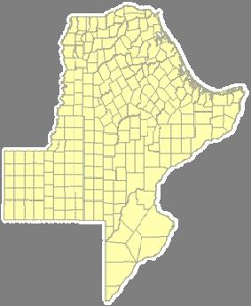
25 Pilot Studies Pilot implementation at WSDOT Focus on FDEs plus additional state data Focus on intersections, intersection legs, and ramps Pilot implementation at MODOT Focus on FDEs Focus on intersections, intersection legs, and ramps Special interest in local data integration 25
26 Process Adapt tool to create generic version for implementation at other states Created MIRE data model Developed extensive documentation Conduct implementation meetings Modify tools, submit, collect feedback 26
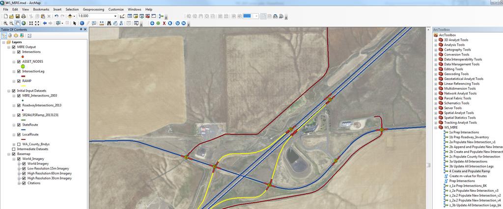

27 WSDOT Implementation 27
28 Live Demonstration 28
29 RDETAP Future Steps Further refine documentation, incorporating lessons learned from pilot studies Develop and distribute two guides Programmer guide focused on implementation User guide focused on tool usage and features Provide technical assistance to additional agencies Consider potential tool enhancements Road segments, interchanges, horizontal curve, vertical grade 29
30 RDETAP Team Contact Information Role Name Agency Phone FHWA COTM Bob Pollack FHWA (202) Principal Investigator Edgar Kraus TTI (210) Ext e kraus@tti.tamu.edu Task Manager Brett Graves Leidos (703) brett.o.graves@leidos.com Additional Team Members TTI: Jerry Le CTRE: Omar Smadi, Zachary Hans Leidos: Brian Chandler 30
31 Thank You! 31