Webinar Series for Comprehensive Plan Updates. Transportation Overview
|
|
|
- Camilla Blake
- 5 years ago
- Views:
Transcription
1 Webinar Series for Comprehensive Plan Updates Transportation Overview Presented by Michael Larson and Mark Filipi August 18, 2016

2 2040 Transportation Policy Plan Adopted January 14 th, 2015 Multimodal Federal Requirements Updated every 4 years Fiscally constrained Basis for System Statements

3 Current Revenue Scenario Highway Projects
4 Planning is a Continuous Process All metro communities have previous comp plans- much of the regional transportation plan is probably already in your plan What s new in the 2040 TPP Minimum requirements for your Comprehensive Plan to be considered complete

5 Highways and Roads
6 Functional Classification Road Function Defined by Mobility and Accessibility High Principal Arterials Mobility Minor Arterials Collectors Local Streets Low Low Accessibility High

7 Functional Classes Principal Arterials Minor Arterials Augmentor Reliever Expander Connector Other Collectors Major Minor
8 Plans Must Show Functional Classification Current functional classification can be found on your Community Page in the Local Planning Handbook Changes must be submitted separately to the Transportation Advisory Board (TAB) (Contact Elaine Koutsoukos, )
9 Road Plan Requirements For Principal Arterials and Minor Arterials: Current Average Daily Traffic (ADT) and Heavy Commercial Average Daily Traffic (HCADT) Forecast 2040 traffic volumes Existing and future number of lanes Future rights-of-way to be preserved Planned improvements to PAs as shown in Current Revenue Scenario of the TPP Existing or proposed MnPASS lanes, dedicated busways and bus-only shoulder lanes
10 Roadway Plan Requirements Proposed interchange improvements must follow the Highway Interchange Request Criteria and Review Procedure found in Appendix F of the TPP Access management guidelines (available from MnDOT or your county) Recommendations from recent corridor studies


11 Areas with High Traffic Generation Include analysis of travel demand management strategies These areas include: Downtown Minneapolis Downtown St. Paul University of Minnesota Bloomington: Airport South/Mall of America

12 Travel Demand Forecasting Transportation Analysis Zones Travel Forecasts
13 Socio-Economic Data by Transportation Analysis Zones Needed to produce travel demand forecasts Allocate forecast growth of population, households, and employment to TAZs within your community Allocate data for 2020, 2030, and 2040 Use new Transportation Analysis Zone (TAZ) system developed for 2010 travel demand model update
14 Socio-Economic Data by Transportation Analysis Zones Allocate growth based on your plan s guided future land use Accommodate development densities around transit consistent with density expectations in TPP s Transit Plan
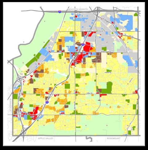
15 Travel Demand Forecasts Forecast method determined by growth and land use change expectations Regional Travel Demand Forecast Model Local Travel Demand Forecast Model Projections based on historical data
16 Travel Demand Forecasts New Regional Travel Demand Model Activity Based/Tour Based Model Use of a model other than the standard Regional Travel Demand Forecast Model must be documented If local model is used, consistency with regional model must be documented Projections from historical data may only be used in areas displaying slow, gradual change Work with Met Council travel forecasting staff

17 Transit and Transitways


18 Transit Planning Transit Market Areas Existing Transit System Planned Transit System
19 Transit Market Areas Population and employment density Intersection density Car ownership


20 Transit Market Areas Population and employment density Intersection density Car ownership

21 Transit Capital Levy District
22 Transit System Existing transit routes and dial-a-ride services Existing and potential high-frequency transit routes Existing and planned transit stations and transit centers Existing and planned park-and-rides and express bus corridors Existing and planned transit advantages Existing transit support facilities

23 Transit System

24 Transit System

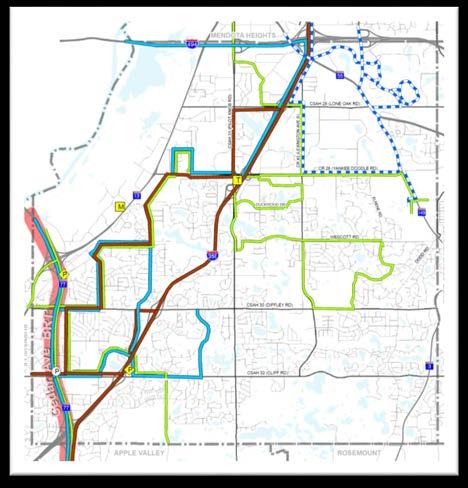
25 Current Revenue Scenario

26 Current Revenue Scenario

27 Current Revenue Scenario - Density

28 Current Revenue Scenario - Density

29 Increased Revenue Scenario

30 Planned Transit System Bloomington Desired Transit Improvements and Land Use Transit Relationships and Transit Support

31 Transit Market Areas

32 Bicycles and Pedestrians

33 TPP Bicycle Plan Changes Regional Bicycle Transportation Network (RBTN) Regional Bicycle System Study results Includes guidance on funding prioritization criteria for regionally-allocated transportation funds
34 Goal of a Regional Bicycle Transportation Network Establish an integrated and seamless network of on-street bikeways and off-road trails to: Improve conditions for bicycle transportation at regional level Encourage planning/implementation of future bikeways by cities, counties, parks agencies, and the state to support this regional vision

35 Regional Bicycle Transportation Network
36 RBTN Benefits Provides stronger connections to regional destinations Guides cities/counties in making cost-effective investments Extends reach of community bicycle systems Improves missing links between jurisdictions
37 TPP objectives & strategies Providing access to regional destinations Improving facilities for safe walking and biking Improving multimodal travel options for all ages & abilities Increasing bicycling and walking mode shares Improving continuity of bikeways between jurisdictions Improving connections across physical barriers Encouraging land use design that uses Complete Streets principles
38 Bicycle Plan Requirements Describe and map existing and planned onroad and off-road bicycle facilities Map and describe the RBTN relative to your local network A new interactive Regional Bicycle System Inventory database will be made available. More info- RBTN & Regional Trail System webinar

39 Pedestrians Analyze and address needs Facility improvements Safety Connections Remove barriers Discuss pedestrian system needs in a manner that responds to your community designation and addresses the needs of your community.

40 Aviation System

41 Regional Aviation System
42 TPP Aviation Themes Airport Expansion will be limited Preserve and manage the airport system Balance demand and capacity - to reflect land use compatibility & transportation connection
 (Form 7460-1)")
43 Required Elements (ALL local government units) Protect Region s General Airspace Objects potentially affecting navigable airspace Notification to the FAA (Federal Aviation Administration) (Form )
44 Required Elements (Communities directly impacted by an airport) Reflect Approved Airport Long Term Comprehensive Plan (LTCP) in the Community Plan Include: Map of the airport location with runways Existing and future airport boundaries Land access locations Describe Existing and future operational characteristics for airports whose compatibility area includes your community.
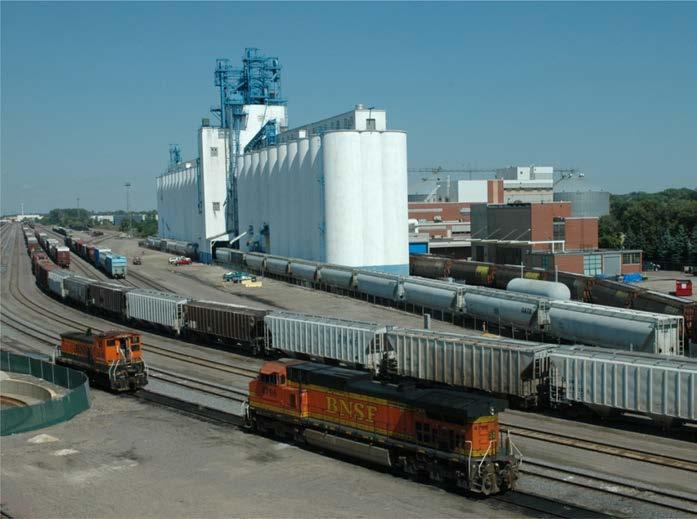
45 Freight

46 Freight Considerations in Comprehensive Plans Freight uses multiple modes, trucking is predominant Important to acknowledge major freight centers and to plan for connections to those centers
47 Freight Considerations in Comprehensive Plans Minimum requirements include: Identify railways, barge transfer facilities, and truck or intermodal freight terminals. Identify other important freightgenerating centers. Map volumes of heavy commercial trucks for Principal and A-Minor arterials.
48 Freight Considerations in Comprehensive Plans Other important issues for local plans to include: Identify any local roadway issues or problem areas for goods movement. Plan for and identify truck routes for semi trucks. Complete Streets improvements that may coincide with important truck routes Consider truck access in mixed use developments
49 Resources /Key-Transportation-Planning- Documents/Transportation-Policy-Plan-(1).aspx
50 Questions? Mark Filipi, Manager, Metropolitan Transportation Services Michael Larson, AICP, Senior Planner Connie Kozlak, AICP, Planning Analyst
51 Upcoming Events Making your Plan a Walk in the Park Presented by Jan Youngquist and Michael Peterka Thursday, September 15, 2016 Transit Planning Basics, Market Areas, and Comprehensive Planning Presented by Cole Hiniker and Michael Mechtenberg Thursday, September 22, 2016 Local Planning, the Regional Bicycle Transportation Network & Regional Trails Presented by Steve Elmer and Jan Youngquist Thursday, October 13, 2016