Appendix O Congestion Management Program REGIONAL TRANSPORTATION PLAN/SUSTAINABLE COMMUNITIES STRATEGY
|
|
|
- Alisha Bishop
- 5 years ago
- Views:
Transcription
1 Appendix O Congestion Management Program REGIONAL TRANSPORTATION PLAN/SUSTAINABLE COMMUNITIES STRATEGY
2 2014 REGIONAL CONGESTION MANAGEMENT PROGRAM 2014 RTP/SCS APPENDIX O SAN JOAQUIN COUNCIL OF GOVERNMENTS 555 E Weber Ave., Stockton CA 95219
3 INTRODUCTION Congestion management is an integral element of the region s transportation planning and programming process. It serves as a guide for implementing both near-term and long-term regional transportation improvements. The Safe, Accountable, Flexible, Efficient Transportation Equity Act: A Legacy for Users (SAFETEA-LU), signed into law on August 10, 2005 requires transportation management areas (TMAs), such as San Joaquin County, to develop and engage in a Congestion Management Process (CMP) that is fully integrated into the regional transportation planning process in order to provide for safe and effective integrated management and operation of the transportation system The CMP requirement was recently carried forward with the current Federal transportation authorization act, Moving Ahead for Progress in the 21st Century (MAP-21). SJCOG also functions as the County s Congestion Management Agency and is required to develop a Congestion Management Plan (CMP) pursuant to California Government Code Section and update it every two years. The Federal Highways Administration defines the congestion management process as a systematic approach... that provides for effective management and operation, based on a cooperatively developed and implemented metropolitan-wide strategy, of new and existing transportation facilities eligible for funding under title 23 U.S.C., and title 49 U.S.C., through the use of operational management strategies. In compliance with the federal and state congestion management directives to support regional mobility, SJCOG has developed, and implements, the Regional Congestion Management Program (RCMP). SJCOG s RCMP is integrated into the RTP/SCS and FTIP process as a unified response to reducing congestion in our region. The RTP/SCS and RCMP support a multimodal approach to transportation that looks at the overall system and improvements that benefit all modes, rather than prioritizing one over the other. The goal of this approach is to provide choices to all of the transportation system s users. The RCMP is part of SJCOG s integrated approach to improving and optimizing the transportation system and providing for the safe and effective management of the regional transportation system through the use of monitoring and maintenance, demand reduction, land-use, operational management strategies, and strategic capacity enhancements. As described within the Guidebook for the Federal Congestion Management Process, implementing a CMP that supports livability involves a more holistic approach striving for well-rounded management of the transportation system that includes consideration of multiple goals, including economic vitality, safety, multimodal choices, and the environment. By placing more focus on demand management and operations strategies, the RCMP can help to preserve existing infrastructure, support existing communities, and improve multimodal travel choices. The Regional Congestion Management Program components outlined in this appendix are: Relationship of RCMP with RTP/SCS Objectives Performance Measures 1
4 Regional Network Transportation Monitoring Program Travel Demand Management Land Use Strategies Regional Goods Movement Strategies The complete Congestion Management Program Plan is available at RELATIONSHIP OF SJCOG RCMP AND REGIONAL TRANSPORTATION PLAN/SUSTAINABLE COMMUNITIES STRATEGY As described above, all federally designated Transportation Management Areas (TMAs) are required to develop and implement a Congestion Management Process as part of the metropolitan planning and programming process. SJCOG s Regional Congestion Management Program (RCMP) supports the MPO s development of transportation investment strategies though bringing technical objectivity to the planning & programming process and is an important tool for to assist the decision-makers in determining priorities for project implementation and funding, both near as well as long-term. Monitoring is a key mechanism of the RCMP that feeds into the regional transportation planning/programming process during RTP and FTIP updates. The RCMP involves extensive data and information collection on the regional transportation system which feeds directly into a set of performance measures used for assessing, monitoring, and maintaining the performance of the multimodal network. The outputs of the CMP process are important to the long-range transportation planning process. The 2012 RCMP establishes strategies to combat congestion and its impacts on economic development must focus on a broad set of supply side and demand side strategies that embrace the latest thinking about reducing SOV trips, coordinated investment in alternative modes of transportation, and new incentives for getting people out of their cars. Included among these strategies are the following: Implementation of the Land Use Analysis Program (LUAP) that evaluates all discretionary land use projects for impacts of land use decisions made by local jurisdictions relative to the transportation system. The intent of the LUAP is to improve the linkage between land-use decisions with regional transportation facility improvement needs through strategies that promote a mix of uses, greater density, less parking, and direct investment in transit, walking and/or biking. Detailed monitoring of designated Multimodal Corridors (MMLOS Corridors). Pedestrian, bicyclist, transit passenger, and motorist levels of service are analyzed on these corridors to allow a more meaningful and focused RCMP multimodal performance measure tracking mechanism. It will also provide greater flexibility to local agencies for identifying improvement strategies on deficient roadways, which is applicable to corridors where lane capacity improvements to 2
5 improve vehicular level of service may be infeasible or undesirable due to high costs, limited right-of-way, and/or institutional constraints. Multimodal performance measures with specific standards that set targets for improving transit, walking, and biking throughout the county, as well as facilitating SJCOG s Employer-Based Trip Reduction Program, Commute Connection. Measurable monitoring goals to curtail substandard performance on the RCMP roadway facilities and intersections. Table 1 shows the supporting relationship between the RCMP s performance measures and the goals and objectives of the 2014 RTP/SCS. Additionally, TMAs that are designated as non-attainment or maintenance areas for ozone or carbon monoxide, federal regulations require that projects resulting in a significant increase in SOV carrying capacity (with the exception of safety improvements and bottleneck elimination projects) be identified or addressed through a well-defined congestion management process. For capacity increasing projects on the regional network that are scheduled for completion within the next ten years (by 2024), SJCOG has prepared a qualitative scoring matrix (RCMP Project Matrix, Table 2) that looks at several operational, multimodal, and programming factors for the project s consideration within the RTP. In making transportation investment decisions, the RCMP Project Matrix (as well as other technical data collected through the RCMP) is used in conjunction with a wide range of other factors, such as quality of life and livability. As these projects move forward to the FTIP, SJCOG will continue to meet the intent of this directive through coordination the project sponsors to ensure travel demand reduction and/or operational management strategies are addressed. These program strategies, together with the implementation of the comprehensive congestion management program, support the latest industry efforts to reduce traffic congestion while promoting sustainable communities that rely less on the SOV for their growth and continued economic development. OBJECTIVES AND PERFORMANCE MEASURES Establishment of multimodal performance measures is both a state and federal CMP requirement. Section 65089(b)(2) of the Government Code states that the Congestion Management Program (CMP) must contain a performance element that includes performance measures to evaluate current and future multimodal system performance for the movement of people and goods. These performance measures shall support mobility, air quality, land use, and economic objectives. Federal directives outlined in 23 CRR (b) require the congestion management process result in multimodal system performance measures and strategies that can be reflected in the 3
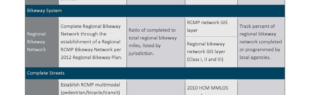
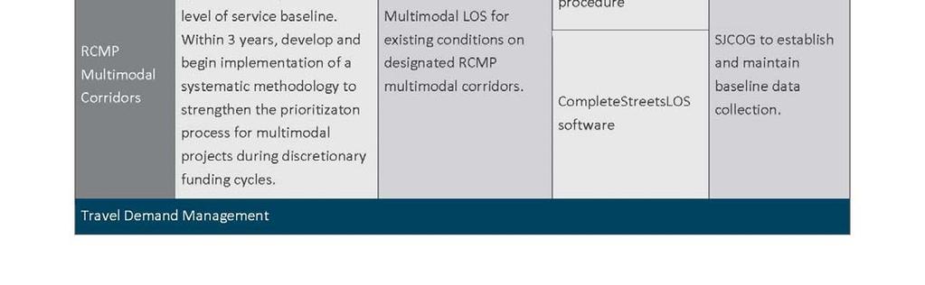
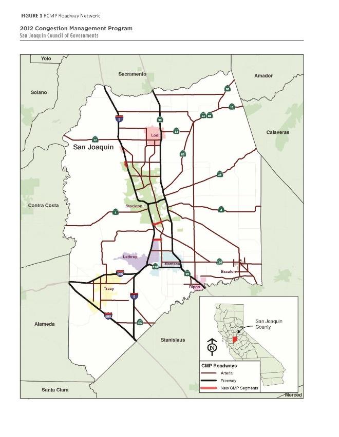
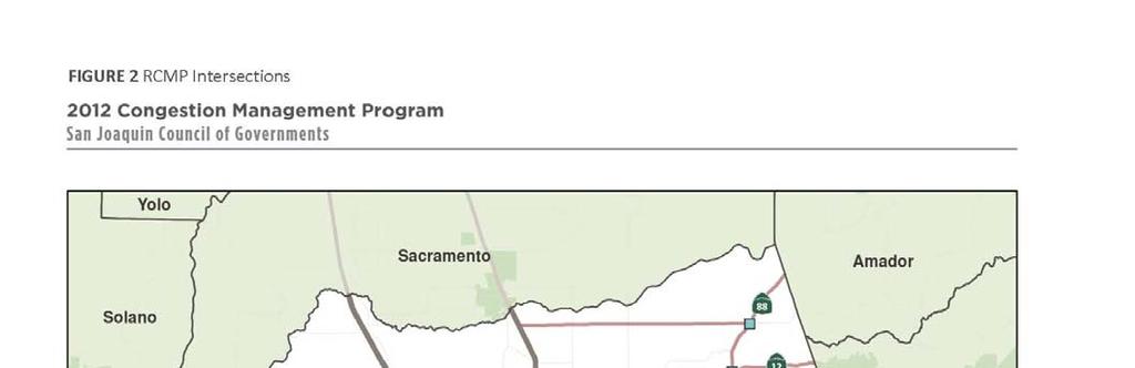
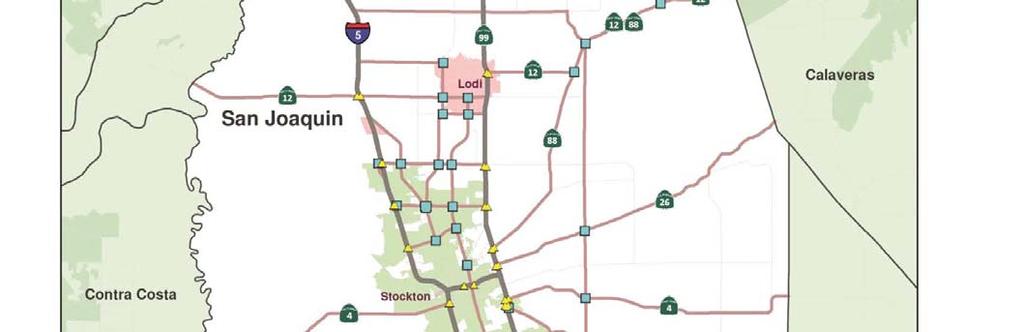
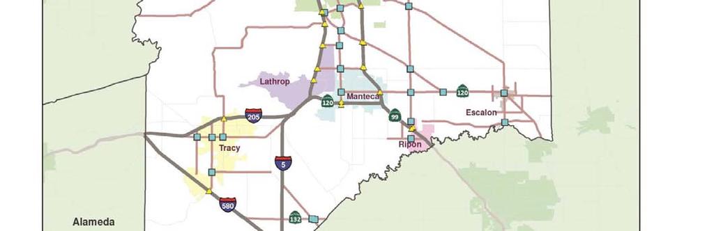
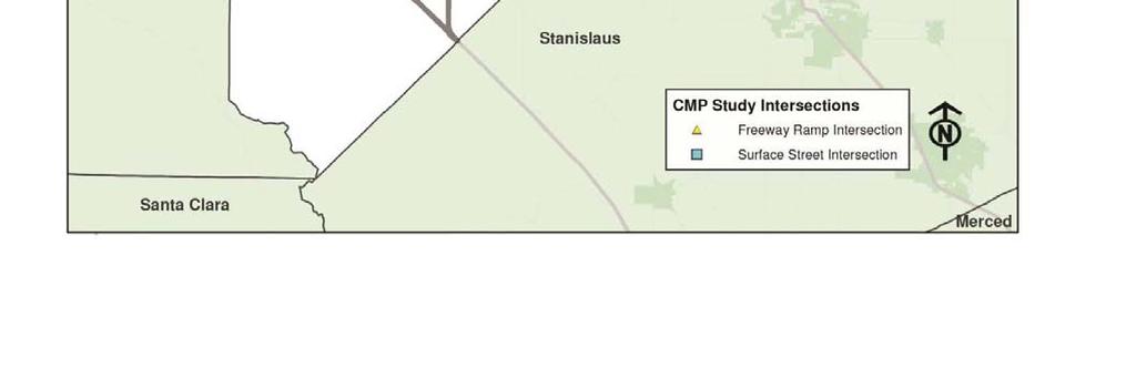
6 regional planning documents, such as the Regional Transportation Plan (RTP) and Transportation Improvement Program (TIP). In order to provide viable choices to Single-Occupant Vehicles (SOVs) and to support the intent of Federal MAP-21 legislation, SJCOG has made the Congestion Management Process an integral part of the regional transportation planning process, including the Regional Transportation Plan (RTP) and the Federal Transportation Improvement Program (FTIP). The RCMP tracks and monitors several performance indicators that are used to: Track progress toward meeting RCMP objectives; Update SJCOG s Regional Transportation Plan (RTP) and aid project prioritization; Determine Statewide and Federal Transportation Improvement Program (STIP/FTIP) projects; and, Guide Regional Transportation Improvement Fee (RTIF) funding decisions. The 2012 RCMP objective and performance measures are shown in Table 3. As RCMP program implementation continues, refinement of these measures and/or additional performance measures will be established as part of future updates. REGIONAL TRANSPORTATION SYSTEM The purpose of the Regional Congestion Management Program (RCMP) is to monitor congestion, identify congestion problems, and establish a programming mechanism aimed at reducing congestion. Designation of a regional transportation system supports RCMP monitoring activities and focusses the implementation of the RCMP on a core network of key transportation facilities that facilitate regional travel within San Joaquin County. RCMP Roadway Network State statute requires that all state highways be designated as part of the RCMP roadway network. The inclusion of locally owned and operated principal arterials is left to the Congestion Management Agency (CMA), in coordination with its member agencies. Chosen local arterials must represent routes of regional significance. Per state statute, once a route is designated as part of the RCMP system, it cannot be removed. In addition, all new state highways and principal arterials must be included in the RCMP system. SJCOG has developed a regional bikeway network as part of the Bicycle, Pedestrian, and Safe Routes to School Plan. The network establishes routes of regional significance for bicyclists. There are many other elements that create a supportive environment for bicycling, including bikeway types, parking, shower and locker facilities, and wayfinding signage which are best addressed in the Regional Transportation Plan. The RCMP performance measure will focus on the bikeway network s completion. The San Joaquin County RCMP roadway network is shown in Figure 1. RCMP Roadway Network Intersections With the 2012 program update, a total of 103 intersections within the incorporated and unincorporated areas of San Joaquin County have been designated as part of the RCMP network. 4

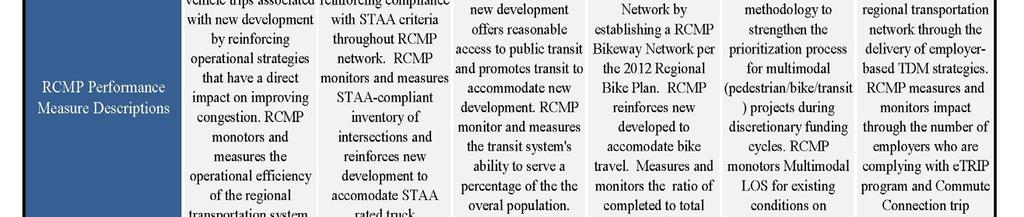
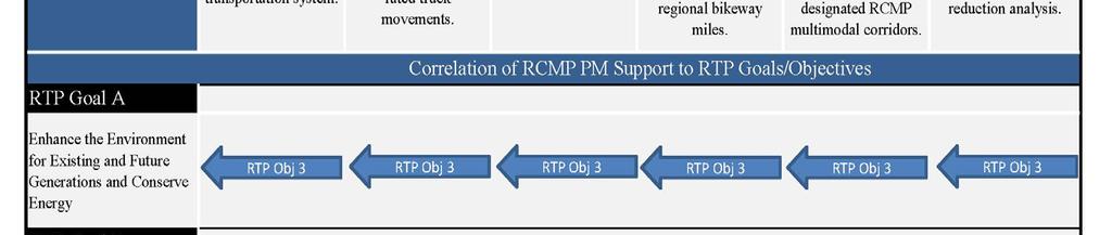
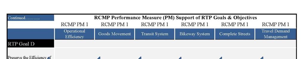
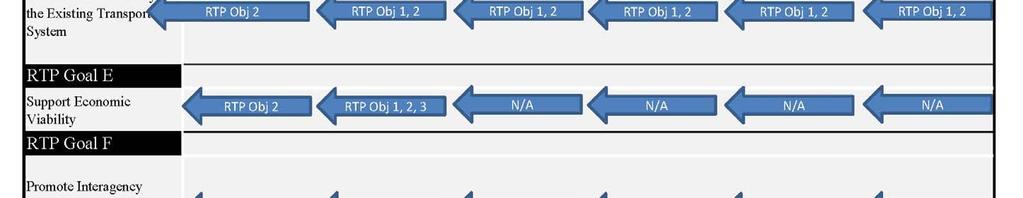
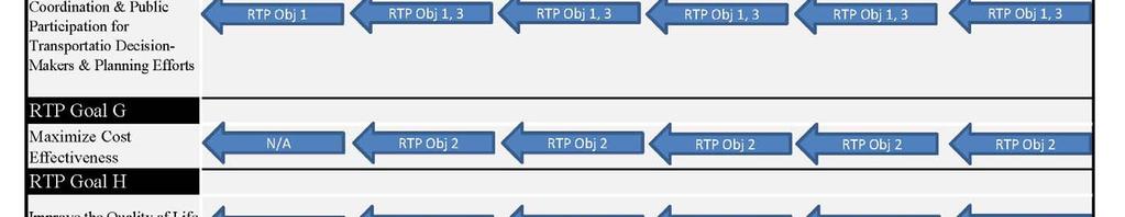
7 TABLE 1 RCMP PM Relationship to RTP Goals/Objectives 5
8 6
9 TABLE 2 RCMP SOV CAPACITY INCREASING PROJECT REVIEW MATRIX 7
10 8
11 9
12 10
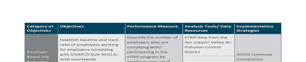
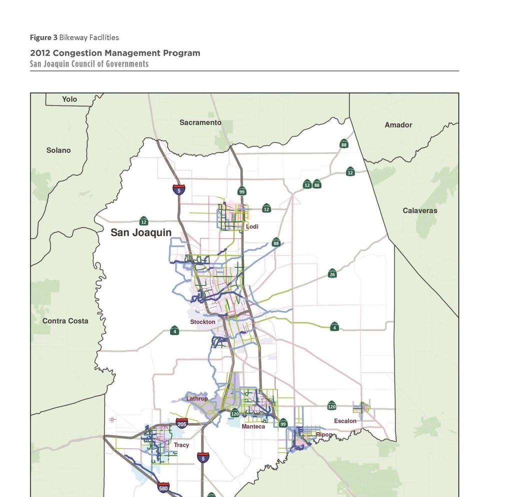
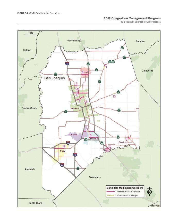
13 Designation of RCMP intersections adds resolution for congestion monitoring and appropriately focusses attention at locations where operational constraints are typically experienced on arterial roadways. RCMP intersections are shown in Figure 2. RCMP Bicycle Network The provision of bicycling facilities is an important component of the SJCOG s program to encourage multimodal transportation. SJCOG has developed the Bicycle, Pedestrian, and Safe Routes to School Plan. A key deliverable of this plan is the formal designation of a regional bikeway network. This regional bikeway network includes existing and future Class I Multi-use trails, Class II Bike Lanes, and Class III Bike Route facilities that will comprise a continuous uninterrupted network of facilities across the entire county. The regional bikeway network provides a mechanism for tracking performance and ultimate completion of the bikeway network. RCMP bikeway facilities are shown in Figure 3. RCMP Multimodal Corridors State and federal mandates require the consideration of all major modes of travel as part of a Congestion Management Program (CMP). Additionally, the California Complete Streets Act (AB 1358) requires counties and cities to include policies that take all roadway users into consideration (bicyclists, pedestrians, transit riders, motorists, children, senior citizens, mobility impaired, and freight movers) as part of their general plan updates. In recognition of these legislative mandates, SJCOG, in coordination with its member agencies, established Multimodal Corridors. These corridors are generally located in areas that are characterized by a predominance of shared roadway users (pedestrians, bicyclists, transit passengers, and motorists) and where roadway widening is infeasible or undesirable. These corridors are not the only roadways on the RCMP that need to accommodate multiple user types. All RCMP roadways with adjacent land uses need to provide access for all user types. However, these designated Multimodal Corridors will receive the benefit on level of service analysis for all travel modes. RCMP multimodal corridors are shown in Figure 4. TRANSPORTATION DEMAND MANAGEMENT Transportation Demand Management (TDM) is the all-inclusive term given to a variety of measures used to improve the efficiency of the existing transportation system by managing travel demand, including carpooling, transit, High Speed Rail, telecommuting and nonmotorized transportation. SJCOG has established countywide programs to address demands for transportation, embodied in the Commute Connection. The main purpose of the demand management program is to reduce the number of singleoccupant vehicles during peak demand times by providing incentives for carpooling, taking transit, walking, biking, or traveling off-peak. These programs are documented in SJCOG s Travel Demand Management Plan, adopted in San Joaquin County is also part of the San Joaquin Valley Air Pollution Control District (SJVAPCD), which has introduced a mandatory trip reduction program for 11
14 businesses that employ 100 or more full time employees. Table 3 details the two performance measures for travel demand management: Employer-Based Trip Reduction Programs Local Agency Efforts Employer-Based Trip Reduction Programs This measure is designed to quantify participation by all employers located in San Joaquin County in employee trip reduction programs such as San Joaquin Valley Air Pollution Control District s (SJVAPCD) etrip program. Local Agency Efforts This measure is designed to track local jurisdictions participation in implementing their Travel Demand Management responsibilities as defined in SJCOG s 2010 Regional Travel Demand Management Plan The level of effort is based on the level of congestion on a given jurisdiction s RCMP roadways with particular focus placed on roadways that are currently not meeting the RCMP LOS Standard. Level 1 is a required minimum effort to be implemented by SJCOG and each of its member agencies. The purpose of the Level 1 Effort is to formalize the existing working relationship SJCOG currently has with its partner agencies and further refine existing TDM related activities currently being implemented countywide. Level II requirements will be required in response to measured levels of congestion on the RCMP network, referred as the RCMP Congestion Threshold. The Congestion Indicator is a threshold comprised of the following two checks: 1) when over 30% of a jurisdiction s RCMP lane miles (or intersections) operate at LOS E or worse without programmed improvements; and, 2) if over 30% of the traffic on these segments is determined to be generated within the jurisdiction. If both these conditions are met, a sub-regional Travel Demand Model Action Plan is required. Integrating TDM planning efforts relative to CMP roadway network performance provides an equitable nexus between degree of TDM responsibility and fair share contribution of local traffic. SJCOG determines local agency compliance with the Regional TDM Plan as part the RCMP biennial review. SJCOG will also track implementation of Commute Connection Program initiatives and the 2010 Regional Travel Demand Management Program through the RCMP Land Use Analysis Program. LAND-USE STRATEGIES The RCMP s Land Use Analysis Program (LUAP) supports the region s planning efforts to promote high quality multimodal transportation choices for future sustainable development through improving the linkage between local land-use decisions with regional transportation facility improvement needs; to better address the impacts of development in one community on another; and, to promote information sharing between local governments when the decisions made by one jurisdiction have an impact on another.. As part of the annual Measure K and biennial state CMP reporting requirements, SJCOG is 12
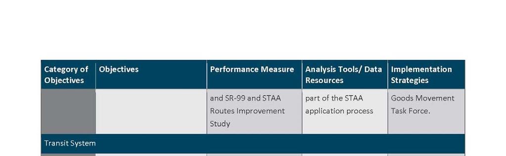
15 required to evaluate the efforts made by each local jurisdiction within San Joaquin County to ensure compliance with Land Use Analysis Program (LUAP). Detailed description of the RCMP s LUAP is contained within Chapter 6 of the program plan, including impact criteria and, mitigation policies. GOODS MOVEMENT STRATEGIES The movement of goods throughout San Joaquin County is crucial to the economic health of the region. Freight traverses the county using many modes, including trucks, rail, and ship. Trucks, however, are the predominant mode of goods transport in the county, and the focus of a performance measure for tracking RCMP roadways that are Surface Transportation Assistance Act (STAA) compliant. The Surface Transportation Assistance Act (STAA) was passed in 1982 by the federal government to govern the movement of trucks and trailers. STAA vehicles are large commercial trucks that meet federal size regulations (48 to 53 feet from kingpin to rear-axle). In California, the STAA network consists of the National Network (generally, interstate freeways and approved state highways) and Terminal Access (state highways). Roadways that are part of the STAA network must be designed to accommodate the STAA-sized trucks. As part of performance monitoring SJCOG tracks improvements to intersections listed in the Interregional Truck Operations on I-5 and SR-99 and STAA Routes Improvement Study through coordination with local agency STAA applications. SYSTEM MONITORING PROGRAM The program s network consists of all freeways, state highways, principal arterials, over one-hundred intersections, as well as the transit, bike, and pedestrian systems. Through the implementation of the RCMP s System Monitoring Program, SJCOG collects regionwide transportation data and monitors the performance of the multimodal network. The program deliverables also provide valuable data to the local jurisdictions and to the state Department of Transportation, Caltrans for their individual planning needs The RCMP Monitoring Program provides the mechanism to yield the requisite traffic counts and related data and methodologies to address the state RCMP vehicular LOS standards and the established multimodal state/federal performance measures). It addresses multiple analysis scales and RCMP system components (corridor, segment, intersection). 13


16 TABLE 3 RCMP SOV CAPACITY INCREASING PROJECT REVIEW MATRIX 14
17 15

18 16
19 17
20 18
21 19
22 20