The Map American Intercity Bus Riders Association National Intercity Services Map
|
|
|
- Janice Stevens
- 5 years ago
- Views:
Transcription


1 The Map American Intercity Bus Riders Association National Intercity Services Map Michael Buiting President American Intercity Bus Riders Association
2 The Map Only comprehensive national map of intercity surface bus and rail passenger services Includes routes, carriers, stops Updated frequently from multiple sources CAD-based
3 Initial (2007) Inspirations No nationwide intercity bus service citizen advocacy group, despite both long-term and recent reductions in rural services No readily available comprehensive nationwide intercity bus map or data Available information was often dated, hard to find, or partial (one carrier, one state, etc.)
4 Key Map Parameters Comprehensive, inclusive and unbiased-no corporate or organizational sponsor that might wish to exclude other carriers or non-members Lower 48 states only does not include Alaska and Hawaii Only interconnected intercity bus service and Amtrak is included No air or water transportation, no commuter rail
5 Rules for Inclusion Route and schedule information must be available through a public forum (i.e. internet), service available to the general public Fixed-route, fixed-schedule service Minimum frequency for inclusion is twice a week, 52 weeks per year (no seasonal, special event/venue services) Carrier must be regional and interconnected no local service Interconnected if stops are within corporate boundaries of same jurisdiction Interline ticketing and shared stations not required
6 Website Includes The map itself Update list, by date and location Find a Station state by state tables of intercity bus stops and carriers serving them Airport Links scheduled intercity service to most major US airports
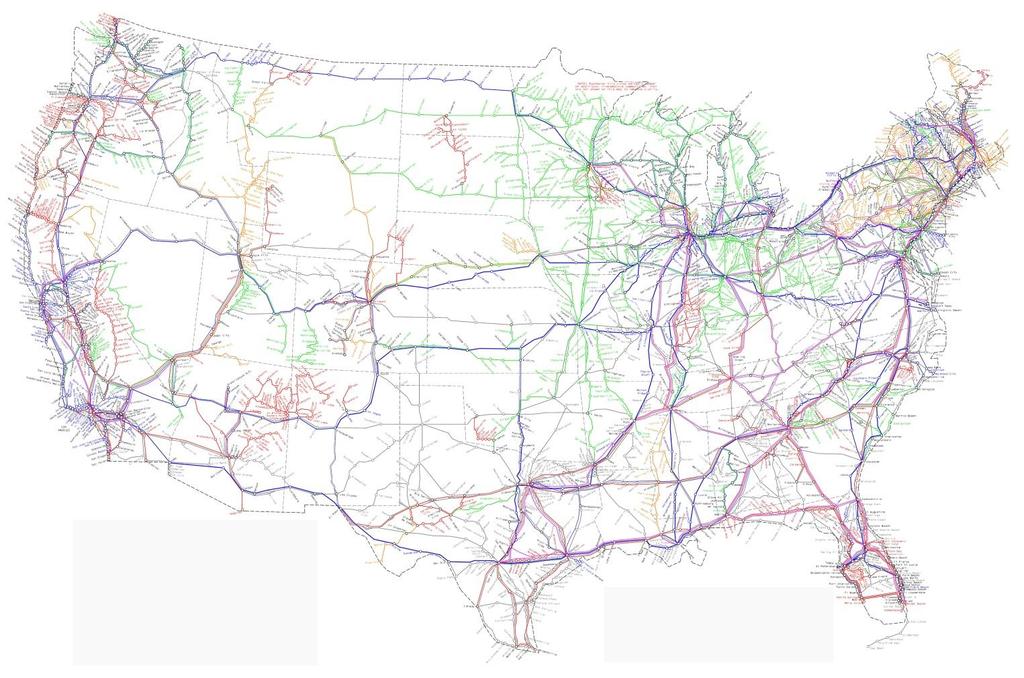
7 The Map
8


9 Example of State Service Table North Carolina A-K
10 Unserved Areas Unserved Areas updated list/map of locations with populations over 25,000 located more than 25 miles from the nearest scheduled intercity, regional transit, bus or train stop Analysis of impact of potential links in reducing unserved areas
11 Potential Benefits Potential passengers can easily see if their trip origins and destinations are served, and by which carriers As a policy and planning tool it shows coverage of existing services and connectivity (existing and potential) Provides information about small/regional carriers Also shows isolated areas that might be addressed by Section 5311(f) or other new services
12 Website Challenges Map is in CAD system, not GIS Routes not linked to particular roads, station addresses not included No ability to attach other data such as population characteristics Awkward to update, busy, very large files Updating, while continuous, is happenstance Personnel and resources to maintain and develop are limited completely volunteer effort!
13 The Future Website and map needs to be brought into GIS to support policy and planning use Map and inventory needs a permanent, funded home to provide for: Continuing updates to the information Enhanced public access (searchability, etc.) Linkages to local transit maps (GTFS, etc.) Technology upgrades
14 My goals for intercity service development Expansion of Section 5311(f) services to include more multi-state connections (improving coverage and connectivity) Expansion of Section 5311(f) program to support interlined/connected regional services One-stop ticketing and information for the entire intercity bus and Amtrak network
15 Credits God for giving me the idea and will to create the website, and helping me to keep it going with as few problems as it has had My wife s son John Mongillo who initially built the website and HTML codes KFH Group for providing a platform when website traffic spiked and I needed the capacity Update information providers such as Mark Szyperski, David Sucha, Stephanie Gonterman, John Corey, etc.
16 Final comments The bus is the easiest form of public transportation to use to build intermodal links The bus can be used to quickly and cheaply build a corridor between major cities while also providing for stops in rural communities It has been a pleasure getting to know the intercity bus industry and its professionals Thank you very much!
17 Contacts: The site: My