Operational Analysis of Dulles Toll Road Ramps to Tysons. Board Transportation Committee Meeting September 17, 2013
|
|
|
- Beverly Page
- 5 years ago
- Views:
Transcription

1 Operational Analysis of Dulles Toll Road Ramps to Tysons Board Transportation Committee Meeting September 17, 2013 Seyed Nabavi Fairfax County Department of Transportation 1
2 Agenda Overview & Assumptions Traffic Analysis Comparison of Options Timeline, Other Projects Questions & Comments 2
3 Overview Tysons Comprehensive Plan Amendment Approval June 2010 Evaluate the feasibility of the three general ramp locations included in the comprehensive plan amendment DTR West of Route 7 DTR between Route 7 and Spring Hill Road DTR East of Spring Hill Road 3
4 Overview, Tysons Transit, Growth and A Comparison to other Jurisdictions The future transit goals for Tysons are very aggressive. Even in New York City, new developments will result in additional vehicle trips. 4
5 Assumptions All Options include: Comp. Plan Table 7 Improvements Widening of I-495 (including HOT Lanes/Connections) Extension of Boone Blvd Widening of Route 7 Jones Branch Connector / Scotts Crossing Extension Grid of Streets Assumes 60% of the Grid is in place in 2030 No Build Scenario does not include: Collector-Distributor (C-D) Road or Urban Frontage Road Any of the three Ramp Options: Boone Boulevard Ramp Greensboro Drive Jones Branch Ramp 5

6 2030 No Build 2030 Base Network, Includes Table 7 Improvements and Some of the Grid of Streets 6
7 Option 1 Boone Blvd. Ramp (one lane in and one lane out), Greensboro Drive Ramp and Jones Branch Ramp, Includes CD Road 7
, Urban")
8 Option 2 Boone Blvd. Ramp (one lane in and one lane out), Urban Frontage Roads and Jones Branch Ramp 8
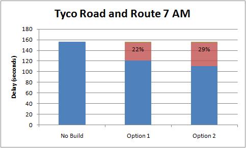
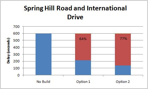
9 Key Intersection Summary (AM) 9

10 Key Intersection Summary (PM) 10
11 Advantages Option 1 Option 2 Boone Blvd Ramp, Greensboro Dr Ramp, & Jones Branch Ramp with C-D Road Less costly Functions similar to other highway/freeway connections Driver expectation; exit/entrance ramps are similar to others in the area Separation of thru and ramp traffic Higher design and travel speeds Mostly at-grade Phased construction of the ramps possible Boone Blvd Ramp, Urban Frontage Roads, & Jones Branch Ramp Compatible with the highly urbanized vision Distributes traffic to two points between Route 7 and Spring Hill Road Provides a transition between higher speeds on the DTR and slower speeds within the grid of streets More bicycle and pedestrian friendly Provides additional access to the east on the DTR 11
12 Disadvantages Option 1 Option 2 Boone Blvd Ramp, Greensboro Dr Ramp, & Jones Branch Ramp with C-D Road Loads traffic into a single intersection along Tyco Road Includes another higher speed ramp (Greensboro) tying into the grid Greensboro ramp encroaches more toward the residential areas to the north Less bicycle and pedestrian friendly Does not provide additional access to the east on the DTR Boone Blvd Ramp, Urban Frontage Roads, & Jones Branch Ramp More expensive due to the structures More difficult to phase construction Relies on signalized intersections to function More significant visual impacts due to the DTR overpasses 12
13 Comparison Table Alternative Option 1 - Boone Blvd Ramp, Greensboro Dr Ramp, & Jones Branch Dr Ramp with C-D Road Option 2 - Boone Blvd Ramp, Urban Frontage Roads, & Jones Branch Dr Ramp Improvement to Route 7 Intersection Operations (AM / PM) Improvement to Spring Hill Intersection Operations (AM / PM) Improvement to Grid of Streets Intersection Operations (AM / PM) Impacts to Merging / Weaving along DTR Estimated Increase in Impervious Area, SF Estimated ROW & Permanent Easement Areas, SF Environmental Estimated Construction Cost Medium / No Significant 1,550, ,000 Medium Difference $250 Million Between the Low / Low Low / Medium Low / Low Two Options, Will be Studied Medium / High 1,560, ,000 Further in More Detail $330 Million NOTE: Estimated cost to construct the ramps and C-D/urban frontage roads included in each option. Costs are in 2013 dollars. The costs were computed using the VDOT Transportation & Mobility Planning Division, Statewide Planning Level Cost Estimates and supplemented where costs were not provided. Due to the space constraints throughout the project corridor, the retaining walls were assumed to be MSE walls. The costs do not include ROW, utilities, drainage, stormwater management, environmental mitigation, or the reconstruction of impacted bridges or MWAA facilities, as these costs are expected to be similar for both options. Traffic Both options improve intersection LOS and reduce delay Environmental Impacts Noise, Visual, Air, Park Land, Waterways Will be quantified further in future studies 13
14 Other Strategies that Can be Considered to Improve Operations Active Traffic Management Main Line Speed Harmonization Open Road Tolling Ramp Metering (Route I-66 in Arlington) Increase Capacity to Toll Road/Access Road Congestion Pricing Improve Transit Network 14
15 Stakeholders Outreach Monthly progress meetings with VDOT, MWAA, and FCPA. Tysons steering committee meetings Planning commission meetings Meetings with Dominion Virginia Power Meetings with FCPA and EQAC Two public information meetings Community meetings Meetings with Tysons west developers and property owners as part of Tysons west CTIA Study Meetings with property owners/developers adjacent to the proposed ramps 15
16 Next Steps Document all comments received October 2013 Finalize report November 2013 Present Board action item December 2013 Monitor Tysons development and growth Monitor studies and improvement projects in the area DTR Corridor Study (Dulles Airport to I-495 Interchange) Route 7 widening (Reston Avenue to DTR) Study information will be utilized for zoning cases and development Further Studies and Public Participation TBD National Environmental Policy Act Study Interchange Justification Report Current estimate for project initiation FY
 FY13 FY18 11 Rt.123 Widening from Old Courthouse Road to Rt.7 $8 FY14 FY20 1 Rt.7 Widening from Rt.")
 5 Greensboro Drive Extension west from Spring Hill Road to")
17 Project Timelines Legend Project # Descripton Phase I (Projects Completed ) Tysons Wide Project Status as of Project Cost (in millions) Estimated Project Start Estimated Project Completion 3 Extension of Jones Branch Connection to inside I (1) FY13 FY18 11 Rt.123 Widening from Old Courthouse Road to Rt.7 $8 FY14 FY20 1 Rt.7 Widening from Rt.123 to I-495 $22 FY15 FY21 10 Rt.123 Widening from Rt.7 to I-495 $20 FY16 FY21 12 Rt.7 Widening between I-495 and I-66 $71 FY17 FY21 4 Rt.7 Widening from the Dulles Toll Road to Reston Avenue $300 FY18 FY25 Phase I Total: $443 FY13 FY25 Phase II (Projects Completed ) 5 Greensboro Drive Extension west from Spring Hill Road to Tyco Road $58 FY28 FY34 14 I-495 Overpass at Tysons Corner Center $18 FY29 FY35 6 Dulles Toll Road Ramp to Greensboro Drive Extension $28 FY28 FY36 8 Dulles Toll Road Eastbound Collector Distributor $62 FY28 FY36 2 Boone Blvd Extension west from Rt.123 to Ashgrove Lane $126 FY28 FY36 7 Dulles Toll Road Westbound Collector Distributor $124 FY28 FY37 9 Dulles Toll Road Ramp to Boone Blvd Extension $79 FY28 FY37 13 Widen Magarity Road from Lisle/Rt.7 to Great Falls Street $63 FY28 FY37 15 Widen Gallows Road from Rt.7 to Prosperity Ave $94 FY28 FY38 Phase II Total: $652 FY28 FY38 Phase III (Projects Completed ) 17 Dulles Toll Road Ramp to Jones Branch Drive $38 FY43 FY51 16 I-495 Additional Lane (Outer Loop between Rt.7 and I-66 $74 FY43 FY53 Phase III Total: $112 FY43 FY53 17
18 Questions & Comments 18