Port Everglades Petroleum Commodity Flow Pilot Study
|
|
|
- Benedict Jackson
- 5 years ago
- Views:
Transcription
1 Port Everglades Petroleum Commodity Flow Pilot Study presented by Peter Haliburton, Cambridge Systematics Min-Tang Li, FDOT-D4 December 9, 2015
2 Outline Objectives Technology Application Partners Data Analysis Commodity Flow Snapshot 2
3 Project Objectives Establish partnerships between agencies and with private sector Quantify petroleum product flows from PEV: Collect, or Approximate objectively Research and pilot test innovative technologies to: Identify and track Truck and Rail tanker vehicles Information sharing with freight community Applies to transportation infrastructure: Planning Management Network recovery 3


4 Project Partnerships FHWA FDOT Regional Partners Stakeholders Headquarters Central Office Port Everglades MPOs: Broward Miami-Dade Resource Center District 4 Petroleum Assn. PEV Palm Beach Airports FL Division District 6 Trucking companies FEC Railway 4

5 Petroleum Commodity Flow Port Everglades operations 5
6 Commodity Flow Analysis Fuel Tax Data Florida Department of Revenue Origin and destination locations Transaction date Fuel product type Shipping mode, carrier Volume (gal) Oct Dec M records 6 ID Period Applied_Date Carrier_FEINhip_Rec_Date Modeint_Of_Dest t_of_origin Product_type Schedule Purchaser_FEIN Seller_FEIN Gallons County J T65FL A ,644 Broward J T65FL A ,907 Broward J T65FL A ,875 Broward J T65FL A ,433 Broward J T65FL A ,330 Broward J T65FL B ,416 Broward J T65FL LO ,685 Broward J A ,403 Broward J A Broward J A ,800 Broward J A ,383 Broward


7 Truck Route Choice ATRI Data Analysis USF Task 1: Gather ATRI s truck-gps data and other data sources and sign nondisclosure agreement with ATRI Task 2: Derive the trip chains of trucks originating at Port Everglades (PEV) Task 3: Identify & separate petroleum tanker trucks originating at PEV Task 4: Derive travel paths for trucks traveling between PEV and gas stations 7

8 Truck Route Choice 8

9 Truck Route Choice 36% of 400+ facilities [= ~160] not covered 9

10 Consumption Analysis 10


11 Technology Application Traditional Technologies Transponders Laser Scanner / LIDAR License Plate Recognition Image Processing Road Tubes Bluetooth SICK / Perrone Robotics Transcore Citilog Piezometers Inductance loops FTPK MANDLI / Certainty3D Raytheon Miovision 11
12 Image Processing Miovision Image recognition technology Road tankers Rail tankers 12


13 Video Data Collection Video data collection Truck video 3 locations Rail car video 2 locations Compare 2 video formats 60+ hours of data uploaded 90%-95% accuracy 13
14 License Plate Data Collection Data collection at Port Everglades Three gates: Classification counts C License plate survey of fuel tankers Location License Plates Match Mode Dates Data Collection Hours Average Daily Counts C C Spangler Blvd Truck 6/ SE 14th Ave Truck 6/ Eller Drive Truck 6/
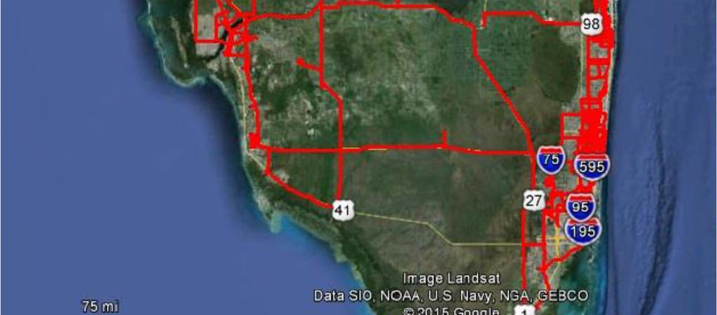
15 License Plate Data Matches Locations of license plate matched tanker trucks operating at Port Everglades 15
16 Findings Establish partnerships between agencies and with private sector Quantify petroleum product flows from PEV: Collect, or Approximate objectively Research and pilot test innovative technologies to: Identify and track Truck and Rail tanker vehicles Information sharing with freight community 16


17 Summary Data collection technology and approach pilot tested here tax revenue data and image recognition have potential for : Expanded national application for fuel and other tanker vehicles truck and rail Expansion to other vehicle and commodity types Rail corridor traffic makeup 17
18 Project Team FDOT Cambridge Systematics Gannett Fleming CTS Engineering Marlin Engineering Miovision 18
19 Project Info and Contacts Website: Contacts Min-Tang Li, FDOT District 4, Peter Haliburton, Cambridge Systematics, 19