AGENCY MEETING. I-10E Planning & Environmental Linkages Meeting #1 TxDOT Houston District
|
|
|
- Jordan Tate
- 5 years ago
- Views:
Transcription


1 AGENCY MEETING I-10E Planning & Environmental Linkages Meeting #1 TxDOT Houston District January 25, 2018


2 WELCOME TxDOT Project Manager: Grant Chim, P.E.
3 Agenda 1 Introductions / Purpose of Meeting 2 What is a PEL (Planning & Environmental Linkages) Study? Role of the Agencies Purpose of the PEL Study I-10E Study Limits Engagement Technical Process 8 Project Schedule and Next Steps 3
 Study?")


4 What is a Planning & Environmental Linkages (PEL) Study? An early planning study that links planning and the National Environmental Policy Act (NEPA) environmental studies. Initiates coordination with oversight agencies, stakeholders, and members of the public. Streamlines the overall project development process and minimizes duplication. 4
5 Role of the Agencies Goals & Objectives Inform Team Open Communication Review 5
6 Agencies Involved Agencies Federal, such as U.S. Army Corps of Engineers and U.S. Fish and Wildlife Service State, such as Texas Commission on Environmental Quality and Texas Parks and Wildlife Department Harris County Toll Road Authority Harris County Flood Control District Chambers-Liberty Counties Navigation District Railroads Emergency management: federal, state, and local 6


7 Agencies Involved Agencies Federal State Regional Local 7


8 Purpose of the PEL Study Explore improvements for a variety of transportation modes, such as highoccupancy vehicle lanes, truck lanes, transit, rail, bicycle, and pedestrian. The PEL process will identify projects for future implementation based on needs within the study area. 8

9 I-10E Study Limits 9

10 Engagement - Communications Tools Logo and branding Website and social media Fact sheets, project business cards Surveys Distribution at community centers and events 10


11 Engagement - Project Ambassadors Committee (PAC) Chambers County City of Baytown City of Houston Harris County METRO 11


12 Engagement - Stakeholder Groups Chambers of commerce, economic development councils, industry organizations, major employers Neighborhoods Social services Special interest, environmental 12

13 Engagement - Public Meetings Open house, interactive, encouraging feedback Four locations each round Houston Channelview Baytown Mont Belvieu Phase I Public Meeting: February

14 Technical Process Data Collection Previous Studies Environmental Constraints Traffic Data Port and Freight Traffic Accident and Crash Data Drainage Information 14
15 Corridor Segments 15
 System to system counts (34) Bluetooth data collection (73) Cell phone data")
16 Traffic Data Collection Mainlane volume counts (39) Intersection turning movement counts (66) 24-hour volume counts (365) System to system counts (34) Bluetooth data collection (73) Cell phone data collection 16
17 Data Collection Locations 17
18 Previous Studies 2003 The National I-10 Freight Corridor Study Summary of Findings, Strategies, and Solutions 2007 Houston Region Freight Study 2008 The National I-10 Freight Corridor Study Phase II Report / Corridor ITS Architecture 2010 H-GAC Subregional Planning Initiative East Port Transportation Land Use Vision Plan and Implementation Program 2011 H-GAC Fifth Ward Pedestrian Bicyclist Special District Study 2012 East End Mobility Study 2013 H-GAC Regional Good Movement Plan Baytown Mobility Plan 2014 Final Environmental Impact Statement The Grand Parkway Segments H and I-1 H-GAC Fifth Ward / Buffalo Bayou / East End Livable Centers Study 2016 H-GAC 2040 Regional Transportation Plan (RTP) I-10 Corridor Coalition A TPCB Peer Exchange H-GAC Kashmere Gardens Livable Centers Study Texas Freight Mobility Plan 2017 H-GAC Regional Transit Framework Study North Houston Highway Improvement Project Draft Environmental Impact Statement H-GAC State Highway 146 Subregional Study Houston Bike Plan 18


19 Additional Studies 2017 I-10 Western Connected Freight Corridor, Concept of Operations Study 19
 Parks / Recreation /")
20 Environmental Constraints Land Use Demographics Water Resources Biological Resources Hazardous Materials Neighborhood and Community Resources Cultural Resources (Historical & Archeological) Parks / Recreation / Conservation Areas 20
21 Identified Environmental Constraints Land Use / Demographics / Community Resources Fifth Ward Neighborhood environmental justice community; potential historic district Cultural Resources Sloan Memorial United Methodist Church historic church Evergreen Cemetery San Jacinto Funeral Home & Memorial Park Hazardous Materials San Jacinto Foundry Superfund site San Jacinto River Waste Pits Superfund site Parks Kress Lyons Park Hennessey Park Water Resources Hunting Bayou Greens Bayou Carpenters Bayou San Jacinto River Cedar Bayou 21

22 Existing Conditions Report Corridor Overview Physical Features Water and Drainage Features Utilities Transportation Facilities Traffic Data Safety Analysis Traffic Analysis & Operation 22

23 Roadway Network & Hurricane Evacuation Routes 23
24 Number of Lanes 24

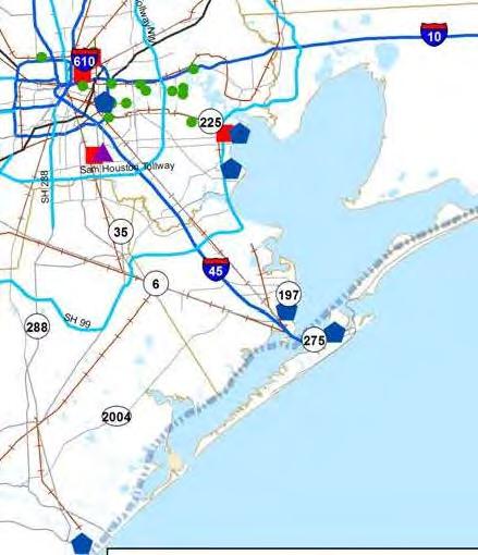
25 I-10E Typical Roadway Sections Number of Lanes Lane Widths Right of Way (ROW) Mainlanes (ML) Frontage Road (FR) Eastbound / West Bound (EB / WB) Study Limits 5 Segments 1: I-69 to east of I-610 2: East of I-610 to east of BW 8 3: East of BW 8 to Spur 330 4: Spur 330 to County Line 5: County Line to SH 99 25
26 I-10E Typical Roadway Sections Segments 1 & 2: I-69 to East of BW 8 26

27 I-10E Typical Roadway Sections Segments 3, 4, & 5: East of BW 8 to SH 99 27
28 Bridge Structures PEL Segment # Roadway Railroad Utility Pedestrian Utility / Pedestrian Total Total

29 Railroad Network 29
30 ITS Device Locations 30

31 Historical Flooding 31
32 Crash Frequency 32
33 2017 Truck Related Fatal Crashes* Date Location 6/25/2017 I-10E at Gellhorn 8/23/2017 I-10E at Dell Dale 4/4/2017 I-10E at Wade Rd 4/22/2017 I-10E at John Martin Truck related fatality *Not comprehensive list 33

34 Truck Volumes & Percent Trucks 34

35 Houston Area Ports 35
36 Freight Related Traffic 36

37 Projected Conditions Report Travel Demand Modeling H-GAC Subarea Model Cell phone data for Origin-Destination Future No-Build Years 2018 Existing 2025 Opening 2030 Interim 2040 Design 37
38 Existing Volumes 38

39 Levels of Service LOS A Free-flow operation LOS B Reasonably free flow Ability to maneuver is only slightly restricted Effects of minor incidents still easily absorbed From Highway Capacity Manual,


40 Levels of Service LOS C Speeds at or near FFS Freedom to maneuver is noticeably restricted Queues may form behind any significant blockage LOS D Speeds decline slightly with increasing flows Density increases more quickly Freedom to maneuver is more noticeably limited Minor incidents create queuing From Highway Capacity Manual,


41 Levels of Service LOS E Operation near or at capacity No usable gaps in the traffic stream Operations extremely volatile Any disruption causes queuing LOS F Breakdown in flow Queues form behind breakdown points Demand > capacity From Highway Capacity Manual,
42 AM Peak Hour Level of Service 42
43 PM Peak Hour Level of Service 43
44 Average Speed 7:00 AM to 9:00 AM 44
45 Average Speed 11:00 AM to 1:00 PM 45

46 Average Speed 4:00 PM to 6:00 PM 46
47 Travel Time AM 47
48 Travel Time Mid-Day 48

49 Travel Time PM 49
50 Level of Service vs. Travel Time Reliability Recurring variations in demand: 0% to 62% variation Severe weather (e.g., heavy rain, snow, poor visibility) Heavy rain: 16% reduction Very low visibility: 12% reduction Incidents (e.g., crashes, disabled vehicles, debris): up to 100% Work zones: 15% reduction in capacity for shoulder closed Special events: increase in demand 50

51 Project Schedule 51
52 Next Steps - Engineering Analyze No-Build Scenario Identify Issues & Concerns Develop Alternatives 52
53 Next Steps - Environmental Refine constraints map Qualify resources Quantify resources 53

54 Next Steps - Public Outreach Public Meeting #1 2/13: Mont Belview 2/15: Baytown 2/20: Channelview 2/22: Houston 54
55 THANK YOU! Contact: Grant Chim, P.E. (713)