Inland Waterway Navigation
|
|
|
- Georgina Bridges
- 5 years ago
- Views:
Transcription

1 Inland Waterway Navigation


; coal; sand and gravel")

2 Value of Inland Navigation As the sun rises over the Mississippi River a 15-barge tow slides slowly past the St. Louis Harbor and heads south to New Orleans where its cargo of grain will be transferred to a container ship for export overseas. The barge is one of many working the Mississippi and the nation s other great rivers on this day. Together these barges move more than 630 million tons of cargo over the nation s 25,000 miles of inland and intracoastal waterways each year. We are all dependent on the products petroleum (gasoline, crude oil, jet fuel); coal; sand and gravel used in construction; and grain being shipped on our nation s rivers. The U.S. Army Corps of Engineers is responsible for ensuring the safe, reliable, efficient and environmentally sustainable movement of vessels on more than half (about 12,000 miles) of the nation s inland and intracoastal waterway system. The Corps responsibilities include constructing and maintaining navigation channels and harbors and regulating water levels on inland waterways.


3 Value of Inland Navigation int he nation s inland and intracoastal waterway system carries nearly 1/6 of the cargo moved between cities the U.S. The Mississippi River and its tributaries and the Gulf Intracoastal Waterway connect Gulf Coast ports, such as Mobile, New Orleans, Baton Rouge, Houston, and Corpus Christi, with major inland ports, including Memphis, St. Louis, Chicago, Minneapolis, Cincinnati and Pittsburgh. The Mississippi River from Baton Rouge to the Gulf of Mexico allows ocean shipping to connect with the barge traffic, thereby making this segment vital to both the domestic and foreign trade of the United States. In the Pacific Northwest, the Columbia-Snake River System allows navigation 465 miles inland to Lewiston, Idaho. Barges are particularly well-suited for the movement of large quantities of bulk commodities, such as petroleum, coal, grain and raw materials at a relatively low cost. Coal is the largest commodity by volume moving on our inland waterways. America s utility industry depends on the nation s rivers for over 20 percent of the coal they consume to produce the electricity we depend on to run our homes, offices and industries. Overall, coal accounts for 50 percent of our nation s electricity production. About 22 percent of domestic petroleum is shipped by water. More than 60 percent of farm exports move on inland waterways such as the Lower Mississippi or Columbia rivers to downstream ports such as New Orleans for shipment overseas. Nearly 80 million tons of grain move by barge annually. Other major commodities including metal ores; stone, sand and gravel used in construction; chemicals including fertilizers; steel and cement; and many other products are also shipped by water. Inland Waterway Commodities SHARE BY TONS, 2006

 amounted to over 1 billion tons with a value of over $380 billion in 2007. These goods were shipped from 40 states.")
4 Value to the Economy Inland navigation is a key element of state and local government economic development and job creation efforts and is essential to maintaining our nation s economic competitiveness and national security. Inland and intracoastal waterways directly serve 38 states throughout the nation s heartland, the Atlantic seaboard, the Gulf Coast and the Pacific Northwest. The shippers and consumers in these states relied on the inland waterways to move over 622 million tons of cargo in All domestic waterborne commerce (inland, coastal and Great Lakes) amounted to over 1 billion tons with a value of over $380 billion in These goods were shipped from 40 states. Texas, Louisiana and Alaska each ship over $20 billion worth of cargo annually. Illinois, New York, California and Washington each ship between $10 and $20 billion yearly. Another eight states ship between $5 billion and $10 billion per year. It is $11 cheaper per ton to send these goods by water compared to other forms of transportation (such as trucks or trains), according to research by the Tennessee Valley Authority. That translates into nearly $7 billion in annual transportation savings for America s economy. Did you know that A single 15-barge tow can carry 26,250 tons of cargo or as much as 240 train cars or 1,050 tractor-trailer trucks? It would take an additional 6 million rail cars or 24 million trucks to transport the amount of cargo carried on inland waterways each year.


5 Value to the Environment The Corps carefully evaluates the environmental impact of each navigation project it undertakes. We typically perform computer modeling of planned changes to river and estuary systems to fully assess and limit the environmental effects of navigation projects before any work begins. Other ways that the Corps works to protect the environment when navigation projects are undertaken include: using dredge material as a resource for habitat and wetland creation, reducing disruption and damage to marine species by careful timing of dredging activities, and limiting environmental harm caused by dredging by using high-tech instruments to monitor dredge locations and activity. Another, less visible environmental benefit of the Corps navigation projects is that they help limit air pollution emissions by enabling tows with many barges to move cargo long distances on considerably less fuel than trains or trucks would need to move the same amount of cargo the same distance. The ability to move much more cargo per shipment by water than is possible by truck or train means that barge transport is both fuel-efficient and environmentally advantageous. On average, a gallon of fuel allows one ton of cargo to be shipped 155 miles by truck, 436 miles by rail and 576 miles by barge. America s inland waterways allow America to realize tremendous savings in fuel consumption and reduced air emissions from fuel combustion. How far one gallon of fuel moves one ton of freight, average by mode Truck Rail Barge MILES


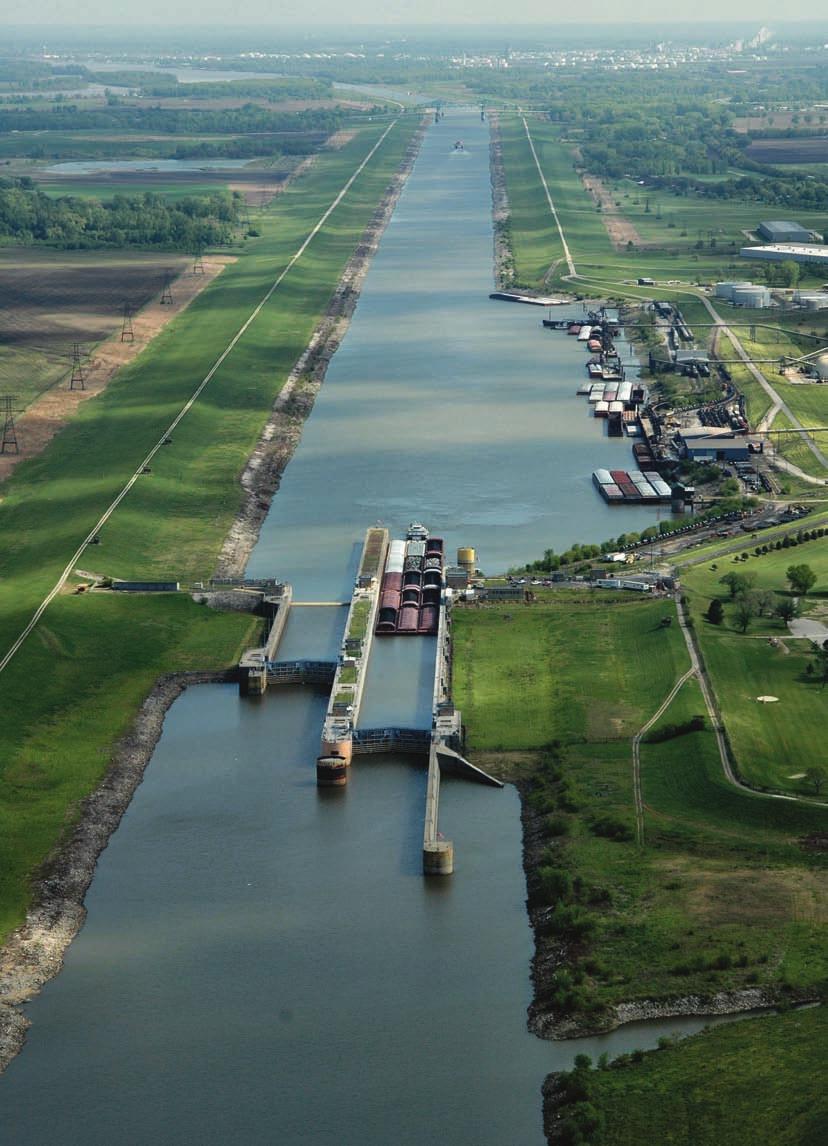
6 Tomorrow s Challenges TThe nearly 12,000 miles of U.S. inland and intracoastal waterways maintained by the Corps include 191 commercially active lock sites with 237 operable lock chambers. Some locks have more than one chamber, often of different dimensions. These locks provide the essential infrastructure that allows tows to stair-step their way through the system and reach distant inland ports such as Minneapolis, Chicago and Pittsburgh. The locks can generally be categorized into three different sizes, based on their length: 15 percent of the lock chambers are 1000 to 1200 feet long 60 percent are 600 to 999 feet long 25 percent are less than 600 feet long time consuming and cause long queues of tows waiting for their turn to move through the lock. Over 50 percent of the locks and dams operated by the Corps are over 50 years old. Many of the 600-foot locks on the system were built in the 1930s or earlier, including those on the heavily-used Ohio, Upper Mississippi, Illinois and Tennessee rivers. These projects are approaching the end of their design lives and are in need of modernization or major rehabilitation. The consequences of this aging infrastructure The 1200-foot locks can accommodate a tow of 17 barges plus the towboat, while the 600-foot locks can accommodate at most eight barges plus the towboat. The lock size and tow size are critical factors in the amount of cargo that can pass through a lock in a given period of time. Since many of today s tows operate with 12 or more barges, passing through a 600-foot lock requires the tow to be cut into two sections to pass the lock. Such multiple cuts can be are increasing incidents of downtime and a higher risk of major component failures. Modernizing the Locks In the 1960s the Corps began to modernize the locks on the Ohio River and add 1200-foot chambers that permit a typical tow to pass in a single lockage. This modernization process continues today with the construction of a new dam with twin 1200-foot locks at Olmsted located at the confluence of the Ohio and Mississippi rivers and 1200-foot chambers at the McAlpine and John T. Myers Locks and Dams also on the Ohio. In addition, modern 1200-foot chambers are being constructed at Kentucky Lock on the Tennessee River and at Inner Harbor Lock on the Gulf Intracoastal Waterway at New Orleans. Other projects are underway in Pennsylvania, West Virginia, and Arkansas. In addition, several major rehabilitations of existing locks are underway.


7 Tomorrow s Challenges studies will identify the navigation and environmental actions needed to support the inland waterway system of the future. Annual capital spending for the inland waterway system has increased from less than $200 million in recent years to nearly $650 million for 2009 (including funds provided by the American Recovery and Reinvestment Act of 2009). This will help accelerate completion dates for ongoing lock modernization. Domestic freight traffic is expected to increase by 67 percent in coming years. More of this freight could be moved by barge with economic and environmental benefits if our navigation system is deemed reliable. It has been estimated that postponing waterway modernization projects has already cost the Nation in excess of $7 billion in lost economic value. Timely completion of current inland navigation projects and justified future navigation improvements would allow America to meet the transportation challenges of the 21st Century while protecting and enhancing our Nation s treasured river heritage. Altogether this ongoing work represents an investment of over $3.5 billion in inland waterway modernization that will be completed over the next decade. Half of this investment comes from fuel taxes paid by the inland towing industry. These rehabilitation projects include not only the development of modern navigation facilities, but also important investments in environmental restoration and management. Several key navigation improvement projects are authorized or under study throughout the inland waterway system, including on the Upper Mississippi River and Illinois Waterway, Ohio River, the Gulf Intracoastal Waterway, and the McClellan-Kerr Arkansas River Navigation System. These
, the Department of Homeland Security (DHS) and the Department of Commerce (DOC). The DHS, through the U.S. Coast Guard, has responsibility for vessel and navigation safety and provides navigation aids and search and rescue services.")

8 Working Together In carrying out its inland navigation responsibilities, the Corps works closely with a variety of Federal agencies including most prominently the U.S. Department of Transportation (DOT), the Department of Homeland Security (DHS) and the Department of Commerce (DOC). The DHS, through the U.S. Coast Guard, has responsibility for vessel and navigation safety and provides navigation aids and search and rescue services. The DOT s Maritime Administration supports the development of U.S. ports, intermodal systems and domestic shipping, while Learning More: To learn more about the nation s inland and intracoastal waterways and the Corps role in maintaining them, please visit DOT s St. Lawrence Seaway Development Corporation supports the operation of that waterway in partnership with Canadian authorities. DOC s National Oceanic and Atmospheric Administration provides surveys, tidal information and coastal charts. The Corps also partners with state and local governments, port authorities, and many private environmental groups and trade organizations to solve problems and take advantage of water resource development opportunities that are in the national interest. We look forward to expanding these partnerships and building new alliances as we work to meet the challenges and opportunities facing our nation s ports and harbors in the years ahead Produced by the U.S. Army Engineer Institute for Water Resources in partnership with the Headquarters. To inquire about this brochure, please contact the IWR publications office at CEIWR.Publications@usace.army.mil. For the sources of information used in this brochure, visit