Appendix C Scoping Meeting Materials
|
|
|
- Anastasia Dorsey
- 5 years ago
- Views:
Transcription
1 Appendix C Scoping Meeting Materials
2 Appendix C - Contents Sign-in Sheet for Agency Scoping Meeting Sign-in Sheet for Public Scoping Meeting Scoping Information Booklet Scoping Presentation Scoping Brochure/Comment Form
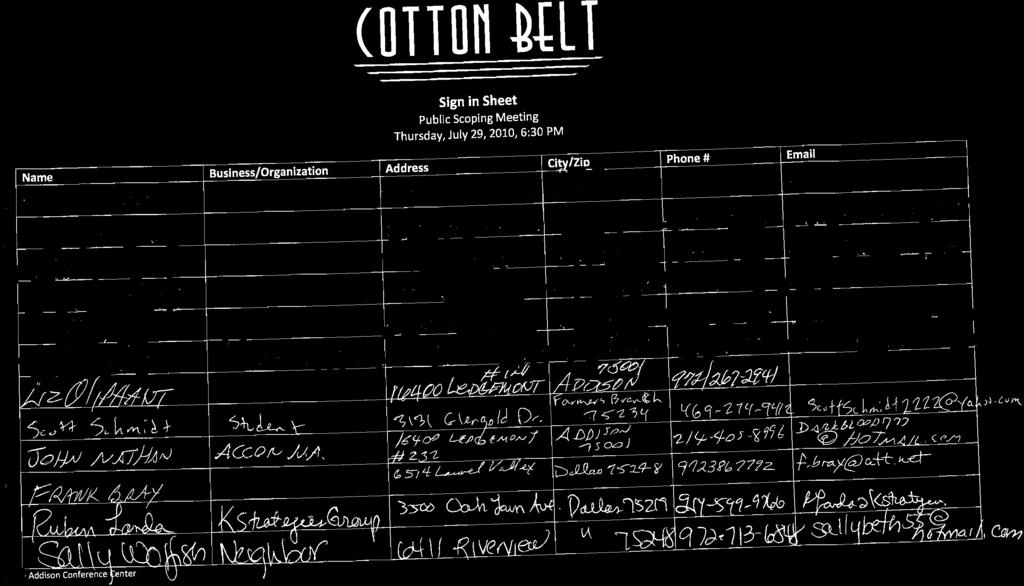
3 Sign-in Sheet for Agency Scoping Meeting
4
5
6
7
8 Sign-in Sheet for Public Scoping Meeting

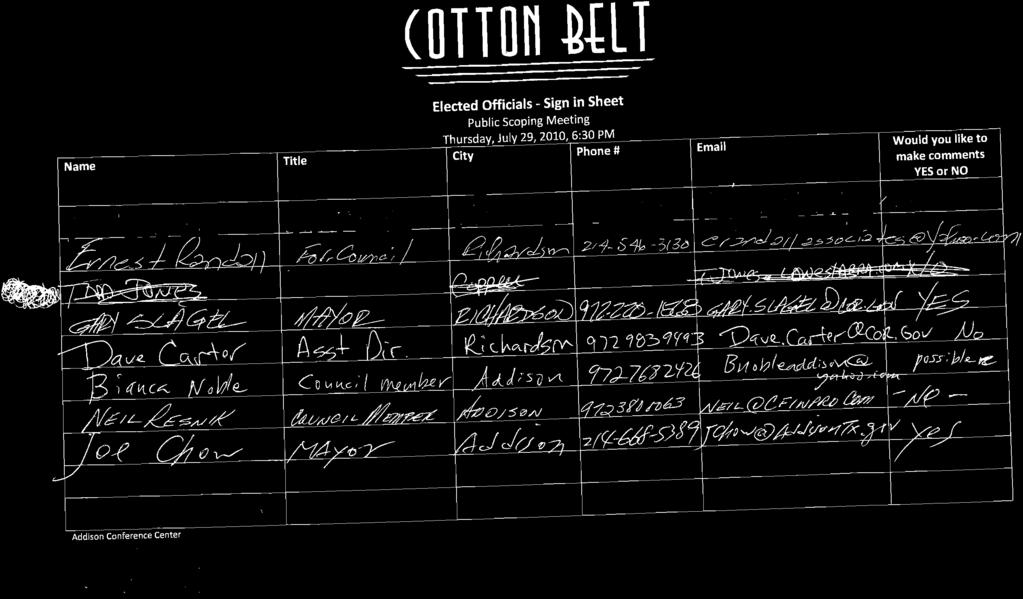
9
10
11
12
13
14
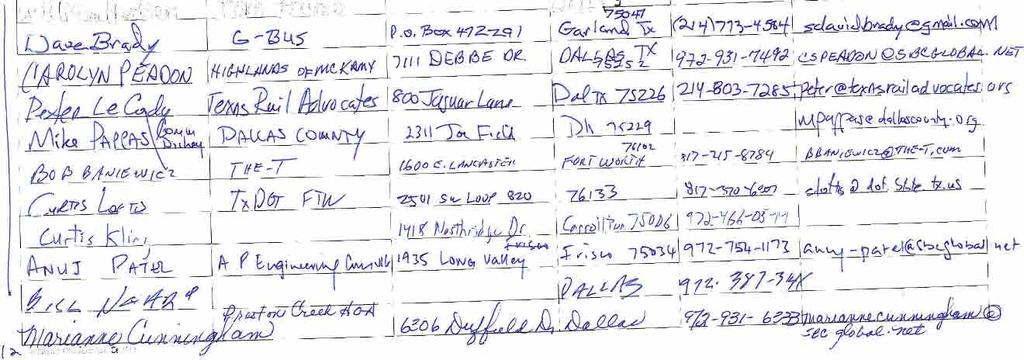
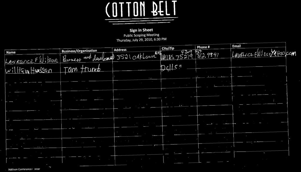
15
16
17
18
19
20 Scoping Information Booklet
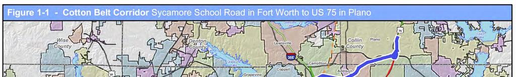
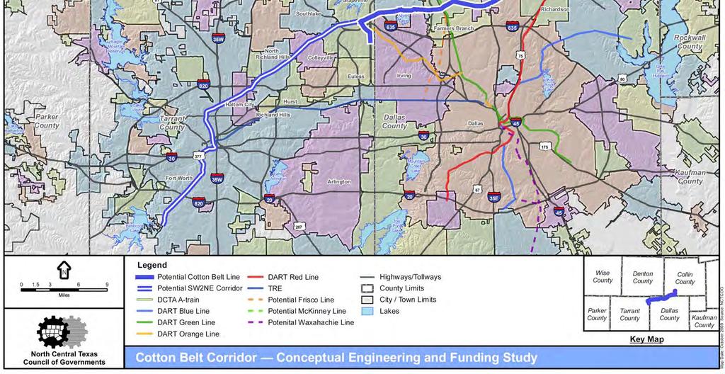
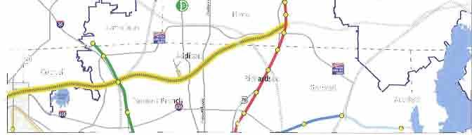
21 LEGEND COTTON BELT CORRIDOR (DFW AIRPORT TO RED LINE) Grapevine DCTA A-Train Proposed SW2NE Rail Corridor by The T LAKE LEWISVILLE 35 E Coppell NORTH LAKE 635 Carrollton Dallas Addison Farmers Branch 635 Preston Road Preston Road Plano Richardson DART RAIL BLUE LINE RED LINE GREEN LINE (OPENS DEC 2010) FUTURE ORANGE LINE FUTURE BLUE LINE SERVICE AREA BOUNDARY OTHER RAIL DCTA A-TRAIN SW2NE RAIL CORRIDOR RAILROAD CORRIDORS Garland Rowle About the Project The Cotton Belt Corridor Regional Rail Project proposes a new regional rail line within the 26-mile Cotton Belt Corridor between Dallas-Fort Worth International Airport (DFW Airport) and the existing Dallas Area Rapid Transit (DART) Red Line Light Rail Transit (LRT) corridor in the Richardson/Plano area. The Cotton Belt Corridor traverses Tarrant, Dallas and Collin Counties, and includes the communities of Grapevine, Coppell, Carrollton, Addison, Dallas, Richardson, and Plano, as well as portions of DFW Airport. The proposed project would lie within right-of-way purchased by DART in 1990 and designated as a preserved corridor for future regional rail service. The corridor has been included in various DART and North Central Texas Council of Governments (NCTCOG) planning documents since 1983 as an alignment alternative for regional rail. The base corridor includes numerous roadway crossings including major roadway facilities such as State Highway (SH) 121, Interstate Highway (IH) 635, the President George Bush Turnpike, IH 35E, the Dallas North Tollway (DNT) and US 75 (North Central Expressway). It is anticipated the Cotton Belt Corridor Regional Rail Project would interface with six other major regional rail lines, including This booklet is designed to help you participate in the scoping process for the Cotton Belt Corridor Regional Rail Project. Within this booklet you will find descriptions of the alternatives currently under consideration and important background information about the project. 1

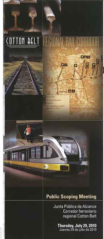
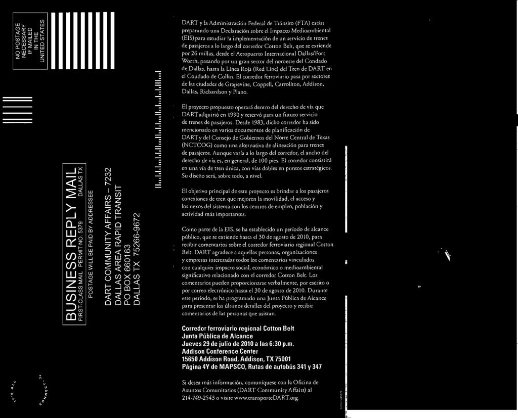
22 PUBLIC SCOPING MEETING July 29, :30 p.m. Addison Conference Centre Addison Road Addison, TX date/time Thursday July 29, :30 p.m. LOCaTION Addison Conference Centre Addison Road Addison, Texas Meeting locations are accessible by transit. Visit DART s website at to plan your trip. Please notify the DART Community Affairs representative at (214) at least one week in advance of the meeting date if language translation or hearing-impaired signing is needed. The building used for the scoping meeting is accessible by persons with disabilities. PrIvaCY NOTICE Your privacy is important to us. Your contact information will be used for the sole purpose of this project and will not be sold, shared, distributed or used for any other purpose. However, we wish to inform you that all comments received during Scoping will be part of the public record. YOU are INvITEd TO attend ThE PUBLIC SCOPING MEETING The Public Scoping Meeting will offer an opportunity to discuss project-related issues with project staff and view displays to help you understand the proposed project options. The meeting will include a brief presentation that will focus on the scoping process, project purpose and need, and alternatives currently under consideration. After the presentation, you will have an opportunity to comment on the purpose of and need for the project, alternatives to be evaluated, and potential environmental issues and benefits of the proposed project. The scoping information is also available on the project web site at A separate Interagency Scoping Meeting will be held to receive input from federal, state, tribal, regional and local government agencies that may have an interest in the project. For more information see contact information below. Get involved early in the process and contribute your ideas. Your input, whether oral or written, will help shape your community s quality of life. Oral comments can be made at the scoping meeting a court reporter will be documenting the meeting. Written comments can be given at the scoping meeting, mailed, or made on the project web site. Written comments should be sent by the close of the scoping comment period on August 30, 2010, to Mr. John Hoppie at the address provided below. FOr MOrE INFOrMaTION Mr. John Hoppie, Project Manager Dallas Area Rapid Transit P.O. Box Dallas, TX Telephone: (214) Fax: (214) jhoppie@dart.org
23 DART s Orange, Green and Red LRT lines, a proposed BNSF Corridor service that would interface with the Cotton Belt in downtown Carrollton, a proposed extension of the Denton County Transportation Authority (DCTA) A-Train service to downtown Carrollton, and the planned Southwest to Northeast (SW2NE) rail corridor connection at DFW Airport by the Fort Worth Transportation Authority (The T). BACKGROUND The DART 2030 Transit System Plan (TSP) identifies the Cotton Belt Corridor as a priority project with implementation in the year timeframe. Given the regional desire to accelerate the segment from DFW Airport to the DART Red Line, Mobility 2030: The Metropolitan Transportation Plan for the Dallas- Fort Worth Area identifies this project, and possibly portions of the SW2NE project, as a candidate for a public-private partnership (PPP) to design, build, operate, maintain and/or finance the corridor. DART initiated the PPP effort in May 2009 with a Request for Information (RFI). On May 11, 2010 the DART Board of Directors authorized the President/Executive Director to execute the Memorandum of Understanding between DART and the Regional Transportation Council (RTC) concerning the identification of funding sources to implement regional rail service on the Cotton Belt Corridor. As a result, the RTC/NCTCOG issued a Request for Proposals entitled Cotton Belt Passenger Rail Corridor Innovative Finance Initiative (Planning Services). Based on early input during the DART PPP RFI, potential private partners noted that a more detailed project definition and environmental clearance would be needed before advancing the project. As a result, DART is advancing preliminary engineering and conducting an Environmental Impact Statement (EIS), which includes identification of environmental impacts, design considerations and cost estimates to inform the innovative finance effort. PURPOSE OF AND NEED FOR THE PROJECT The primary purpose for the proposed Cotton Belt Corridor Regional Rail Project is to provide regional rail connections that will improve mobility, accessibility and system linkages to major employment, population and activity centers in the northern part of the DART Service Area. The connection of three LRT lines and two planned regional rail lines (DCTA A-Train and The T s SW2NE Project) makes regional connectivity a key component of the Cotton Belt Corridor. The Cotton Belt Corridor also offers opportunities to connect with the proposed BNSF regional rail corridor between Frisco and Irving, with a connection in downtown Carrollton. GOALS AND OBJECTIVES Enhance corridor mobility and accessibility cc Provide connectivity to existing and planned regional rail facilities cc Provide transportation investments serving future population and employment growth cc Improve access to existing and emerging major activity centers cc Increase transit usage for existing and new riders cc Improve access to transit cc Provide cost-effective options Reduce congestion cc Increase transit capacity and improve travel times through more reliable transit cc Improve air quality cc Reduce demand on local roadways cc Reduce number of single occupant vehicles Encourage economic development cc Encourage employment opportunities cc Encourage economic development opportunities cc Encourage sustainable and livable development opportunities cc Encourage consistency with regional and local transportation and comprehensive plans cc Encourage strategies for land use development and redevelopment Provide an environmentally-sensitive transit investment cc Minimize negative impacts to the community cc Minimize negative impacts to the environment cc Minimize negative impacts to natural, social and economic environments 3

24 Addison Transit Center The Addison Transit Center is currently a major bus interface location and park-and-ride facility. It is located adjacent to the Cotton Belt Corridor and could become a rail station. Regional demand for travel in the study area is projected to increase along with congestion. Implementation of regional rail service would improve transit performance in the study area by offering a new, more reliable service. By providing a new transportation option, peak period congestion would be reduced, providing improvements to regional air quality. THE SCOPING PROCESS What is Scoping? The first step in the project development process is to involve the community in outlining the scope of the project. The scoping process ensures that citizens, elected officials, and appropriate government review agencies are involved early in the decision-making process and in outlining the scope of the study so comments and concerns can be addressed during the project development phase. Throughout the scoping process, you will have an opportunity to review information and offer your comments either orally at the upcoming public scoping meeting or in writing. Why is Scoping Important? The purpose of scoping is to inform the public that the environmental review process is beginning. In addition to initiating dialogue on the proposed alternatives, scoping is instrumental in identifying issues to be considered and/or resolved during the project development process. At the scoping meeting, the project team will explain the scoping process and environmental review process, describe the alternatives currently being considered, and ask for your ideas and comments. You are invited to comment on the alternatives to be addressed; the alignments and station locations to be considered; and the environmental, social, and economic concerns to be analyzed. Interested individuals, organizations, or agencies may propose the consideration of additional, specific alternatives or the study of a specific potential environmental effect associated with an alternative. What is the Outcome of Scoping? At the conclusion of the scoping comment period, comments received will be considered by DART to make The region is a non-attainment area for air quality. Mobile source emissions from vehicles must be addressed with multi-modal transportation solutions, such as those being considered in the Cotton Belt Corridor Regional Rail Project. The Cotton Belt Corridor project is a major step to advance the implementation of regional rail improvements to address existing, as well as projected congestion, and to improve air quality, or at least to not degrade it any further. 4
25 project decisions that are in the best overall public interest. A Scoping Summary Report will be prepared and it will contain comments received during the comment period, describe the content of the meetings, and document the process by which the alternatives were refined. The Final Scoping Summary Report will be published on the project web site. Following project scoping, preliminary engineering will begin, which will include developing a design for how the project will look and operate and where stations will be located within the corridor. ENVIRONMENTAL REVIEW PROCESS The Cotton Belt Corridor Regional Rail Project is being evaluated by a process set forth by the Federal Transit Administration (FTA) in accordance The NEPA process is intended to help public officials make decisions that are based on understanding of environmental consequences, and take actions that protect, restore, and enhance the environment. National Environmental Policy Act with the National Environmental Policy Act (NEPA) of 1969, as well as provisions of the enacted Safe, Accountable, Flexible, Efficient Transportation Equity Act: A Legacy for Users (SAFETEA-LU). Compliance with NEPA and SAFETEA-LU s implementing regulations is necessary for a project to be eligible for federal capital funds. DART is complying with all federal, state and local regulations regarding the evaluation of alternatives to provide needed transit services within the study area. The EIS process allows for careful consideration of the design, costs, and benefits of transportation alternatives and will document probable effects and potentially significant impacts to social, economic and environmental factors associated with the proposed alternatives. Preliminary engineering will define physical and operational aspects of the proposed project in sufficient detail to assess environmental effects. The proposed project may generate environmental benefits, so the EIS will document positive impacts as well. A Draft EIS will be available for public and agency review and comment and a public hearing will be held. Following the comment period on the Draft Cotton Belt Corridor Regional Rail Project EIS Process and Schedule WE ARE HERE Notice of Intent Public Scoping Process Scoping Meetings and Comment Period Draft Preliminary Engineering and Draft EIS Preparation Draft EIS Distributed Public Hearing and 45-Day Comment Period Final EIS Preparation Final EIS Distributed 30-Day Comment Period Anticipated Record of Decision JUL 2010 JUL / AUG 2010 AUG 2010 to JUN 2011 JUL 2011 AUG / SEP 2011 OCT 2011 DEC

26 EIS, a Final EIS will be prepared that will respond to comments received during the circulation of the Draft EIS, identify additional analyses that will be required to adequately respond to public comment or resolve issues in the Draft EIS, and identify mitigation measures and develop a mitigation monitoring program. The FTA and DART announced the decision to prepare an EIS for the proposed project with a Notice of Intent that was published in the Federal Register on July 8, Once the preferred alternative is selected as a result of the EIS process, it is anticipated that the FTA will proceed to the Record of Decision (ROD) after which funding negotiations with FTA or other partners will advance. The ROD must be issued prior to entering into the Final Design phase of the project if a Build Alternative is selected. ALTERNATIVES CURRENTLY BEING CONSIDERED Alternatives to be reviewed in the EIS include a No-Build Alternative and the Build Alternative, which may include design options and various station locations. No-Build Alternative The inclusion and analysis of the No-Build Alternative is required in the EIS process. The No-Build Alternative is included as a benchmark INTERMODAL CONNECTIVITY A feasibility study was recently completed to modify the existing Red Line bridge over the Cotton Belt (foreground) to accommodate a potential new Red Line station. This is one of several options to be further evaluated during preliminary engineering. against which the impacts of other alternatives can be compared. For this study, the No-Build Alternative assumes a 2030 condition of land use and demographics. It includes transit capital and service improvements that are programmed to be implemented by DART and other transit providers in the study area, as well as all other planned, programmed, and funded transportation projects for the planning year Regardless of whether or not the Cotton Belt Corridor Regional Rail Project is implemented, the projects associated with the No-Build Alternative would be funded and built. Build Alternative The Build Alternative would consist of regional rail service within the Cotton Belt Corridor and it is anticipated that the vehicle type would comply with the requirements of the Federal Railroad Administration (FRA) safety A note about the SW2NE project.the T completed a Draft EIS for the SW2NE project in October 2008 and the Final EIS is expected to be complete in The SW2NE project is anticipated to receive environmental clearance for the section of the Cotton Belt Corridor from north of DFW Airport to Fort Worth and for a new rail corridor extending from the Cotton Belt Corridor south into DFW Airport Terminal B. 6
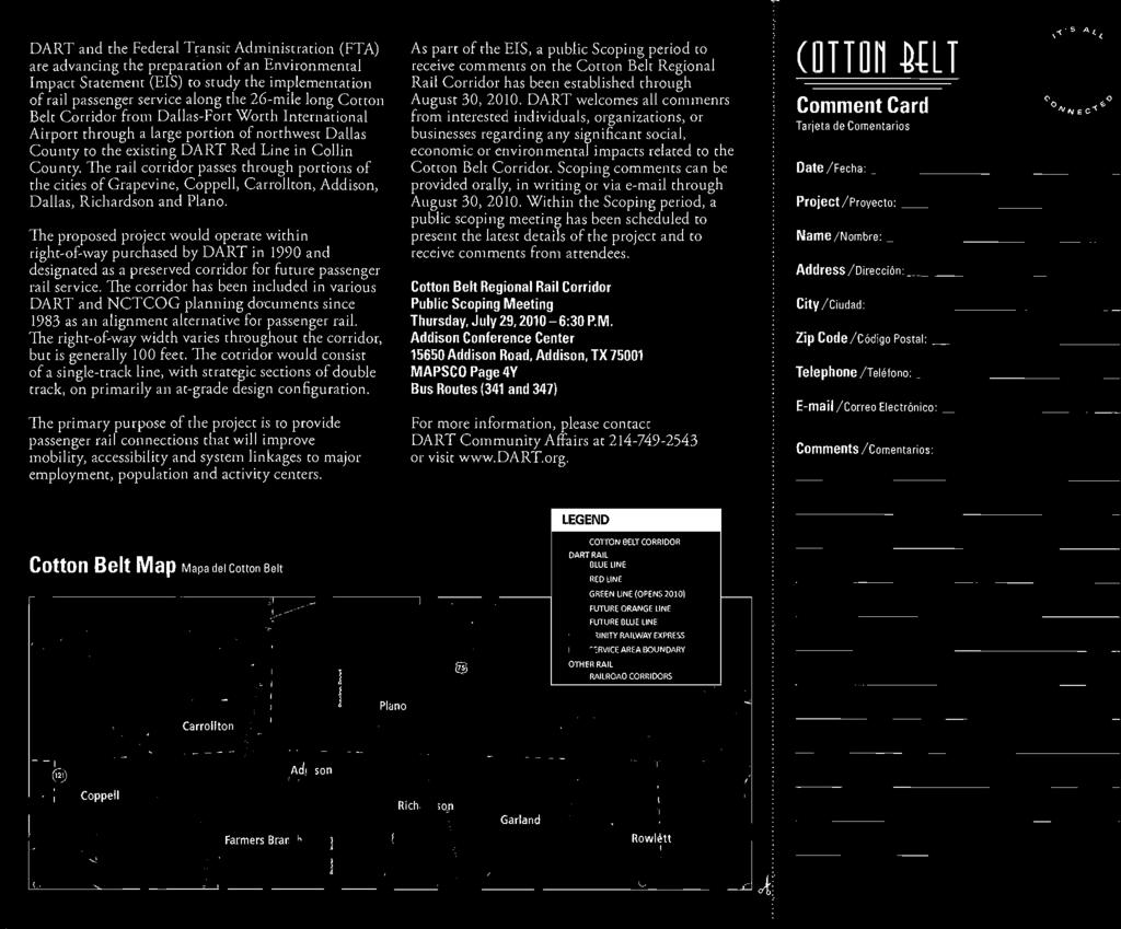
27 standards (FRA-compliant vehicle). Service would be provided every 20 minutes during the peak periods and every 60 minutes during the off-peak period. A base alignment and potential station locations will be examined along with various options for the eastern terminus, stations, passing siding/double-track locations, and possible horizontal and vertical alignment deviations at strategic locations. At its western terminus, the proposed project would interface with DART s future Orange Line LRT service, which will extend from DFW Airport through Irving to downtown Dallas, and with The T s planned SW2NE regional rail corridor service from southwest Fort Worth to DFW Airport. At the eastern terminus, the base corridor assumes an interface with the existing DART Red Line at the intersection of the two corridors, which would require a new LRT station at the location. Additional options for the Cotton Belt Corridor eastern terminus include: turning south to connect to the existing DART Red Line Bush Turnpike Station, turning north to connect to the existing Red Line Downtown Plano Station (which may allow an option for service to continue farther north into Plano or McKinney), or extending farther east on the Cotton Belt line to terminate near Shiloh Road in Plano. Several new rail stations would be provided, depending upon the build alternative selected. Station platforms would be approximately 300 to The Cotton Belt Corridor project team encourages you to keep expressing your concerns, offering suggestions, and asking questions during Scoping and throughout the project development process. Your concerns about the environment and community will guide us in designing regional rail improvements that will best respond to the transportation problems and concerns of your community and the region. 500 feet in length. Potential station locations include: DFW Airport, North Lake, Downtown Carrollton (Green Line interface), Addison (existing Transit Center), Knoll Trail, Preston Road (State Highway 289), Renner Village, UTD Synergy Park, the Red Line Interface, and Shiloh Road. Additional alternatives that emerge during scoping that reasonably address the project s purpose and need and that have not been previously evaluated will be considered. MORE OPPORTUNITIES FOR INVOLVEMENT This is just the beginning! The scoping meeting is just one of many opportunities that you will have to provide comments, gather information, and make inquiries about the Cotton Belt Corridor Regional Rail Project. Public comments, suggestions, and requests for information are recorded and distributed to project team members. We want you to help our team design a system that meets your needs. Your comments are encouraged and will be considered throughout the Cotton Belt Corridor Regional Rail Project. For Additional Information, Documents and Upcoming Events Visit DART s website at DART.org/cottonbelt for additional project information including key Cotton Belt Corridor Regional Rail Project information, documents and upcoming events. The Scoping comment period for the Cotton Belt Corridor Regional Rail Project will close on Monday, August 30,
28 Public Meeting Thursday, July 29, :30 p.m. Addison Conference Centre Addison Road Dallas, Texas Keller Springs Rd. ADDISON AIRPORT Quorum Dr. Midway Rd. COTTON BELT CORRIDOR Addison Rd. Julian St. Addison Circle Lindberg Dr. TC ADDISON TRANSIT CENTER Arapaho Rd.
29 Scoping Presentation
30 1

31 Scoping Meetings July 28, 2010 Agency Scoping July 29, 2010 Public Scoping 2
32 Agenda Introductions Scoping Project History and Community Issues Project Development Process Project Overview Public Involvement Comments 3
33 4
34 Why is transit important to the region? 4th Largest Metropolitan Area in the United States Ranked first for Population Growth among U.S. Metropolitan Areas during 2009 Represents Over 34 Percent of the State s Economy 6.5 Million Persons in Year 2009 Growing to 10 Million Persons by the Year 2035 Air quality and traffic will worsen Dallas-Fort Worth Metropolitan Area 5

35 Scoping Purpose of Scoping: To involve community in outlining the scope of the project To ensure that citizens, elected officials, and government agencies are involved in the decision-making process To provide an opportunity to voice comments and concerns during the planning of a project 6
36 Federal NEPA Process WE ARE HERE Notice Notice of of Intent Intent Published July 8, 2010 Published July 8, 2010 in Federal Register in Federal Register Scoping Preliminary Preliminary Engineering/EIS Engineering/EIS Draft Draft EIS EIS Distribution 30-day Public Public Comment Final Final EIS EIS Distribution Final Final EIS EIS Preparation 45-day Public Public Comment Record of of Decision* *FTA will not issue a ROD until funding of the project is well defined 7
37 Agency Coordination Lead Agencies DART and Federal Transit Administration (FTA) Invited to be Cooperating Agencies Federal Aviation Administration (FAA), Federal Railroad Administration (FRA) Participating Agencies Local, state and federal agencies Regional Partners The T, NCTCOG, Airports, DCTA, NTTA, TxDOT SAFETEA-LU Coordination Plan To enable more efficient and effective reviews of the environmental review process 8
38 Stakeholder Coordination Property Owners Neighborhood Associations Freight Rail Companies DGNO, BNSF, KCS, FWWR and UP Chambers of Commerce/business community Developers Schools and Universities Utilities Other interest groups 9
39 The Cotton Belt Corridor Regional Rail Project 10
40 Cotton Belt Corridor History April 1983 Oct Nov Dec Jan May 2001 Jan April 2005 Oct June 2007 April 2009 April 2010 DART Final Service Plan Corridor was purchased by DART DART Transit System Plan Mobility 2020 The Metropolitan Transportation Plan Mobility 2025 The Metropolitan Transportation Plan Mobility 2025 Update The Metropolitan Transportation Plan Mobility 2025 The Metropolitan Transportation Plan 2004 Update Mobility 2025 The Metropolitan Transportation Plan April 2005 Amendment DART 2030 Transit System Plan Mobility 2030 The Metropolitan Transportation Plan Mobility 2030 The Metropolitan Transportation Plan 2009 Amendment Cotton Belt Corridor Conceptual Engineering and Funding Study 11

41 Revenue Service Projected:
42 Key Community Issues Noise and Vibration Traffic and Safety Visual Air Quality Natural Resources Vegetation Water Resources Property Values Comments received have influenced efforts to date 13

43 Corridor Development Conditions DART Board Resolution to guide planning efforts in corridor: Pursue removal of freight Impacts mitigated to a level consistent with DART light rail. DART acknowledges City of Dallas preference for trench option. Locomotive-hauled passenger rail will not be considered Size of rail car generally consistent with DART light rail vehicle Emissions will meet or beat Environmental Protection Agency (EPA) standards City of Dallas preference for stations at Knoll Trail, Preston Road, and west of Coit Road City of Dallas preference to minimize number of tracks 14
44 The Cotton Belt Corridor Freight Abandonment DART requested formal freight abandonment on portion of the Cotton Belt. STB approved request effective January 27,
 Service Frequency 20-minute peak service 60-minute off-peak service")
45 Regional Rail New Technology New concept vehicle Characteristics similar to DART Light Rail Will be Federal Railroad Administration (FRA) Compliant Environmentally and community-friendly Self propelled (No locomotive haul rail) Service Frequency 20-minute peak service 60-minute off-peak service 16
46 Why Now? Regional desire to advance corridor Plano, Richardson, Dallas, Addison, Carrollton Regional Transportation Council Improved connectivity with DART radial corridors Red Line, Green Line, Orange Line Opportunity for regional connections The T (SW2NE), DCTA (The A-Train) 17


47 The T: SW2NE DCTA: A-Train 18

48 Conceptual Engineering and Funding Study Completed by the NCTCOG in April 2010 Identified design options and potential station locations Provided foundation for further environmental study Key element to identify funding sources 19
49 Financial Study May 2010, DART and The T authorized Memorandum of Understanding (MOU) with Regional Transportation Council (RTC) to pursue funding RTC/NCTCOG leading an innovative funding initiative concurrent with PE/EIS effort DART PE/EIS will coordinate with and inform the innovative funding initiative Funding Plan required to move project forward 20
50 Project Development Process Regional Regional Transportation Plan Plan DART DART Transit Transit System System Plan Plan NCTCOG NCTCOG CE&FS CE&FS PE/EIS PE/EIS Scoping Record of Decision Public Involvement Design/ Construction Operation 21
51 Scoping We want your input on: Draft Purpose and Need Key issues, impacts, or concerns that should be addressed Alternatives or design options to be considered Alignments and Station Locations Operations Maintenance Facility Location 22
52 Draft Purpose and Need To improve mobility, accessibility in the corridor To provide system linkages to major employment, population and activity centers in the northern part of the DART Service Area To maintain regional competitiveness To enhance quality of life To provide opportunity for economic development 23
53 Environmental Analysis Categories Land use and socioeconomic conditions Zoning Community services and resources Environmental justice Acquisitions/displacements and relocations Soils and geology Ecosystems Wildlife Water resources (water quality, wetlands, surface water, groundwater, floodplains) Noise and vibration Habitats Vegetation Electromagnetic radiation Air quality Hazardous and regulated materials Historic, archeological, and cultural resources Public parklands Traffic and transportation Visual and aesthetic resources Safety and security 24
54 Initial Alternatives No Build (No Action) Primarily At-Grade (Below Grade in North Dallas) Primarily At-Grade (Grade Determined by NEPA Process) North Dallas NEPA requires evaluation of all feasible and prudent alternatives 25

55 Key Issue Areas Western terminus North Lake Downtown Carrollton Green Line interface North Dallas Trench Option Eastern terminus and Red Line interface 26

56 Eastern Terminus Options * * * 27

57 Potential Station Locations 28 28
58 PE/EIS Project Schedule * *FTA will not issue a ROD until funding of the project is well defined 29
59 How to Stay Informed Public Meetings Public Hearings Newsletters Quarterly Website Project Information Project Documents Newsletters 30
60 Scoping Comments and Input Make a public comment (oral or written) Close of Scoping period: August 30, 2010 Comments will be documented in the Scoping Summary Report and made available to the public on the project website 31
61 Ways to Comment - Written Complete a comment sheet Send comments through project website: Send written comments to DART COMMUNITY AFFAIRS Dallas Area Rapid Transit P.O. Box Dallas, TX
62 Ways to Comment - Oral We Want to Listen to Everyone Your statement recorded today by a court reporter Please fill out a request to speak card Please say your full name before your statement Your statement up to 3 minutes 33

63 34
64 Scoping Brochure/Comment Form
65
66