Automating Your Monitoring with the Latest suas Technology. Harry White, Forest Ecologist, Colebrook, CT
|
|
|
- Jesse Bennett
- 5 years ago
- Views:
Transcription


1 Automating Your Monitoring with the Latest suas Technology Harry White, Forest Ecologist, Colebrook, CT
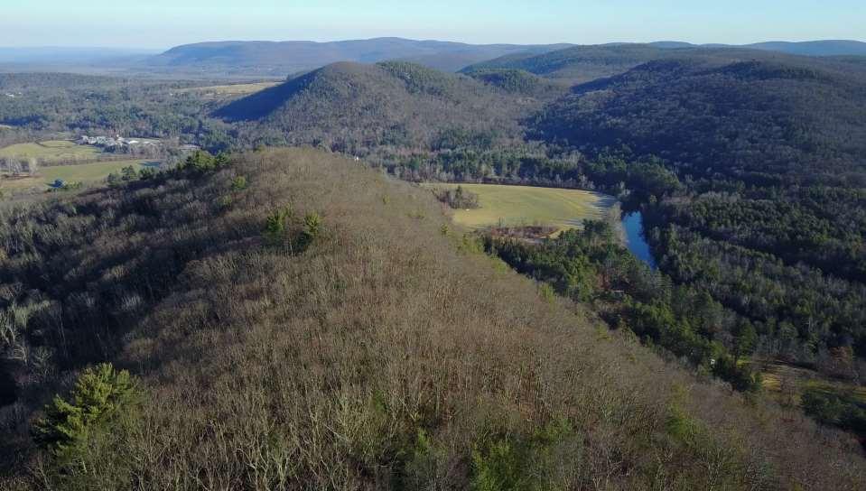
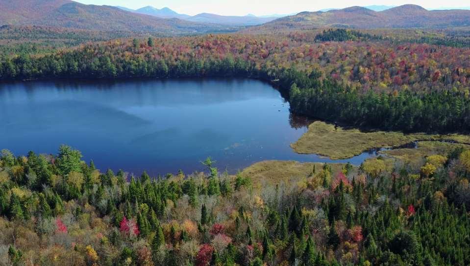
2 Primary Uses: Annual Property Monitoring Easement and Fee Inspections Big-Block Challenges Stewardship Work Agriculture Wetlands/Rivers Forest Cover Building Envelope Development External Threat Monitoring Ecological Monitoring Invasive Species Imaging the Landscape Understanding Landscape Scale and Context PR Products Mapping Advanced Scientific Applications

3
4

5

6

7

8

9

10

11
12

13

14

15

16

17

18


19 Introduction to UAS and Basic Data Outputs
20 What are Unmanned Aerial Systems? UAS, UAV, Drone, MultiCopters, Fixed Wing suas: Remotely piloted aircraft < 55 pounds (FAA) Similar to traditional remote sensing suas niche: Smaller areas Higher resolution On-demand Affordable


21 Flavors of suas Multicopters Versatile Operate in difficult terrain Shorter flight times Fixed Wing Mapping specialization Long endurance Landing space Commonalities Battery powered GPS Ground control station Sensor payloads

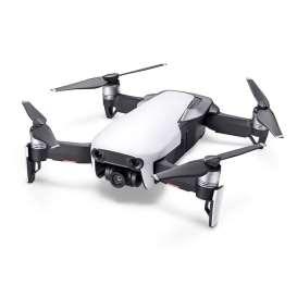

22 Examples - Multirotors DJI Inspire DJI Mavic Pro DJI Mavic Air
23 DJI Aircraft Comparisons Mavic Pro Mavic Air Inspire 1v2 Inspire 2 Flight Time 27 min 20 min 22 min 27 min Top Speed 40 MPH 42 MPH 58 MPH 58 MPH Range 4.3 miles 2.4 miles 4.3 miles 4.3 miles Camera 12MP/4K 12MP/4K 16MP/4K 21MP/5K Sensor Size 1/ 2.3 1/ 2.3 1/ 2.3 Micro 4/3 Weight 1.6 lb 0.9 lb 8.8 lb 8.8 lb Outfitted Price $1.2k $1k $1.4k $4.1k++ Camera Options Technical cams No Yes Yes Notes Best Utility Tiny, foldable Advanced Cine/$$$

24

25

26

27

28 Post-Processing plan ahead!

29

30

31

32

33

34

35

36
37 Workflow 1. Flight Planning Objectives and Flight Path Weather Airspace 2. Equipment and Crew Preparation Batteries Aircraft/Sensor/Controller 3. Data Collection Flight Checks Flights 4. Post Processing Data backup Still/Video Processing

38 Workflow 1. Flight Planning Objectives and Flight Path Location and Parcel Size Purpose/Type of Data to Acquire Mission Planning Many options DJI Go, DJI Groundstation Pro, Litchi, APM Mission Planner (Google Earth Pro)

39 Many Mission-Type Options = Waypoint, FPV, 3D Map, Orbit, Pano, POI/Focus, Track

40 Requires Pix4D, DroneDeploy, or etc.

41 Built-In Safety Features

42

43 Mission Planning with Litchi

44

45

46

47 DJI Groundstation Pro
48

49 Google Earth Pro

50

51 1. Flight Planning Weather Critical! Wind Dir and Speed FX

52

53

54 1. Flight Planning Airspace Controlled Airspace NOTAMs TFRs Temp Flight Restrictions

55 2. Equipment Preparation Batteries! -The most important deployment component -LiPo technology -Provide status and warning data -Smart charging and discharging balancing cells - Still require sound use practices no abrupt ops -Operating temperatures and charging temperatures -Store and charge in vented fireproof container -Require full discharge/charge every 20 cycles -Long-term storage in hibernation mode -Discard if in a serious crash

56 2. More Equipment and Crew Preparation Aircraft and Controller Inspect your suas replace props with ANY damage Inspect controller gimbals Ensure 100% charge on controller and phone/tablet Clear microsd cards AC: remove gimbal protector and ensure clear gimbal Clean your optics Field chargers and inverters to refresh Crew Use of VOs
57 3. Data Collection Flight Checks Flights Use a checklist EVERY TIME you fly Loading the Mission 0. IF CONNECTION LOST COMPLETE MISSION 1. Litchi Load Mission 2. Select MISSION SETTINGS: Heading: AUTO to track flight-forward Finish Action: RTH or LAND Cruising Speed: Set to desired speed Max Speed: Set to Max 3. Relative-To-Ground Setup Tool Icon -> Batch Edit (Square Icon)->Select All All WPs highlighted in green Select EDIT Select Altitude: XXXft relative to: GROUND APPLY Check WPs for proper change to AGL 4. Double Check Mission Settings Per #3 above 5. Save mission when complete 6. Tap > and fly

58 Flight Ops Summary

59 Be Safe


60 4. Post Processing Data backup Still/Video Processing 1. BMP: Use fresh microsd card for each flight 2. Do your post-processing on a copy of master imagery file 3. Software: Photoshop, GIMP, Final Cut Pro, Premiere Pro, DaVinci Resolve, etc. 4. Collect lots of LUTs for your particular sensor 5. Massive data storage requirements
 or observer. Operator must contact tower/atc when within 5 miles of a controlled airport. Stay under 400 AGL.")
61 Licensing: FAA Part 107 applies to non-profits FAA Part 107 Test/Pilot license for commercial operations. UAS must not interfere with manned aircraft operations. UASs must be flown within the visual line of sight of operator (VLOS) or observer. Operator must contact tower/atc when within 5 miles of a controlled airport. Stay under 400 AGL. Recommended: Minimize low-level flight over occupied areas and buildings. No flying over people. No night flying. Waivers.

62 Accreditation EASEMENT MONITORING Per Land Trust Standards & Practices, Standard 11, Subsection C. Easement Monitoring: The land trust monitors its easement properties regularly, at least annually, in a manner appropriate to the size and restrictions of each property, and keeps documentation (such as reports, updated photographs, and maps) of each monitoring activity. Monitoring Methods: Aerial Monitoring: Aerial monitoring can be the most cost-effective way to cover a big easement area or numerous small easements in a concentrated area.

63 From Accreditation Commission s Requirements Manual, 2015: 1. Aerial work appropriate to scale of task 2. Protocol developed by qualified professional 3. Supplement with on-the-ground every 3 years 4. Imagery is verifiable to a specific date 5. Imagery provides sufficient information 6. Documentation of monitoring produced and filed 7. Immediate follow-up of potential violations with ground inspection

64 And finally
 Hull via DJI Care ~ $100 for 1 st year only with small fee for replacement Commercial")
65 Insurance Hull and Liability Policies Loss or damage to the UAS and associated equipment = hull coverage Coverage for aircraft operators, including other non-pilot, on-ground crew Premises Liability Personal Injury Personal drone insurance ~ $60/year under Personal Articles coverage (can add other stuff) Hull via DJI Care ~ $100 for 1 st year only with small fee for replacement Commercial insurance ~ $750 - $1000/year

66 Contact Info Harry White, Forest Ecologist, Colebrook, Connecticut harrywhite.org All custom imagery is 2018 by Harry White and not for distribution outside of this document.

67