U.S. 17 Multimodal Corridor
|
|
|
- Esther Andrews
- 5 years ago
- Views:
Transcription
1 U.S. 17 Multimodal Corridor Cutting across the Commonwealth of Virginia from northwest to southeast, the U.S. 17 Corridor connects to the national freight transportation system via several highway, rail, seaport, and airport facilities, including; I-81, I-66, I-95, U.S. 29, U.S. 58, U.S. 13 and U.S. 460; Norfolk Southern and CSX rail facilities; and marine terminal and air cargo facilities in Hampton Roads. The U.S. 17 Corridor has a relative level of manufacturing employment that is greater than that of the Commonwealth as a whole. About 70 percent of tonnage moving within the U.S. 17 Corridor is pass-through freight with inbound and outbound freight comprising 16 and 11 percent respectively. Recommendations to improve the flow of freight through the U.S. 17 Corridor include construction of the U.S. 460 Expressway between Suffolk and I-295 near Petersburg, the widening of U.S. 13/U.S. 58/U.S. 460 between I-664 and the Suffolk Bypass, the widening of U.S. 17 to eight lanes between I-95 and VA 749 and to six lanes between VA 749 and VA 705 near Fredericksburg, and the construction of the Hampton Roads Third Crossing. Geographic Definition Functional Classification: U.S. Route U.S. 17 (U.S. 17) stretches from Winchester, Virginia in the north to Punta Gorda, Florida in the south. It passes through several major metropolitan areas, including Hampton Roads, Charleston, Savannah, Jacksonville, and Orlando. Within Virginia, it runs from Winchester southeast through Fredericksburg, and on to Hampton Roads. It then exits the Commonwealth from the City of Chesapeake. The U.S. 17 Corridor is comprised of the following jurisdictions (see Figure 1): Cities Chesapeake Fredericksburg Newport News Counties Caroline Clarke Essex Fauquier Norfolk Portsmouth Suffolk Frederick Gloucester Isle of Wight Middlesex Winchester Stafford York Cambridge Systematics, Inc. Part III - U.S. 17 Corridor - Page 1
2 Significant rail facilities within the Corridor include the heavily used CSX Peninsula Subdivision that runs parallel to U.S. 17 for a short distance from Newport News along the north side of the James River continuing on to Richmond and points west. The U.S. 17 Corridor crosses CSX s north-south main line (National Gateway) and Norfolk Southern s Piedmont and Shenandoah (Crescent Corridor) lines. Other railroads providing service within the U.S. 17 Corridor include the Commonwealth Railway (serving the APM Terminal and Craney Island) the Bay Coast Railroad, the Chesapeake and Albemarle Railroad, the Norfolk and Portsmouth Beltline, and the Winchester and Western Railroad. Many marine facilities are located within the U.S. 17 Corridor in and around Hampton Roads. Over 5,000 commercial vessel sailings occur annually destined for Hampton Roads. More than 10,000 sailings occur annually when military vessels and commercial vessels destined for Baltimore are included. The recently inaugurated 64 Express barge service (a Marine Highway Initiative) now operates between Hampton Roads and Richmond. The Commonwealth s Virginia Inland Port is located within the Corridor near Front Royal. Air cargo facilities at Norfolk International Airport are located within the U.S. 17 Corridor. Part III - U.S. 17 Corridor - Page 2 Cambridge Systematics, Inc.


3 Figure 1. The U.S. 17 Multimodal Corridor Economic Profile The growth of freight transportation volumes in Virginia and the U.S. 17 Corridor will be influenced by the interplay of a variety of factors that will have a bearing on transportation demand. These factors include population growth, changes in national and global logistics patterns, and the evolution of the Corridor s industry structure. Industries, ranging from manufacturing to construction have specific freight transportation needs, and their growth will affect freight transportation demand on the U.S. 17 Corridor. U.S. 17 is influenced by diverse economic factors, including the port, distribution, and warehousing activities in Cambridge Systematics, Inc. Part III - U.S. 17 Corridor - Page 3
4 Hampton Roads, military installations, and numerous tourist attractions. U.S. 17 also has an emerging role as an outer-peripheral highway to the fast-growing Northern Virginia suburbs and acts as a connector for trucks traveling between I-81, I-66, and I-95. U.S. 17 represents a crucial component of Virginia s transportation system and its ability to carry freight efficiently will affect, positively or negatively, the overall competitiveness of the State s economy. The population growth and industry trends that will influence the freight transportation demands placed on the U.S. 17 Corridor are reviewed in this section. Population Growth Population growth has a direct impact on freight transportation demand. More people take more trips, require more services, and need more goods to sustain themselves. The U.S. 17 Corridor is experiencing moderate population growth, 5.4 percent from 2000 to 2007, a shade slower than the Nation s (+7.2 percent). As of 2007, the U.S. 17 Corridor was home to 1,323,211 residents and accounted for 17.2 percent of Virginia s population. According to state population projections, the U.S. 17 Corridor is expected to add some 443,100 people during the next 23 years (see Figure 2) and will reach a population of 1,766,311 by 2030 (this growth is the equivalent to adding the present-day population of the cities of Norfolk and Richmond, combined, to the Corridor). The rate of projected population growth in the U.S. 17 Corridor through 2030 is higher than either Virginia s or the Nation s. The faster pace of population growth is likely to be accompanied by an expanded role as a contributor to the Virginia economy. The U.S. 17 Corridor s increasing population growth will put additional pressure on the facility. In particular, the Corridor must accommodate the mobility, consumer, and logistics needs of an increasing number of residents, workers, and businesses, and do so reliably, safely, and efficiently within several heavily settled suburban and outer-suburban environments. For these reasons, the decision-making process regarding the future of freight transportation-related infrastructure and services on U.S. 17 needs to incorporate and respond to these growth conditions. Part III - U.S. 17 Corridor - Page 4 Cambridge Systematics, Inc.
5 Figure 2. Historic and Forecast Population Growth ,600,000 1,400,000 1,200,000 1,000, , , , , Source: Virginia Employment Commission. Economic Structure The U.S. 17 Corridor has a diverse economy that, with few exceptions, is structurally more similar to the U.S. economy than to Virginia s. The Corridor has particular strengths in manufacturing and construction, both intensive users of freight transportation. The Corridor s strong population growth stimulates the construction of new commercial, residential, and government buildings, as well as expanded infrastructure. Although construction has slowed significantly due to the current drop-off in home building, the U.S. 17 Corridor, as a locus for much of the State s long-term population growth, will continue to support a strong construction sector in future years. In 2005, construction accounted for eight percent of the Corridor s jobs compared to six percent and seven percent, respectively, for the nation and Virginia. Figure 3 illustrates the contribution of each major sector to total jobs in the U.S. 17 Corridor and the relatively large size of the Corridor s construction sector can be easily seen. Construction depends on the reliability of the roadway system to ensure on-time deliveries of building materials. Congestion can undermine the sequencing of projects and long delays can ruin batches of cement that have tight delivery windows. Cambridge Systematics, Inc. Part III - U.S. 17 Corridor - Page 5
6 Figure 3. Economic Structure Shares of Employment by Major Industry Sector, United States, Virginia, and U.S. 17 Corridor Industry Share of Total Employment 25% 20% 15% Freight Intensive Goods Movement Retail 10% 5% 0% Educational and Health Services Professional and Business Services Retail Trade Manufacturing Leisure and Hospitality Construction Financial Activities Transportation and Utilities Government Other Services Wholesale Trade Information Natural Resources and Mining Percent of U.S. Employment Percent of VA Employment Percent of U.S. 17 Employment Unclassified Source: Virginia Employment Commission and U.S. Department of Labor. Manufacturing also has a relatively large presence in the U.S. 17 Corridor, accounting for 12 percent of the Corridor s jobs compared to nine percent for the State. The shipbuilding, wood products, and food processing industries all have a strong presence nearby the U.S. 17 Corridor. Manufacturing is more dependent on transportation than most other industry sectors and counts on the reliability and connectivity provided by the road, air, and rail networks to produce and deliver products. Manufacturers keep inventories low to reduce costs and this requires a dependable, multimodal supply chain. The use of U.S. 17 as a reliable and time-efficient connector to airports, ports, markets, and the Interstate system is crucial to the success and competitiveness of the U.S. 17 Corridor s manufacturers. Service industries, including education and health care, and professional and business services, comprise a large share of the U.S. 17 economy, as they do for both the United States and Virginia. Services tend to move smaller, more time-sensitive goods, and the trucking and air industries have historically dominated these types of shipments. Part III - U.S. 17 Corridor - Page 6 Cambridge Systematics, Inc.
7 Concentration of Goods Movement and Freight-Intensive Industries The relationship between freight transportation activity and the U.S. 17 Corridor s economy is strong and multifaceted. For example, freight-intensive industries, including manufacturing, construction, and agriculture rely heavily on Freight-Related Clusters the efficient movement of goods, both for the outbound While an efficient multimodal transportation system is shipments of their products to important to every sector of the economy, certain sectors reach worldwide markets, as are particularly dependent on the transportation system well as for inbound shipments for freight movement. These sectors are grouped into three clusters as defined below: of intermediate goods required for production. These freightintensive industries contributed within natural resources and mining, all construction, Freight-Intensive Industries includes most subsectors some 90,000 jobs to the and manufacturing. Corridor in 2005, accounting for about 22 percent of the Virginia Goods Movement includes the wholesale trade sector total (see Figure 4). In addition and some subsectors within transportation and utilities. to freight transportation s importance to these freightintensive industries, efficient Retail Trade includes all subsectors within the retail trade sector. multimodal freight transportation systems can help to minimize the cost of consumer goods, benefiting consumers and the retail industry. In 2005, the U.S. 17 Corridor included over 68,000 retail jobs. Transportation infrastructure improvements that reduce costs by either: 1) lowering travel times; or by 2) increasing the reliability of on-time shipments translate directly into benefits for the U.S. 17 and Virginia economies. Finally, the goods movement industry (e.g., trucking, distribution, airports, etc.) also provides a significant number of jobs and income to U.S. 17 Corridor residents working for the businesses that process, ship, and deliver goods bound for destinations within Virginia, as well as to other locations within the United States and throughout the world. The goods movement industry employed over 32,000 people in the U.S. 17 Corridor in The U.S. 17 Corridor includes numerous major distribution facilities at its southern end in the Hampton Roads area and several others near the Commonwealth s Virginia Inland Port in Northern Virginia. Combined, the freight-intensive, retail, and goods movement industries account for 36 percent of total U.S. 17 employment, significantly greater than the 31 percent average for Virginia, overall (see Figures 5 and 6). Cambridge Systematics, Inc. Part III - U.S. 17 Corridor - Page 7
8 Figure 4. Employment by Freight-Related Cluster in U.S. 17 Corridor and Virginia Employment 450, , , , , , , ,000 50,000 0 Freight Intensive Industries Goods Movement Retail Source: Virginia Employment Commission. U.S. 13 Employment VA Employment Figure 5. Share of Employment by Cluster U.S. 17 Corridor Figure 6. Share of Employment by Cluster Virginia Retail 13% Freight Intensive Industries 17% Retail 13% Freight Intensive Industries 13% Goods Movement 6% Goods Movement 5% Remaining Industries 64% Source: Virginia Employment Commission. Remaining Industries 69% Commodity Profile The two primary measures of freight transportation activity are tonnage and value. Value is a good indicator of economic activity associated with freight transportation, while ton- Part III - U.S. 17 Corridor - Page 8 Cambridge Systematics, Inc.
9 nage is a good indicator of the demand that freight movement places on transportation infrastructure. Freight also moves in different directions: Inbound freight is moved from somewhere outside of the U.S. 17 Corridor to a destination within the U.S. 17 Corridor. Outbound freight is moved from somewhere within the U.S. 17 Corridor to a destination outside of the U.S. 17 Corridor. Internal freight is moved from one point within the U.S. 17 Corridor to another point within the U.S. 17 Corridor. Pass-through freight is moving from an origin outside of the U.S. 17 Corridor to a destination outside the U.S. 17 Corridor while at some point passing through the Corridor. Figures 7 and 8 below describe show that about 81 percent of the total tonnage moving into, out of, within, or through the U.S. 17 Corridor is hauled by trucks with most of the remaining hauled by rail. A large majority of the value (99 percent) is hauled by trucks. Figure 7. Mode Share of Total Corridor Freight Tonnage 2004 Figure 8. Mode Share of Total Corridor Freight Value 2004 Water 3.5% Air 0% Truck 81.4% Water 0.4% Air 0% Rail 0.4% Truck 99.1% Rail 15.1% Figures 9 and 10 describe the direction of travel for Virginia s domestic commodities along the U.S. 17 Corridor, based on tonnage and on value. Cambridge Systematics, Inc. Part III - U.S. 17 Corridor - Page 9
10 Figure 9. Directional Proportion of Total Corridor Freight Tonnage 2004 Figure 10. Directional Proportion of Total Corridor Freight Value 2004 Through 70.4% Internal 2.4% Inbound 15.8% Outbound 11.4% Through 77.7% Internal 2.5% Inbound 6.7% Outbound 13.0% By tonnage, the leading commodities moving domestically are coal followed by petroleum and coal products; nonmetallic minerals; secondary traffic (U.S. warehouse and distribution); and clay, concrete, glass and stone. By value secondary traffic is by far the leading commodity, followed by transportation equipment. Table 1. Critical Commodities Inbound, Outbound, and Internal on U.S. 17 Corridor by Tons 2004 Commodity Tons Percent Share Coal 35,403,401 19% Petroleum/Coal 29,989,061 16% Nonmetallic Minerals 27,587,081 15% Secondary Moves 21,293,125 11% Clay/Concrete/Glass/Stone 11,144,675 6% All Others 63,427,572 34% Total 188,844, % Part III - U.S. 17 Corridor - Page 10 Cambridge Systematics, Inc.
11 Table 2. Critical Commodities Inbound, Outbound, and Internal on U.S. 17 Corridor by Value 2004 Commodity Dollars Percent Share Secondary Moves $138,638,079,600 37% Transportation Equipment $96,575,910,980 26% Tobacco $26,026,901,460 7% Machinery Excluding Electrical $22,065,938,676 6% Petroleum/Coal $12,605,608,782 3% All Others $82,649,419,950 22% Total $378,561,859, % For trade in Virginia s critical commodities that is, inbound and outbound tonnage, excluding pass-through traffic the leading trading partner regions are mainly within the Commonwealth followed by the southern east coast states and the Illinois/Indiana/Ohio/ Michigan region. Table 3. Trading Partners by Tonnage for the U.S. 17 Corridor Domestic Inbound and Outbound 2004 Partner Region Tons Percent Rest of Virginia 55,953,017 33% South Atlantic 25,870,586 15% East North Central 25,776,742 15% Europe 14,591,238 9% New England 10,078,131 6% East South Central 9,427,069 6% Middle Atlantic 7,223,011 4% Asia 6,017,672 4% Canada/Mexico 5,188,352 3% South America 4,950,257 3% All Others 5,990,138 4% Grand Total 171,066, % Cambridge Systematics, Inc. Part III - U.S. 17 Corridor - Page 11
12 Table 4. Trading Partners by Value for the U.S. 17 Corridor Domestic Inbound and Outbound 2004 Partner Region Dollars Percent Rest of Virginia $123,076,296,924 36% East North Central $43,594,513,898 13% South Atlantic $41,867,723,096 12% Asia $25,178,328,589 7% Europe $21,226,666,943 6% New England $20,365,061,630 6% South America $19,136,449,575 6% Middle Atlantic $14,551,714,416 4% East South Central $9,421,068,190 3% West South Central $8,066,387,571 2% All Others $16,662,135,464 5% Grand Total $343,146,346, % Part III - U.S. 17 Corridor - Page 12 Cambridge Systematics, Inc.
13 Transportation System Facilities and Performance The U.S. 17 Corridor contains an extensive highway and freight rail network with centers of activity in Hampton Roads, Fredericksburg, and Winchester. Major freight transportation connections along U.S. 17 include I-64 (in Hampton Roads), I-95 (in Fredericksburg), I-66 and I-81 (in Winchester). Table 5. U.S. 17 Intermodal Connections Significant Roadway Connections Significant Airport Connections Significant Port Connections I-81 I-66 I-95 I-64 I-664 I-264 U.S. 50 U.S. 522 U.S. 340 U.S. 15 U.S. 29 U.S. 211 U.S. 1 U.S. 301 U.S. 360 U.S. 60 U.S. 258 U.S. 58 U.S. 13 U.S. 460 VA 164 Norfolk International Airport Hampton Roads Executive Airport Newport News/Williamsburg Airport Shannon Airport Winchester Regional Airport Norfolk International Terminals Portsmouth Marine Terminals Newport News Marine Terminal APM Maersk Terminal Craney Island Marine Terminal Cambridge Systematics, Inc. Part III - U.S. 17 Corridor - Page 13
14 Highway U.S. 17 is a four-lane highway through most of Virginia, with relatively short two-lane sections in some of the rural portions of the Commonwealth. In parts of the Hampton Roads area, it is five or six lanes wide. The number of lanes, along with roadway geometry, intersection spacing, etc., determines how much traffic a given roadway segment can accommodate in a given period of time and provides a sense of the capacity of the roadway. A summary of the lane widths of U.S. 17 is shown in the table below. Table 6. U.S. 17 Summary of Lane Widths Section Length (Miles) Width (Total Lanes) Garrard Street I-81 to Paris Paris to I I-66 to Warrenton Warrenton Warrenton to U.S. 1/U.S. 17 Split U.S. 1 Split to U.S U.S. 301 Intersection to I I-64 to U.S U.S. 258 Converge to Chuckatuck Creek Chuckatuck Creek Chuckatuck Creek to Nansemond River Nansemond River Nansemond River to High Street High Street to Frederick Boulevard High Street/Frederick Intersect to Garrett Street Garrett Street to Military Highway Military Highway to Dominion Boulevard Chesapeake Expressway to Cedar Road Cedar Road to Shillelagh Road Shillelagh Road to George Washington Highway George Washington Highway to North Carolina Part III - U.S. 17 Corridor - Page 14 Cambridge Systematics, Inc.
15 Virginia maintains a statewide vehicle count program on its major highways, including collection and/or estimation of truck counts and percentages. Figure 11 below shows the average Virginia AADT (all vehicle types) for all segments of a given route as columns, and the corresponding average truck percentages as points. U.S. 17 AADT in 2007 varied from around 5,000 in Caroline County to about 45,000 in the City of Newport News. Truck volume is moderately heavy on U.S. 17 (less than five percent of total traffic on average) with the majority of truck traffic occurring in Stafford, Spotsylvania, and Fauquier Counties. Figure 11. Average AADT and Truck Percentages 50,000 45,000 40,000 35,000 30,000 25,000 20,000 15,000 10,000 5,000 0 Frederick County City of Winchester Clarke County Fauquier County Stafford County Spotsylvania County City of Fredericksburg Caroline County Essex County Middlesex County Gloucester County York County City of Newport News Isle of Wight County City of Suffolk City of Portsmouth 14% 12% 10% 8% 6% 4% 2% 0% City of Chesapeake Weighted AADT Total CU Truck Percent Table 7 below describes average bridge and pavement condition and performance across all U.S. 17 highway segments. The reference IRI stands for the International Roughness Index. IRI measures the cumulative deviation from a smooth surface in inches per mile in other words, the sum of all the up-and-down road imperfections, from potholes to barely noticeable bumps or road roughness, which a vehicle will encounter over one mile. The ranges of values correspond to the pavement condition as follows (IRI in inches per mile): very good (0 to 85); good (86 to 110); fair (111 to 140); poor (141 to 175); very poor (more than 175). There also are road condition measures that apply to bridges; as presented in the National Bridge Inventory, red is the lowest of the three levels of General Condition Ratings that can be assigned to a bridge. Overall U.S. 17 s pavement quality ranks in the very poor category. Its average rating is 244. The section in Spotsylvania County is in the best shape and rated as fair according to this data and all the other sections are in poor or very poor condition on average. Cambridge Systematics, Inc. Part III - U.S. 17 Corridor - Page 15
16 Table 7. U.S. 17 Road Condition by County Physical Jurisdiction 2003 Weighted IRI Percent of Bridges in Red Condition Overall 244 0% Caroline County 213 0% City of Chesapeake 221 0% City of Fredericksburg 377 0% City of Newport News 315 0% City of Portsmouth 314 0% City of Suffolk 184 0% Essex County 298 0% Fauquier County 205 0% Gloucester County 403 0% Isle of Wight County 181 0% Middlesex County 159 0% Spotsylvania County 129 0% Stafford County 181 0% York County 213 0% Another important aspect of a freight transportation system is its intermodal terminal network. These facilities provide the interface between freight rail and other transportation modes, including highway and water, and permit the transfer of goods from one mode to another. The figure below displays the rail-highway intermodal terminals along U.S. 17, as well as additional system facilities. Part III - U.S. 17 Corridor - Page 16 Cambridge Systematics, Inc.


17 Figure 12. U.S. 17 Intermodal Facilities Rail The Commonwealth of Virginia s rail system is operated by 10 freight railroads and two passenger operators. Of the 9 freight railroads, two are Class I national railroads and the remaining eight are Class III or terminal/switching railroads (see Table 8). Cambridge Systematics, Inc. Part III - U.S. 17 Corridor - Page 17
18 Table 8. Virginia s Freight Railroads Freight Railroad Name Class I Class III Terminal/ Switching Miles Operated in Virginia Norfolk Southern Corporation 2,100 CSX Transportation 1,051 Buckingham Branch Railroad 278 Bay Coast Railroad 68 Chesapeake and Albemarle Railroad 29 Winchester and Western Railroad 26 Commonwealth Railway, Inc. 17 North Carolina and Virginia Railroad 4 Norfolk and Portsmouth Belt Line 4 The majority of Virginia s freight rail track infrastructure is in the possession of the two Class I railroads, Norfolk Southern (approximately 60 percent) and CSX (approximately 30 percent). The heavily used CSX Peninsula Subdivision runs parallel to U.S. 17 for a short distance from Newport News along the north side of the James River but then continues on to Richmond and points west while U.S. 17 veers northwest toward Fredericksburg and Winchester. The U.S. 17 Corridor crosses CSX s north-south main line (National Gateway) and Norfolk Southern s Piedmont and Shenandoah (Crescent Corridor) lines. Other railroads providing service within the U.S. 17 Corridor include the Commonwealth Railway (serving the APM Terminal and Craney Island) the Bay Coast Railroad, the Chesapeake and Albemarle Railroad, the Norfolk and Portsmouth Beltline, and the Winchester and Western Railroad. There are no rail lines between Hampton Roads and Winchester that directly parallel the path of U.S. 17. Bottlenecks Virginia s freight transportation system contains segments that are stressed or over capacity to the point that they are defined as bottlenecks. Bottlenecks whether existing or emerging prohibit the efficient flow of freight through the system and across the Commonwealth. Currently, Virginia s primary freight transportation bottlenecks generally correspond to: Major urbanized regions with high levels of congestion; Intersections of major highway arteries; and Part III - U.S. 17 Corridor - Page 18 Cambridge Systematics, Inc.
19 Rail system points where infrastructure provides inadequate freight transportation capacity or dimension, especially where growing freight and passenger needs must be accommodated over shared infrastructure. U.S. 17 is a freight transportation bottleneck in the Fredericksburg area as shown in Figure 13 below. Figure 13. Northern Virginia Freight Transportation Bottlenecks No identified bottlenecks occur on the railroad lines within the U.S. 17 Corridor either (see the areas highlighted in blue in Figure 14). Cambridge Systematics, Inc. Part III - U.S. 17 Corridor - Page 19
20 Figure 14. Virginia Freight Transportation Bottlenecks Waterways and Ports Virginia boasts the single best water transportation asset on the East Coast of the United States: the Chesapeake Bay and its tributaries. Cargo terminals are located predominately along the natural deepwater harbors formed by the confluence of the rivers Elizabeth, James, and Nansemond. The marine terminals at Hampton Roads are the only U.S. facilities on the Atlantic coast capable of handling next-generation mega containerships, which require drafts of 50 feet or more. Benefits from this natural harbor extend past the Hampton Roads area. Waterborne freight entering Hampton Roads continues on to the Port of Richmond up the James River and north to Baltimore and other major destinations. The 64 Express service, for example, makes use of the navigable James River to move containers by barge between Richmond and Hampton Roads. There are over 350 miles of navigable channels with drafts exceeding 22 feet. Over 5,000 commercial vessel sailings occur annually destined for Hampton Roads. More than 10,000 sailings occur annually when military vessels and commercial vessels destined for Baltimore are included. Part III - U.S. 17 Corridor - Page 20 Cambridge Systematics, Inc.

21 Figure 15. Hampton Roads Navigation Channels With Locations of Virginia Port Authority and Maersk Terminals The U.S. 17 Corridor accesses the terminal facilities of Hampton Roads from the north and east. U.S. 17 provides an alternate route for trucks from the Hampton Roads area to access I-95 and points north and I-81 and points north. Distribution Centers Virginia has experienced marked growth in large-scale warehousing development often associated with high-volume, or big box importers. These importers supply chains are highly dependent upon the uninterrupted flow of cargo primarily containerized through Virginia s ports, and subsequently through its highways and rail connections. Seven major distribution centers are located along the U.S. 17 Corridor. These are in the area of Hampton Roads, and the Cities of Fredericksburg, Manassas, Front Royal, and Winchester. QVC has the largest distribution center along the route at 1,200,000 square feet, with Family Dollar and Home Depot at 970,000 and 842,000 square feet, respectively. The other distribution centers are sized between 100,000 and 550,000 square feet. Cambridge Systematics, Inc. Part III - U.S. 17 Corridor - Page 21
22 Table 9. U.S. 17 Warehouse and Distribution Facilities Company Location Area (Square Feet) Ferguson Enterprises Winchester 460,000 Home Depot Winchester 842,000 Kohl s Corporation Winchester 425,000 Rite Aid Corporation Winchester 100,000 Family Dollar Front Royal 970,000 McLane Foods Manassas 364,000 Value City Furniture Fredericksburg 350,000 Newport News Inc. Newport News 376,800 QVC Network Suffolk 1,200,000 Dollar Tree Inc. Chesapeake 514,000 Air Cargo One of the four major cargo airports for the Commonwealth of Virginia is along the U.S. 17 Corridor. The Norfolk International Airport is the third largest cargo airport in the Commonwealth handling over 15 million pounds of freight in 2006 (see Table 10). Table 10. Cargo Airport Performance Airports 2006 Freight Pounds Percent Change versus 2005 Norfolk International (ORF) 15,759, % Part III - U.S. 17 Corridor - Page 22 Cambridge Systematics, Inc.
23 Alternative Scenarios The Virginia Statewide Model (VSM) was run several times to estimate future freight transportation activities through Virginia. Each run used the same algorithm to process a different set of input parameters. These runs included a base case which estimated freight transportation activity in 2035 assuming no improvements in the highway or rail network. The output from this run provides a baseline to which the results of the remaining runs are compared. The final three runs, Scenarios A, B, and C, each represent different sets of roadway, rail, and marine improvements as well as travel pattern adjustments. Scenario A generally reflects the situation in the year 2035 given that only certain projects identified in the six-year improvement program are implemented. Scenario B includes everything from Scenario A plus key improvements from the Virginia 2025 State Highway Plan and a draft version of the 2035 State Highway Plan. Scenario C included everything from Scenario B plus implementation of other important freight transportationrelated projects and policies. Public-Private Transportation Act (PPTA) projects are included in the scenarios as well. A description of the types of improvements included in each scenario is provided below. Cambridge Systematics, Inc. Part III - U.S. 17 Corridor - Page 23
24 Scenario A Scenario B Scenario C Highway Improvements identified in the Virginia Six-Year Plan dated February 2009 that: (1) Add significant capacity (generally those that add at least one-lane mile to the facility); and (2) Are located on any of the 11 freight corridors. No distinction was made between projects funded for preliminary engineering, rightof-way, or construction. Rail Improvements to: (1) Completion of Heartland Corridor project. (2) Relocate Commonwealth Railway mainline tracks to the medians of I-664 and the Western Freeway (Route 164); and (3) Other Virginia Port Authority CIP projects. Port Miscellaneous improvements by the Virginia Port Authority to support anticipated growth. Airport None. Highway All highway improvements in Scenario A plus selected improvements from the VDOT 2025 State Highway Plan and from a preliminary draft version of the VDOT 2035 State Highway Plan that: (1) Add significant capacity (generally those that add at least one-lane mile to the facility); and (2) Are located on any of the 11 freight corridors. Rail All rail improvements from Scenario A. Port All port improvements from Scenario A. Airport None. Highway All highway improvements in Scenarios A and B plus the following: (1) Hampton Roads Third Crossing; (2) U.S. 460 Expressway between U.S. 58 Bypass and I-295; (3) Capacity improvements on U.S. 17 and U.S. 29 near Warrenton; (4) U.S. 58 Hillsville Bypass ; and (5) Tolling/pricing actions to shift time-of-day and/or mode choice decisions (also impacts rail mode). Rail All rail improvements in Scenarios A and B plus the following: (1) Crescent Corridor and National Gateway projects; (2) Short-haul rail projects to relieve Hampton Roads congestion; (3) Highway tolling/pricing actions to shift mode choice decisions; and (4) Craney Island on-dock rail and connection projects (also impacts port mode). Port All port improvements in Scenarios A and B plus the following: (1) Short-haul barge projects to relieve Hampton Roads congestion; and (2) Craney Island on-dock rail and connection projects (also impacts rail mode). Airport Full build-out of the airports master plans and implementation of the Virginia Air Transportation System Plan recommendations. The projects included in Scenarios A, B, and C are highlighted in Figure 16. Part III - U.S. 17 Corridor - Page 24 Cambridge Systematics, Inc.

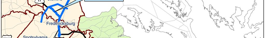
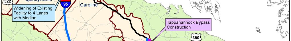
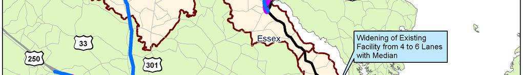

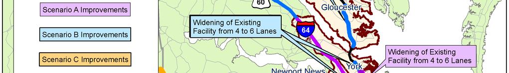
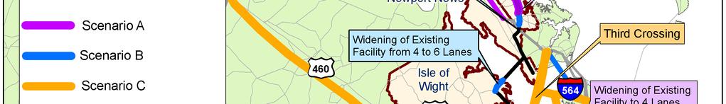
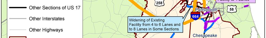
25 Figure 16. Future Improvements to the U.S. 17 Corridor Cambridge Systematics, Inc. Part III - U.S. 17 Corridor - Page 25
26 The relative effectiveness of these scenarios in meeting the U.S. 17 Corridor s freight transportation needs is summarized in the figure below. The Freight Congestion Index (FCI) is a measure of available capacity and use by trucks. It is a function of truck volume, link length, and number of lanes (U.S. capacity). A value of 1.00 represents the average state for the no-build scenario across all 11 corridors. Figure 17. Freight Congestion Index for the U.S. 17 Corridor Index Ratio No-Build A B C Scenario Key Project Recommendations Key recommendations for projects located within the U.S. 17 Corridor include: High-Priority Projects: Construct the U.S. 460 Expressway between Suffolk and I-295 near Petersburg. U.S. 460 between the Suffolk bypass and I-295 has very heavy truck volumes and is a key freight route between the Port areas of Hampton Roads and the Richmond Subregion. It also is a key freight route to I-95 and points north. This new limited access expressway will improve freight efficiency into and out of the Hampton Roads area and between Hampton Roads and Richmond. Widen U.S. 13/U.S. 58/U.S. 460 between I-664 and the Suffolk Bypass. Adding capacity to this link will alleviate congestion and improve freight flows into and out of the terminal facilities in Hampton Roads via the U.S. 460 Corridor. This improvement will be especially helpful in conjunction with the U.S. 460 Expressway project. Widen I-64 between Hampton Roads and Richmond. This portion of I-64 experiences a high level of background traffic and is the major truck artery into and out Part III - U.S. 17 Corridor - Page 26 Cambridge Systematics, Inc.
27 of Hampton Roads. Adding capacity to I-64 will alleviate this freight transportation bottleneck. Widen U.S. 17 to eight lanes between I-95 and VA Route 749 and to six lanes between VA Route 749 and VA Route 705 near Fredericksburg. This portion of U.S. 17 experiences a high level of background traffic and 16 percent combination unit (CU) trucks. Expanding U.S. 17 in this area will alleviate this freight transportation bottleneck. Add capacity to U.S. 17/U.S. 15/U.S. 29 near Warrenton and to U.S. 15/U.S. 29 between Warrenton and Prince William County. Widening these roadway sections will alleviate a freight transportation bottleneck at the confluence of the U.S. 17, U.S. 29, and I-66 Corridors. Construct the Hampton Roads Third Crossing. This project will improve total mobility across the Hampton Roads Subregion, provide new access to Norfolk International Terminals and Naval Base, improve access to the Newport News Marine Terminal and Newport News Shipbuilding and Dry-Dock Company, improve access to the Portsmouth Marine Terminal and Portsmouth Naval facilities, and connect to existing expressways on the Peninsula and on the Southside. Construct the I-564 Intermodal Connector. This project will extend I-564 and freight rail lines to the Norfolk International Terminals. It will provide a safe, highspeed, highway and rail connection from existing I-564 to the Norfolk International Terminals and the Norfolk Naval Station improving access to these facilities while reducing vehicle and truck traffic on the adjacent local roadways. Complete Port-Related Rail Improvement Projects. These projects consist of capacity improvements for the Norfolk International Terminals on-dock rail yard and the Norfolk and Portsmouth Belt Line rail yard, the Route 164 median rail connector, and for the Craney Island Connector. Pursue barge service between Hampton Roads and the Port of Richmond. This project has the potential to divert some freight traffic away from I-64, U.S. 460, and the rail lines between Hampton Roads and Richmond. Implement the National Gateway project. The National Gateway is a coordinated program of multistate improvements to CSX rail lines aimed at improving doublestack rail connections between Mid-Atlantic and Midwestern markets. Implement the Heartland Corridor project, the various Hampton Roads container terminal on-dock rail access projects, and the new Maersk Terminal interchange. These projects will improve the economic competitiveness of the U.S. 17 Corridor and of the Commonwealth as a whole. A more detailed description of the freight transportation projects identified for the U.S. 17 Corridor is provided in Table 11. Cambridge Systematics, Inc. Part III - U.S. 17 Corridor - Page 27
28 Table 11. U.S. 17 Multimodal Corridor Project List Route Project Description From To Distance (Miles) Impact on Freight Transportation Activity a Scenario Included in Freight Plan? U.S. 17 Widen to 4 Lanes 2.6 Mile South Cedar Road U.S. 17 U.S. 17 U.S. 17 U.S. 17 U.S. 17 U.S. 17 Rural 4 Lane with Urban 6 Lane with Urban 6 Lane with Urban 6 Lane with Urban 6 Lane with Urban 6 Lane with George Washington Memorial Highway South Cedar Road Interchange Low A Cedar Road Low B Cedar Road Great Bridge Boulevard Low B College Drive Chesapeake CL Low B Bennets Pasture Road Harbour View Drive Low B Brewers Neck Boulevard Newport News CL/Brick Kiln Creek U.S. 17 Widen from 4 to 6 Lanes Mile South Route 620 U.S. 17 U.S. 17 U.S. 17 Urban 6 Lane with Urban 6 Lane with Rural 4 Lane with South End James River Bridge Low B Cool Road Low B Mile North Route Low A Route 1204/Toll Plaza Main Street South Low B George Washington Memorial Highway John Clayton Memorial Highway Low B Route Route 17 North Low B U.S. 17 Tappahanock Bypass Proposed 360 Connector Route 17 North Low B U.S. 17 U.S. 17 Rural 4 Lane with Rural 4 Lane with Caroline CL Route 2/17 Bus Medium B Route 2/17 Bus Bus Route Low B Part III - U.S. 17 Corridor - Page 28 Cambridge Systematics, Inc.
29 Route Project Description From To Distance (Miles) U.S. 17 U.S. 17 U.S. 17 U.S. 17 U.S. 13 U.S. 13 U.S. 58 U.S. 460 U.S. 29 U.S. 58 U.S. 58 Rural 4 Lane with Rural 4 Lane with Urban 8 Lane with Urban 6 Lane with Rural 4 Lane with Impact on Freight Transportation Activity a Scenario Route 301 Spotsylvania CL Medium B Route 608 Route Medium B Included in Freight Plan? I-95 Route High B Yes Route 749 Route 705 South High B Yes North Carolina State Line Carolina Road Low A Capacity Improvements I-664 Suffolk Bypass High C Yes Add 1 Lane to each Direction Urban 6 Lane with Martin Luther King Jr. Freeway Extension Project Route 17 Prince William County Line High C Yes Manning Bridge Road Suffolk Bypass High B Yes Martin Luther King Jr. Extension I-264 London Boulevard High A U.S. 460 Urban 4 Lane with Kings Fork Road Suffolk Bypass High B Yes U.S. 460 b Route 460 Expressway I-295 Suffolk CL High C Yes I-64 Pavement Rehab and Widening I-64 Widen 6 Lanes + 2 HOV Lanes 1.00 Mile East of Route 249 I-64 Widen from 4 to 6 Lanes East Route 143 Interchange Route 199/Newman Road High B Yes Route 199 Fort Eustis Boulevard High B Yes West Route 143 Interchange Medium A Cambridge Systematics, Inc. Part III - U.S. 17 Corridor - Page 29
30 Route Project Description From To Distance (Miles) I-64 Widen to 8 Lanes with Peak HOV I-64 Widen 6 Lanes + 2 HOV Lanes I-64 Widen to 6 Lanes + HOV Lanes I-64 Widen to 6 Lanes + HOV L and CD Road I-64 Widen 6 Lanes + 2 HOV Lanes I-95 Rural 8 Lane with I-95 Rural 8 Lane with I-95 Add 2 Lane CD Road each Direction I-95 Add 3 Lane CD Road each Direction I-95 Add 2 Lane CD Road each Direction VA 164 Construct Maersk Terminal Interchange West Route 143 Interchange Impact on Freight Transportation Activity a Scenario Route Medium A Fort Eustis Boulevard Jefferson Avenue Medium B 1.17 Mile East Battlefield Boulevard 0.87 Mile West Southbound I Low A Battlefield Boulevard I Low B Included in Freight Plan? I-464 I-264/I High B Yes Route 30 Route High B Yes Route 207 Route High B Yes Route 608 Route High B Yes Route 3 Route High B Yes Route 17 Route High B Yes At Maersk Terminal High A I-564 Intermodal Connector I-564 Norfolk Naval Base/ N.I.T. Hampton Roads Third Crossing High A High C National Gateway High C Yes Heartland Corridor High A Yes Part III - U.S. 17 Corridor - Page 30 Cambridge Systematics, Inc.
31 Route Project Description From To Distance (Miles) Port-Related Rail Improvement Projects Including Craney Island Connector Norfolk International Terminal Projects Portsmouth Marine Terminal Projects Newport News Marine Terminal Projects Craney Island Marine Terminal Short-Haul Sprint Trains Marine Highway Service Expansion Impact on Freight Transportation Activity a Scenario Included in Freight Plan? High C Yes High C Yes High C Yes High C Yes High C Yes High C Yes High C Yes a: The impact on freight transportation activity column indicates the relative impact a given project has on freight mobility as compared to the relative impact it has on mobility in general. It consists of three categories: High these projects provide a greater relative impact to the important activity of moving freight than other projects considered. Medium these projects benefit both freight and non-freight transportation activity to an important degree. Low while valuable to both freight and non-freight transportation activity, these projects have a lower relative impact on freight transportation activity than those in the medium- or high-level categories. b: A portion of the relocated U.S. 460 Expressway is located within the U.S. 17 Corridor the planned expressway continues to I-295 near Petersburg. Cambridge Systematics, Inc. Part III - U.S. 17 Corridor - Page 31
32 Conclusions The primary conclusions of the U.S. 17 Corridor freight transportation profile are: The highest priority freight transportation infrastructure recommendations for the Corridor include construction of the U.S. 460 Expressway between Suffolk and I-295, the widening of U.S. 13/U.S. 58/U.S. 460 between I-664 and the Suffolk Bypass, the widening of U.S. 17 between I-95 and VA 705 near Fredericksburg, widening I-64 between Hampton Roads and Richmond, constructing the I-564 Intermodal Connector, the completion of the port-related rail improvement projects, and the construction of the Hampton Roads Third Crossing. U.S. 17 is a freight transportation bottleneck in the Fredericksburg area. The Norfolk Southern Virginia east-west mainline is a bottleneck from Hampton Roads through Blackstone. Combined, the freight-intensive, retail, and goods movement industries account for 36 percent of total U.S. 17 employment, significantly greater than the 31 percent average for Virginia as a whole. Over 81 percent of the total freight tonnage (inbound, outbound, internal, and through) moving within the Corridor is hauled by truck with just over 15 percent hauled by rail. Over 70 percent of the total freight tonnage moving within the Corridor is through traffic. The overall pavement condition of U.S. 17 in Virginia is very poor. Conditions in Spotsylvania County are fair, but conditions in every other jurisdiction are either poor or very poor. U.S. 17 enables access to air cargo facilities at Norfolk International Airport. Part III - U.S. 17 Corridor - Page 32 Cambridge Systematics, Inc.