USACE Integration of Metrics
|
|
|
- Ashlee Harrison
- 5 years ago
- Views:
Transcription


1 USACE Integration of Metrics CMANC Annual Fall Meeting Anne K. Sturm, P.E. Navigation and Coastal Business Line Manager South Pacific Division 11 October 2012 US Army Corps of Engineers CORNERSTONE OF THE SOUTHWEST!


2 Corps Navigation Mission Provide safe, reliable, efficient, effective and environmentally sustainable waterborne transportation systems for movement of commerce, national security needs, and recreation.
3 27 Ports and Harbors SPD Background 5 Major Commercial Ports with depth <40 7 Minor Commercial Ports with depths between Small Craft Harbors Ports are #1 in US for Value Shipped Ports are #3 in US for Tonnage > 429 Miles of Navigation Channels 35 Miles of Navigation Structures Dredge ~10-15 million Cubic Yards / Year High Rate of Return: $40-60 million in Dredging yields $192 billion in commerce. 3
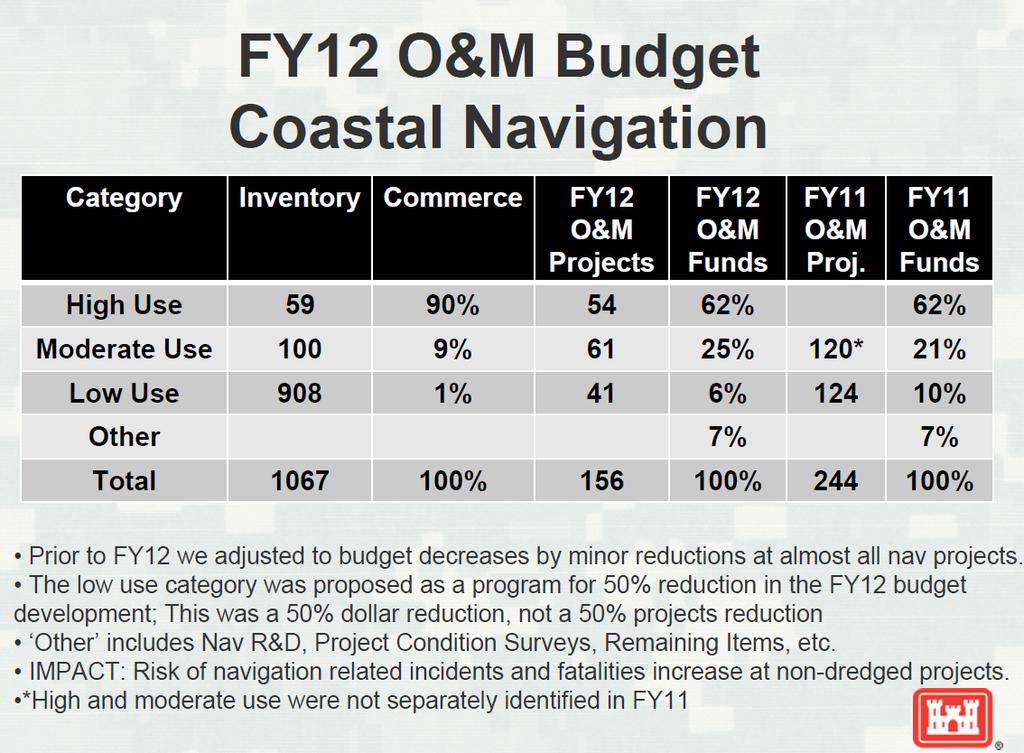
4 Navigation Program Southwestern Challenges Division Constrained federal budget. Several years of flat / reduced funding. Rapidly increasing cost of dredging: Ocean disposal Beneficial re-use Environmental monitoring and compliance In FY12, 50% reduction in low use navigation projects program. Need for nationally consistent, transparent, repeatable metrics (data availability).
5
6 Budget Metrics Performance based approach Safety, Critical Harbors of Refuge, National Security, Coast Guard Presence, Subsistence, Major transportation hubs (ferry). Focuses funding on the highest priority capital investments and maintenance activities. Use of Risk and Reliability factors Relative Risk Ranking (5x5 Matrix) Channel Portfolio Tool (CPT) Coastal Structures Management, Analysis, and Ranking Tool (CSMART)
7 OMBIL Navigation Linkages WCSC Waterborne Commerce Statistics Center Domestic and Foreign tonnage / ton-miles & trips by commodity for major ports and waterways Dock-level, origin-to-destination routing (Corps-use only) Aggregated data already published at the project level DIS Dredging Information System Dredging activity from pre-bid through completion Includes location, quantity, type of dredge, responsible District List dates of bid advertisement, bid opening, contract award, and small business set-aside restrictions Reports gov t estimate, all contractor bids, winning bidder, and upon completion actual costs and dredge quantity LPMS Lock Performance Monitoring System
8 Budget Worksheet Table F-14: 111 Columns Overall (not all columns applicable to all projects) (64) Harbor/Waterway Type High/Mod/Low Use; Deep/Shallow, etc. (76) Commercial Tonnage (OMBIL) (77) 5-Year Average Commercial Tonnage (OMBIL) (82) 5-Year Avg total O&M costs/ 5-Year Avg Annual Commercial Tonnage (83) Total Value of Foreign Cargo (OMBIL) (84) Value of Export Cargo (OMBIL)
9 Table F-14 continued: Budget Worksheet - Several columns related to Benefit-Cost Ratios - (97) Consequences: penalty if not funded (text) - (98/99) Remarks: District s may reference CA Dept of Fish and Game or NOAA Fisheries Commercial Fishery Landing Data; Other related Federal Initiatives (DOT, etc); Environmental Benefits; etc. (text) - ( ) Channel Portfolio Tool (5 Yr Average Tonnage & Cargo Value at risk for deepest 5 feet)
10 Channel Portfolio Tool (CPT) Background CPT is a web-based decision-support tool which helps convey the importance of Corps dredging activities to the efficient movement of maritime commerce. Developed with two primary objectives in mind: Consistent, objective allocation of Harbor Maintenance Trust Fund (HMTF) outlays for Operations and Maintenance (O&M) Improved access to and understanding of the data provided by the Waterborne Commerce Statistics Center (WCSC)

11 Channel Portfolio Tool (CPT)

12 Spatial Join to Waterway Network Baltimore CPT spatially joins the docks in the WCSC database with the respective sub-reaches. Full network connectivity, ensuring that all transited channels are appropriately credited. Shortest-path routing allows for traffic transiting multiple projects. 12


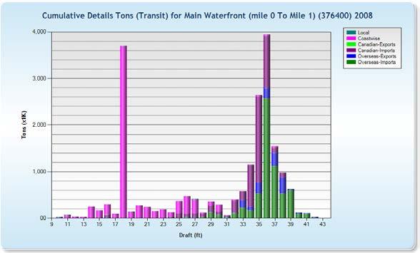
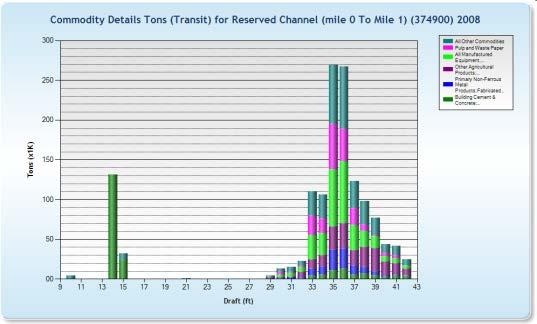
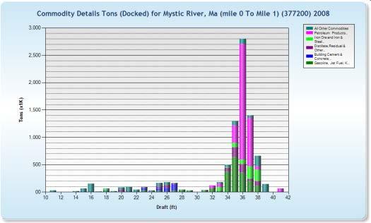
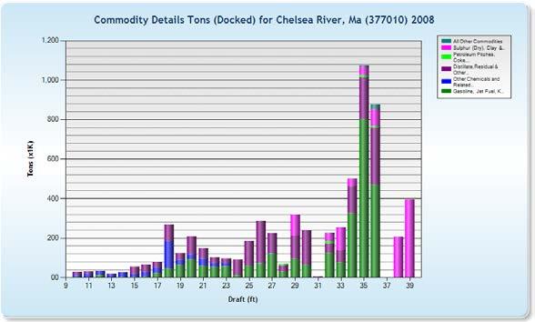
13 Depth-Utilization Analysis CPT can generate depth-utilization profiles showing the distribution of cargo across the range of maintained depths for any system of navigation channels. CPT then compares these tonnage-draft profiles to the segment controlling depths resulting from present shoaling conditions.
14 Focus on Shoal-vulnerable Cargo

15 Navigation Systems Defined CPT provides a flexible, accessible means of defining systems of maintained channels. Corps decision makers can now see the extent to which these navigation systems are utilized by commercial shipping.
16 Visualizing Project Utilization
17 CSMART Coastal Structures Management, Southwestern Analysis, and Division Ranking Tool Developed as part of the Coastal Inlets Research Program (CIRP) Vision: Optimally prioritize O&M funding such that benefits to the Nation are maximized and decisions can be defended. For FY14 Tool for HQ AM to prioritize CNS OCA s/ora s only. Rank the CNS in terms of those with the greatest risk. Metrics in CSMART include (but are not limited to): District Condition Rating (DCR) Total annual commercial tonnage supported (NDC) Annual commercial fish landings supported (NOAA-NMFS) Cruise and ferry passengers supported (USDOT) Coast Guard Incident reports Project classifications such as Harbor of Refuge and Subsistence Harbor. 17

18 Most CSMART data sets are spatially joined to structures within a user specified search radius CSMART Background
19 CSMART Features An array of relevant indicators of significance are used to evaluate the myriad roles of coastal structures within navigation projects. Commercial tonnage transiting near each structure gives an indication of economic significance. Source: Corps Waterborne Commerce Statistics Center (WCSC)

20 CSMART Rankings Structures are selected for analysis and comparisons using nested tree organized by MSC, District, and Project Selected metrics are then assigned linear weightings by the user to reflect decision maker priorities and rolled-up into an overall Structure Score for ranking structures for O&M outlays.
21 The Future Continuing to partner with our sponsors and interest groups to solve dredging and placement issues with the goal of realizing cost savings and improved efficiencies. Continue to develop and refine Asset Management methods for ranking existing projects. Goal: Deliver reliable infrastructure using a riskinformed asset management strategy President s Initiative: Double exports in next 5 years Improve development of the Compelling Case Beneficial Use of Dredge Material More granularity Cargo Value Life Safety factors
22 Discussion & Questions?