Burnett Lands Greenbank Road. Noise Impact Feasibility Report
|
|
|
- Cora Ferguson
- 5 years ago
- Views:
Transcription
1 Burnett Lands Greenbank Road Noise Impact Feasibility Report
2 BURNETT LANDS 3370 GREENBANK ROAD NOISE IMPACT FEASIBILITY REPORT Prepared for: Claridge Homes Prepared By: NOVATECH Suite 200, 240 Michael Cowpland Drive Ottawa, Ontario K2M 1P6 December 9, 2016 Novatech File: Ref: R

3 December 9, 2016 City of Ottawa Planning, Infrastructure and Economic Development Department Planning Services Branch 110 Laurier Ave. West, 4 th Floor Ottawa, Ontario K1P 1J1 Attention: Mr. Don Herweyer, Manager of Development Review South Reference: Burnett Lands Greenbank Road Noise Impact Feasibility Report Novatech File No.: Enclosed herein are three (3) copies of the Noise Impact Feasibility Report for the proposed development of the Burnett Lands located at 3370 Greenbank Road, Ottawa. The report is submitted in support of applications for Official Plan Amendment, Zoning By-Law Amendment and Draft Plan of Subdivision. It will address the environmental impact of noise from traffic on the outdoor living areas, and assess the feasibility of mitigation measures to attenuate noise to acceptable levels. Should you have any questions or comments, please do not hesitate to contact us. Sincerely, NOVATECH Greg MacDonald, P.Eng. Director, Land Development and Public Sector Projects Encl. M:\2011\111117\DATA\REPORTS\NOISE\ NOISE.DOCX Suite 200, 240 Michael Cowpland Drive, Ottawa ON K2M 1P6 Tel: Fax:
4 3370 Greenbank Road Noise Impact Feasibility Report TABLE OF CONTENTS 1.0 INTRODUCTION BACKGROUND AND REPORT LIMITATIONS CITY OF OTTAWA NOISE CONTROL GUIDELINES SOUND LEVEL CRITERIA NOISE ATTENUATION REQUIREMENTS PREDICTION AND MITIGATION OF NOISE LEVELS ROAD TRAFFIC NOISE LEVEL ANALYSIS CONCLUSIONS... 5 LIST OF TABLES Table 1: Traffic Parameters Table 2: Predicted Noise Levels LIST OF FIGURES Figure 1: Concept Plan Figure 2: Site Plan LIST OF DRAWINGS NC Noise Control Plan LIST OF APPENDICIES Appendix A Environmental Noise Control Guideline Excerpts Appendix B STAMSON Noise Modelling Results and Noise Control Plan Novatech i
5 3370 Greenbank Road Noise Impact Feasibility Report 1.0 INTRODUCTION Novatech has been retained by Claridge Homes (South Nepean) LP to prepare a Noise Impact Feasibility Report in support of an Official Plan Amendment (OPA), a Draft Plan of Subdivision, and a Zoning By-Law Amendment (ZBLA) to allow for the development of the lands at 3370 Greenbank Road, Ottawa. The site is planned to be developed with a mix of two to three storeys townhomes (247 units) including back-to-back townhomes and street orientated townhomes. In addition, two high rise residential blocks, which will generate an additional 420 residential units, are proposed on the south part of the realigned Greenbank Road and proposed Jockvale Road as shown on Figure 1. The proposed development provides access to the future district park- Half Moon Bay Park (along the Jock River), various trails, and to multiuse path identified in the Official Plan, South Nepean Secondary Plan, and South Nepean Community Design Plan. The study will assess the environmental impact of noise from traffic on the outdoor living areas, and review the feasibility of mitigation methods. Mitigation of in-door noise levels will not be discussed in this report since floor areas, window/door areas and building sections are not yet available. These components will be reviewed as part of the detailed subdivision design. 1.1 SITE LOCATION AND CONTEXT The Subject Site is approximately 15.5 hectares in area and is located immediate north of the Jock River, south of Strandherd Drive and between the Kennedy Burnett Stormwater Management Facility and the existing Greenbank Road as shown on Figure 2. The Burnett Municipal Drain is a tributary to the Jock River and travels through the subject site. The subject site currently has farm and accessory structures located near its southern boundary with an existing gravel access on to Greenbank Road. The remainder of the site is currently used for passive agriculture activities. The site is generally flat with a gentle slope from the northeastern corner to the southwestern corner. Novatech 1
6 M:\2011\111117\CAD\Design\Figures\ Fig1-CP.dwg, Fig1-CP, Dec 07, :39pm, mfang JOCK RIVER STREET 'E' HALF MOON BAY RD PROPOSED JOCKVALE RD STREET 'A' STREET 'D' MULTI STOREY 140 UNITS STREET 'F' STREET 'G' STOREY 140 UNITS MULTI PROPOSED GREENBANK RD 140 UNITS MULTI STOREY STREET 'H' Engineers, Planners & Landscape Architects Suite 200, 240 Michael Cowpland Drive Ottawa, Ontario, Canada K2M 1P6 Telephone (613) Facsimile (613) Website EXISTING GREENBANK RD 3370 GREENBANK RD. BURNETT LANDS CONCEPT PLAN 1 : DEC FIGURE 1 SHT11X17.DWG - 279mmX432mm
 from the City to permit")
7 3370 Greenbank Road Noise Impact Feasibility Report N Figure 2: Site Location (Base Map Source: GeoOttawa) The following describes the existing and planned land uses adjacent to the subject site: North: Lands to the north, owned by Caivan Communities, are currently under the development approval process and have recently obtained OPA and ZBLA approval (Amendment #144) from the City to permit High Rise and Mid Rise Mixed-Use Residential developments, Mid Rise Residential Dwellings, and a Neighbourhood Park as per Schedule 1- Land Use Plan, South Nepean Secondary Plan (Area 7). Further north of the Caivan Communities development is the planned Barrhaven Town Centre which will include a variety of retail uses to service the surrounding existing and planned residential developments. East: Lands east of the subject site contain a mixture of low density residential dwellings (single detached houses), a secondary school (St. Joseph Catholic High School), and an existing vegetated area. Greenbank Road currently forms the eastern boundary of the site. The realigned Greenbank Road will bisect the site as per the design by the City. South: The Jock River runs west east along the majority of the southern boundary of the property until it turns south near the southeastern corner of the site. The lands south of Jock River are within the Barrhaven South Community Design Plan and are intended for a future district park and residential uses as shown on Figure 17 of the Barrhaven South Community Design Plan. Novatech 2
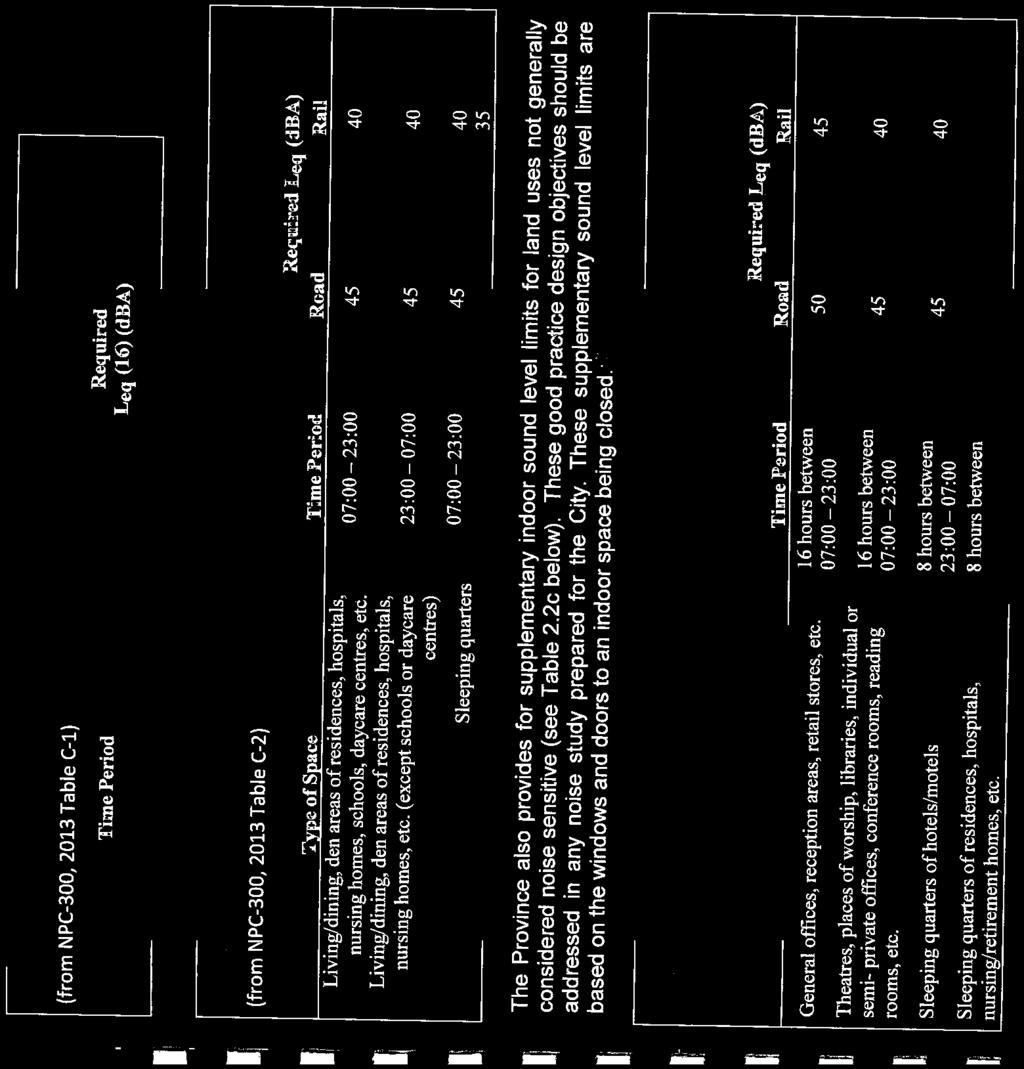
8 3370 Greenbank Road Noise Impact Feasibility Report West: The Kennedy Burnett stormwater management facility is located north west of the subject site and drains into the Jock River. Lands immediately west are currently vacant and intended for mostly conservation and residential uses as identified in Schedule B of the Official Plan. 2.0 BACKGROUND AND REPORT ASSUMPTIONS The City of Ottawa s Official Plan (OP) and Environmental Noise Control Guidelines (ENCG) stipulates that a noise study shall be prepared when a residential development is located within close proximity to surface transportation, stationary sources and aircraft noise sources. This report considers noise from traffic on the future Jockvale Road and Greenbank Road las all other sources of noise are located beyond the limits of consideration as outlined in Section 2.1 of the ENCG. Jockvale Road and Greenbank Road are classified as future collector and arterial roads, respectively, on Schedule E - Urban Road Network in the OP. Jockvale Road will be classified as a 2 lane urban collector and Greenbank Road will be classified as a 4 lane urban arterial divided road. This report also takes into consideration the future bus route on Greenbank Road. 3.0 CITY OF OTTAWA NOISE CONTROL GUIDELINES 3.1 Sound Level Criteria The City of Ottawa is concerned with noise from aircraft, roads, transitways, and railways, as expressed in Tables 2.2a: Sound Level Limit for Outdoor Living Areas Road and Rail, Table 2.2b: Sound Level Limit for Indoor Living Areas Road and Rail, and Table 2.2c: Supplementary Sound Level Limits for Indoor Spaces Road and Rail of the ENCG. As per Table 2.2a, the maximum suggested sound level for outdoor living areas between 7am and 11pm is 55 dba. For reference, Table 2.2a of the ENCG is included in Appendix A. Outdoor Living Area (OLA) is defined as follows: The outdoor amenity area provided for quiet enjoyment of the outdoor environment during the daytime period (i.e., backyards, terraces and patios). OLA noise levels are considered 3.0m from the building façade, 1.5m above grade. 3.2 Noise Attenuation Requirements When OLA sound levels are predicted to be approximately equal to or less than 55 dba attenuation measures are not required. If the predicted noise levels are found to exceed 55 dba, physical forms of mitigation is suggested and which may also include the provision of warning clauses to inform purchasers of the expected noise levels and specific mitigation measures. Novatech 3
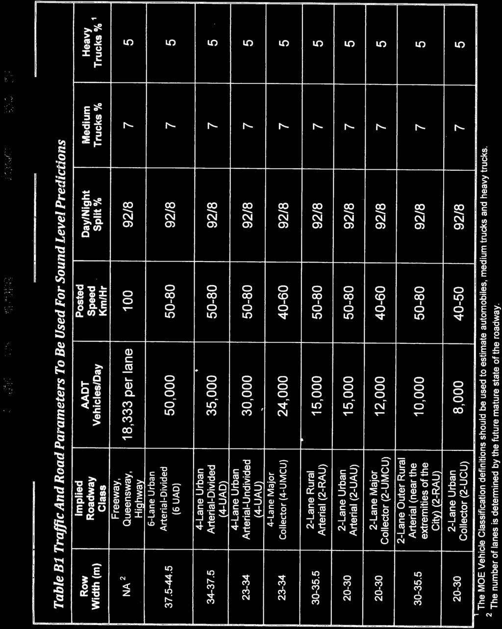
9 3370 Greenbank Road Noise Impact Feasibility Report 4.0 PREDICTION AND MITIGATION OF NOISE LEVELS 4.1 Road Traffic Table 1 outlines the traffic parameters used to predict the noise levels for the site. Table 1: Traffic Parameters Road Implied Roadway Class AADT Day Night Traffic Split (%) Medium Trucks Heavy Trucks Jockvale 2 Lane Urban Collector 8,000 92/8 7 5 Greenbank 4 Lane Urban Arterial Divided 35,000 92/8 7 5 In addition to the traffic volumes listed in Table 1, Greenbank Road will serve as a transit corridor for 144 bus trips per day. For reference, excerpts from the ENCG confirming the Jockvale Road and Greenbank Road AADT and an confirming the Greenbank Road future bus traffic volumes are included in Appendix A. 4.2 Noise Level Analysis The noise levels for the site were analyzed using version 5.03 of the STAMSON computer noise modelling program. For the most part, due to the planned orientation of the outdoor living areas, noise levels will be below the new OLA guideline of 55 dba. The exception is Block 8. Due to the backyards within Block 8 backing on to the district park physical mitigation of noise will be required. It is proposed to install a 2.2 meter high noise wall along these back yards which will reduce the noise level from dba to just below 60 dba. This is still above the new OLA guideline of 55 dba (the previous guideline as of January 2016 was 60 dba). To further reduce the noise level to the new criteria would result in a noise wall higher than 3.0 meters. A 3.0 m high barrier would be aesthetically unappealing to the local resident and its advantages (further reducing noise) would be minimal. Refer to the Noise Control Plan (Drawing Number NC), located in Appendix B for receiver locations, receiver elevations, and receiver distances to noise sources. The noise levels for all receiver locations generated from STAMSON are listed in Table 2 with detailed modeling results in Appendix B. Table 2: Predicted Noise Levels Receiver Name File Calculated Noise Level (dba), 7:00-23:00 Unattenuated Attenuated Mitigation Method OLA1 OLA1.te N/A OLA2 OLA2.te m Noise Barrier OLA3 OLA3.te m Noise Barrier OLA4 OLA4.te N/A OLA5 OLA5.te N/A Novatech 4
10 3370 Greenbank Road Noise Impact Feasibility Report It is also recommended that the following noise clauses be registered on title and incorporated into the agreement of purchase and sales: Purchasers/tenants are advised that sound levels due to increasing road traffic may occasionally interfere with some outdoor activities as the sound levels may exceed the sound level limits of the City and Ministry of the Environment. To help address the need for sound attenuation this development has been designed so as to provide an outdoor amenity area and indoor environment that is within provincial guidelines. The measures for sound attenuation utilized is an acoustic barrier to be owned and maintained by the City. 5.0 CONCLUSIONS This report confirms the predicted outdoor noise levels for the proposed residential development from the adjacent Jockvale Road and Greenbank Road are in excess of the City of Ottawa s and Ministry of the Environment guidelines. To mitigate the noise levels and inform potential buyers/tenants, the following noise attenuation measures are proposed: The installation of an acoustic noise barrier, 2.2 meters in height along the rear yards of Block 8 as indicated on the Noise Control Plan ( NC). The inclusion of a noise warning clause registered on title and incorporated into the purchase and sale agreements of the units requiring outdoor noise attenuation. Indoor noise mitigation methods and additional warning clauses to be registered on title and into the sales/rental agreements are to be confirmed during detailed design This report is respectfully submitted for City of Ottawa approval. NOVATECH Prepared by: Reviewed by: Mark Bowen, B.Eng. Project Manager Land Development Engineering Greg MacDonald, P.Eng. Director Land Development and Public Sector Infrastructure Novatech 5
11 3370 Greenbank Road Noise Impact Feasibility Report Appendix A Environmental Noise Control Guidelines Excerpts Novatech 6
12
13
14
15 3370 Greenbank Road Noise Impact Feasibility Report Appendix B STAMPSON Noise Modelling Results and Noise Control Plan Novatech 7
16 OLA 1 Unattenuated STAMSON 5.0 SUMMARY REPORT Date: :39:47 MINISTRY OF ENVIRONMENT AND ENERGY / NOISE ASSESSMENT Filename: ola1.te Time Period: Day/Night 16/8 hours Description: \\NOVATECH2008\Nova2\2011\111117\DATA\Calculations\Noise\ \Unatten uated\ola1 Road data, segment # 1: JOCKVALE (day/night) Car traffic volume : 6477/563 veh/timeperiod * Medium truck volume : 515/45 veh/timeperiod * Heavy truck volume : 368/32 veh/timeperiod * Posted speed limit : 60 km/h Road gradient : 1 % Road pavement : 1 (Typical asphalt or concrete) * Refers to calculated road volumes based on the following input: 24 hr Traffic Volume (AADT or SADT): 8000 Percentage of Annual Growth : 0.00 Number of Years of Growth : 0.00 Medium Truck % of Total Volume : 7.00 Heavy Truck % of Total Volume : 5.00 Day (16 hrs) % of Total Volume : Data for Segment # 1: JOCKVALE (day/night) Angle1 Angle2 : deg deg Wood depth : 0 (No woods.) No of house rows : 2 / 2 House density : 79 % Surface : 1 (Absorptive ground surface) Receiver source distance : / m Receiver height : 1.50 / 1.50 m Topography : 1 (Flat/gentle slope; no barrier) Reference angle : 0.00
17 Result summary (day) ! source! Road! Total! height! Leq! Leq! (m)! (dba)! (dba) 1.JOCKVALE! 1.50! 45.85! Total dba
18 Result summary (night) ! source! Road! Total! height! Leq! Leq! (m)! (dba)! (dba) 1.JOCKVALE! 1.50! 38.26! Total dba
19 TOTAL Leq FROM ALL SOURCES (DAY): (NIGHT): 38.26
20 OLA 2 Unattenuated STAMSON 5.0 SUMMARY REPORT Date: :55:23 MINISTRY OF ENVIRONMENT AND ENERGY / NOISE ASSESSMENT Filename: ola2.te Time Period: Day/Night 16/8 hours Description: \\NOVATECH2008\Nova2\2011\111117\DATA\Calculations\Noise\ \Unatten uated\ola2 Road data, segment # 1: JOCKVALE (day/night) Car traffic volume : 6477/563 veh/timeperiod * Medium truck volume : 515/45 veh/timeperiod * Heavy truck volume : 368/32 veh/timeperiod * Posted speed limit : 60 km/h Road gradient : 1 % Road pavement : 1 (Typical asphalt or concrete) * Refers to calculated road volumes based on the following input: 24 hr Traffic Volume (AADT or SADT): 8000 Percentage of Annual Growth : 0.00 Number of Years of Growth : 0.00 Medium Truck % of Total Volume : 7.00 Heavy Truck % of Total Volume : 5.00 Day (16 hrs) % of Total Volume : Data for Segment # 1: JOCKVALE (day/night) Angle1 Angle2 : deg deg Wood depth : 0 (No woods.) No of house rows : 0 / 0 Surface : 1 (Absorptive ground surface) Receiver source distance : / m Receiver height : 1.50 / 1.50 m Topography : 1 (Flat/gentle slope; no barrier) Reference angle : 0.00
21 Result summary (day) ! source! Road! Total! height! Leq! Leq! (m)! (dba)! (dba) 1.JOCKVALE! 1.50! 65.34! Total dba
22 Result summary (night) ! source! Road! Total! height! Leq! Leq! (m)! (dba)! (dba) 1.JOCKVALE! 1.50! 57.75! Total dba
23 TOTAL Leq FROM ALL SOURCES (DAY): (NIGHT): 57.75
24 OLA 3 Unattenuated STAMSON 5.0 SUMMARY REPORT Date: :13:07 MINISTRY OF ENVIRONMENT AND ENERGY / NOISE ASSESSMENT Filename: ola3.te Time Period: Day/Night 16/8 hours Description: \\NOVATECH2008\Nova2\2011\111117\DATA\Calculations\Noise\ \Unatten uated\ola3 Road data, segment # 1: JOCKVALE (day/night) Car traffic volume : 6477/563 veh/timeperiod * Medium truck volume : 515/45 veh/timeperiod * Heavy truck volume : 368/32 veh/timeperiod * Posted speed limit : 60 km/h Road gradient : 1 % Road pavement : 1 (Typical asphalt or concrete) * Refers to calculated road volumes based on the following input: 24 hr Traffic Volume (AADT or SADT): 8000 Percentage of Annual Growth : 0.00 Number of Years of Growth : 0.00 Medium Truck % of Total Volume : 7.00 Heavy Truck % of Total Volume : 5.00 Day (16 hrs) % of Total Volume : Data for Segment # 1: JOCKVALE (day/night) Angle1 Angle2 : deg deg Wood depth : 0 (No woods.) No of house rows : 0 / 0 Surface : 1 (Absorptive ground surface) Receiver source distance : / m Receiver height : 1.50 / 1.50 m Topography : 1 (Flat/gentle slope; no barrier) Reference angle : 0.00
25 Road data, segment # 2: GREENBANK (day/night) Car traffic volume : 28336/2464 veh/timeperiod * Medium truck volume : 2254/196 veh/timeperiod * Heavy truck volume : 1610/140 veh/timeperiod * Posted speed limit : 60 km/h Road gradient : 2 % Road pavement : 1 (Typical asphalt or concrete) * Refers to calculated road volumes based on the following input: 24 hr Traffic Volume (AADT or SADT): Percentage of Annual Growth : 0.00 Number of Years of Growth : 0.00 Medium Truck % of Total Volume : 7.00 Heavy Truck % of Total Volume : 5.00 Day (16 hrs) % of Total Volume : Data for Segment # 2: GREENBANK (day/night) Angle1 Angle2 : deg 0.00 deg Wood depth : 0 (No woods.) No of house rows : 3 / 3 House density : 78 % Surface : 1 (Absorptive ground surface) Receiver source distance : / m Receiver height : 1.50 / 1.50 m Topography : 1 (Flat/gentle slope; no barrier) Reference angle : 0.00
26 Road data, segment # 3: GREENBANK (day/night) Car traffic volume : 28336/2464 veh/timeperiod * Medium truck volume : 2254/196 veh/timeperiod * Heavy truck volume : 1610/140 veh/timeperiod * Posted speed limit : 60 km/h Road gradient : 2 % Road pavement : 1 (Typical asphalt or concrete) * Refers to calculated road volumes based on the following input: 24 hr Traffic Volume (AADT or SADT): Percentage of Annual Growth : 0.00 Number of Years of Growth : 0.00 Medium Truck % of Total Volume : 7.00 Heavy Truck % of Total Volume : 5.00 Day (16 hrs) % of Total Volume : Data for Segment # 3: GREENBANK (day/night) Angle1 Angle2 : 0.00 deg deg Wood depth : 0 (No woods.) No of house rows : 1 / 1 House density : 46 % Surface : 1 (Absorptive ground surface) Receiver source distance : / m Receiver height : 1.50 / 1.50 m Topography : 1 (Flat/gentle slope; no barrier) Reference angle : 0.00
27 Result summary (day) ! source! Road! Total! height! Leq! Leq! (m)! (dba)! (dba) 1.JOCKVALE! 1.50! 64.91! GREENBANK! 1.50! 45.85! GREENBANK! 1.50! 51.77! Total dba
28 Result summary (night) ! source! Road! Total! height! Leq! Leq! (m)! (dba)! (dba) 1.JOCKVALE! 1.50! 57.31! GREENBANK! 1.50! 38.25! GREENBANK! 1.50! 44.17! Total dba
29 RT/Custom data, segment # 1: GBANK (day/night) Bus: Traffic volume : 128/16 veh/timeperiod Speed : 60 km/h Data for Segment # 1: GBANK (day/night) Angle1 Angle2 : deg 0.00 deg Wood depth : 0 (No woods.) No of house rows : 3 / 3 House density : 78 % Surface : 1 (Absorptive ground surface) Receiver source distance : / m Receiver height : 1.50 / 1.50 m Topography : 1 (Flat/gentle slope; no barrier) Reference angle : 0.00
30 RT/Custom data, segment # 2: GBANK (day/night) Bus: Traffic volume : 128/16 veh/timeperiod Speed : 60 km/h Data for Segment # 2: GBANK (day/night) Angle1 Angle2 : 0.00 deg deg Wood depth : 0 (No woods.) No of house rows : 1 / 1 House density : 46 % Surface : 1 (Absorptive ground surface) Receiver source distance : / m Receiver height : 1.50 / 1.50 m Topography : 1 (Flat/gentle slope; no barrier) Reference angle : 0.00
31 Result summary (day) ! source! Gen! Total! height! Leq! Leq! (m)! (dba)! (dba) 1.GBANK! 0.50! 26.28! GBANK! 0.50! 32.20! Total dba
32 Result summary (night) ! source! Gen! Total! height! Leq! Leq! (m)! (dba)! (dba) 1.GBANK! 0.50! 20.26! GBANK! 0.50! 26.18! Total dba
33 TOTAL Leq FROM ALL SOURCES (DAY): (NIGHT): 57.57
34 STAMSON 5.0 SUMMARY REPORT Date: :31:57 MINISTRY OF ENVIRONMENT AND ENERGY / NOISE ASSESSMENT OLA 4 Unattenuated Filename: ola4.te Time Period: Day/Night 16/8 hours Description: \\NOVATECH2008\Nova2\2011\111117\DATA\Calculations\Noise\ \Unatten uated\ola4 Road data, segment # 1: JOCKVALE (day/night) Car traffic volume : 6477/563 veh/timeperiod * Medium truck volume : 515/45 veh/timeperiod * Heavy truck volume : 368/32 veh/timeperiod * Posted speed limit : 60 km/h Road gradient : 1 % Road pavement : 1 (Typical asphalt or concrete) * Refers to calculated road volumes based on the following input: 24 hr Traffic Volume (AADT or SADT): 8000 Percentage of Annual Growth : 0.00 Number of Years of Growth : 0.00 Medium Truck % of Total Volume : 7.00 Heavy Truck % of Total Volume : 5.00 Day (16 hrs) % of Total Volume : Data for Segment # 1: JOCKVALE (day/night) Angle1 Angle2 : deg deg Wood depth : 0 (No woods.) No of house rows : 3 / 3 House density : 86 % Surface : 1 (Absorptive ground surface) Receiver source distance : / m Receiver height : 1.50 / 1.50 m Topography : 1 (Flat/gentle slope; no barrier) Reference angle : 0.00
35 Road data, segment # 2: GREENBANK (day/night) Car traffic volume : 28336/2464 veh/timeperiod * Medium truck volume : 2254/196 veh/timeperiod * Heavy truck volume : 1610/140 veh/timeperiod * Posted speed limit : 60 km/h Road gradient : 2 % Road pavement : 1 (Typical asphalt or concrete) * Refers to calculated road volumes based on the following input: 24 hr Traffic Volume (AADT or SADT): Percentage of Annual Growth : 0.00 Number of Years of Growth : 0.00 Medium Truck % of Total Volume : 7.00 Heavy Truck % of Total Volume : 5.00 Day (16 hrs) % of Total Volume : Data for Segment # 2: GREENBANK (day/night) Angle1 Angle2 : deg deg Wood depth : 0 (No woods.) No of house rows : 2 / 2 House density : 80 % Surface : 1 (Absorptive ground surface) Receiver source distance : / m Receiver height : 1.50 / 1.50 m Topography : 1 (Flat/gentle slope; no barrier) Reference angle : 0.00
36 Road data, segment # 3: GREENBANK (day/night) Car traffic volume : 28336/2464 veh/timeperiod * Medium truck volume : 2254/196 veh/timeperiod * Heavy truck volume : 1610/140 veh/timeperiod * Posted speed limit : 60 km/h Road gradient : 2 % Road pavement : 1 (Typical asphalt or concrete) * Refers to calculated road volumes based on the following input: 24 hr Traffic Volume (AADT or SADT): Percentage of Annual Growth : 0.00 Number of Years of Growth : 0.00 Medium Truck % of Total Volume : 7.00 Heavy Truck % of Total Volume : 5.00 Day (16 hrs) % of Total Volume : Data for Segment # 3: GREENBANK (day/night) Angle1 Angle2 : deg deg Wood depth : 0 (No woods.) No of house rows : 3 / 3 House density : 90 % Surface : 1 (Absorptive ground surface) Receiver source distance : / m Receiver height : 1.50 / 1.50 m Topography : 1 (Flat/gentle slope; no barrier) Reference angle : 0.00
37 Result summary (day) ! source! Road! Total! height! Leq! Leq! (m)! (dba)! (dba) 1.JOCKVALE! 1.50! 42.47! GREENBANK! 1.50! 43.12! GREENBANK! 1.50! 46.58! Total dba
38 Result summary (night) ! source! Road! Total! height! Leq! Leq! (m)! (dba)! (dba) 1.JOCKVALE! 1.50! 34.88! GREENBANK! 1.50! 35.52! GREENBANK! 1.50! 38.98! Total dba
39 RT/Custom data, segment # 1: GBANK (day/night) Bus: Traffic volume : 128/16 veh/timeperiod Speed : 60 km/h Data for Segment # 1: GBANK (day/night) Angle1 Angle2 : deg deg Wood depth : 0 (No woods.) No of house rows : 2 / 2 House density : 80 % Surface : 1 (Absorptive ground surface) Receiver source distance : / m Receiver height : 1.50 / 1.50 m Topography : 1 (Flat/gentle slope; no barrier) Reference angle : 0.00
40 RT/Custom data, segment # 2: GBANK (day/night) Bus: Traffic volume : 128/16 veh/timeperiod Speed : 60 km/h Data for Segment # 2: GBANK (day/night) Angle1 Angle2 : deg deg Wood depth : 0 (No woods.) No of house rows : 3 / 3 House density : 90 % Surface : 1 (Absorptive ground surface) Receiver source distance : / m Receiver height : 1.50 / 1.50 m Topography : 1 (Flat/gentle slope; no barrier) Reference angle : 0.00
41 Result summary (day) ! source! Gen! Total! height! Leq! Leq! (m)! (dba)! (dba) 1.GBANK! 0.50! 23.55! GBANK! 0.50! 27.01! Total dba
42 Result summary (night) ! source! Gen! Total! height! Leq! Leq! (m)! (dba)! (dba) 1.GBANK! 0.50! 17.53! GBANK! 0.50! 20.99! Total dba
43 TOTAL Leq FROM ALL SOURCES (DAY): (NIGHT): 41.68
44 OLA 5 Unattenuated STAMSON 5.0 SUMMARY REPORT Date: :50:00 MINISTRY OF ENVIRONMENT AND ENERGY / NOISE ASSESSMENT Filename: ola5.te Time Period: Day/Night 16/8 hours Description: \\NOVATECH2008\Nova2\2011\111117\DATA\Calculations\Noise\ \Unatten uated\ola5 Road data, segment # 1: JOCKVALE (day/night) Car traffic volume : 6477/563 veh/timeperiod * Medium truck volume : 515/45 veh/timeperiod * Heavy truck volume : 368/32 veh/timeperiod * Posted speed limit : 60 km/h Road gradient : 1 % Road pavement : 1 (Typical asphalt or concrete) * Refers to calculated road volumes based on the following input: 24 hr Traffic Volume (AADT or SADT): 8000 Percentage of Annual Growth : 0.00 Number of Years of Growth : 0.00 Medium Truck % of Total Volume : 7.00 Heavy Truck % of Total Volume : 5.00 Day (16 hrs) % of Total Volume : Data for Segment # 1: JOCKVALE (day/night) Angle1 Angle2 : deg deg Wood depth : 0 (No woods.) No of house rows : 3 / 3 House density : 81 % Surface : 1 (Absorptive ground surface) Receiver source distance : / m Receiver height : 1.50 / 1.50 m Topography : 1 (Flat/gentle slope; no barrier) Reference angle : 0.00
45 Road data, segment # 2: GREENBANK (day/night) Car traffic volume : 28336/2464 veh/timeperiod * Medium truck volume : 2254/196 veh/timeperiod * Heavy truck volume : 1610/140 veh/timeperiod * Posted speed limit : 60 km/h Road gradient : 2 % Road pavement : 1 (Typical asphalt or concrete) * Refers to calculated road volumes based on the following input: 24 hr Traffic Volume (AADT or SADT): Percentage of Annual Growth : 0.00 Number of Years of Growth : 0.00 Medium Truck % of Total Volume : 7.00 Heavy Truck % of Total Volume : 5.00 Day (16 hrs) % of Total Volume : Data for Segment # 2: GREENBANK (day/night) Angle1 Angle2 : deg deg Wood depth : 0 (No woods.) No of house rows : 2 / 2 House density : 80 % Surface : 1 (Absorptive ground surface) Receiver source distance : / m Receiver height : 1.50 / 1.50 m Topography : 1 (Flat/gentle slope; no barrier) Reference angle : 0.00
46 Road data, segment # 3: GREENBANK (day/night) Car traffic volume : 28336/2464 veh/timeperiod * Medium truck volume : 2254/196 veh/timeperiod * Heavy truck volume : 1610/140 veh/timeperiod * Posted speed limit : 60 km/h Road gradient : 2 % Road pavement : 1 (Typical asphalt or concrete) * Refers to calculated road volumes based on the following input: 24 hr Traffic Volume (AADT or SADT): Percentage of Annual Growth : 0.00 Number of Years of Growth : 0.00 Medium Truck % of Total Volume : 7.00 Heavy Truck % of Total Volume : 5.00 Day (16 hrs) % of Total Volume : Data for Segment # 3: GREENBANK (day/night) Angle1 Angle2 : deg deg Wood depth : 0 (No woods.) No of house rows : 3 / 3 House density : 90 % Surface : 1 (Absorptive ground surface) Receiver source distance : / m Receiver height : 1.50 / 1.50 m Topography : 1 (Flat/gentle slope; no barrier) Reference angle : 0.00
47 Result summary (day) ! source! Road! Total! height! Leq! Leq! (m)! (dba)! (dba) 1.JOCKVALE! 1.50! 40.01! GREENBANK! 1.50! 46.16! GREENBANK! 1.50! 44.93! Total dba
48 Result summary (night) ! source! Road! Total! height! Leq! Leq! (m)! (dba)! (dba) 1.JOCKVALE! 1.50! 32.41! GREENBANK! 1.50! 38.57! GREENBANK! 1.50! 37.33! Total dba
49 RT/Custom data, segment # 1: GBANK (day/night) Bus: Traffic volume : 128/16 veh/timeperiod Speed : 60 km/h Data for Segment # 1: GBANK (day/night) Angle1 Angle2 : deg deg Wood depth : 0 (No woods.) No of house rows : 2 / 2 House density : 80 % Surface : 1 (Absorptive ground surface) Receiver source distance : / m Receiver height : 1.50 / 1.50 m Topography : 1 (Flat/gentle slope; no barrier) Reference angle : 0.00
50 RT/Custom data, segment # 2: GBANK (day/night) Bus: Traffic volume : 128/16 veh/timeperiod Speed : 60 km/h Data for Segment # 2: GBANK (day/night) Angle1 Angle2 : deg deg Wood depth : 0 (No woods.) No of house rows : 3 / 3 House density : 90 % Surface : 1 (Absorptive ground surface) Receiver source distance : / m Receiver height : 1.50 / 1.50 m Topography : 1 (Flat/gentle slope; no barrier) Reference angle : 0.00
51 Result summary (day) ! source! Gen! Total! height! Leq! Leq! (m)! (dba)! (dba) 1.GBANK! 0.50! 26.60! GBANK! 0.50! 25.36! Total dba
52 Result summary (night) ! source! Gen! Total! height! Leq! Leq! (m)! (dba)! (dba) 1.GBANK! 0.50! 20.58! GBANK! 0.50! 19.34! Total dba
53 TOTAL Leq FROM ALL SOURCES (DAY): (NIGHT): 41.63
54 STAMSON 5.0 SUMMARY REPORT Date: :19:48 MINISTRY OF ENVIRONMENT AND ENERGY / NOISE ASSESSMENT Filename: ola2.te Time Period: Day/Night 16/8 hours Description: \\NOVATECH2008\Nova2\2011\111117\DATA\Calculations\Noise\ \Attenua ted\ola2\22mbarrier Road data, segment # 1: JOCKVALE (day/night) Car traffic volume : 6477/563 veh/timeperiod * Medium truck volume : 515/45 veh/timeperiod * Heavy truck volume : 368/32 veh/timeperiod * Posted speed limit : 60 km/h Road gradient : 1 % Road pavement : 1 (Typical asphalt or concrete) * Refers to calculated road volumes based on the following input: 24 hr Traffic Volume (AADT or SADT): 8000 Percentage of Annual Growth : 0.00 Number of Years of Growth : 0.00 Medium Truck % of Total Volume : 7.00 Heavy Truck % of Total Volume : 5.00 Day (16 hrs) % of Total Volume : Data for Segment # 1: JOCKVALE (day/night) Angle1 Angle2 : deg deg Wood depth : 0 (No woods.) No of house rows : 0 / 0 Surface : 1 (Absorptive ground surface) Receiver source distance : / m Receiver height : 1.50 / 1.50 m Topography : 2 (Flat/gentle slope; with barrier) Barrier angle1 : deg Angle2 : deg Barrier height : 2.20 m Barrier receiver distance : 3.60 / 3.60 m Source elevation : m Receiver elevation : m Barrier elevation : m Reference angle : 0.00
55 Result summary (day) ! source! Road! Total! height! Leq! Leq! (m)! (dba)! (dba) 1.JOCKVALE! 1.50! 59.97! Total dba
56 Barrier table for segment # 1: JOCKVALE (day) Barrier! Elev of! Road! Tot Leq! Height! Barr Top! dba! dba! ! 97.40! 55.84! 55.84! 4.20! 97.90! 55.26! 55.26! 4.70! 98.40! 54.87! 54.87! 5.20! 98.90! 54.63! 54.63! 5.70! 99.40! 54.49! 54.49! 6.20! 99.90! 54.40! 54.40! 6.70! ! 54.35! 54.35! 7.20! ! 54.31! 54.31! 7.70! ! 54.29! 54.29! 8.20! ! 54.27! 54.27!
57 Result summary (night) ! source! Road! Total! height! Leq! Leq! (m)! (dba)! (dba) 1.JOCKVALE! 1.50! 52.37! Total dba
58 Barrier table for segment # 1: JOCKVALE (night) Barrier! Elev of! Road! Tot Leq! Height! Barr Top! dba! dba! ! 97.40! 48.25! 48.25! 4.20! 97.90! 47.67! 47.67! 4.70! 98.40! 47.28! 47.28! 5.20! 98.90! 47.04! 47.04! 5.70! 99.40! 46.90! 46.90! 6.20! 99.90! 46.81! 46.81! 6.70! ! 46.76! 46.76! 7.20! ! 46.72! 46.72! 7.70! ! 46.70! 46.70! 8.20! ! 46.68! 46.68!
59 TOTAL Leq FROM ALL SOURCES (DAY): (NIGHT): 52.37
60 STAMSON 5.0 SUMMARY REPORT Date: :15:57 MINISTRY OF ENVIRONMENT AND ENERGY / NOISE ASSESSMENT OLA 3 Attenuated Filename: OLA3.te Time Period: Day/Night 16/8 hours Description: \\NOVATECH2008\Nova2\2011\111117\DATA\Calculations\Noise\ \Attenua ted\ola3\22mbarrier Road data, segment # 1: JOCKVALE (day/night) Car traffic volume : 6477/563 veh/timeperiod * Medium truck volume : 515/45 veh/timeperiod * Heavy truck volume : 368/32 veh/timeperiod * Posted speed limit : 60 km/h Road gradient : 1 % Road pavement : 1 (Typical asphalt or concrete) * Refers to calculated road volumes based on the following input: 24 hr Traffic Volume (AADT or SADT): 8000 Percentage of Annual Growth : 0.00 Number of Years of Growth : 0.00 Medium Truck % of Total Volume : 7.00 Heavy Truck % of Total Volume : 5.00 Day (16 hrs) % of Total Volume : Data for Segment # 1: JOCKVALE (day/night) Angle1 Angle2 : deg deg Wood depth : 0 (No woods.) No of house rows : 0 / 0 Surface : 1 (Absorptive ground surface) Receiver source distance : / m Receiver height : 1.50 / 1.50 m Topography : 2 (Flat/gentle slope; with barrier) Barrier angle1 : deg Angle2 : deg Barrier height : 2.20 m Barrier receiver distance : 5.70 / 5.70 m Source elevation : m Receiver elevation : m Barrier elevation : m Reference angle : 0.00
61 Road data, segment # 2: JOCKVALE (day/night) Car traffic volume : 6477/563 veh/timeperiod * Medium truck volume : 515/45 veh/timeperiod * Heavy truck volume : 368/32 veh/timeperiod * Posted speed limit : 60 km/h Road gradient : 1 % Road pavement : 1 (Typical asphalt or concrete) * Refers to calculated road volumes based on the following input: 24 hr Traffic Volume (AADT or SADT): 8000 Percentage of Annual Growth : 0.00 Number of Years of Growth : 0.00 Medium Truck % of Total Volume : 7.00 Heavy Truck % of Total Volume : 5.00 Day (16 hrs) % of Total Volume : Data for Segment # 2: JOCKVALE (day/night) Angle1 Angle2 : deg deg Wood depth : 0 (No woods.) No of house rows : 1 / 1 House density : 95 % Surface : 1 (Absorptive ground surface) Receiver source distance : / m Receiver height : 1.50 / 1.50 m Topography : 1 (Flat/gentle slope; no barrier) Reference angle : 0.00
62 Road data, segment # 3: GREENBANK (day/night) Car traffic volume : 28336/2464 veh/timeperiod * Medium truck volume : 2254/196 veh/timeperiod * Heavy truck volume : 1610/140 veh/timeperiod * Posted speed limit : 60 km/h Road gradient : 2 % Road pavement : 1 (Typical asphalt or concrete) * Refers to calculated road volumes based on the following input: 24 hr Traffic Volume (AADT or SADT): Percentage of Annual Growth : 0.00 Number of Years of Growth : 0.00 Medium Truck % of Total Volume : 7.00 Heavy Truck % of Total Volume : 5.00 Day (16 hrs) % of Total Volume : Data for Segment # 3: GREENBANK (day/night) Angle1 Angle2 : deg 0.00 deg Wood depth : 0 (No woods.) No of house rows : 3 / 3 House density : 84 % Surface : 1 (Absorptive ground surface) Receiver source distance : / m Receiver height : 1.50 / 1.50 m Topography : 1 (Flat/gentle slope; no barrier) Reference angle : 0.00
63 Road data, segment # 4: GREENBANK (day/night) Car traffic volume : 28336/2464 veh/timeperiod * Medium truck volume : 2254/196 veh/timeperiod * Heavy truck volume : 1610/140 veh/timeperiod * Posted speed limit : 60 km/h Road gradient : 2 % Road pavement : 1 (Typical asphalt or concrete) * Refers to calculated road volumes based on the following input: 24 hr Traffic Volume (AADT or SADT): Percentage of Annual Growth : 0.00 Number of Years of Growth : 0.00 Medium Truck % of Total Volume : 7.00 Heavy Truck % of Total Volume : 5.00 Day (16 hrs) % of Total Volume : Data for Segment # 4: GREENBANK (day/night) Angle1 Angle2 : 0.00 deg deg Wood depth : 0 (No woods.) No of house rows : 1 / 1 House density : 33 % Surface : 1 (Absorptive ground surface) Receiver source distance : / m Receiver height : 1.50 / 1.50 m Topography : 1 (Flat/gentle slope; no barrier) Reference angle : 0.00
64 Road data, segment # 5: GREENBANK (day/night) Car traffic volume : 28336/2464 veh/timeperiod * Medium truck volume : 2254/196 veh/timeperiod * Heavy truck volume : 1610/140 veh/timeperiod * Posted speed limit : 60 km/h Road gradient : 2 % Road pavement : 1 (Typical asphalt or concrete) * Refers to calculated road volumes based on the following input: 24 hr Traffic Volume (AADT or SADT): Percentage of Annual Growth : 0.00 Number of Years of Growth : 0.00 Medium Truck % of Total Volume : 7.00 Heavy Truck % of Total Volume : 5.00 Day (16 hrs) % of Total Volume : Data for Segment # 5: GREENBANK (day/night) Angle1 Angle2 : deg deg Wood depth : 0 (No woods.) No of house rows : 1 / 1 House density : 69 % Surface : 1 (Absorptive ground surface) Receiver source distance : / m Receiver height : 1.50 / 1.50 m Topography : 2 (Flat/gentle slope; with barrier) Barrier angle1 : deg Angle2 : deg Barrier height : 2.20 m Barrier receiver distance : 3.00 / 3.00 m Source elevation : m Receiver elevation : m Barrier elevation : m Reference angle : 0.00
65 Result summary (day) ! source! Road! Total! height! Leq! Leq! (m)! (dba)! (dba) 1.JOCKVALE! 1.50! 58.61! JOCKVALE! 1.50! 47.37! GREENBANK! 1.50! 44.86! GREENBANK! 1.50! 48.29! GREENBANK! 1.50! 47.71! Total dba
66 Barrier table for segment # 1: JOCKVALE (day) Barrier! Elev of! Road! Tot Leq! Height! Barr Top! dba! dba! ! 97.35! 53.70! 53.70! 4.20! 97.85! 52.93! 52.93! 4.70! 98.35! 52.43! 52.43! 5.20! 98.85! 52.08! 52.08! 5.70! 99.35! 51.87! 51.87! 6.20! 99.85! 51.79! 51.79! 6.70! ! 51.76! 51.76! 7.20! ! 51.75! 51.75! 7.70! ! 51.74! 51.74! 8.20! ! 51.74! 51.74! Barrier table for segment # 5: GREENBANK (day) Barrier! Elev of! Road! Tot Leq! Height! Barr Top! dba! dba! ! 97.35! 43.78! 43.78! 4.20! 97.85! 42.89! 42.89! 4.70! 98.35! 42.22! 42.22! 5.20! 98.85! 41.71! 41.71! 5.70! 99.35! 41.34! 41.34! 6.20! 99.85! 41.13! 41.13! 6.70! ! 41.04! 41.04! 7.20! ! 41.04! 41.04! 7.70! ! 41.10! 41.10! 8.20! ! 41.22! 41.22!
67 Result summary (night) ! source! Road! Total! height! Leq! Leq! (m)! (dba)! (dba) 1.JOCKVALE! 1.50! 51.02! JOCKVALE! 1.50! 39.78! GREENBANK! 1.50! 37.26! GREENBANK! 1.50! 40.69! GREENBANK! 1.50! 40.11! Total dba
68 Barrier table for segment # 1: JOCKVALE (night) Barrier! Elev of! Road! Tot Leq! Height! Barr Top! dba! dba! ! 97.35! 46.11! 46.11! 4.20! 97.85! 45.34! 45.34! 4.70! 98.35! 44.83! 44.83! 5.20! 98.85! 44.49! 44.49! 5.70! 99.35! 44.28! 44.28! 6.20! 99.85! 44.20! 44.20! 6.70! ! 44.17! 44.17! 7.20! ! 44.15! 44.15! 7.70! ! 44.15! 44.15! 8.20! ! 44.15! 44.15! Barrier table for segment # 5: GREENBANK (night) Barrier! Elev of! Road! Tot Leq! Height! Barr Top! dba! dba! ! 97.35! 36.18! 36.18! 4.20! 97.85! 35.29! 35.29! 4.70! 98.35! 34.62! 34.62! 5.20! 98.85! 34.12! 34.12! 5.70! 99.35! 33.75! 33.75! 6.20! 99.85! 33.53! 33.53! 6.70! ! 33.44! 33.44! 7.20! ! 33.44! 33.44! 7.70! ! 33.50! 33.50! 8.20! ! 33.62! 33.62!
69 RT/Custom data, segment # 1: GBANK (day/night) Bus: Traffic volume : 128/16 veh/timeperiod Speed : 60 km/h Data for Segment # 1: GBANK (day/night) Angle1 Angle2 : deg 0.00 deg Wood depth : 0 (No woods.) No of house rows : 3 / 3 House density : 84 % Surface : 1 (Absorptive ground surface) Receiver source distance : / m Receiver height : 1.50 / 1.50 m Topography : 1 (Flat/gentle slope; no barrier) Reference angle : 0.00
70 RT/Custom data, segment # 2: GBANK (day/night) Bus: Traffic volume : 128/16 veh/timeperiod Speed : 60 km/h Data for Segment # 2: GBANK (day/night) Angle1 Angle2 : 0.00 deg deg Wood depth : 0 (No woods.) No of house rows : 1 / 1 House density : 33 % Surface : 1 (Absorptive ground surface) Receiver source distance : / m Receiver height : 1.50 / 1.50 m Topography : 1 (Flat/gentle slope; no barrier) Reference angle : 0.00
71 RT/Custom data, segment # 3: GBANK (day/night) Bus: Traffic volume : 128/16 veh/timeperiod Speed : 60 km/h Data for Segment # 3: GBANK (day/night) Angle1 Angle2 : deg deg Wood depth : 0 (No woods.) No of house rows : 1 / 1 House density : 69 % Surface : 1 (Absorptive ground surface) Receiver source distance : / m Receiver height : 1.50 / 1.50 m Topography : 2 (Flat/gentle slope; with barrier) Barrier angle1 : deg Angle2 : deg Barrier height : 2.20 m Barrier receiver distance : 3.00 / 3.00 m Source elevation : m Receiver elevation : m Barrier elevation : m Reference angle : 0.00
72 Result summary (day) ! source! Gen! Total! height! Leq! Leq! (m)! (dba)! (dba) 1.GBANK! 0.50! 25.29! GBANK! 0.50! 28.72! GBANK! 0.50! 27.95! Total dba
73 Barrier table for segment # 3: GBANK (day) Barrier! Elev of! RT/CUST! Tot Leq! Height! Barr Top! dba! dba! ! 97.35! 23.77! 23.77! 4.20! 97.85! 22.88! 22.88! 4.70! 98.35! 22.22! 22.22! 5.20! 98.85! 21.72! 21.72! 5.70! 99.35! 21.35! 21.35! 6.20! 99.85! 21.14! 21.14! 6.70! ! 21.06! 21.06! 7.20! ! 21.06! 21.06! 7.70! ! 21.12! 21.12! 8.20! ! 21.23! 21.23!
74 Result summary (night) ! source! Gen! Total! height! Leq! Leq! (m)! (dba)! (dba) 1.GBANK! 0.50! 19.27! GBANK! 0.50! 22.70! GBANK! 0.50! 21.93! Total dba
75 Barrier table for segment # 3: GBANK (night) Barrier! Elev of! RT/CUST! Tot Leq! Height! Barr Top! dba! dba! ! 97.35! 17.75! 17.75! 4.20! 97.85! 16.86! 16.86! 4.70! 98.35! 16.20! 16.20! 5.20! 98.85! 15.70! 15.70! 5.70! 99.35! 15.33! 15.33! 6.20! 99.85! 15.12! 15.12! 6.70! ! 15.04! 15.04! 7.20! ! 15.03! 15.03! 7.70! ! 15.10! 15.10! 8.20! ! 15.21! 15.21!
76 TOTAL Leq FROM ALL SOURCES (DAY): (NIGHT): 52.14
77 K ROAD D ER DH N RA N DR A RT LE VA TA CK VA LE EE AN NB RD KR D SITE JO GR RE RD TU FU VALE ION CT CK JO NNE CO RD GREENBAN ST CK JO PARK 0.97ha / 2.40ac DR N R OO VE E AL KV C O RD Y BA RI LF M HA J N KEY PLAN NORTH BLO CK ROADWAY CLASSIFICATION AS PER CITY OF OTTAWA OFFICIAL PLAN, SCHEDULE F, CENTRAL AREA/INNER CITY NETWORK. BL OC K RECEIVER HEIGHT (m) OLA1 OLA2 OLA3 OLA4 OLA O BL 7 K C C K 14 O BL JO NK RO CK VA RE EN BA LE CK M:\2011\111117\CAD\Design\Figures\Noise\ NC.dwg, NC, Dec 07, :10pm, mfang CK AD G JO RO BL O AD BLOCK BL O CK G 0 91 RE EN 8 3 BA Y AD ROAD ELEVATION ROAD ELEVATION JOCKVALE GREENBANK JOCKVALE ROAD GREENBANK ROAD (m) (m) RO RECEIVER GROUND ELEVATION (m) NK DISTANCES TO NOISE SOURCE (m) RECEIVER INFORMATION 5 1 BA N O O D M A F RO AL H K 4 C C O L B 3 NOISE CONTROL PLAN TO BE READ IN CONJUNCTION WITH NOISE IMPACT ASSESSMENT (R-2016-???) PREPARED BY NOVATECH. REFER TO REPORT FOR THE TYPICAL WARNING CLAUSES TO BE REGISTERED ON TITLE AND PROPOSED NOISE MITIGATION MEASURES. BL OC K K 1. RECEIVER DATA TABLE F O BL 3 E 1 NOTES: 9 AD O 2 T C O BL 6 1 EE R 3 ET R 5 ST K OLA 3 O BL OC K ST RE E C 4 7 AL KV K C CK 19 BL 8 C JO O O BL K 1 RECEIVER - OUTDOOR LIVING AREA (OLA) BL BL K C 7 91 OC K O BL O BL 7 ST 9 CK A RE E 6 BLOCK T OLA 2 OLA BLOCK STREET D 78 OLA 1 OLA BLO CK PROPOSED 2.2m NOISE BARRIER OLA 5 PROPERTY LINE BLOCK M CA G ET BLOCK BLOCK 1 12 RE 910 RD LEGEND ST RU AN I BR N.T.S. STREET B 12 R VE RI E AV BLOCK 17 RIV ER NORMAL WATER LEVEL (NWL) NOTE: THE POSITION OF ALL POLE LINES, CONDUITS, WATERMAINS, SEWERS AND OTHER UNDERGROUND AND OVERGROUND UTILITIES AND STRUCTURES IS NOT NECESSARILY SHOWN ON THE CONTRACT DRAWINGS, AND WHERE SHOWN, THE ACCURACY OF THE POSITION OF SUCH UTILITIES AND STRUCTURES IS NOT GUARANTEED. BEFORE STARTING WORK, DETERMINE THE EXACT LOCATION OF ALL SUCH UTILITIES AND STRUCTURES AND ASSUME ALL LIABILITY FOR DAMAGE TO THEM. FOR REVIEW ONLY DESIGN SCALE LOCATION MWB CITY of OTTAWA 3370 GREENBANK ROAD CHECKED 1:750 MWB Engineers,Planners&LandscapeArchitects DRAWN SAM 0 1. No. ISSUED WITH DRAFT PLAN OF SUBDIVISION REVISION DEC 6/16 MWB DATE BY MWB APPROVED MWB Telephone Facsimile Website (613) (613) PROJECT No Suite 200, 240 Michael Cowpland Drive Ottawa, Ontario, Canada K2M 1P6 CHECKED 1:750 DRAWING NAME REV NOISE CONTROL PLAN REV # 1 DRAWING No NC PLANB1.DWG mmx707mm