CENTRAL ATLANTA TRANSPORTATION STUDY TABLE OF CONTENTS. Foreword...1. Study Objectives Study Process... 3
|
|
|
- Preston Harrington
- 5 years ago
- Views:
Transcription
1
2 TABLE OF CONTENTS Foreword...1 Study Objectives... 2 Study Process... 3 Findings and Recommendations... 5 Roadway/Parking... 5 Transit Bike/Pedestrian/Environment Policy Implementation Action Plan Immediate Implementation Projects Second Tier Projects Third Tier Projects... 18
3 Foreword Central Atlanta Progress, in conjunction with a number of public and private organizations, conducted a transportation planning study of the Central Atlanta area the Central Atlanta Transportation Study (CATS). The study is one element of a larger study of the Central Atlanta area, the Central Atlanta Action Plan (CA 2 P). The CATS study was a collaborative effort between a consultant team including Dames & Moore, Day Wilburn Associates and CRA Consulting. Georgia Institute of Technology contributed the services of Mr. H. Randal Roark, AIA, AICP to assist the project team. The CATS study was also coordinated with the concurrent preparation of a Bicycle and Pedestrian Facility Master Plan, conducted by MDG, Inc. under a separate contract with the PATH Foundation. Funding for the CATS study was provided through a combination of contributions by CAP members both public and private and additional public funds through the Atlanta Regional Commission. The CATS study updates the previous Downtown Transportation Management Study completed in This update was needed to re-evaluate transportation strategies based on more recent development and travel trends. In particular, the imminent redevelopment activity on the western side of downtown required an assessment of current and planned transportation systems. The CATS study assesses current transportation conditions and addresses anticipated future mobility needs within the areas of redevelopment and throughout the entire Central Atlanta area. The CATS study is documented in two reports. The Summary Report presents an overview of the study process and the findings and recommended Implementation Action Plan. A separate Technical Appendix documents the data obtained or collected during the study. Page 1
4 Study Objectives The CATS mission is to support a balanced, complete and integrated transportation system that encourages sustainable development patterns in central Atlanta. This mission is accomplished through achievement of specific study objectives: reinstate surface street continuity, balance street capacity with development systems and circulation needs, maximize transit activity, encourage walking, provide for bicycles, plan for future parking needs, manage special events, develop painless alternatives for mobility between Atlantic Steel and GWCC and destinations between, support construction of a centrally located multi-modal station, and aggressively pursue community support and funding for short range projects needed. Page 2
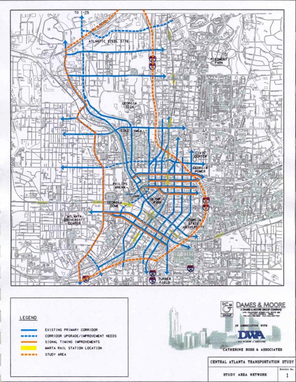
5 Study Process The CATS study area lies within the City of Atlanta and is roughly bounded by I-75/85 to the east, I-20 to the south, Northside Drive/Howell Mill Road to the west and Brookwood Station to the north. The complexity of this area and its transportation system required an innovative, two-phase study approach. The first phase involved a broad-based examination of existing and future conditions to identify proposed transportation strategies and the appropriate next steps to refine or pursue those strategies. This draft Conceptual Transportation Plan documents the results of the Phase I effort. Phase II of CATS will focus more detailed analyses where necessary to refine draft concepts and pursue specific implementation activities. Phase I of CATS included the following general study process: Solicit stakeholder input, Obtain available studies, plans and data, Study team review of data and issues, Study team assessment and conceptual recommendations, Identify next steps for each recommended action, and Document study findings. The CATS Phase I began with a stakeholder workshop. Participants included representatives from area businesses, property owners, developers, Georgia DOT, MARTA, City of Atlanta, Atlanta Regional Commission, Midtown Alliance and others. Interviews were also conducted with stakeholders who did not participate in the workshop in order to complete a comprehensive input process. The input received included a long list of both issues and opportunities, and created direction for the Phase I study. The study consultants then obtained and reviewed available studies, plans and data describing the land use and transportation characteristics of the area. Information compiled included traffic and transit data, land use plans, future travel estimates, currently planned infrastructure improvements and parking information. The study team conducted additional field reconnaissance to confirm and supplement this data. An inventory of planned development activity was also conducted. This inventory created a map and database of all major development activity within the Page 3
6 study area. The data obtained and collected is included in the Technical Appendix. The study team reviewed the study issues, input received, data obtained and previous studies. This review was first conducted independently, then as a collective study team. The study team combined its extensive and diverse local experience to identify specific transportation needs and potential solutions. The analyses relied primarily on previous studies and data. Finally, the study process, findings and recommendations of CATS Phase I are documented in this report. The resulting needs and recommendations are outlined in the following sections. Page 4
7 Findings and Recommendations The following section summarizes the study findings and recommendations. These are summarized in the areas of roadway/parking, transit, bike/pedestrian/environment, and policy. This section includes general recommendations, while specific recommended actions are recommended in the final section Implementation Action Plan. Roadway/Parking Findings Systems management Management of the existing transportation system capacity is an important issue that re-surfaced throughout the study process. And, improved utilization of the existing infrastructure often represents a cost-effective improvement strategy. The benefits of improved management were apparent in Central Atlanta during the 1996 Olympic Games. Atlanta demonstrated that coordinated management of various transportation systems provides dramatically increased capacity to efficiently move people and goods. Several good examples of system management are currently in operation, including MARTA s shuttle service to Atlanta Braves baseball games and Georgia DOT s Advanced Traffic Management System which provides up-to-date travel information, travel advisories and coordinated incident response. However, improved system management would be beneficial in other areas including traffic signal operations, special event traffic control and utilization of existing roadway capacity. Special event traffic The Central Atlanta area hosts frequent special events that pose unique demands on the transportation system. These special events are more irregular and varied in travel demands than events such as recurring baseball games. For example, events at the Phillips Arena, Georgia Dome, Georgia World Congress Center and Centennial Olympic Park take place at varied times of day and can run concurrently or overlap. These special events pose unique and varied demand on the transportation system. Improved management of these special event travel demands is needed to utilize the existing system most effectively. A variety of special event traffic and parking control scenarios should be developed and implemented based on the specific event scenario. Updated traffic signal timing Page 5
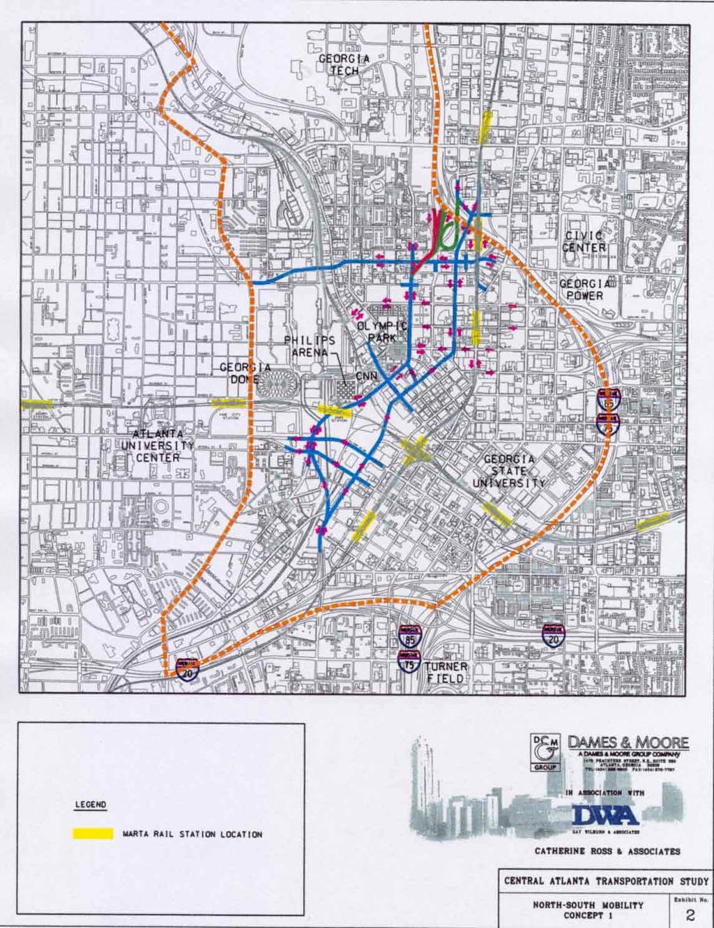
8 should be developed and implemented throughout downtown. The person-carrying capacity of select corridors should be maximized through conversion of existing travel lanes for reversible use, HOV, bus-only or other mode as appropriate. These strategies should be considered for either temporary or permanent operations as appropriate. System continuity East-west movement Northside Drive Service and loading The continuity of the existing transportation system was found to be deficient in several areas. Major roadways terminate at illogical locations. One-way streets, such as Spring Street and Techwood Drive, should generally be used in a system and should have logical termini. Continuous major arteries are important to providing a logical street network. Similar concepts should also be applied to future changes in the transit system. Long, simple transit routes are more user-friendly than routes that make numerous turns or are not long enough. Future changes in the street network or transit system should place high priority on establishing or maintaining system continuity. A review of the overall street network configuration and travel movements identified some interesting characteristics. Within the downtown business district, a modified grid system currently exists. However, east-west mobility is severely deficient as compared to north-south mobility. The traffic signal operations favor north-south movements, making east-west travel difficult. I-75 and the railroad limit the east-west connections in certain locations. Improved east-west mobility is needed through improved corridors and updated signal operations. North-south connections north of North Avenue and west of I-75 are deficient. Within the study area, the only northsouth connection north of North Avenue is Northside Drive (US 41). In this area, Georgia Tech creates an obstacle to north-south mobility. Critical improvements to the Northside Drive corridor are necessary to meet future mobility needs. (This general area includes the pending Atlantic Steel development.) Currently, the functions of service and loading are quite varied. Certain large facilities have self-contained off-street loading, including the Inforum, Atlanta Journal-Constitution, large hotels and others. In many areas of downtown, service and loading vehicles park on the street. However, these functions are often performed in designated No Parking Page 6
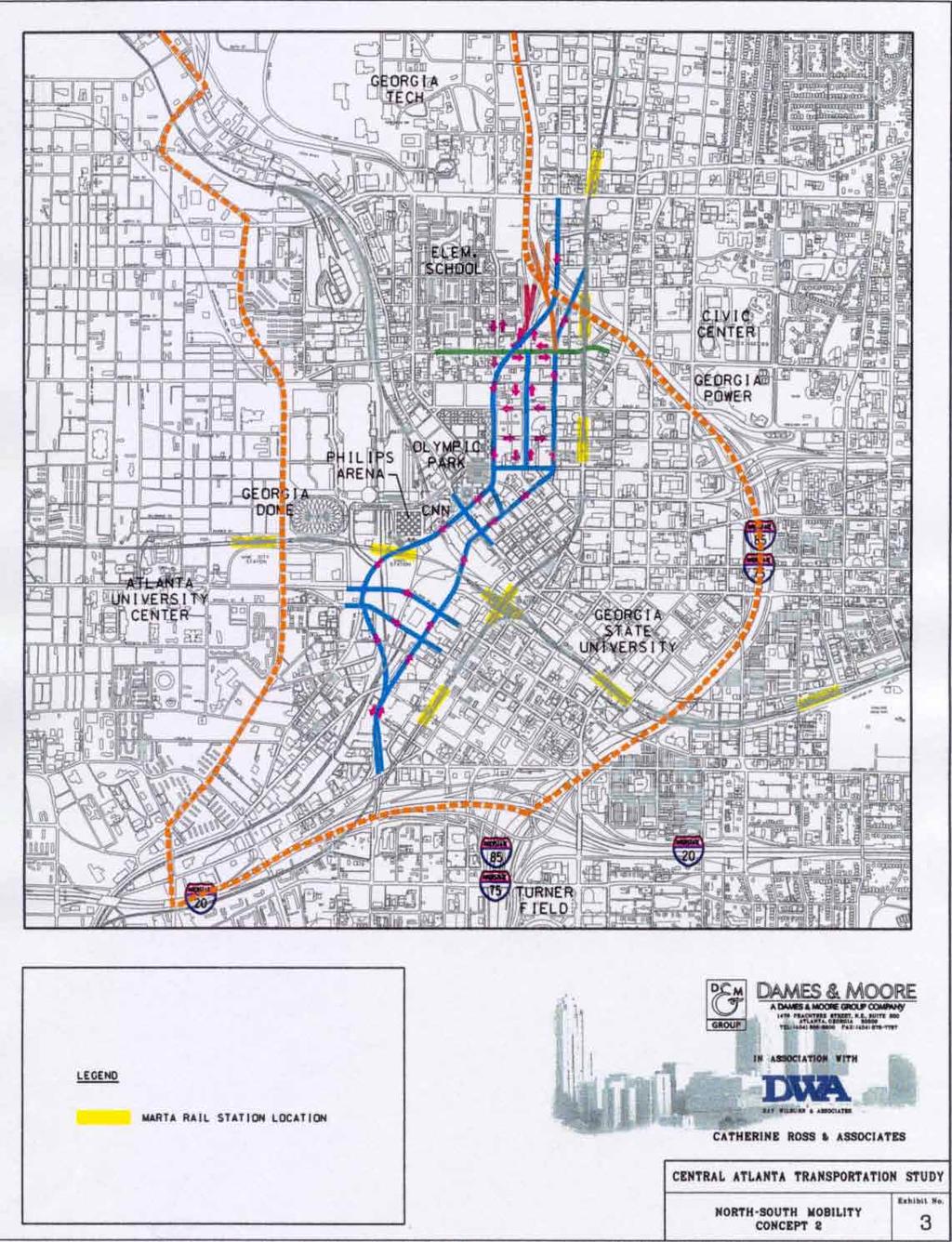
9 areas or from through-travel lanes. These functions are important to maintaining vibrant business activity downtown, and must be accommodated. These functions should be accommodated and performed in a manner that does not impact the safe and effective mobility of other street users. Multi Modal Passenger Terminal Techwood Dr/Spring St The planned Multi Modal Passenger Terminal will be constructed near the corner of Spring Street and Martin Luther King, Jr. Drive. This facility will provide an interface between commuter rail, bus, and rapid rail (MARTA) in downtown Atlanta. Accessibility to this facility will be critical to its long-term success. Superior accessibility should be sought for all modes, including auto, bus transit (intercity and local), rail transit, pedestrian and bicycle. Through downtown, Techwood Drive and Spring Street create a one-way pair system. These routes are important for connections to I-20 and I-75, and to north-south mobility through downtown. This system is currently incomplete and disjointed. The connectivity from Techwood Drive to I-20 lacks a direct route to the south. At the northern end of the pair, Techwood Drive changes from two-way to one-way without a strong connection from the northbound side of the pair (Spring Street). The Georgia DOT proposal to extend Techwood Drive to Spring Street addresses the deficiency at the southern end of the system, but the City of Atlanta opposes the current concept due to resulting impacts near the Castleberry Hill district. An improved connection is needed, and an alternative solution is being explored. An interim solution has been implemented by the City and Georgia DOT that utilizes Martin Luther King, Jr. Drive to connect between Techwood Drive and Spring Street. The Georgia DOT and City of Atlanta have recently announced plans to re-evaluate other alternatives. The northern end of the Techwood/Spring one-way pair system provides continuity with the Spring Street/West Peachtree one-way pair system through midtown. However, Techwood Drive changes from two-way to one-way at Alexander Street without a strong connection from northbound Spring Street. Furthermore, the ramps, to and from I-75 at Williams Street, lack direct connection(s) to the Techwood/Spring one-way pair. Currently, there are no proposals to address these deficiencies. Page 7
10 The Techwood Drive/Spring Street one-way pair system has the potential to provide a major role in north-south travel. However, this system needs to be refined and completed. The CATS study team developed several alternates and concluded that a more in-depth study of these specific issues, including connectivity to the Williams Street interchange, was needed. The City and Georgia DOT are continuing their efforts to identify an agreeable solution. The City has recently changed M.L.K. Drive to a two-way street between Spring Street and Techwood Drive as an interim arrangement while a permanent solution is developed. I-20 Access Parking The connectivity of Northside Drive to I-20 was reviewed. As previously mentioned, Northside Drive provides a critical north-south corridor to future mobility demands between I-75 and I-20. The current connection from Northside Drive to I- 20 is indirect and insufficient to meet future demands. A dramatic improvement to interstate access and mobility though this corridor should be further evaluated. The current supply and utilization of downtown parking was reviewed from available data and through field observations. Generally, the Central Atlanta area provides an adequate supply of parking. There are specific areas where parking is less available, but can be accommodated within an acceptable walking distance. For example, parking demand in the government services district (near the State Capitol and City and County offices) often exceeds adjacent supply, but parking can normally be found within several blocks. However, available parking is not well signed for visitors. Currently, most parking facilities are privately owned and operated, and offer some combination of public and permitonly parking. Designated public parking facilities are provided only at Underground Atlanta and adjacent to CNN Center and the Georgia Dome. The dispersed location of other public-accessible parking makes signing difficult. Surface lots are disappearing as infill and redevelopment occurs. While elimination of surface parking lots is desirable for many reasons, it has the effect of reducing the supply of public-accessible parking. New developments tend to provide parking only for patrons and limited visitor parking. Page 8
11 As infill and redevelopment continues, the desired total quantity of parking should be evaluated and monitored by a Transportation Management Association (TMA) or other downtown authority. The potential need for designated and well signed public parking, and concepts such as shared parking, should also be evaluated. Recommendations Update traffic signal operations Improve event traffic management Reconstruct and improve Alexander Street east-west corridor Enforce No-Parking regulations Identify and implement solution to Techwood Extension Improve access to I-75 from Spring Street and Techwood Drive Investigate long-term needs in the Northside Drive corridor from I-75 to I-20 Improve signage to visitor/public parking Evaluate potential need for designated public parking areas Encourage on-street parking only where short-term parking is compatible with adjacent land uses Creation of a Transportation Management Association (TMA) Page 9
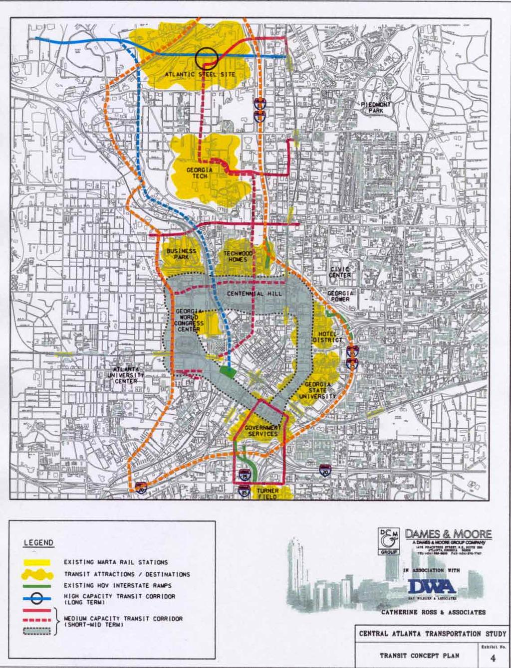
12 Transit Findings Downtown Atlanta is served by MARTA rail and bus transit. The MARTA rail system provides the backbone for the regions transit system. This system radiates from downtown to the north, northeast, east, south and west. This system is designed primarily for movements to and from the central city. In addition to MARTA rail and bus service, services from suburban counties include express bus from Cobb County and vanpool service from Douglas County. Four major local shuttle programs also operate within downtown. These are discussed further in the Technical Appendices. Several extensions of the MARTA rail network are currently planned or under consideration. Among the proposals is a light rail line from the Arts Center station, through the Atlantic Steel site to the Cumberland area in northwest Atlanta. In addition, MARTA has considered the feasibility of a connection from the North Line to Emory, Decatur and through south DeKalb County. The line would interface with the north line at the Lindbergh or Arts Center station. These proposals are still under consideration. Other planned additions to this transit system include commuter rail that will terminate at the Multi Modal Passenger Terminal and additional suburban bus systems including express routes to downtown. The HOV system provides the likely routes for express bus systems to access downtown, and is currently being expanded into suburban counties. An overall assessment of transit service to and within Central Atlanta suggests that additional improvements are needed to better serve development areas and increasing travel demands. Circulation Improved circulation is needed in downtown, midtown and within emerging activity centers. The MARTA rail system excels at moving people to downtown and other high density areas, but does not serve neighborhoods or points of origin very well. In downtown, the local bus routes are designed for travel from point-to-point, rather than circulation within downtown. The Central Atlanta transit system should provide three interconnected types of services: 1) long trips Page 10
13 (rail and express bus), 2) corridor movements (local and shuttle bus), and 3) circulation within downtown (fixed route circulator). Connections Serving growth areas Improved intermodal connectivity and transfer and terminal facilities will be needed as the transit system is expanded. MARTA s Five Points and Arts Center stations provide examples of how local bus currently interfaces with rail. The planned Multi Modal Passenger Terminal will provide an important interface with commuter rail. Additional and expanded facilities are necessary including potential circulation systems, bicycle facilities and parking facilities. Existing and potential future transit service to high growth areas west of downtown were also evaluated. The planned Atlantic Steel development is being designed as a Transit Supportive Development. Transit connections from this area to midtown and downtown will be very important. Initially, this mixed-use development will be linked to MARTA s Arts Center Station via a shuttle bus system operating primarily in a dedicated facility. The ARC s current draft Regional Transportation Plan includes a planned rail extension from Arts Center, through Atlantic Steel and ultimately to Cobb County to the northwest. Initial review of certain west side transit alternatives suggests that a separate north-south rail corridor west of I- 75 would compete with existing rail through midtown if the NW extension connects to the Arts Center station. One viable alternative would be to create a high capacity bus corridor from Atlantic Steel to downtown within, or along, the Northside Drive corridor, potentially accessing the Multi Modal Passenger Terminal. A second viable alternative would terminate the NW rail extension at the Multi Modal Passenger Terminal rather than the Arts Center station. This alternative would be adjacent to Atlantic Steel in the Northside Drive corridor and serve other emerging developments west of downtown. These and other potential alternatives are influenced as much by long distance trip patterns from outside Central Atlanta as by local trip making. Page 11
14 Recommendations Create downtown circulator systems Create on-street bus-only lanes in high demand corridors Establish shuttle from Atlantic Steel to Arts Center Pursue NW rail line serving Atlantic Steel to either Arts Center or Multi Modal Passenger Terminal Page 12
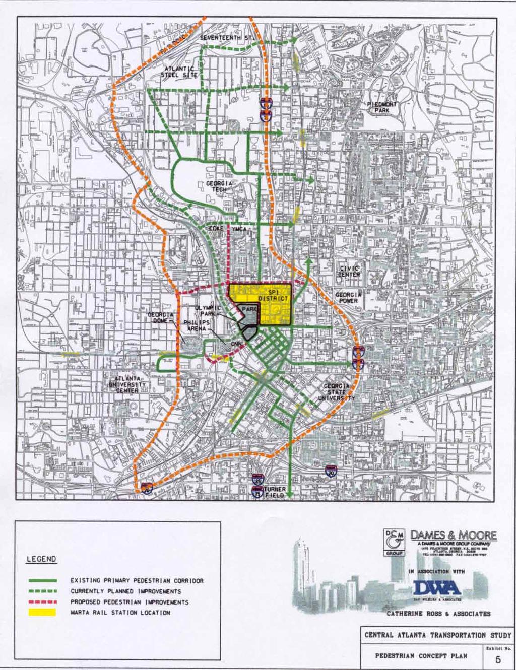
15 Bike/Pedestrian/Environment Findings Bicycle, pedestrian and urban environment elements of the CATS study are interwoven with other urban design components of CA 2 P. The CATS effort focuses primarily on the overall transportation system, rather than specific design features. This analysis provides a system of the review/analysis of sidewalks and bicycle facilities and assesses how these facilities contribute to other transportation modes. Walkable downtown A field review of existing sidewalk conditions confirmed that central Atlanta is walkable in terms of building density and continuity of sidewalks. There are some very good examples of pedestrian facilities, particularly the Peachtree Street and International Boulevard corridors that were improved in preparation for the 1996 Olympic Games. The pedestrian signage and wayfinding kiosks along Peachtree Street and International Boulevard are excellent. However, more of these types of pedestrian features and signing are needed, as shown in Exhibit 5. Maintenance Several deficiencies were noted during a field review of existing sidewalk conditions. Maintenance of existing sidewalks need improvement. In particular, the replacement of sidewalks following utility repair is generally not performed to the standards and quality of the original installation. In addition, adequate resources to repair and maintain sidewalks are needed. Accessibility for the physically challenged is not consistently provided throughout downtown. Sidewalk clutter (i.e. newspaper stands, sandwich board signs and illegally parked cars) also presents an obstacle to pedestrian mobility. Bicycle system There are currently very few bike facilities in downtown. Bike lanes are limited, and bike parking is virtually non-existent. Therefore, bicycle trip making is limited to a relatively few brave commuters and bike messengers. There is potential for substantially more bicycle trip making in central Atlanta because of relatively short trip lengths and mild winters, however, a more Page 13
16 comprehensive system of bike lanes, parking and storage areas is needed. Recommendations Implement pedestrian treatments in all primary pedestrian corridors Provide additional pedestrian wayfinding signage Improve sidewalk maintenance process Construct additional pedestrian amenities in select areas Implement bicycle system plan (see MDG/City of Atlanta Bike Plan) Page 14
17 Policy The study team addressed several broad issues that relate to general policies, implementation process, standards and guidelines. While these issues do not relate to specific implementation projects, they are important to create the proper framework for implementation of specific planned improvements or programs. Findings Funding Coordination Design standards Funding transportation strategies and programs is a very important issue to implementation of this recommended Plan. Transportation programs and projects can be very costly, involve several jurisdictions and agencies, and funding can be very complicated. Although state and federal sources may be available for certain types of projects, a local funding match is usually required. Furthermore, securing transportation funds is a complicated process requiring a coordinated effort among many agencies. A mechanism for coordinating policies and seeking funding for programs and projects is very important. CAP has historically worked very closely with the City of Atlanta in this regard. This continued close coordination will likely have to expand in the future to involve Georgia DOT, ARC, MARTA, GRTA and others to achieve ambitious, multi-modal improvements needed in central Atlanta. Throughout the CATS process engineers, planners, architects and urban planners have discussed and debated specific design aspects of the transportation system. This necessary and worthwhile dialogue points to the lack of definitive design standards and guidelines for a downtown area. For example, the standards required of highway engineering are often contrary to the urban design objectives desired by architects and urban planners. The process currently lacks clear downtown design standards and guidelines for each mode (auto, truck, pedestrian, bicycle). Page 15
18 Recommendations Form a Downtown Transportation Management Association (TMA) Expand CID to include transportation Work with the City of Atlanta to develop downtown design standards/guidelines All future transit studies to involve City, MARTA, GDOT, ARC, GRTA, institutions and major corporations Page 16
19 Implementation Action Plan The recommendations described in the previous section are important from a planning perspective because they describe how to improve downtown through improvements in the transportation infrastructure and planning process. However, an action plan is necessary to realize any of those recommendations. Implementation of the recommended strategies may require action from the private sector, City of Atlanta, Fulton County, Georgia DOT, MARTA, Georgia Regional Transportation Authority and/or other parties. In most instances, many of these parties must cooperate to achieve a goal. The following Implementation Action Plan suggests actions for the private sector to take through CAP to work toward this Plan s vision. The recommended actions are described as Immediate Implementation Projects, Second Tier Projects, or Third Tier Projects based on priority. Immediate Implementation Projects 1. Perform traffic signal timing study to improve east/west flow on Baker/Harris, International/Ellis, and MLK/Mitchell consider inclusion of event traffic plans approach City and GDOT regarding funding 2. Reconstruct Jones/Alexander/Simpson corridor complete concept development and prepare Concept Report prepare necessary environmental documents prepare design plans obtain funding for design (private sources) and construction (ARC/GDOT) 3. Evaluate Techwood Drive/Spring Street traffic operations conduct detailed traffic operations study assess interim one-way pair operation assess operational compatibility with CBD signal system finalize Operations Plan for implementation request inclusion in next TIP 4. Resolve Techwood/Spring Extension revisit alternatives, develop concepts, and revise Concept Report work with GDOT and City to achieve consensus design and construct (funded in RTP) 5. Implement Transit Circulators/Shuttles consolidate and/or expand existing shuttle operations Page 17
20 provide additional shuttles for new development/redevelopment prepare implementation plans for CBD and westside circulators fund through CMAQ, TMA, CID, Activity Center, or other sources 6. Implement Wayfinding Program expand existing pedestrian signage installed by CODA prior to the Olympics develop a vehicular signage program to complement pedestrian signage system develop a comprehensive wayfinding program incorporating signage elements fund through CAP and City Second Tier Projects 1. Reconfigure I-75/Williams/Techwood/ Spring Interchange evaluate design alternatives through City or private funds (immediate) request design and construction funding through ARC implement (long term) 2. Locate and implement bus-only lanes conduct concept and feasibility study in coordination with City, MARTA, GDOT, ARC and GRTA (MARTA and private funding) identify sponsor(s) and funding design and construct 3. Identify Northside Drive corridor improvements GDOT to conduct coordinated study with City, MARTA, ARC and GRTA input to regional planning process plan, design and construct Third Tier Projects 1. Support Northwest Rail Transit Pursue GRTA funding to expand Cobb CID study into City to Arts Center Station ARC/MARTA/GRTA to conduct location studies under next TIP Request ARC/MARTA/GRTA consider south extension to Multi Modal Passenger Terminal Page 18
21
22
23
24
25