AICP EXAM REVIEW. Transportation Planning. February 19, 2016
|
|
|
- Patience Scott
- 5 years ago
- Views:
Transcription

1 AICP EXAM REVIEW Transportation Planning February 19, 2016
2 Agenda Defining transportation planning Transportation stakeholders Transportation plan development Transportation funding Project development process Identifying solutions / analyzing impacts 2


3 What is Transportation Planning? The process of identifying transportation problems and looking for solutions to those problems. With transportation planning, we work out the best ways to get you to... where you live, where you work, where you shop, where you go to school, where you take vacations, and... anywhere else you need to go.
4 Who are the players? Federal Government State Departments of Transportation (DOTs) Metropolitan Planning Organizations (MPOs) Local Governments Transit Agencies Other Groups Regional Planning Agencies Community Improvement Districts Port Authorities Airport Authorities
5 Federal Government The Federal Government (U.S. DOT) oversees the transportation planning and project activities of the MPOs and state DOTs Provides advice and training Supplies critical funding needed for transportation planning and projects Certification of MPOs Environmental approvals on federally funded projects
6 State Departments of Transportation Develop statewide transportation goals, plans and projects. Work with all of the state's transportation organizations and local governments Recipient of Federal Funds Subject to federal planning requirements: Statewide Transportation Plan State Transportation Improvement Program (STIP) Air Quality Environmental Other
7 Metropolitan Planning Organizations Federally designated planning agency for urbanized areas - contiguous population of 50,000 people or more. Governed by Policy Board of local elected officials Address Federal Requirements: Long-Range Transportation Plan (RTP) Transportation Improvement Program (TIP) Air Quality Conformity Congestion Management Process Public Involvement / Social Equity Others 16 MPOs in Georgia

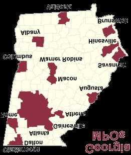

8 Georgia s MPOs Georgia s MPOs Cartersville Source:
9 Document Who Develops? Who Approves? Time/Horizon Contents Update Requirements UPWP MPO MPO 1 or 2 Years Planning Studies and Tasks Annually MTP (LRTP) MPO MPO 20 Years Future Goals, Strategies and Projects Every 5 Years (4 years for nonattainment and maintenance areas) TIP MPO MPO/Governor 4 Years Transportation Investments Every 4 Years LRSTP State DOT State DOT 20 Years Future Goals, Strategies and Projects Not specified STIP State DOT US DOT 4 Years Transportation Investments Every 4 Years
10 Local Governments Develop local transportation priorities and plans Engage in regional and state transportation planning activities Conduct studies to identify impacts of new development on the transportation system Identify and schedule improvements Maintain local streets and roads Fund transportation projects
11 Transit Agencies Operate publicly available transportation options including buses, subways, light rail, passenger rail, ferryboats, trolleys Quasi-Governmental that receive government subsidies (Federal / State / Local) in addition to generating revenue from private sources such as fares and advertising Develop system plans, implement projects and coordinate with state and local governments on regional planning activities
12 Other Agencies Community Improvement Districts (CIDs) Public-Private partnership that leverages dollars from member private entities to implement public projects With approval from local government, private commercial property owners vote to self-tax. Board of Directors makes decisions regarding projects to implement Regional Commissions (RCs) Regional planning agency providing support to local governments
13 Transportation Plans & Programs Establish vision, goals, and objectives and based on: Existing transportation needs Future transportation needs based on: Projected Population Growth Projected Economic Changes Framework from which to identify and prioritize projects (air, bicycle, bus, rail, roads, pedestrian, and water)
14 MAP -21 Federal Surface Transportation Legislation Moving Ahead for Progress in the 21st Century (MAP-21) signed July 2012 Over $105 Billion authorized for FY 2013 and FY 2014 First long-term authorization since 2005 (SAFETEA-LU) Performance-Based Planning Approach


15 MAP -21 Performance Goals MAP -21 Performance Goals MAP-21 National Performance Goals Safety Infrastructure Condition Congestion Reduction Environmental Sustainability System Reliability Reduced Project Delivery Delays Freight Movement & Economic Vitality Performance Reporting National Highway System performance and key safety issues Freight congestion Strategic investment in asset management Performance measures and targets developed as part of the State s Transportation Plan
16 Planning Process Continuing: Planning must be maintained as an ongoing activity and should address both shortterm needs and the long-term vision for the region. Cooperative: The process must involve a wide variety of interested parties through a publicparticipation process. Comprehensive: The process must cover all transportation modes and be consistent with regional and local land-use and economicdevelopment plans.
17 Planning Inputs and Tools Current Data and Data Forecasts Geographic Information Systems Travel Demand Models Microsimulation Models Stakeholder Engagement
18 Planning Considerations / Special Requirements Air Quality Plans must comply with Environmental Protection Agency (EPA) limits on emissions. Modeling used to demonstrate air quality conformity. Environmental Justice U.S. Executive Order defines environmental justice as the fair treatment and meaningful involvement of all people regardless of race, ethnicity, income, or education level in transportation decision-making.
19 Project Development Process To proceed to implementation, projects must: appear in the TIP and/or STIP w/funding source; consider citizen input; and have approval by transportation officials. Steps include: planning, environmental analysis, design, right-of-way acquisition, permitting, and construction.
20 Environmental Analysis The National Environmental Policy Act of 1969 (NEPA) enunciated for the first time a broad national policy to prevent or eliminate damage to the environment. Environmental impact analysis must be performed for any project receiving federal funds. Required to proceed with ROW acquisition and construction. All alternatives consistent with the objective of each project must be evaluated to find the best transportation solution that helps preserve and protect the value of environmental and community resources.
21 The NEPA Process Evaluation to determine project impacts to the community, the natural environment, and our health and welfare. Before any project can move advance to ROW and construction, the Federal agencies require compliance with more than 40 laws related to safety and the environment.
22 Transportation Funding 101 Federal Apportionments Highway Trust Fund State Funds General Fund State Motor Fuel Tax Bonds Local Funds Special Purpose Local Option Sales Tax (SPLOST) General Fund

23 Identifying Transportation Solutions Identifying Transportation Solutions Considerations: Considerations: Future Demand Future Demand Safety Safety Roadway Operations Roadway Operations Preservation Preservation Land Use Linkage Land Use Linkage

24 Conventional Approach Conventional Approach More Cars More Cars More Lanes More Lanes More Roads More Roads System Management System Management ITS ITS Complementary Approaches Complementary Approaches More More Paveme Paveme nt nt More Efficiency More Efficiency
25 Conventional Approach More Cars More Lanes More Roads System Management ITS omplementary Approaches Complementary Approaches Transit Bicycling Walking HOV/HOT Lanes More Paveme nt More Efficiency User View and Comfort Context-Sensitive Design Traffic Calming Personal Security Mixture of Uses Road Network Pedestrian-Oriented Compact Development Lateral Approach Manage, Not Solve Lane Limits Change Standards

26 Interstates Freeways Functional Classification Functional Classification Interstates Freeways Principal arterials Principal arterials Minor arterials Minor arterials Collector roads Collector roads Local roads Local roads Source: FHWA
27 Travel Forecasting Process Four technical phases: Collection of data counts, surveys, etc. Analysis of data - socioeconomic sources Forecasts of activity and travel future projections Evaluation of alternatives - application of tools Evaluation approaches: Demand Analysis Travel Demand Modeling Operational Analysis Microsimulation


28 Travel Forecasting: Travel Forecasting: Traditional Trip-Based Four Step Model Traditional Trip-Based Four Step Model Trip generation - estimates the number of trips generated by different types of land use Trip distribution-estimates where the generated trips will go Mode split - estimates which trips will use transit and which will use auto Trip assignment - assigns trips by each mode to the roadway network Trip generation - estimates the number of trips generated by different types of land use Trip distribution - estimates where the generated trips will go Mode split - estimates which trips will use transit and which will use auto Trip assignment - assigns trips by each mode to the roadway network
29 Travel Forecasting: Tour / Activity-Based Models Factors in how people make travel decisions: whether to travel where to travel to When to travel How to travel Person-level considerations: interactions / connections throughout the day demographics time Inputs are more complex enabled by data collection improvements

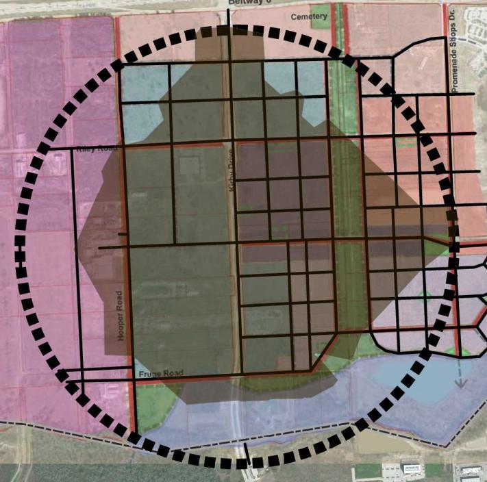
30 Sample Sample Model Model Output Output
 Volume (Average Daily Traffic) to Capacity Ratio Level of Service (LOS)")

31 Capacity Analysis Capacity Analysis Volume (Average Daily Traffic) to Capacity Ratio Level of Service (LOS) Volume (Average Daily Traffic) to Capacity Ratio Level of Service (LOS) Measure of Traffic Flow Used to Describe Operating Conditions from the Perspective of Travelers Measure of Traffic Flow Used to Describe Operating Conditions from the Perspective of Travelers

32 Balancing Transportation and Land Use Balancing Transportation and Land Use Hierarchy of facilities based on access requirements Hierarchy of facilities based on access requirements Coordinate with plans for future land use and development Coordinate with plans for future land use and development Source: FHWA
33 Traffic Impact Analysis Understanding the demands placed on the community s transportation network by new development Goals Forecast additional traffic associated with new development, based on accepted practices Determine the improvements that are necessary to accommodate the new development Assist communities in land use decision-making Consider alternative modes
34 Balancing Development Impacts Parking considerations Higher densities to support alternative modes Streetscape, building facade Bus stop and rail station design Trip capture / mixed-use development Internal site trips


35 Block Size = Walkability
36 Planning for All Users Complete Streets Variety of Modes Variety of Ages and Trip Types
37 Resources Atlanta Regional Commission Federal Highway Administration Transportation Research Board