TRAFFIC IMPACT STUDY METHODLOLGY AND GUIDELINES
|
|
|
- Allan Bradford
- 5 years ago
- Views:
Transcription


1 TRAFFIC IMPACT STUDY METHODLOLGY AND GUIDELINES Lake~Sumter Metropolitan Planning Organization
2 Table of Contents Section Page 1. Introduction 1 2. Purpose When is a TIA Required Tier 1 TIA: Projects Generating Less than 100 Peak Hour Two-way Net New Trips Tier 2 TIA: Projects Generating 100 or More Peak Hour Two-way Net New Trips TIA Requiring Regional Review Study Components Study Area Study Roadways Study Intersections Alternate Modes of Transportation Request for Exemption from doing a Tier 1 TIA Methodology Letter Report Format Detailed Descriptions of Required TIA Components Table of Contents Introduction Purpose Project Description Site Location and Site Plan Study Area/Area of Influence Planned and Programmed Improvements Committed Development Existing Roadway and Traffic Conditions Pertinent Existing Roadway Information Existing Segment Geometry Existing Intersection Geometry Existing Traffic Volumes Existing Level of Service (LOS) Future Roadway Conditions Pertinent Future Roadway Information Future Segment Geometry Future Intersection Geometry Future Traffic Conditions Background Traffic Trip Generation Trip Distribution and Assignment Future Traffic Volumes Transportation Assessment Segment Analysis Intersection Analysis Turn Lane Analysis Access Analysis i P age
3 Section Page 8.7 Mitigation Strategies Recommended Improvements Proportionate Share Calculation Summary / Conclusions Appendix Literature Review Appendix A: List of Acronyms Appendix B: Example of Request For Exemption From Doing A Traffic Impact Analysis Appendix C: Lake County Transportation Impact Fee Schedule ii P age
4 1. Introduction The Lake~Sumter Metropolitan Planning Organization (LSMPO), in coordination with the LSMPO s member governments and private sector transportation professionals, has developed a set of guidelines presented herein, for the preparation of a Traffic Impact Analysis (TIA). The intent of this document is to provide a general best practices preparation guide for applicants and/or consulting planners/engineers assessing the potential traffic impacts of new projects, updates to previously approved projects, or changes in zoning. These guidelines establish minimum standards for all TIA reports, in order to provide a clear, orderly and consistent basis on which traffic impacts are to be evaluated. NOTE: This methodology is not appropriate for a comprehensive plan amendment. Comprehensive Plan Amendments should instead follow State of Florida Department of Economic Opportunity (DEO) requirements. Available at: 2. Purpose A Traffic Impact Analysis (TIA) is an important tool in the overall development planning process. It provides information which will allow local governments to evaluate the impact of a development with respect to the need for roadway and intersection capacity, operational, and safety improvements. The purpose of the (TIA) is to identify the potential traffic impacts of a new project on the transportation system and to develop mitigation strategies to offset any impacts according to the methodologies and provisions as described herein. A TIA also evaluates the impact of a proposed project at full buildout on the multimodal transportation system, including roads, transit, bicycle, and pedestrian facilities. Another purpose of these TIA Guidelines is to provide a coordinated process for performing a review of traffic impacts created by proposed projects within the Lake~Sumter Metropolitan Planning area. The LSMPO provides planning services to its member governments that include: Lake County Town of Astatula City of Clermont City of Eustis City of Fruitland Park City of Groveland 1 P age
5 Town of Howey-in-the-Hills Town of Lady Lake City of Leesburg City of Mascotte City of Minneola Town of Montverde City of Mount Dora City of Tavares City of Umatilla Lake~Sumter MPO A TIA study assesses the effects that a particular project s traffic will have on the transportation network. Studies vary in their range of detail and complexity depending on the type, size and location of the project and can be used to help evaluate what type of transportation improvements may be necessary. Additionally, traffic impact studies are used to: Forecast additional traffic associated with a new project, based on accepted practices. Determine the improvements that are necessary to accommodate a new project. Help to ensure safe and reasonable traffic conditions on streets after a project is complete. Reduce the negative impacts due to projects by helping to ensure that the transportation network can accommodate the project. Provide direction to community decision makers and developers of expected impacts. Protect the substantial community investment in the street system. 3. When is a TIA Required A TIA must be provided in accordance with the approving jurisdictions adopted policies, plans, Land Development Regulations (LDRs) and Land Development Codes (LDCs), as otherwise required. Typically, a TIA is required at the first submission of an Overall Project Plan, or the Final Site Plan stage of the project. To determine when a TIA is required, the applicant is responsible for coordinating with the appropriate local government regarding at what project stage this should occur for their specific project. The requirements listed and applicability of this TIA shall be superseded by any future changes to Florida law. The process of a TIA begins when a land owner or designated agent proposes to make a land use change that generates vehicular trips. At that time it shall be necessary for them to coordinate with the appropriate local government agency and submit a preliminary development plan. The amount of traffic generated by a proposed project shall be calculated using the methodology and guidelines of the latest edition of the Institute of Transportation Engineers 2 P age
6 (ITE), Trip Generation Manual (currently the 9th Edition as of the writing of this document). As stated above, a TIA is required for all aspects of site development and impact assessment within the local government s jurisdiction. This includes, but is not limited to, updates to previously approved developments, the development of the Local Government Comprehensive Plan (LGCP), LGCP amendments, and particularly to Future Land Use Map (FLUM) changes. This also includes changes in zoning, reviews of Planned Unit Developments (PUDs), subdivision ordinances and related land activities. In addition, a TIA shall be required for all updates or phases of a project/development. As mentioned above a TIA may also be required for requests for rezoning prior to the project TIA to analyze the net trip difference between the current and proposed zoning categories rather than the impact of a specific proposed project. The need for a TIA or any other studies needed for a rezoning should be coordinated with the appropriate government agency (municipality or County). The determination of the TIA study type, and thus the level of detail and area of impact, required in the TIA document is dependent on the number of net new peak hour vehicular trips. Net new peak hour vehicular trips are defined as those trips produced by the project that have been adjusted for percentages of internal capture and/or pass-by trips (if applicable). Percentages of internal capture and pass-by trips must be shown to be justifiable and agreed to by the local government agency. The development s net average weekday two-way volume generation with respect to the service capacity and operating condition of the adjacent major roadway network link[s] may be also be considered. The request for this information is at the discretion of the local government agency. LOS standards and concurrency (if applicable) are determined by the local jurisdiction on state and county roads per s (5)(a), Florida Statutes (FS). Roadway segments evaluated in the TIA can be found in the LSMPO s TMS database. Under certain circumstances, additional roadway segments may be requested to be analyzed if the proposed project affects local problem areas, e.g., high accident locations, currently congested areas or areas of critical local concern. There are two (2) tiers of TIA studies, each Tier is based upon the number of net new vehicular weekday AM peak hour, weekday PM peak hour or weekend peak hour trips are generated by the project. See sections 3.1 for Tier 1 criteria and Section 3.2 for Tier 2 criteria. If the need for a Tier 1 or Tier 2 TIA is determined, both the methodology letter and the TIA must be sealed 3 P age
7 and signed by a licensed professional engineer prior to submittal. 3.1 Tier 1 TIA: Projects Generating Less than 100 Peak Hour Two-way Net New Trips De minimis Determination (Tier 1 TIA) - The LSMPO defines de minimis development as any development for which the net average weekday peak hour two-way volume generated by the development is less than 100 trip ends or driveway volume on the adjacent roadway[s]. As an example, developments of the following size typically generate less than 100 net new peak hour trips: Single Family Residential (ITE Code 210) 99 dwelling units. Apartment (ITE Code 220) 160 dwelling units. Office Building (ITE Code 710) 66,000 square feet. Retail (ITE Code 820, Shopping Center w/o supermarket) 26,000 square feet. Services (ITE Code 945, Gas station with Convenience Market) 6 Fueling Positions. Projects generating less than 100 peak hour two-way net new trips may generally be considered to create non-substantial impacts. In most cases, a Request for Exemption Letter from a Tier 1 TIA may be submitted. If the traffic impacts of a proposed project can be clearly determined to have de minimis impacts and all the parties involved (local government, LSMPO, Florida Department of Transportation (FDOT), applicant, etc.) are in agreement, the submittal of a Tier 1 TIA may not be necessary. The applicant may submit a Request for Exemption Letter from doing a TIA. The required information needed to be provided in the Exemption Letter is described in Section 5. An example of a Request for Exemption Letter from doing a TIA can be found in Appendix B. Any exemptions to performing a Tier 1 TIA or deviation from this methodology shall be at the discretion of the appropriate local government. If an exemption is approved, the local government has the responsibility of notifying the LSMPO. However, there may be circumstances when a project generates less than 100 Peak Hour Twoway Net New Trips and the Request for Exemption Letter is denied. At this point a Tier 1 TIA is necessary. The applicant will need to submit a Methodology Letter for approval prior to the Tier 1 TIA submittal. The required information to be contained in the Methodology Letter is described in section 6. If any deviations from, or modifications to a Methodology are considered by the local government, the LSMPO must be notified prior to the submittal of the methodology by the applicant. 4 P age
8 The required information to be included in the Tier 1 TIA document are described in general in Section 4 and detailed in Section 7 and Section Tier 2 TIA: Projects Generating 100 or More Peak Hour Two-way Net New Trips A Tier 2 TIA is required whenever a project is expected to generate 100 or more peak hour twoway net new trips. For projects generating 100 or more peak-hour net new trips, a detailed TIA is required. Prior to the submittal of the study, a Methodology Letter must be submitted and approved by the LSMPO and/or the local government agency. All components of the Methodology Letter are described in detail in Section 6 of this methodology document. All components of the TIA are described in general in Section 4 and detailed in Section 7 and Section 8 of this methodology document. Projects that impact state facilities (state roads) will need to have the TIA reviewed by the Florida Department of Transportation (FDOT) District TIA Requiring Regional Review Projects that generate 5,000 or more Average Daily Traffic (ADT) will require regional coordination that may include other cities, counties and FDOT as reviewing agencies. Projects of this size will typically have a wide study radius that may affect not just the local municipality but have regional affects and may cross county lines. These details shall be addressed in a methodology meeting. 4. Study Components The study components will be discussed during the methodology review process, but ultimately, it is at the discretion of the local government to reduce or expand the study area; add additional roadway segments and intersections as deemed necessary; show the effects of the project on and provision of intermodal facilities; and request supplementary information that is not specifically stated in the TIA methodology as written herein. 4.1 Study Area For a Tier 1 TIA the study area shall be defined as having a minimum 1 mile radius from the main access point of the proposed project. A Tier 2 TIA will have a study area of a minimum 1 mile radius plus all roadways where the project s peak hour trips consume five percent (5%) or more of a roadway s two-way peak hour generalized service volume based on the adopted LOS and committed number of lanes, unless otherwise specified by the City/County. 4.2 Study Roadways The study roadways will include all local roadway[s] where the project has access onto the 5 P age
9 roadway network. Including all arterials, collector roadways, and state roadways that are within a minimum of a one (1) mile radius of main access point of the proposed project for analysis. All roadway links to the point where the project s peak hour trips consume less than 5% of the roadway s two-way peak hour generalized service volume based on the adopted Level of Service (LOS) and committed number of lanes, unless otherwise specified by the City/County. The committed number of lanes shall be the existing lanes plus any improvements that are funded for construction within the first three (3) years of the Transportation Improvement Program (TIP) or funded local projects not in the TIP. It is at the discretion of the local government to reduce or expand the list of study roadways required for the study. 4.3 Study Intersections All project access points onto the local roadway network. All signalized intersections that are within a minimum of a one (1) mile radius of main access point of the proposed project shall be analyzed. Un-signalized intersections within a one (1) mile radius of main access point that are significantly impacted by project traffic shall also be analyzed. All access points to the sites shall also be analyzed. It is at the discretion of the local government to reduce or expand the list of study intersections required for the study. 4.4 Alternate Modes of Transportation Impacts to the existing or future funded transit network and transit amenity infrastructure (as per the adopted Transit Development Plan) on road segments within the TIA analysis area and roadway segments within the Americans with Disabilities Act (ADA) complementary paratransit service area for the transit system must be assessed as part of the TIA. Existing, planned or proposed bicycle facilities, pedestrian facilities and multiuse trails within the study area of the proposed project shall be analyzed to ensure the proposed project will maintain or improve existing conditions for pedestrians and bicyclists. Special attention should be directed toward multimodal improvements within the walk zone for all schools within the TIA analysis area of the proposed project. 5. Request for Exemption from a Tier 1 TIA As defined in Section 3.1, projects that generate less than 100 peak hour two-way net new trips are eligible to submit a Request for Exemption Letter from a Tier 1 TIA. If a project meets the criteria and the applicant decides to submit a Request for Exemption Letter from a Tier 1 TIA, the following information, at a minimum, must be provided: Purpose (to include the grounds for the exemption). Project Description Site Location Map 6 P age
10 Site Plan Trip Generation Calculation (include land use description, ITE Code number, number of units, rate/formula for Daily and PM Peak trip generation, daily and PM Peak trips with in/out trips. Area of Influence/Study Area Trip Distribution/Assignment. Details regarding the requirements for bulleted items listed above are provided in Section Methodology Letter Prior to conducting the TIA, a written methodology letter shall be prepared by the applicant and submitted for review and approval by the local government. The purpose of the methodology letter is to establish agreed upon methodologies and assumptions prior to the start of the study, corresponding to the issues outlined in the following sections. The Methodology Letter, prior to the submittal of a TIA, must include: Project description and purpose. Level of TIA being presented (Tier 1 or Tier 2). Site Location map. Map of the area of influence/study area. Site plan of the proposed development that shows the proposed access locations. Summary of the proposed trip generation including any proposed pass-by trips and internal trip capture. Show all input items (i.e. Land Use description, ITE Codes, trip rates or formulas) and data used in the calculations. Proposed trip distribution (to a minimum of 1 mile from the access point[s]) in the study area, and include backup calculations. List of roadways from the LSMPO Transportation Management System (TMS) database that fall within the study area. Identify any critical issues related to the project. Proposed growth rate for calculation of future traffic (if project is phased or anticipated to take more than one year to complete). Date of any traffic counts used in the analysis. List of all signalized intersections and major un-signalized intersections that fall within the study area or are recommended to be included in the study. Once approved, the methodology letter shall be valid to govern submittal of the TIA for a period of six (6) months. It shall be the Applicant s responsibility to ensure that a traffic study is not prepared or submitted without an approved Methodology Statement signed by the Local Government. As mentioned in Section 3 the Methodology Letter must be sealed and signed by 7 P age
11 a licensed professional engineer. Lake~Sumter MPO 7. Report Format To provide consistency and facilitate review of the TIA, the following outline shall be followed to the extent possible: Table of Contents List of Figures List of Tables Introduction - to include o Purpose of the project o Project Description o Site Location o Site Plan o Study Area/Area of Influence o Planned and Programmed Improvements o Committed Development in the area Existing Roadway and Traffic Conditions o Pertinent existing roadway information o Existing roadway segment geometry o Existing intersection geometry o Existing traffic volumes o Existing LOS Future Roadway and Intersection Conditions o Pertinent Future Roadway Information o Future Roadway Segment Geometry o Future Intersection Geometry Future Traffic Conditions (if appropriate) o Background Traffic o Trip Generation o Trip Distribution and Assignment o Future Traffic Volumes Transportation Assessment o Segment Analysis o Intersection Analysis o Turn Lane Analysis o Access Analysis Multimodal Assessment o Transit o Bicycle o Pedestrian Mitigation Strategies o Recommended Improvements o Proportionate Share Calculations 8 P age
12 Summary/Conclusions o Brief discussion to highlight the reason for the TIA Tier classification o Methodology Followed o General Results of the Analysis o Action Requested (e.g., approval of mitigation strategy) of the local government Appendix o Traffic Count Data (if applicable) Average Daily 24-Hour or Peak Hour Traffic Counts Peak-Hour Turning Movement Counts (AM, PM, Mid-day, Weekend (as applicable) o Capacity Analysis Summary Sheets Existing Conditions Future Conditions Future Mitigated Conditions (per Phase, if required) o Trip Distribution Plot from the Travel Demand Model Be sure to include North Arrow Title of Plot (describe the data that is shown; e.g. PM Peak, with project trips, etc.) Site Location Road Names (Major Roads and the roads where the project has access points) 8.0 Detailed Descriptions of Required TIA Components The following section describes the minimum content/information that shall be included in each chapter or section of the TIA based on the outline provided in Section Table of Contents Sections by number with title and page number List of Tables by number with title and page number List of Figures by number with title and page number 8.2 Introduction This sections shall contain pertinent information about the proposed project. The information shall be provided as discussed below Purpose The reason for the submittal of the TIA (Tier 1, Tier 2, or Regional Reviews) shall be stated. For example, it shall be stated if the TIA is being submitted for a development plan approval, zoning change, etc. Another example would be if the TIA is being submitted as an update to a previously approved development/ phase. 9 P age
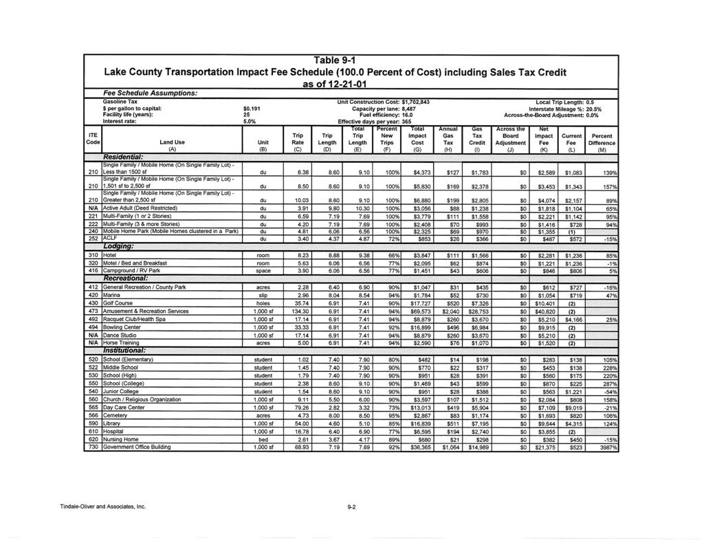
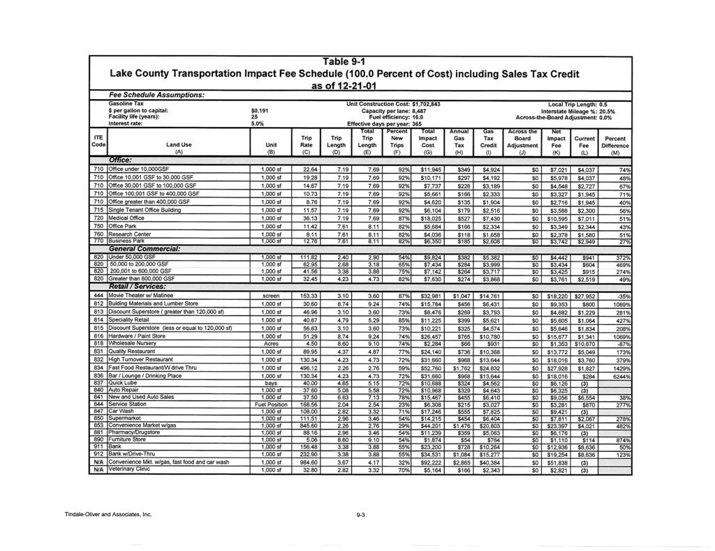
13 8.2.2 Project Description A brief description of the proposed project shall be provided. The following information shall be provided and can be presented as a bulleted list or table: Area Type (Rural, Transitional, Urban) Type of Development (e.g., Residential, Retail, etc.) Edition of the Institute of Transportation Engineers (ITE) used, Land Use Code(s) Size of development in standard ITE units (e.g., dwelling units for residential, 1,000 square feet for commercial/retail, etc.) Location/Description of the proposed development site and access points Anticipated opening/buildout year (by phase, if necessary) Analysis years (by phase, if necessary) Analysis periods (e.g., AM, PM, Mid-day, etc.) Source of adopted roadway Level of Service (refer to TCMS spreadsheet) Site Location and Site Plan An area Figure/Map shall be provided to show the location of the project in relation to the surrounding region. This figure shall show the area of influence of the project, as discussed in the following section. In addition, a site plan shall be included in this section to provide an overview of the project site and site access Study Area/Area of Influence The study area to be addressed by the applicant shall be regional in nature and shall include all roadways and major intersections affected by the proposed development. For those projects requiring a Methodology Letter, the study area will be defined prior to submittal of the TIA. The applicant should request the local government/lsmpo provide the study area based on location and proposed land use (provided by applicant). The extent of the study impact area shall be determined by the area of influence of the project. The area of influence shall be established as one-half (1/2) the total trip length associated with the land use of the proposed development, based upon the Lake County Transportation Impact Fee Update Study Final Report (see table in Appendix C, column D ). The area of influence shall be based on the as the bird flies distance. The roadway segments and intersections within the area of influence shall be considered for further study. In cases where the proposed project involves multiple land uses, the study area shall be defined as one-half 10 P age
14 the total trip length associated with the land use having the longest total trip length. It should be noted that once the study area has been established based on the previously described methodology, there is the potential that not all intersections and segments within the study area will require full analysis. The intersections requiring full data collection and analysis will be determined by the anticipated effect of the proposed development at each location. The principal factors in this determination include the project trip distribution on the study area network and existing LOS and operations on the study area roadways and at the subject intersections. As the effect of the project traffic on more distant segments and intersections diminishes, specific locations may be removed from further consideration. Additionally, factors that could also influence the area of influence are the existing and future land uses in the area, and the existing and future transportation network. The study area roadways and intersections may be discussed during the methodology review process, but ultimately, it is at the discretion of the local government to reduce or expand the study area, as deemed necessary Planned and Programmed Improvements This section shall identify and discuss all planned and programmed roadway improvements relevant to the study area. This includes all local, state and federal projects that have been planned or funded. The section shall include a list of planned or programmed improvements, location/limits, programmed phases with years, and the name of the agency responsible for implementing the project. Only those programmed improvements contained in the first three (3) years of the relevant work program, and funded for construction, shall be considered as capacity in-place. If no programmed or planned improvements are relevant to the study area, the applicant shall indicate that there are no planned or programmed improvements within the project study area within the next three years. In general, both the Lake County and Sumter County TCMS will be kept up to date with planned and programmed improvements from the first three years of the work program Committed Development This section shall include discussion and figures pertaining to 11 P age
15 Approved/Committed Development. In general, the Lake County and Sumter County TCMS will be kept updated with committed/reserved trips relevant to the study area. If no information is available then an appropriate growth rate, as approved by the local government, shall be used. 8.3 Existing Roadway and Traffic Conditions The applicant is responsible for collecting or obtaining the existing conditions data required to effectively produce a TIA that meets the local government s requirements. The existing conditions data will include information on existing roadway geometry, existing traffic control, existing traffic volumes and existing LOS. This information shall be from field observations and the Lake County or Sumter County TCMS spreadsheet and may be presented collectively using tables and/or figures Pertinent Existing Roadway Information Any information that does not fall strictly into the existing segment and intersection categories shall be documented. This may include discussion and figures pertaining to Access Management (e.g., restricted, unrestricted), Functional Classification (e.g., arterial, collector, local road), Area Type (e.g., urban, urban transitioning, or rural/undeveloped), etc Existing Segment Geometry Information shall be provided about the existing geometry or laneage of the study segments. Typically this information is depicted in a figure or listed in a table Existing Intersection Geometry Information shall be provided about the existing geometry or laneage of the study intersections. Typically this information is depicted in a figure or listed in a table Existing Traffic Volumes A discussion and appropriate Tables/Figures shall be provided to present existing year Average Daily Traffic (ADT) and peak-hour directional volumes on study area roadway segments, and existing year peak-hour Turning Movement Counts (TMCs) at the study area intersections. P.M. peak-hour directional volumes are provided in the Lake County or Sumter County TCMS spreadsheet, provided at or before methodology. In cases where 12 P age
16 no information exists in the TCMS for a particular segment (zeroes in the TCMS or there are no traffic counts on the roadway segment being analyzed), manual/tube counts shall be required. For such a situation, count data from the most recent FDOT Traffic Information DVD and/or the Lake County and Sumter County Annual Traffic Count programs may also be utilized to obtain segment volumes. Historical TMC data collected by others that is less than one (1) year old may also be utilized with prior local government approval, provided that the counts are grown to present day volumes using an accepted growth rate Existing Level of Service (LOS) Existing LOS analyses shall be conducted for segments and intersections based on currently accepted traffic engineering principles. Methods that incorporate and apply appropriate techniques from the latest edition of the Highway Capacity Manual (HCM) are acceptable. These methods may include the use of the latest available versions of the Highway Capacity Software (HCS), Synchro, LOSPLAN and the FDOT Generalized Service Volume tables. The existing LOS shall be compared to the adopted LOS standards used for concurrency determination and shall be consistent with the Transportation Element of the local government s Comprehensive Plan. The LOS standards for an intersection analysis shall be the conservative adopted roadway LOS standard of the intersecting roadways. For the majority of facilities, the Lake County and Sumter County TCMS may be used (if up to date) for the adopted LOS standards, area type, facility type, maximum service volume, etc. as they apply to the transportation network. If the TCMS is not currently up to date, use the Transportation Element of the local government s Comprehensive Plan. When an applicant is utilizing the FDOT Generalized Service Volume tables, particular attention shall be given to the appropriate selection of criteria based on Access Management (e.g., restricted, unrestricted), Functional Classification (e.g., arterial, collector, local road), Area Type (e.g., urban, urban transitioning, or rural/undeveloped), etc. Before conducting an analysis utilizing LOSPLAN, the applicant shall verify with the Lake County or Sumter County TCMS that an analysis on the affected segments has not already been developed, and is being applied in the TCMS, 13 P age
17 within the past year. If an approved LOSPLAN analysis, less than one (1) year old, exists within the Lake County or Sumter County TCMS, the applicant shall utilize these results for the applicable segments of the system within the study area Future Roadway Conditions This section shall contain information pertaining to the future (build-out year) roadway conditions. Generally, if the future roadway conditions are not substantially different from the existing year (as would be the case when there are no pertinent planned and programmed improvements) then this section may not be necessary and a brief statement to that effect shall be provided Pertinent Future Roadway Information Any information that does not fall strictly into the existing segment and intersection categories shall be documented. This may include discussion and figures pertaining to Access Management (e.g., restricted, unrestricted), Functional Classification (e.g., arterial, collector, local road), Area Type (e.g., urban, urban transitioning, or rural/undeveloped), etc. If the pertinent roadway information does not differ from that of the existing conditions, then this may be stated in lieu of tables or figures Future Segment Geometry This section shall include information about the future geometry or laneage of the study segments. Typically this information can be depicted in a figure or listed in a table. If the future segment geometry does not differ from the existing segment geometry, then this may be stated in lieu of tables or figures Future Intersection Geometry This section shall include information about the future geometry or laneage of the study intersections. Typically this information can be depicted in a figure or listed in a table. If the future intersection geometry does not differ from the existing intersection geometry, then this information may be stated in lieu of any tables or figures Future Traffic Conditions The applicant shall provide a graphical summary or table of the future year background traffic, plus the proposed development traffic for the A.M. peak-hour, P.M. peak-hour, 14 P age
18 Mid-day peak-hour or weekend peak-hour (whichever is applicable). These volumes shall include both segment and turning movements within the study area. Note that de minimis impacts are defined by Florida Statute as project impacts equating to less than 1% of the maximum service volume for the impacted roadway segment. Cumulative de minimis impacts may not exceed 110% of the maximum service volume for non-hurricane evacuation routes or 100% of the maximum service volume for designated hurricane evacuation routes Background Traffic Background (committed/reserved) traffic from approved developments in the area shall be tracked and is maintained within the Lake County and Sumter County TCMS. As such, in most cases, a separate determination of background traffic will not be required. However, should the Lake County or Sumter County TCMS not be up to date, a previously agreed upon growth rate from the Methodology will be used Trip Generation Trip generation involves estimating the number of trips that will be produced from or attracted to the proposed development. The latest edition of the ITE Trip Generation manual (currently the 9th Edition, as of the writing of this document) shall be used to determine proposed project trip estimates. The estimates obtained from this source must be used with good judgment as they are based on national data and may not take into account any special features that the local subject site might have. Opportunities are available for reducing the estimated trips to derive net, new, external trips and include: INTERNAL CAPTURE Internal capture refers to the percentage of trips generated by a multiple land use development (e.g., having a combination of retail, office and/or residential uses) that take place entirely within that development. Deductions may be made to the total site-generated trip estimates of a multi-use development by estimating the amount of internal capture for individual land uses. The ITE Trip Generation Handbook contains the recommended procedure for estimating internal capture deductions. 15 P age
19 Provide any internal capture worksheets in the appendix. PASS-BY TRIPS Retail land uses experience pass-by trip "capture" from the adjacent traffic stream. Pass-by trips are those already on the network making intermediate stops en-route between an origin and a primary trip destination, without route diversion. These trips shall not be included in the new trip estimates. In general, pass-by trips should not exceed 10% of the background traffic on the adjacent roadway, nor 25% of total trip generation. However, fast-food restaurants, gas stations/convenience stores, pharmacies/drug stores and drive-in banks, due to their high passby nature, may exceed 25% of the total, with permission from the local government. New trip percentages, by land use, are provided in the Lake County Transportation Impact Fee Update Study Final Report (see table in Appendix C, column F ). Should this document not be current, the use of the ITE Handbook is acceptable. If the ITE Handbook is used, the pertinent data used needs to be described in the text and included in the appendix. The use of internal capture and pass-by rates shall be approved at the discretion of the local government Trip Distribution and Assignment Trip distribution is a process by which the trips generated in one traffic analysis zone (TAZ), or by one land use, are allocated to other TAZs, or other land uses, in the study area. Trip assignment is the process of numerically assigning the distributed trips to specific transportation facilities. The term trip distribution is sometimes used to define both procedures of trip distribution and assignment. Trip distribution and assignment may be based on the Lake~Sumter MPO s currently adopted travel demand model (presently the Central Florida Regional Planning Model [CFRPM]), market analysis, existing traffic flows, applied census data, or professional judgment (manually distributed). In general, this section shall present the forecasted trip assignment based on the development s trip generation and distribution estimates. This typically takes the form of figures providing the percentage of total proposed project trips on the individual roadways in the transportation study network. The procedures and logic for estimating the trip distributions must be well documented. The trip distribution 16 P age
20 and assignment patterns shall be presented for each phase of the development or as requested by the local government. Unless otherwise agreed at Methodology, proposed projects which are projected to generate one-hundred and one (101) or more net new peak-hour project trips (Tier 2 TIA) should utilize the Lake~Sumter MPO s currently adopted travel demand model (presently CFRPM) to derive trip assignment percentages Future Traffic Volumes This section shall include discussion and figures presenting future year AADT on study roadway segments and future year peak-hour TMCs at the study intersections. Typically, this information can be depicted in a figure or listed in a table. This estimate of future year traffic volumes on the study area transportation network would result from the summation of the proposed project volumes, determined after the processes of trip generation (including adjustment for internal capture and pass-by trips), trip distribution and assignment, committed/reserved trips from the Lake County and Sumter County TCMS or applied growth rate, and existing traffic volumes. Committed/ Future Traffic = Existing Traffic + Reserved Trips from TCMS OR + Project Traffic Volumes Volumes Multiply by Growth Rate 8.6. Transportation Assessment LOS analyses shall be conducted and utilize the future and projected traffic volumes, as obtained following the guidance provided in Section 8.5. The analysis shall be based on currently accepted traffic engineering principles. Methods that incorporate and apply appropriate techniques from the latest edition of the Highway Capacity Manual are acceptable. These methods may include the use of HCS, Synchro 6 and higher, LOSPLAN and FDOT Generalized Service Volume tables. The LOS standards used for concurrency determination shall be consistent with the Transportation Element of the local government s Comprehensive Plan. The LOS standards for an intersection shall be the most conservative adopted roadway LOS 17 P age
21 standard of the intersecting roadways. For the majority of facilities, the Lake County and Sumter County TCMS will be kept up to date with the adopted LOS standards, area types, facility types, maximum service volumes, etc., as they apply to the transportation network. If the TCMS is not currently up to date, use the information in the Transportation Element of the local government s Comprehensive Plan Segment Analysis A roadway segment analysis shall be performed on each of the study roadway segments. If the analysis indicates that the future segment LOS will be below the adopted LOS standard, potential mitigation measures shall be developed and analyzed to show effectiveness of the improvement(s), as well as a fair share calculation for these measures. The latest version of LOSPLAN can also be used to develop an alternative capacity/service volume based on corridor-specific data. The LOSPLAN analyses must be approved by the local government and shall be applied in the TCMS as the new capacity Intersection Analysis A signalized or un-signalized intersection analysis shall be performed on each of the study intersections. The procedure shall utilize Highway Capacity Manual techniques, as previously mentioned in Section 8.6. The existing LOS shall be compared to the adopted LOS standards, used for concurrency determination, and shall be consistent with the Transportation Element of the local government s Comprehensive Plan. The LOS standards for an intersection shall be the most conservative adopted roadway LOS standard of the intersecting roadways. A summary of the analysis results shall be tabulated with the software output included in the Appendix section. If the analysis determines that the future intersection LOS will be below the adopted LOS standard, potential mitigation measures shall be developed and analyzed to show effectiveness of the improvement(s), as well as the fair share calculation for these measures Turn Lane Analysis For intersections with failing turning movements, the need for additional turn lanes and an analysis of turn lane storage length adequacy shall be conducted. Information regarding the methodologies to conduct this analysis is available in References 21, 22 and P age
22 Access Analysis The TIA shall include an assessment of on-site and off-site turn lane adequacy, required storage, potential for signalization, sight distance and other intersection safety aspects, and on-site circulation as it may affect access. Use of joint access driveways is encouraged to reduce the total number of connections to the roadway network. The following points should be considered in determining the need for turn lanes: The total traffic generated by the anticipated traffic distribution, the number of access points and the projected turning movement volumes. A traffic analysis indicates that turn lanes would be necessary to maintain capacity on fronting roads and/or at adjacent or nearby intersections. Entrances are proposed at locations where grade, topography, site distance, traffic, or other unusual conditions indicate that turn lanes would be needed to improve safety. Land development regulations will govern when access to the County Road network is involved. Lake County typically requires turn lanes projects generating 50+ peak hour trips. For access to the State Highway System, normal procedures with FDOT apply. 8.7 Mitigation Strategies If the transportation assessment reveals that the potential project will not result in a deficiency in the existing roadway network then no project-related improvements are required. However, mitigation strategies must be developed if the transportation assessment determines that the proposed project will potentially result in a deficiency in the LOS of transportation facilities. This process involves addressing the extent of the mitigation strategies/solutions as well as calculation of fair share cost Recommended Improvements Mitigation strategies must be developed if the transportation assessment determines that the proposed project will potentially result in a deficiency in the Level of Service of transportation facilities. Mitigation measures for segments, intersections, turn lanes and site access shall be developed to allow the build condition to operate above the local government s acceptable Level of Service 19 P age
23 standards. These measures may include, but are not necessarily limited to: Revised striping Addition of turn lanes Addition of travel lanes Addition of storage lanes Lengthening of storage lanes Installation of traffic signals Installation of traffic control signs Restriction of turning movements Adjustment of traffic signal cycle lengths Introduction of additional traffic signal phases Improvements must be concurrent with the impacts of development. Concurrency is a state requirement that development is not to proceed unless infrastructure capacity and specific urban services are in place to service the new development. If reasonable mitigation measures cannot be implemented to assure that traffic will operate in an efficient way, a more detailed evaluation of project size, land use types, and development phasing may be required. If viable transportation improvements cannot be recommended, then steps must be taken to reduce the project s impact on the adjacent roadway network to acceptable levels Proportionate Share Calculation The intent of the proportionate share option is to provide applicants an opportunity to proceed under certain conditions, notwithstanding the failure of transportation concurrency, by contributing their share of the cost of improving the impacted transportation facility. However, the ability of local governments to fund improvements is subject to budget constraints. Consequently, it should be noted that the determination of a project s proportionate share cost and the applicant s ability to pay that cost is not a guarantee the project will be approved. In addition, there is no guarantee of a funding match by the local government to facilitate implementation of the proposed mitigation strategy unless it is formalized in an agreement. The estimated cost of the needed intersection and roadway improvements shall be calculated for the stage or phase of the project under review using guidance 20 P age
24 provided in FS (16) and FAC 9J The formula below is provided as guidance: Proportionate Cost of Increase in Share Cost = Improvement * Project Trips Service Volume where, Increase in Service Volume is the change in peak-hour maximum service volume of the roadway that would result from the construction of the improvement necessary to maintain the adopted LOS. Cost of Improvement is the cost of construction, at the time of developer payment, of an improvement necessary to maintain the adopted level of service. Construction cost includes all improvement associated costs, including engineering design, right-of-way acquisition, planning, engineering, inspection, and other associated physical development costs directly required and associated with the construction of the improvement, as determined by the governmental agency having maintenance authority over the roadway. Project Trips are the trips from the stage or phase of the project under review that are assigned to a roadway segment and have triggered a deficiency based upon comparison to the adopted LOS. 8.8 Summary/Conclusions A brief discussion (one or two paragraphs) shall be provided to highlight the TIA Tier classification (Tier 1, Tier 2, or Regional Review), methodology followed and general results including any deficiencies and mitigation. In addition any action requested (e.g., approval of mitigation strategy) of local government shall be specified. 8.9 Appendix A. Traffic Count Data i. Average Daily 24-Hour Traffic Volumes (as necessary) ii. Peak-hour Turning Movement Volumes (A.M./P.M./Mid-day, as necessary) B. Capacity Analysis Summary Sheets i. Existing Conditions ii. Future Conditions (per phase if required) 21 P age
25 iii. Future Mitigated Condition (per phase if required) C. Lake County TCMS spreadsheet (relevant sections) 9. Literature Review 1. City of American Canyon, California. (2006). Draft Impact Traffic Study Guidelines. 2. Bedford County, Virginia. (2004). Traffic Impact Study Guidelines. 3. Hendry County, Florida. (2004). Traffic Impact Study Guidelines and Procedures. 4. Indiana Dept. of Transportation. (1993). Applicant s Guide to Traffic Impact Studies. 5. City of Lexington, South Carolina. (1999). Traffic Impact Study Guidelines. 6. Missouri Dept. of Transportation. (2006). Traffic Impact Study Guidelines. 7. North Carolina Dept. of Transportation. (2003). Traffic Impact Study Guidelines. 8. City of Sedro-Woolley, Washington. (2005). Traffic Impact Study Guidelines. 9. City of Winter Garden, Florida. (2006). Traffic Impact Analysis Requirements. 10. California Dept. of Transportation. (2002). Guide for the Preparation of Traffic Impact Studies. 11. City of Pasadena, California. (1999). Traffic Impact Report Preparation Guidelines. 12. Harris County, Texas. (2002). Traffic Impact Analysis Guidelines. 13. City of Chapel Hill, North Carolina. (2001). Guidelines for Traffic Impact Analysis. 14. City of Berkeley, California. (2005). Guidelines for Development of Traffic Impact Reports. 15. Citrus County, Florida. (2000). Traffic Impact Guidelines. 16. Riverside County, California. (2005). Traffic Impact Analysis Preparation Guide. 17. Florida Dept. of Transportation. (1997). Site Impact Handbook. 18. Institute of Transportation Engineers. (2003). Trip Generation. (9th ed.) Washington, D.C.: Institute of Transportation Engineers. 19. Garber, J. N. & Hoel, A. L. (1988). Traffic and Highway Engineering. St. Paul: West Publishing Company. 20. Mcshane, R, W., Prassas, S. E., Roess, P. R. (2004). Traffic Engineering. (3rd ed.) Upper Saddle River: Pearson Prentice Hall. 21. Florida Dept. of Transportation. (2006). Roadway and Traffic Design Standards. 22. Florida Dept. of Transportation. (2006). Plans Preparation Manual - Volume National Cooperative Highway Research Program. (2001). NCHRP Report 457 -Evaluating Intersection Improvements: An Engineering Study Guide, Washington D.C.: National Academy Press. 22 P age
26 24. Florida Dept. of Transportation. (2006). Model Ordinance for Proportionate Fair-Share Mitigation of Development Impacts On Transportation Corridors. 25. Florida Legislature. (2008). The 2007 Florida Statutes Florida Administrative Weekly & Florida Administrative Code. (2008). Transportation Uniform Standard Rule Florida Dept. of Transportation. (2007) LOS Issue Papers. 28. Sumter County. Guidelines for Traffic Impact Analysis (TIA) (2007) 29. City of Wildwood. Concurrency Management System (2007). 30. River to Sea TPO (2016). Transportation Impact Anaysis (TIA) Guidelines. 23 P age
27 ADA ADT AADT CDA Lake~Sumter MPO Americans with Disabilities Act Average Daily Traffic Average Annual Daily Traffic Appendix A List of Acronyms Campus Development Agreement CFRPM Central Florida Regional Planning Model CMP CMS DRI DVD FDOT FLUM FQD HCM HCS ITE LDC LDR LGCP LOS Congestion Management Plan Congestion Management System Development of Regional Impact Digital Video Disc Florida Department of Transportation Future Land Use Map Florida Quality Development Highway Capacity Manual Highway Capacity Software Institute of Transportation Engineers Land Development Code Land Development Regulations Local Government Comprehensive Plan Level of Service LSMPO Lake~Sumter Metropolitan Planning Organization MPO PDF PUD TAZ TCMS TIA TIP TMC Metropolitan Planning Organization Portable Document Format Planned Unit Development Traffic Analysis Zone Transportation Concurrency Management System Traffic Impact Analysis Transportation Improvement Plan Turning Movement Count 24 P age
28 APPENDIX B Example: Request For Exemption From Doing A Traffic Impact Analysis 25 P age
29 Teague Plaza Request for Exemption From Doing a Tier 1 Traffic Impact Analysis The purpose of this evaluation is to provide a traffic analysis for the proposed Teague Plaza site. The project is located on the west side of CR 25 north of Griffin Avenue in the Town of Lady Lake. The proposed facility will have 6,400 SF of commercial/retail uses with six apartment units. The existing land use is vacant property. TRIP GENERATION RATES The number of vehicle trips that will originate from, or are destined to, a development is dependent upon the type and amount of land uses contained within that development. Trip rates used in this analysis are from the ITE publication, Trip Generation, 9 th Edition. Table 1 below summarizes the land use types, land use codes and trip rates for the development. LAND USE LUC Table 1 - ITE Trip Rates UNIT RATE PM PEAK HOUR EQUATION Apartment 220 Trips/Dwelling Units Average Rate = % 35% Specialty Retail Center 826 Trips/1,000 SF GFA Average Rate = % 56% % In % Out TRIP GENERATION - EXISTING The existing condition of the proposed site is a vacant field. There is currently no trip generation associated with the existing use. Accordingly, existing traffic volumes are zero. TRIP GENERATION - PROPOSED Once trip generation rates are established, trip generation volumes can be calculated based upon the size and extent of the development. Table 2 summarizes the trip generation for the proposed project. Table 2 - Trip Generation Volumes (Proposed) PM PK HR LAND USE AMOUNT Vol. In Out Apartment 6 Dwelling Units Specialty Retail Center 6,400 SF of GFA TOTAL In order to determine the net effect of the site on the road system, the trip generation volumes need to be adjusted to consider the effects of internal capture and pass-by
30 Teague Plaza Request for Exemption From Doing a Tier 1 Traffic Impact Analysis Page 2 of 2 trips. Internal capture is the portion of the total number of trips that are contained within the site. Pass-by trips are the portion of the total number of trips that are intermediate stops on the way from an origin to a destination, neither of which are the project. The number of internal capture and pass-by trips are subtracted from the trip generation volumes to determine the adjusted volume of project traffic that impacts the road system. For this evaluation the percentage of internal capture is zero. The percentage of pass-by trips is taken from the adopted Lake County Impact Fee Schedule. Table 3 summarizes the adjusted trip generation for the project. Table 3 - Adjusted Trip Generation Volumes (Proposed) TRIP GEN % PASSBY ADJ PM VOL LAND USE VOL IN VOLUME PASSBY VOLUME PK VOL OUT Apartment Specialty Retail Center 17 15% TOTAL NET NEW TRIPS Net new trips are determined by calculating the difference in the adjusted trip volumes between the existing and the proposed uses. Table 4 summarizes the estimated trip generation net increase (or decrease) due to the proposed development. Table 4 - Net New Trips PM PEAK HOUR CONDITION Vol. In Out Existing Proposed Net New Trips Request for Exemption From Doing a Tier 1 Traffic Impact Analysis The proposed project will result in 9 inbound trips and 9 outbound trips in the PM peak hour period. The local roadway network has adequate capacity to accommodate the new trips without reducing the Level of Service (LOS). Therefore we request an exemption from doing a Tier 1 Traffic Impact Analysis.
31 APPENDIX C Lake County Transportation Impact Fee Schedule 26 P age
32
33