NOISE IMPACT ASSESSMENT FOR SITE PLAN APPROVAL 47 HAVELOCK STREET OTTAWA, ON. REVISED with ADDENDUM for ROOFTOP OUTDOOR LIVING AREA
|
|
|
- Regina Wilcox
- 5 years ago
- Views:
Transcription

1 NOISE IMPACT ASSESSMENT FOR SITE PLAN APPROVAL 47 HAVELOCK STREET OTTAWA, ON. REVISED with ADDENDUM for ROOFTOP OUTDOOR LIVING AREA REPORT PREPARED FOR SURFACE DEVELOPMENTS 61 FOREST HILL AVE. OTTAWA, ON, K2C 1P7 March 25, 2015 (Revision 2 July 24, 2017; Addendum 7 September, 2017) 15078
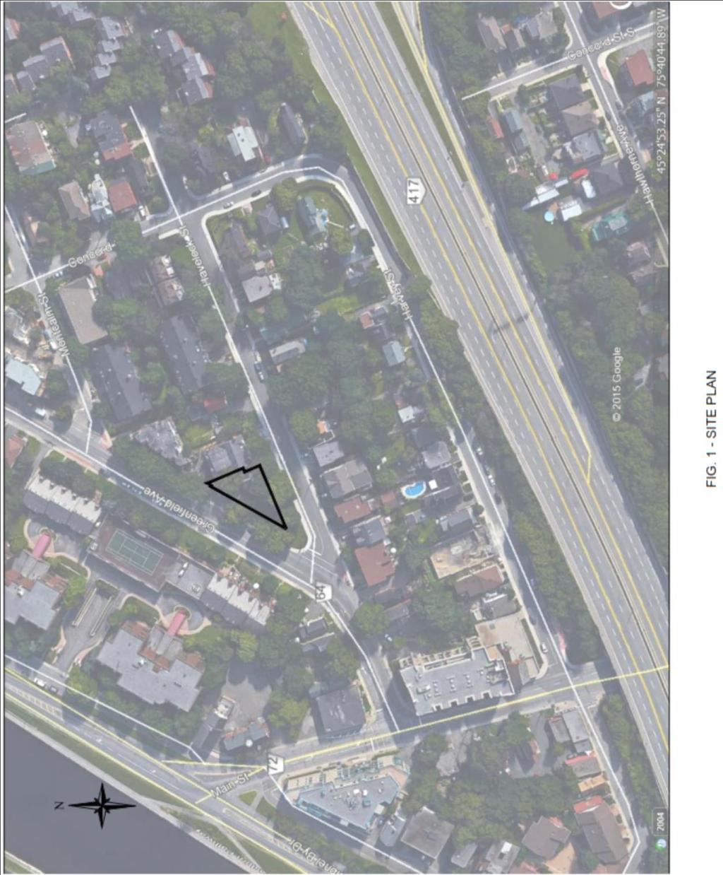
2 A1 NOISE IMPACT ASSESSMENT SURFACE DEVELOPMENTS 1.0 BACKGROUND A new 4-story residential complex constructed by Surface Developments has been planned at the corner of Greenfield Avenue and Havelock Street. The City of Ottawa requires a Noise Impact Assessment as part of the Site Plan Approval for the complex. Transportation routes within the influence zone of the proposed property include Havelock St. (Local Access Road), Greenfield Ave. (2-Lane Urban Arterial), Main St. (2-Lane Urban Arterial), and the Queensway (Divided Highway). The site lies to the north of the City of Ottawa Airport; however, it is outside the noise contours provided for that airport. Therefore, no consideration of airport noise is required. There are no railway lines within the influence distance of the development, so railway noise has not been considered. There are no stationary noise sources within the influence area. In summary, the noise sources that need to be taken into account for this development are: Greenfield Ave 2-Lane Urban Arterial Main St. 2-Lane Urban Arterial Queensway Divided Highway This study has been prepared in accordance with the City of Ottawa Environmental Noise Control Guidelines and the Ontario Ministry of the Environment Guideline NPC NOISE LEVELS AT SOURCE The noise levels from road traffic are determined by the number of lanes in a roadway, the type of roadway, and the posted speed limit. The type of roadway specifies the mix of vehicle types using that road during both day and night. Table 1 below taken from the Ottawa guidelines shows the data relevant to Greenfield Ave., Main St. and the Queensway. TABLE 1 ROAD DEFINITIONS AND RELATED TRAFFIC DATA Row Width(m) NA Implied Roadway Class Freeway, Queensway, Highway 2-Lane Urban Arterial AADT Vehicles /Day 18,333 per lane Posted Speed Km/h Day/Night Split % Medium Trucks % Heavy Trucks % / , /8 7 5
3 A2 For roads that are close to the receiver locations (distance from road centreline to receiver less than 50m), it is necessary to divide the traffic volumes into the two directions on the road. In the case, where the distance from the source to the receiver is greater than 50m, the source can be located at the centreline of the roadway as the reduction in the calculated noise level at the receiver will be less than 0.5 db. Since the minimum noise source/receiver distance allowed in the STAMSON model is 15 metres, the noise at most receivers can be calculated by STAMSON using the centreline model with difference of less than half a decibel from the two-lane model, and less than 0.1 db at receiver distances beyond 45 metres from the centreline. For the purposes of this study, the calculations performed on Greenfield and the Queensway have been divided into the two directions method, while the calculations performed on Main Street have been calculated using the centreline method. For all roads, it has been assumed that the traffic volumes are equal (half the AADT) in two directions along the directional lane centrelines. When noise barriers are used, elevation differences between the roadway, the barrier base, and the receiver location also affect the noise level at the receiver. Noise at all windows and outdoor living areas must take into account the elevation of that area above the ground. Table 2 shows the traffic volumes from Table 1 divided into day and night traffic and separated into automobiles, medium trucks, and heavy trucks according to the percentages giving in Table 1. TABLE 2 TRAFFIC VOLUME ALLOCATIONS Street AADT Day (0700h to 2259h) Night (2300h to 0659h) Total Total Total Total Medium Heavy Medium Automobiles Trucks Trucks Trucks Total Automobiles Total Heavy Trucks Greenfield Ave. 15,000 12, , Main St. 15,000 12, , East Queensway 73,332 59,369 4, , West Queensway 73,332 59,369 4, , The traffic speed on Main St. and Greenfield Ave. were set to 50 km/h and the Queensway was set at 100 km/h which are the posted speed limits for the respected roadways. This data was input into the traffic noise model STAMSON 5.1 to calculate noise levels at the various receiver locations. 3.0 NOISE LEVEL AT RECEIVERS The criteria for acceptability and remedial actions require noise levels to be calculated in Outdoor Living Areas (OLAs), and in the plane of the windows in Living Rooms, Dining Rooms, Bedrooms, or any other rooms that may be used for similar activities as in these rooms. The OLA noise criteria is the 16-hour Equivalent Noise Level (Leq 16Hr ) the noise level averaged over the daytime period from 0700h to 2259h (7:00AM to 10:59PM). The criteria for noise in
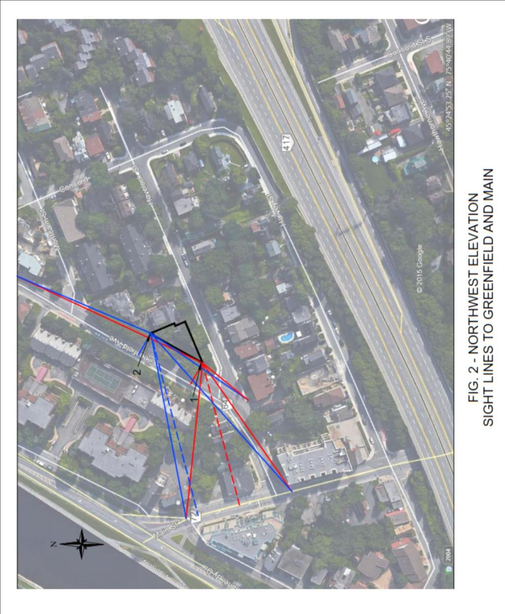
4 A3 Living Rooms and Dining Rooms (or similar rooms) are also based on the daytime 16-hour Leq. For Bedrooms, the acceptability criterion is based on the 8-hour Equivalent Noise level (Leq 8Hr) the noise level averaged over the night-time period from 2300h to 0659h (11:00PM to 6:59AM). It is not necessary to calculate the noise level at every window or wall in the proposed building. Calculation of noise levels at several receiver locations along a wall permits interpolation of noises levels at other points along the wall which are then the impact noise at those locations. For walls whose dimensions are small compared to the noise prorogation distance from the road source, calculation of impacting noise at the ends of the wall is usually sufficient; for walls that are close to the roadways or are irregular in plan view, more calculation points need to be taken, particularly if the irregularities in the wall planform would provide extensive shielding of some portions of the walls and windows. Where a receiver is exposed to more than one of the roadway noise sources, the total noise from all sources was calculated by the STAMSON model. A pre-existing barrier has been constructed on the north side of the Queensway. This barrier has been included in the calculations. Table 3 below shows the noise levels at the chosen representative locations. Figures 1, 2, and 3 shows the perpendicular distance from each of these receivers to the source roadway and the limiting sight lines that include the section creating the road noise. The STAMSON model has been calculated using a reflective ground surface everywhere and therefore the indicated noise levels are equal for all heights on the building at each calculation point. TABLE 3 STAMSON MODEL RESULTS: NOISE LEVELS AT REPRESENTATIVE RECEIVERS AT PLANE OF WINDOW Location Day (dba) Night (dba) Point 1 (North West Elevation Red) Point 2 (North West Elevation Blue) Point 3 (East Elevation Red) Point 4 (East Elevation- Blue) Point 5 (South Elevation Red) Point 6 (South Elevation Blue) Point OLA1 (West Rooftop Terrace - Red) 70.9 N/A Point OLA2 (East Rooftop Terrace - Blue) 70.6 N/A Tables 4 and 5 lists the criteria of acceptability and required actions for each type of receiver location. Each wall/window receiver location in Table 3 has to be assessed against both living room/dining room criteria (daytime Leq 16hr ) and night time criteria (Leq 8Hr ). Points OLA1 and OLA2 in Table 3 have been assessed for the Outdoor Living Area (daytime Leq 16hr ) criteria.
5 A4 Assessment Location Outdoor Living Area (OLA) TABLE 4 NOISE LEVEL CRITERIA Leq (8 or 16 hrs as Ventilation Outdoor Control noted) (dba) Requirements Measures Warning Clause Leq 16hr less than or equal to 55dBA N/A None required Not Required Leq 16hr greater than Control measures (barriers) Required if Leq 55dBA to less than N/A may not be required but exceeds 55dBA or equal to 60dBA should be considered Type A Leq 16hr greater than 60dBA N/A Control measures (barriers required to reduce the Leq to below 60dBA and as close to 55 dba as technically, economically and administratively feasible Required if Leq exceeds 55dBA Type B Assessment Location Plane of Living Room Window Plane of Bedroom Window Leq (8 or 16 hrs as noted) (dba) Leq 16hr less than or equal to 55dBA Leq 16hr greater than 55dBA to less than or equal to 65dBA Leq 16hr greater than 65dBA Leq 8hr greater than 50dBA to less than or equal to 60dBA Leq 8hr greater than 60dBA Ventilation Requirements Outdoor Control Measures Warning Clause None Required N/A Not Required Forced air heating with provision for central air conditioning Central air conditioning Forced air heating with provision for central air conditioning Central air conditioning N/A N/A N/A N/A Required Type C Required Type D Required Type C Required Type D TABLE 5 ROAD AND RAIL NOISE, DAY-TIME (0700h-2300h) AND NIGHT-TIME (2300h-0700h) BUILDING COMPONENT REQUIREMENTS Assessment Location Sound Level (time as noted) Building Component Requirements Leq 16h Less than or equal to 65 dba Building compliant with the Ontario Building Plane of Living Room Window Plane of Bedroom Window Road Rail Road Rail Leq 16h Greater than 65 dba Leq 16h Less than or equal to 60 dba Leq 16h Greater to 60 dba Leq 8h Less than or equal to 60 dba Leq 8h Greater than 60 dba Leq 8h Less than or equal to 60 dba Leq 8h Greater than 60 dba Code Building components (walls, windows, etc.) must be designed to achieve indoor sound level criteria Building compliant with the Ontario Building Code Building components (walls, windows, etc.) must be designed to achieve indoor sound level criteria Building compliant with the Ontario Building Code Building components (walls, windows, etc.) must be designed to achieve indoor sound level criteria Building compliant with the Ontario Building Code Building components (walls, windows, etc.) must be designed to achieve indoor sound level criteria
6 A5 Table 6 below provides the Warning Clauses TABLE 6 Warning Type Clauses Type Type A Type B Type C Type D Type E Warning Clause "Purchasers/tenants are advised that sound levels due to increasing (road) (Transitway) (rail) (air) traffic may occasionally interfere with some activities of the dwelling occupants as the sound levels exceed the City s and the Ministry of the Environment's noise criteria." "Purchasers/tenants are advised that despite the inclusion of noise control features in the development and within the building units, sound levels due to increasing (road) (Transitway) (rail) (air) traffic may on occasions interfere with some activities of the dwelling occupants as the sound levels exceed the City s and the Ministry of the Environment's noise criteria." "This dwelling unit has been fitted with a forced air heating system and the ducting, etc. was sized to accommodate central air conditioning. Installation of central air conditioning by the occupant will allow windows and exterior doors to remain closed, thereby ensuring that the indoor sound levels are within the City s and the Ministry of the Environment's noise criteria. (Note: The location and installation of the outdoor air conditioning device should be done so as to comply with noise criteria of MOE Publication NPC-216, Residential Air Conditioning Devices and thus minimize the noise impacts both on and in the immediate vicinity of the subject property." "This dwelling unit has been supplied with a central air conditioning system which will allow windows and exterior doors to remain closed, thereby ensuring that the indoor sound levels are within the City s and the Ministry of the Environment's noise criteria." "Purchasers/tenants are advised that due to the proximity of the adjacent industry (facility) (utility), sound levels from the industry (facility) (utility) may at times be audible The calculated noise levels result in the following requirements: Outdoor Living Areas: Rooftop Amenity Area (North Side of Main Roof - Totalling Approximately Half of Total Main Roof Area): Point OLA dba, Point OLA dba Barriers are required to reduce the sound levels below 60dBA and Type B warning clause is required. Proposed barrier heights of 1.83m at the roof parapet, parallel to Greenfield and a barrier height of 3.05m at the midspan of the roof parallel to Havelock and along the parapet perpendicular to Havelock provide readings of OLA1-59.9dBA and OLA2-59.4dBA. Further increasing the heights of the barriers does not drastically decrease the sound levels of the roof and therefore, it is not economical to do so. SEE ADDENDUM Living Room/Dining Room (Daytime) Northwest Elevation (Facing Main and Greenfield): Point dba, Point dba Ventilation system must be designed and provide for the installation of central air conditioning and the titles must include the Warning Clause Type D. The building components must be designed to achieve indoor sound level criteria
7 A6 North Side of East Elevation: Point dba Ventilation system must be designed and provide for the installation of central air conditioning and the titles must include the Warning Clause Type D. The building components must be designed to achieve indoor sound level criteria South Side of East Elevation: Point dba Ventilation system must be designed for the installation of forced air heating system which is designed to accommodate for the installation of an air conditioning system and the titles must include the Warning Clause Type C. The building must be building code compliant. South Elevation (Facing Queensway): Point dba, Point dba Ventilation system must be designed for the installation of forced air heating system which is designed to accommodate for the installation of an air conditioning system and the titles must include the Warning Clause Type C. The building must be building code compliant. Bedroom (Night-time) South Elevation (Facing Queensway): Point dba, Point dba Ventilation system must be designed for the installation of forced air heating system which is designed to accommodate the installation of an air conditioning system and the titles must include the Warning Clause Type C. The building must be building code compliant. Northwest Elevation (Facing Main and Greenfield): Point dba, Point dba Ventilation system must be designed and provide for the installation of central air conditioning and the titles must include the Warning Clause Type D. The building components must be designed to achieve indoor sound level criteria South Side of East Elevation: Point dba Ventilation system must be designed for the installation of forced air heating system which is designed to accommodate for the installation of an air conditioning system and the titles must include the Warning Clause Type C. The building must be building code compliant. North Side of East Elevation: Point dba Ventilation system must be designed for the installation of forced air heating system which is designed to accommodate the installation of an air conditioning system and the titles must include the Warning Clause Type C. The building must be building code compliant. 4.0 RECOMMENDATIONS & CONCLUSIONS The planned 4-storey residential complex located at Havelock St. and Greenfield Ave. will require the following design requirements and title warning clauses: The rooftop amenity area requires barriers of 1.83m at the roof parapet, parallel to Greenfield and a barrier height of 3.05m at the midspan of the roof parallel to Havelock


8 A7 and along the parapet perpendicular to Havelock. The OLA also requires the Type B Warning Clause SEE ADDENDUM The north side of the building requires the design and installation of air conditioning and the Type D Warning Clause as all points calculated exceed the daytime Leq 16Hr 65 dba requirement. In addition, special accommodations must be made to the building components to ensure that the interior sound levels are achieved The south side of the building requires forced air heating which is designed to accommodate the installation of air conditioning as well as the Type C Warning Clause as at all calculated points the daytime Leq was found to be between 55 dba and 65 dba while the nighttime Leq was found to be between 50 dba and 60 dba Trusting this meets with your present requirements, please feel free to contact us should you require further information. Steve Christison, P.Eng Neil Standen, P.Eng URBAN AERODYNAMICS LTD 07/24/17
9 A8 APPENDIX A: GLOSSARY
10 A9 Definitions: AADT "Annual Average Daily Traffic" is defined as the average twenty-four hour, two-way traffic for the period January 1 to December 31st dba - the A-weighted sound pressure level. Influence Area: The area detailed within the City Ottawa Noise Guidelines which indicates which sources need to be calculated for noise effect Leq - The Logarithmic Energy Equivalent Continuous Sound Level is the constant sound level over a time period that results in the same total sound energy as the actually varying sound. Leq is a measure of total sound energy dose over a specified time period. Leq 16Hr The Leq over the daytime period of 0700h to 2259h Leq 8Hr The Leq over the night-time period of 2300h to 0659h Outdoor Living Area (OLA): An outdoor amenity area provided recreational activities and for the quiet enjoyment of the outdoor environment. Receiver Location of calculation point on the building structure or in the OLA Source Location of origination of noise. Taken from the centre point of a traffic lane, stationary object or rail line STAMSON noise modeling software that calculates existing and future transportation noise levels; from Ontario Ministry of Environment
11 B1 APPENDIX B: FIGURES
12 B2
13 B3
14 B4
15 B5
16 C1 ADDENDUM OLA NOISE CALCULATIONS USING ISO NOISE MODEL
17 C2 Description of Noise Model The STAMSON road traffic impact noise model, used to calculate noise levels at receptor locations for Site Plan Approval purposes in Ottawa, has limitations which limit its ability to correctly represent traffic noise levels at some building locations. In this study, the Outdoor Living Area (OLA) is located on the roof of the building, enclosed by walls and fences that are located at various distances from the edges of the roof. For noise sources on the ground, this configuration can present a double-barrier situation, where the edge of the roof and either a wall or a fence both project into the noise propagation path between the noise source and the receiver. STAMSON is not designed to handle this configuration, allowing only a single barrier in the propagation path, and which must be located at the edge of the roof. Double barriers usually provide greater noise attenuation than single barriers of the same height, which means that single barriers typically need to be higher than a double-barrier configuration to obtain the same attenuation. Note that it is not necessary for each barrier in a double configuration to be the same height. STAMSON has other limitations that more recent traffic noise models accommodate. One of the major improvements in recent models is the use of spectra (third-octave or full-octave) to represent traffic noise. STAMSON calculates the overall noise level (Equivalent Noise Level = Leq) of the source traffic noise based on vehicle types and volumes, and uses the predominant frequency of 500Hz for any parameter that is frequency-dependent. Models that use spectra are able to represent the attenuation of sound by atmospheric conditions and absorption and reflection of sound energy by the ground along the noise propagation path, parameters that are dependent on the frequency spectrum, for a greater variety of conditions and greater accuracy in calculating noise levels at receptors. The model used in this Addendum is the ISO model 1, developed for the International Standards Organization (ISO). It supports the features discussed above, but it does not calculate the source traffic noise spectrum. The user is required to supply the full-octave spectrum of the noise source as an input to the model. Methodology for this Study (1) Source Traffic Noise The ISO model affects the calculated noise level in the OLA primarily by using different algorithms for the propagation of sound and the effect of barriers, as compared to the STAMSON model. It is advisable in this case to keep the noise level of the traffic the same as that calculated by STAMSON since it is only the propagation and barrier effects that are at variance with those permitted by the STAMSON model. Accordingly, because the ISO model requires a full-octave noise spectrum, it was necessary to choose a model spectrum and adjust its spectral values to produce the overall Leq calculated by STAMSON at the OLA. The Standard CMHC Spectrum used in the National Research Council noise model 1 International Standard ISO : Acoustics Attenuation of Sound during Propagation Outdoors Part 2: General Method of Calculation
18 C3 IBANA was used here as the spectrum model, and it s noise level at each third-octave frequency band was adjusted to give the overall level calculated by STAMSON (without barriers) at the OLA reception point, for each road source. These noise levels were taken directly from the STAMSON data in Appendix C. FIGURE B1 (2.) Geometry of the Rooftop OLA, Walls and Fences and Calculation Point Figure B2 shows the layout of the OLA on the roof. The calculation point is shown as X. This point does not conform to the requirements of the Ottawa Environmental Noise Control Guidelines (2016) but was selected after consultation with City staff. The locations of the proposed barrier walls and 1-metre protective glass boundary fencing, both of which constitute the noise barriers, are shown relative to the roof edges. The (red) barrier wall was taken to be 1.83 metres (6 ft) high; the glass guard was set at 42 inches ( 1 metre) high.
19 C4 FIGURE B2: OLA, CALCULATION POINT AND NOISE BARRIER WALLS AND GUARD FENCES
20 C5 (3.) Data Preparation and Model Setup Data for the distances and exposure angles of each roadway to the building walls was taken directly from the STAMSON data sheets in Appendix C. Building height and relative elevations were also taken as appropriate from the STAMSON data. Locations of the Calculation Point and barrier walls and guard fences relative to the building edges were taken from Figure B2. The noise levels from each roadway without barriers were taken from the STAMSON data and used to calculate the full-octave spectral levels for the CMHC Standard Spectrum, at the rooftop for each roadway, without barriers. Each octave band noise level was adjusted by the same amount, and the band levels summed on an anti-logarithmic basis until the STAMSON overall level was obtained. The ground condition between all roadways and the building was taken to be hard and atmospheric conditions were taken to be a light wind from the roadway to the building (mild downwind propagation) as standard in ISO , and with atmospheric sound absorption coefficients for an average temperature of 10 C and 70% humidity. Results The ISO model is currently an Excel spreadsheet, performing the calculations specified in the ISO document. As such, there is no pro forma presentation of all the setup data. Accordingly, the spreadsheet images of the setup tables for each road are attached. The calculations of the noise from each roadway are shown in the attached tables. Added together on an antilogarithmic basis, the total noise level at the Calculation Point is Leq(16hr) = 59.4dBA. This is acceptable under the Environmental Noise Control Guidelines (2016) for an OLA (Leq(16hr) < 60dBA) provided a Type B Warning Clause is attached to all Titles. URBAN AERODYNAMICS LTD Neil M. Standen, PEng
21 C6
22 C7 FIGURE B3: DATA TABLES FROM EXCEL SPREADSHEET OF ISO
23 C8 APPENDIX C: STAMSON CALCULATIONS
24 C9 STAMSON 5.0 SUMMARY REPORT Date: :15:51 MINISTRY OF ENVIRONMENT AND ENERGY / NOISE ASSESSMENT Filename: point1.te Description: Time Period: Day/Night 16/8 hours Road data, segment # 1: W.Green (day/night) Car traffic volume : 6072/528 veh/timeperiod Medium truck volume : 483/42 veh/timeperiod Heavy truck volume : 345/30 veh/timeperiod Posted speed limit : 50 km/h Data for Segment # 1: W.Green (day/night) Angle1 Angle2 : deg deg No of house rows : 0 / 0 Receiver source distance : / m Receiver height : 2.50 / 4.50 m Topography : 1 (Flat/gentle slope; no barrier) Road data, segment # 2: E.Green (day/night) Car traffic volume : 6072/528 veh/timeperiod Medium truck volume : 483/42 veh/timeperiod Heavy truck volume : 345/30 veh/timeperiod Posted speed limit : 50 km/h Data for Segment # 2: E.Green (day/night) Angle1 Angle2 : deg deg No of house rows : 0 / 0 Receiver source distance : / m Receiver height : 2.50 / 4.50 m Topography : 1 (Flat/gentle slope; no barrier)
25 C10 Road data, segment # 3: Main (day/night) Car traffic volume : 12144/1056 veh/timeperiod Medium truck volume : 966/84 veh/timeperiod Heavy truck volume : 690/60 veh/timeperiod Posted speed limit : 50 km/h Data for Segment # 3: Main (day/night) Angle1 Angle2 : deg deg No of house rows : 0 / 0 Receiver source distance : / m Receiver height : 2.50 / 4.50 m Topography : 1 (Flat/gentle slope; no barrier) Result summary (day) ! source! Road! Total! height! Leq! Leq! (m)! (dba)! (dba) 1.W.Green! 1.50! 64.70! E.Green! 1.50! 65.12! Main! 1.50! 53.91! Total dba Result summary (night) ! source! Road! Total! height! Leq! Leq! (m)! (dba)! (dba) 1.W.Green! 1.50! 57.11! E.Green! 1.50! 57.52! Main! 1.50! 46.32! Total dba
26 C11 TOTAL Leq FROM ALL SOURCES (DAY): (NIGHT): Data Adjustment for Source-Reciever<15.0m E.Green= 20 log(15.0m/10.0m)=3.54 dba Result summary (day) ! source! Road! Total! height! Leq! Leq! (m)! (dba)! (dba) 1.W.Green! 1.50! 64.70! E.Green! 1.50! 68.66! Main! 1.50! 53.91! Total dba Result summary (night) ! source! Road! Total! height! Leq! Leq! (m)! (dba)! (dba) 1.W.Green! 1.50! 57.11! E.Green! 1.50! 61.06! Main! 1.50! 46.32! Total dba TOTAL Leq FROM ALL SOURCES (DAY): (NIGHT): 62.60
27 C12 STAMSON 5.0 SUMMARY REPORT Date: :16:18 MINISTRY OF ENVIRONMENT AND ENERGY / NOISE ASSESSMENT Filename: point2.te Description: Time Period: Day/Night 16/8 hours Road data, segment # 1: W.Green (day/night) Car traffic volume : 6072/528 veh/timeperiod Medium truck volume : 483/42 veh/timeperiod Heavy truck volume : 345/30 veh/timeperiod Posted speed limit : 50 km/h Data for Segment # 1: W.Green (day/night) Angle1 Angle2 : deg deg No of house rows : 0 / 0 Receiver source distance : / m Receiver height : 2.50 / 4.50 m Topography : 1 (Flat/gentle slope; no barrier) Road data, segment # 2: E.Green (day/night) Car traffic volume : 6072/528 veh/timeperiod Medium truck volume : 483/42 veh/timeperiod Heavy truck volume : 345/30 veh/timeperiod Posted speed limit : 50 km/h Data for Segment # 2: E.Green (day/night) Angle1 Angle2 : deg deg No of house rows : 0 / 0 Receiver source distance : / m Receiver height : 2.50 / 4.50 m Topography : 1 (Flat/gentle slope; no barrier)
28 C13 Road data, segment # 3: Main (day/night) Car traffic volume : 12144/1056 veh/timeperiod Medium truck volume : 966/84 veh/timeperiod Heavy truck volume : 690/60 veh/timeperiod Posted speed limit : 50 km/h Data for Segment # 3: Main (day/night) Angle1 Angle2 : deg 4.00 deg No of house rows : 0 / 0 Receiver source distance : / m Receiver height : 2.50 / 4.50 m Topography : 1 (Flat/gentle slope; no barrier) Result summary (day) ! source! Road! Total! height! Leq! Leq! (m)! (dba)! (dba) 1.W.Green! 1.50! 64.78! E.Green! 1.50! 65.20! Main! 1.50! 51.72! Total dba Result summary (night) ! source! Road! Total! height! Leq! Leq! (m)! (dba)! (dba) 1.W.Green! 1.50! 57.19! E.Green! 1.50! 57.60! Main! 1.50! 44.12! Total dba TOTAL Leq FROM ALL SOURCES (DAY): (NIGHT): 60.51
29 C14 Data Adjustment for Source-Reciever<15.0m E.Green= 20 log(15.0m/10.0m)=3.54 dba Result summary (day) ! source! Road! Total! height! Leq! Leq! (m)! (dba)! (dba) 1.W.Green! 1.50! 64.78! E.Green! 1.50! 68.74! Main! 1.50! 51.72! Total dba Result summary (night) ! source! Road! Total! height! Leq! Leq! (m)! (dba)! (dba) 1.W.Green! 1.50! 57.19! E.Green! 1.50! 61.14! Main! 1.50! 44.12! Total dba TOTAL Leq FROM ALL SOURCES (DAY): (NIGHT): 62.67
30 C15 TAMSON 5.0 SUMMARY REPORT Date: :30:34 MINISTRY OF ENVIRONMENT AND ENERGY / NOISE ASSESSMENT Filename: point3.te Description: Time Period: Day/Night 16/8 hours Road data, segment # 1: W.Green (day/night) Car traffic volume : 6072/528 veh/timeperiod Medium truck volume : 483/42 veh/timeperiod Heavy truck volume : 345/30 veh/timeperiod Posted speed limit : 50 km/h Data for Segment # 1: W.Green (day/night) Angle1 Angle2 : deg deg No of house rows : 0 / 0 Receiver source distance : / m Receiver height : 2.50 / 4.50 m Topography : 1 (Flat/gentle slope; no barrier) Road data, segment # 2: E.Green (day/night) Car traffic volume : 6072/528 veh/timeperiod Medium truck volume : 483/42 veh/timeperiod Heavy truck volume : 345/30 veh/timeperiod Posted speed limit : 50 km/h Data for Segment # 2: E.Green (day/night) Angle1 Angle2 : deg deg No of house rows : 0 / 0 Receiver source distance : / m Receiver height : 2.50 / 4.50 m Topography : 1 (Flat/gentle slope; no barrier)
31 C16 Road data, segment # 3: W.Queensway (day/night) Car traffic volume : 59369/5163 veh/timeperiod Medium truck volume : 4722/411 veh/timeperiod Heavy truck volume : 3373/293 veh/timeperiod Posted speed limit : 100 km/h Data for Segment # 3: W.Queensway (day/night) Angle1 Angle2 : 3.00 deg deg No of house rows : 2 / 2 House density : 75 % Receiver source distance : / m Receiver height : 2.50 / 4.50 m Topography : 4 (Elevated; with barrier) Barrier angle1 : 3.00 deg Angle2 : deg Barrier height : 2.80 m Elevation : 3.00 m Barrier receiver distance : / m Source elevation : 3.00 m Receiver elevation : 0.00 m Barrier elevation : 3.00 m Road data, segment # 4: E.Queensway (day/night) Car traffic volume : 59369/5163 veh/timeperiod Medium truck volume : 4722/411 veh/timeperiod Heavy truck volume : 3373/293 veh/timeperiod Posted speed limit : 100 km/h Data for Segment # 4: E.Queensway (day/night) Angle1 Angle2 : 3.00 deg deg No of house rows : 2 / 2 House density : 75 % Receiver source distance : / m Receiver height : 2.50 / 4.50 m Topography : 4 (Elevated; with barrier) Barrier angle1 : 3.00 deg Angle2 : deg Barrier height : 2.80 m Elevation : 3.00 m Barrier receiver distance : / m
32 C17 Source elevation : 3.00 m Receiver elevation : 0.00 m Barrier elevation : 3.00 m Result summary (day) ! source! Road! Total! height! Leq! Leq! (m)! (dba)! (dba) 1.W.Green! 1.50! 58.71! E.Green! 1.50! 59.45! W.Queensway! 1.50! 59.04! E.Queensway! 1.50! 59.69! Total dba Result summary (night) ! source! Road! Total! height! Leq! Leq! (m)! (dba)! (dba) 1.W.Green! 1.50! 51.11! E.Green! 1.50! 51.85! W.Queensway! 1.49! 52.10! E.Queensway! 1.49! 53.00! Total dba TOTAL Leq FROM ALL SOURCES (DAY): (NIGHT): Data Adjustment for Source-Reciever<15.0m E.Green= 20 log(15.0m/10.0m)=3.54 dba Result summary (day) ! source! Road! Total! height! Leq! Leq! (m)! (dba)! (dba) 1.W.Green! 1.50! 58.71! E.Green! 1.50! 62.99! W.Queensway! 1.50! 59.04! 59.04
33 C18 4.E.Queensway! 1.50! 59.69! Total dba Result summary (night) ! source! Road! Total! height! Leq! Leq! (m)! (dba)! (dba) 1.W.Green! 1.50! 51.11! E.Green! 1.50! 55.39! W.Queensway! 1.49! 52.10! E.Queensway! 1.49! 53.00! Total dba TOTAL Leq FROM ALL SOURCES (DAY): (NIGHT): STAMSON 5.0 SUMMARY REPORT Date: :33:11 MINISTRY OF ENVIRONMENT AND ENERGY / NOISE ASSESSMENT Filename: point4.te Description: Time Period: Day/Night 16/8 hours Road data, segment # 1: W.Green (day/night) Car traffic volume : 6072/528 veh/timeperiod Medium truck volume : 483/42 veh/timeperiod Heavy truck volume : 345/30 veh/timeperiod Posted speed limit : 50 km/h Data for Segment # 1: W.Green (day/night) Angle1 Angle2 : deg deg No of house rows : 0 / 0 Receiver source distance : / m Receiver height : 2.50 / 4.50 m Topography : 1 (Flat/gentle slope; no barrier)
34 C19 Road data, segment # 2: E.Green (day/night) Car traffic volume : 6072/528 veh/timeperiod Medium truck volume : 483/42 veh/timeperiod Heavy truck volume : 345/30 veh/timeperiod Posted speed limit : 50 km/h Data for Segment # 2: E.Green (day/night) Angle1 Angle2 : deg deg No of house rows : 0 / 0 Receiver source distance : / m Receiver height : 2.50 / 4.50 m Topography : 1 (Flat/gentle slope; no barrier) Road data, segment # 3: W.Queensway (day/night) Car traffic volume : 59369/5163 veh/timeperiod Medium truck volume : 4722/411 veh/timeperiod Heavy truck volume : 3373/293 veh/timeperiod Posted speed limit : 100 km/h Data for Segment # 3: W.Queensway (day/night) Angle1 Angle2 : 3.00 deg deg No of house rows : 2 / 2 House density : 75 % Receiver source distance : / m Receiver height : 2.50 / 4.50 m Topography : 4 (Elevated; with barrier) Barrier angle1 : 3.00 deg Angle2 : deg Barrier height : 2.80 m Elevation : 3.00 m Barrier receiver distance : / m Source elevation : 3.00 m Receiver elevation : 0.00 m Barrier elevation : 3.00 m
35 C20 Road data, segment # 4: E.Queensway (day/night) Car traffic volume : 59369/5163 veh/timeperiod Medium truck volume : 4722/411 veh/timeperiod Heavy truck volume : 3373/293 veh/timeperiod Posted speed limit : 100 km/h Data for Segment # 4: E.Queensway (day/night) Angle1 Angle2 : 3.00 deg deg No of house rows : 2 / 2 House density : 75 % Receiver source distance : / m Receiver height : 2.50 / 4.50 m Topography : 4 (Elevated; with barrier) Barrier angle1 : 3.00 deg Angle2 : deg Barrier height : 2.80 m Elevation : 3.00 m Barrier receiver distance : / m Source elevation : 3.00 m Receiver elevation : 0.00 m Barrier elevation : 3.00 m Result summary (day) ! source! Road! Total! height! Leq! Leq! (m)! (dba)! (dba) 1.W.Green! 1.50! 54.61! E.Green! 1.50! 55.41! W.Queensway! 1.50! 59.04! E.Queensway! 1.50! 59.69! Total dba Result summary (night) ! source! Road! Total! height! Leq! Leq! (m)! (dba)! (dba) 1.W.Green! 1.50! 47.01! 47.01
36 C21 2.E.Green! 1.50! 47.82! W.Queensway! 1.49! 52.10! E.Queensway! 1.49! 53.00! Total dba TOTAL Leq FROM ALL SOURCES (DAY): (NIGHT): STAMSON 5.0 SUMMARY REPORT Date: :18:36 MINISTRY OF ENVIRONMENT AND ENERGY / NOISE ASSESSMENT Filename: point5.te Description: Time Period: Day/Night 16/8 hours Road data, segment # 1: W.Queensway (day/night) Car traffic volume : 59369/5163 veh/timeperiod Medium truck volume : 4722/411 veh/timeperiod Heavy truck volume : 3373/293 veh/timeperiod Posted speed limit : 100 km/h Data for Segment # 1: W.Queensway (day/night) Angle1 Angle2 : deg deg No of house rows : 2 / 2 House density : 75 % Receiver source distance : / m Receiver height : 2.50 / 4.50 m Topography : 4 (Elevated; with barrier) Barrier angle1 : deg Angle2 : deg Barrier height : 2.80 m Elevation : 3.00 m Barrier receiver distance : / m Source elevation : 3.00 m Receiver elevation : 0.00 m Barrier elevation : 3.00 m
37 C22 Road data, segment # 2: E.Queensway (day/night) Car traffic volume : 59369/5163 veh/timeperiod Medium truck volume : 4722/411 veh/timeperiod Heavy truck volume : 3373/293 veh/timeperiod Posted speed limit : 100 km/h Data for Segment # 2: E.Queensway (day/night) Angle1 Angle2 : deg deg No of house rows : 2 / 2 House density : 75 % Receiver source distance : / m Receiver height : 2.50 / 4.50 m Topography : 4 (Elevated; with barrier) Barrier angle1 : deg Angle2 : deg Barrier height : 2.80 m Elevation : 3.00 m Barrier receiver distance : / m Source elevation : 3.00 m Receiver elevation : 0.00 m Barrier elevation : 3.00 m Road data, segment # 3: Main (day/night) Car traffic volume : 12144/1056 veh/timeperiod Medium truck volume : 966/84 veh/timeperiod Heavy truck volume : 690/60 veh/timeperiod Posted speed limit : 50 km/h Data for Segment # 3: Main (day/night) Angle1 Angle2 : 9.00 deg deg No of house rows : 0 / 0 Receiver source distance : / m Receiver height : 2.50 / 4.50 m Topography : 1 (Flat/gentle slope; no barrier)
38 C23 Result summary (day) ! source! Road! Total! height! Leq! Leq! (m)! (dba)! (dba) 1.W.Queensway! 1.50! 62.21! E.Queensway! 1.50! 62.86! Main! 1.50! 48.31! Total dba Result summary (night) ! source! Road! Total! height! Leq! Leq! (m)! (dba)! (dba) 1.W.Queensway! 1.49! 55.27! E.Queensway! 1.49! 56.18! Main! 1.50! 40.71! Total dba TOTAL Leq FROM ALL SOURCES (DAY): (NIGHT): STAMSON 5.0 SUMMARY REPORT Date: :21:04 MINISTRY OF ENVIRONMENT AND ENERGY / NOISE ASSESSMENT Filename: point6.te Description: Time Period: Day/Night 16/8 hours Road data, segment # 1: W.Queensway (day/night) Car traffic volume : 67465/5867 veh/timeperiod Medium truck volume : 4722/411 veh/timeperiod Heavy truck volume : 3373/293 veh/timeperiod Posted speed limit : 100 km/h
39 C24 Data for Segment # 1: W.Queensway (day/night) Angle1 Angle2 : deg deg No of house rows : 2 / 2 House density : 75 % Receiver source distance : / m Receiver height : 2.50 / 4.50 m Topography : 4 (Elevated; with barrier) Barrier angle1 : deg Angle2 : deg Barrier height : 2.80 m Elevation : 3.00 m Barrier receiver distance : / m Source elevation : 3.00 m Receiver elevation : 0.00 m Barrier elevation : 3.00 m Road data, segment # 2: E.Queensway (day/night) Car traffic volume : 67465/5867 veh/timeperiod Medium truck volume : 4722/411 veh/timeperiod Heavy truck volume : 3373/293 veh/timeperiod Posted speed limit : 100 km/h Data for Segment # 2: E.Queensway (day/night) Angle1 Angle2 : deg deg No of house rows : 2 / 2 House density : 75 % Receiver source distance : / m Receiver height : 2.50 / 4.50 m Topography : 4 (Elevated; with barrier) Barrier angle1 : deg Angle2 : deg Barrier height : 2.80 m Elevation : 3.00 m Barrier receiver distance : / m Source elevation : 3.00 m Receiver elevation : 0.00 m Barrier elevation : 3.00 m
40 C25 Road data, segment # 3: Main (day/night) Car traffic volume : 12144/1056 veh/timeperiod Medium truck volume : 966/84 veh/timeperiod Heavy truck volume : 690/60 veh/timeperiod Posted speed limit : 50 km/h Data for Segment # 3: Main (day/night) Angle1 Angle2 : 9.00 deg deg No of house rows : 0 / 0 Receiver source distance : / m Receiver height : 2.50 / 4.50 m Topography : 1 (Flat/gentle slope; no barrier) Result summary (day) ! source! Road! Total! height! Leq! Leq! (m)! (dba)! (dba) 1.W.Queensway! 1.45! 62.43! E.Queensway! 1.45! 63.13! Main! 1.50! 45.86! Total dba Result summary (night) ! source! Road! Total! height! Leq! Leq! (m)! (dba)! (dba) 1.W.Queensway! 1.45! 55.49! E.Queensway! 1.45! 56.45! Main! 1.50! 38.27! Total dba TOTAL Leq FROM ALL SOURCES (DAY): (NIGHT): 59.04
41 C26 STAMSON 5.0 SUMMARY REPORT Date: :05:27 MINISTRY OF ENVIRONMENT AND ENERGY / NOISE ASSESSMENT Filename: ola1.te Time Period: Day/Night 16/8 hours Description: Noise Levels without Barriers at Location 1 in Rooftop OLA Road data, segment # 1: W.Green (day/night) Car traffic volume : 6072/528 veh/timeperiod Medium truck volume : 483/42 veh/timeperiod Heavy truck volume : 345/30 veh/timeperiod Posted speed limit : 50 km/h Data for Segment # 1: W.Green (day/night) Angle1 Angle2 : deg deg No of house rows : 0 / 0 Receiver source distance : / m Receiver height : / 4.50 m Topography : 1 (Flat/gentle slope; no barrier) Road data, segment # 2: E.Green (day/night) Car traffic volume : 6072/528 veh/timeperiod Medium truck volume : 483/42 veh/timeperiod Heavy truck volume : 345/30 veh/timeperiod Posted speed limit : 50 km/h Data for Segment # 2: E.Green (day/night) Angle1 Angle2 : deg deg No of house rows : 0 / 0 Receiver source distance : / m Receiver height : / 4.50 m Topography : 1 (Flat/gentle slope; no barrier)
42 C27 Road data, segment # 3: Main (day/night) Car traffic volume : 12144/1056 veh/timeperiod Medium truck volume : 966/84 veh/timeperiod Heavy truck volume : 690/60 veh/timeperiod Posted speed limit : 50 km/h Data for Segment # 3: Main (day/night) Angle1 Angle2 : deg deg No of house rows : 0 / 0 Receiver source distance : / m Receiver height : / 4.50 m Topography : 1 (Flat/gentle slope; no barrier) Road data, segment # 4: E.Queensway (day/night) Car traffic volume : 59369/5163 veh/timeperiod Medium truck volume : 4722/411 veh/timeperiod Heavy truck volume : 3373/293 veh/timeperiod Posted speed limit : 100 km/h Data for Segment # 4: E.Queensway (day/night) Angle1 Angle2 : deg deg No of house rows : 2 / 2 House density : 75 % Receiver source distance : / m Receiver height : / m Topography : 4 (Elevated; with barrier) Barrier angle1 : deg Angle2 : deg Barrier height : 2.80 m Elevation : 3.00 m Barrier receiver distance : / m Source elevation : 3.00 m Receiver elevation : 0.00 m Barrier elevation : 3.00 m
43 C28 Road data, segment # 5: W.Queensway (day/night) Car traffic volume : 59369/5163 veh/timeperiod Medium truck volume : 4722/411 veh/timeperiod Heavy truck volume : 3373/293 veh/timeperiod Posted speed limit : 100 km/h Data for Segment # 5: W.Queensway (day/night) Angle1 Angle2 : deg deg No of house rows : 2 / 2 House density : 75 % Receiver source distance : / m Receiver height : / m Topography : 4 (Elevated; with barrier) Barrier angle1 : deg Angle2 : deg Barrier height : 2.80 m Elevation : 3.00 m Barrier receiver distance : / m Source elevation : 3.00 m Receiver elevation : 0.00 m Barrier elevation : 3.00 m Result summary (day) ! source! Road! Total! height! Leq! Leq! (m)! (dba)! (dba) 1.W.Green! 1.50! 64.04! E.Green! 1.50! 65.07! Main! 1.50! 53.24! E.Queensway! 1.50! 63.80! * 5.W.Queensway! 1.50! 64.23! * Total dba * Bright Zone! TOTAL Leq FROM ALL SOURCES (DAY): 70.42
44 C29 Data Adjustment for Source-Reciever<15.0m E.Green= 20 log(15.0m/12.5m)=1.58 dba Result summary (day) ! source! Road! Total! height! Leq! Leq! (m)! (dba)! (dba) 1.W.Green! 1.50! 64.04! E.Green! 1.50! 65.07! Main! 1.50! 53.24! E.Queensway! 1.50! 63.80! * 5.W.Queensway! 1.50! 64.23! * Total 70.9 dba * Bright Zone! TOTAL Leq FROM ALL SOURCES (DAY): 70.9 STAMSON 5.0 SUMMARY REPORT Date: :16:46 MINISTRY OF ENVIRONMENT AND ENERGY / NOISE ASSESSMENT Filename: ola1need.te Time Period: Day/Night 16/8 hours Description: Noise Levels with Barriers Needed to Comply with Ottawa ENCG at Point OLA1 in Rooftop OLA Road data, segment # 1: W.Green (day/night) Car traffic volume : 6072/528 veh/timeperiod Medium truck volume : 483/42 veh/timeperiod Heavy truck volume : 345/30 veh/timeperiod Posted speed limit : 50 km/h Data for Segment # 1: W.Green (day/night) Angle1 Angle2 : deg deg No of house rows : 0 / 0
45 C30 Receiver source distance : / m Receiver height : / 4.50 m Topography : 2 (Flat/gentle slope; with barrier) Barrier angle1 : deg Angle2 : deg Barrier height : 1.82 m Barrier receiver distance : 1.50 / 1.50 m Source elevation : 1.50 m Receiver elevation : 0.00 m Barrier elevation : m Road data, segment # 2: E.Green (day/night) Car traffic volume : 6072/528 veh/timeperiod Medium truck volume : 483/42 veh/timeperiod Heavy truck volume : 345/30 veh/timeperiod Posted speed limit : 50 km/h Data for Segment # 2: E.Green (day/night) Angle1 Angle2 : deg deg No of house rows : 0 / 0 Receiver source distance : / m Receiver height : / 4.50 m Topography : 2 (Flat/gentle slope; with barrier) Barrier angle1 : deg Angle2 : deg Barrier height : 1.82 m Barrier receiver distance : 1.50 / 1.50 m Source elevation : 1.50 m Receiver elevation : 0.00 m Barrier elevation : m Road data, segment # 3: Main (day/night) Car traffic volume : 12144/1056 veh/timeperiod Medium truck volume : 966/84 veh/timeperiod Heavy truck volume : 690/60 veh/timeperiod Posted speed limit : 50 km/h
46 C31 Data for Segment # 3: Main (day/night) Angle1 Angle2 : deg deg No of house rows : 0 / 0 Receiver source distance : / m Receiver height : / 4.50 m Topography : 2 (Flat/gentle slope; with barrier) Barrier angle1 : deg Angle2 : deg Barrier height : 1.82 m Barrier receiver distance : 1.50 / 1.50 m Source elevation : 1.50 m Receiver elevation : 0.00 m Barrier elevation : m Road data, segment # 4: E.Queensway (day/night) Car traffic volume : 59369/5163 veh/timeperiod Medium truck volume : 4722/411 veh/timeperiod Heavy truck volume : 3373/293 veh/timeperiod Posted speed limit : 100 km/h Data for Segment # 4: E.Queensway (day/night) Angle1 Angle2 : deg deg No of house rows : 2 / 2 House density : 75 % Receiver source distance : / m Receiver height : / m Topography : 4 (Elevated; with barrier) Barrier angle1 : deg Angle2 : deg Barrier height : 3.05 m Elevation : m Barrier receiver distance : 1.50 / 1.50 m Source elevation : 3.00 m Receiver elevation : 0.00 m Barrier elevation : m
47 C32 Road data, segment # 5: W.Queensway (day/night) Car traffic volume : 59369/5163 veh/timeperiod Medium truck volume : 4722/411 veh/timeperiod Heavy truck volume : 3373/293 veh/timeperiod Posted speed limit : 100 km/h Data for Segment # 5: W.Queensway (day/night) Angle1 Angle2 : deg deg No of house rows : 2 / 2 House density : 75 % Surface : 1 (Absorptive ground surface) Receiver source distance : / m Receiver height : / m Topography : 4 (Elevated; with barrier) Barrier angle1 : deg Angle2 : deg Barrier height : 3.05 m Elevation : m Barrier receiver distance : 1.50 / 1.50 m Source elevation : 3.00 m Receiver elevation : 0.00 m Barrier elevation : m Result summary (day) ! source! Road! Total! height! Leq! Leq! (m)! (dba)! (dba) 1.W.Green! 1.50! 51.68! E.Green! 1.50! 51.78! Main! 1.50! 44.86! E.Queensway! 1.50! 54.53! W.Queensway! 1.50! 54.90! Total dba Result summary (night) ! source! Road! Total! height! Leq! Leq! (m)! (dba)! (dba)