PLANNED UNIT DEVELOPMENT STAFF REPORT Date: September 7, 2017
|
|
|
- Emerald McKenzie
- 5 years ago
- Views:
Transcription
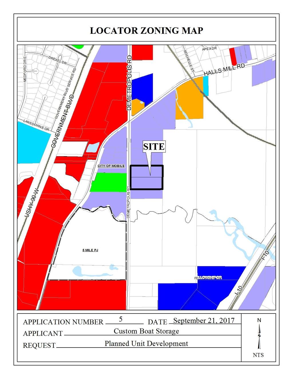
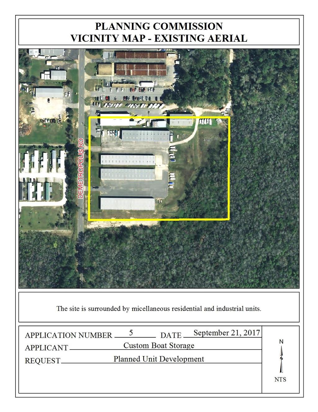
1 PLANNED UNIT DEVELOPMENT STAFF REPORT Date: September 7, 2017 DEVELOPMENT NAME LOCATION Custom Boat Storage 3975 Demetropolis Road (East side of Demetropolis Road, 0.2± miles South of Halls Mill Road.) CITY COUNCIL DISTRICT District 4 PRESENT ZONING AREA OF PROPERTY I-1, Light Industry 1 Lot / 5.45± Acres CONTEMPLATED USE Planned Unit Development Approval to amend a previously approved Planned Unit Development to allow multiple buildings on a single building site. TIME SCHEDULE FOR DEVELOPMENT None. ENGINEERING COMMENTS ADD THE FOLLOWING NOTES TO THE PUD SITE PLAN: 1) Provide a note that a 25' riparian buffer may be required, during development, along the edge of anything considered (by ADEM) to be a water of the state. 2) The approval of all applicable federal, state, and local agencies (including all storm water runoff, wetland and floodplain requirements) will be required prior to the issuance of a Land Disturbance permit. The Owner/Developer is responsible for acquiring all of the necessary permits and approvals. 3) The proposed development must comply with all Engineering Department design requirements and Policy Letters. TRAFFIC ENGINEERING Site is limited to the existing curb cuts with any changes to number, size, location and design to be approved by Traffic Engineering and conform to AASHTO standards. URBAN FORESTRY COMMENTS Property to be developed in compliance with state and local laws that pertain to tree preservation and protection on both city and private properties (State Act and City Code Chapters 57 and 64).
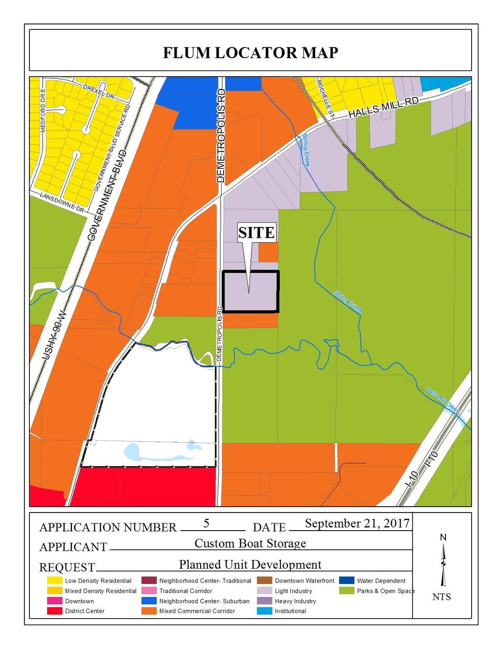
2 FIRE DEPARTMENT COMMENTS All projects within the City Limits of Mobile shall comply with the requirements of the City of Mobile Fire Code Ordinance (2012 International Fire Code). REMARKS The applicant is requesting Planned Unit Development approval to amend a previously approved Planned Unit Development to allow multiple buildings on a single building site. Planned Unit Development (PUD) review examines the site with regard to its location to ensure that it is generally compatible with neighboring uses; that adequate access is provided without generating excess traffic along minor residential streets in residential districts outside the PUD; and that natural features of the site are taken into consideration. PUD review also examines the design of the development to provide for adequate circulation within the development; to ensure adequate access for emergency vehicles; and to consider and provide for protection from adverse effects of adjacent properties as well as provide protection of adjacent properties from adverse effects from the PUD. PUD approval is site-plan specific, thus if any new construction is anticipated that will change an approved site plan, an application to amend an existing, approved PUD must be made prior to any construction activities. PUD approval expires in one year if no permits are obtained. The site has been given a Light Industry land use designation per the recently adopted Future Land Use Plan and Map. The Future Land Use Plan and Map complements and provides additional detail to the Development Framework Maps in the Map for Mobile, adopted by the Planning Commission at its November 5, 2015 meeting. This land use designation applies to an array of modern, low-impact industrial uses that include assembly and processing, warehousing, distribution, and wholesaling facilities. The bulk of the light industrial use must be contained within a building or facility. If a light industrial use requires outside storage, the storage must be limited in area and appropriately screened from view in accordance to specific zoning requirements. This designation may also include uses such as complementary offices and retail. Light Industry also includes areas that may be regarded as industrial business, where the land uses include business administration and logistics operations for industrial concerns, building trade contractor facilities and advanced research facilities, as well as stand-alone education, scientific and industrial research facilities; or, any combination of those facilities located in light industrial and technology parks. Many parcels used for industrial business are smaller and scattered throughout Mobile. For this reason, these parcels are not singled-out in the Future Land Use Map, but are instead addressed through zoning. Light industrial uses are characterized by attractive, accessible and connected development compatible with the character of surrounding neighborhoods. Development may take the form of planned campuses in park-like settings or unified design corridors, with consideration to factors such as: site and building orientation; building design; landscaping and buffering; lighting; continuity of pedestrian networks; and, access and connectivity to transit and to freight transportation. It should be noted that heavy commercial and, in some cases, high-density residential land uses may serve as transitions between Light Industry and other, lower-intensity land use designations. Also, protection buffers may be required by Zoning
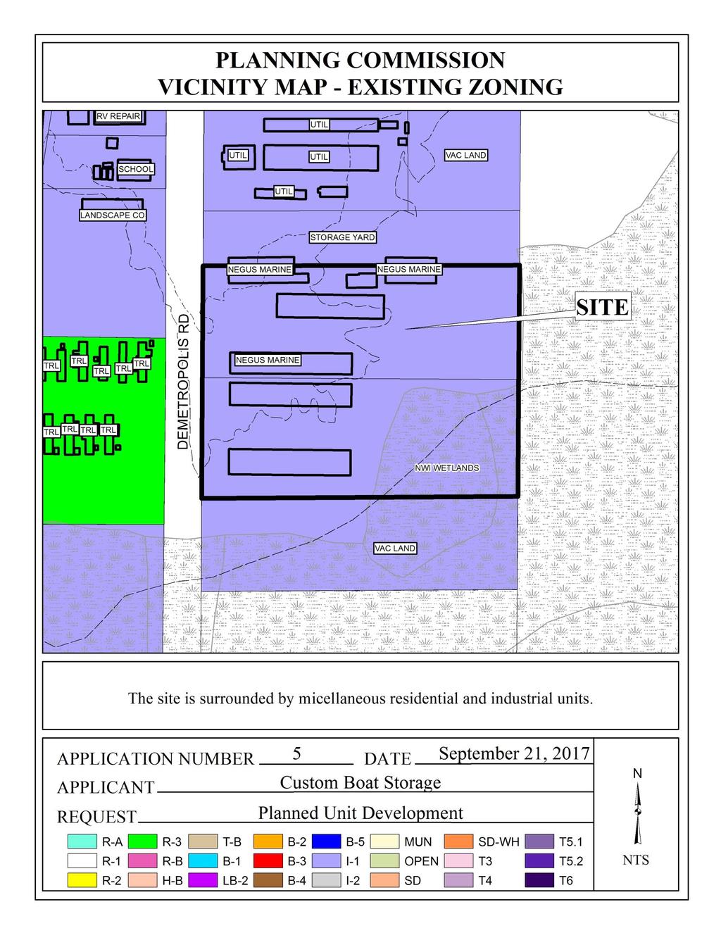
3 It should also be noted that the Future Land Use Plan and Map components of the Map for Mobile Plan are meant to serve as a general guide, not a detailed lot and district plan. In many cases the designation on the new Future Land Use Map may match the existing use of land, but in others the designated land use may differ from what is on the ground today. As such, the Future Land Use Plan and Map allows the Planning Commission and City Council to consider individual cases based on additional information such as the classification request, the surrounding development, the timing of the request, and the appropriateness and compatibility of the proposed use and, where applicable, the zoning classification. The site is developed as a boat storage facility, a use allowed by right in an I-1, Light Industry district, and was originally the subject of Administrative PUD approval in 1996 for a portion of the re-subdivided Lot 1 of the 2-lot subdivision approved at the October 21, 2004 meeting of the Planning Commission. Also approved at the October 21, 2004 meeting was: a Sidewalk Waiver to waive construction of a sidewalk along Demetropolis Road; a PUD to amend the Administrative PUD for proposed expansion of the development; and, Rezoning to accommodate a change from B-3, Community Business District, to I-1, Light Industry District, to eliminate split-zoning of the resulting Lot 2. Rezoning of Lot 2 was adopted at the February 22, 2005 meeting of the City Council. The applicant now wishes to amend the PUD to accommodate expansion of an existing building to include 900 square feet of office space, thus the need for additional PUD approval. The subject site appears to have been developed on the previously approved Lot 1 of the aforementioned 2-lot subdivision, as well as on an adjacent lot to the North with multiple buildings and shared access. The original PUD request did not illustrate such a layout, and neither does the proposed PUD amendment. As such, revision of the site plan to illustrate all lots to which the development has access should be required. The site plan provides information concerning off-street parking, but there is a discrepancy between this information and off-street parking information for the previously approved PUD. Furthermore, no parking is illustrated even though some parking appears to exist, accessed from the property to the North. As such, revision of the site plan should be required to illustrate parking in compliance with Section 64-6 of the Zoning Ordinance. A photometric plan is not required due to the limited scope of the project; however, any new site lighting is to comply with Section 64-4.A.2. and 64-6.A.3.c. of the Zoning Ordinance. Tree and landscaping data is provided, but is inconsistent with the previously approved PUD and is not fully illustrated on the site plan. Also, the site plan does not reflect existing tree and landscaping conditions. As such, revision of the site plan should be required to illustrate compliance with the landscaping percentage and frontage tree planning requirements of Section 64-4.E.3.a. of the Zoning Ordinance. A dumpster is not depicted on the site plan and one is not discernable in recent aerial photos. Any dumpster placed on the property must be in compliance with the current enclosure and sanitary sewer connection requirements of Section 64-4.D.9. of the Zoning Ordinance, and must - 3 -
4 be illustrated on any revised site plan(s); or, a note must be provided on the site plan stating curbside pickup will be utilized. Aerial photos indicate that boats and trailers are being stored on grass and dirt, otherwise considered unimproved surfaces. The Zoning Ordinance requires, at minimum, an aggregate surface; therefore, revision of the site plan to illustrate appropriate surfacing where boat and trailer storage occurs should be required. It should be noted that the site plan depicts an existing chain link fence when it is, in fact, a wrought iron-style fence that is located differently than as depicted. Finally, regarding the Future Land Use Plan and Map, a majority of boat storage on the property appears to be enclosed per recent aerial photographs and Google Street View images from December, 2016; however, some boats are visible from the street. As such, an appropriate buffer in the form of a wall, wooden privacy fence, or the inclusion of a screen planting strip to reduce visibility of outside storage should be considered. Such a buffer should be illustrated on any revised site plan(s). RECOMMENDATION Based upon the preceding, this application is recommended for Holdover to the October 19, 2017 meeting with revisions due by September 29, 2017 to allow the applicant to address the following: 1) revision of the site plan to illustrate all lots to which the development has access; 2) revision of the site plan to illustrate existing and required parking in compliance with Section 64-6 of the Zoning Ordinance; 3) revision of the site plan to illustrate compliance with the landscaping percentage and frontage tree planning requirements of Sections 64-4.E.3.a. of the Zoning Ordinance, to include the replacement of any required trees; 4) revision of the site plan to illustrate compliance with the dumpster requirements of Section 64-4.D.9. of the Zoning Ordinance, or placement of a note on the site plan stating curbside pickup will be utilized; 5) revision of the site plan to show the accurate location and type of fence provided; 6) revision of the plan to depict proper surfacing on boat and trailer storage areas (to eliminate grass and/or dirt parking); and, 7) consideration of providing an appropriate buffer to reduce visibility of outside storage
5 - 5 -
6 - 6 -
7 - 7 -
8 - 8 -
9 - 9 -
10 - 10 -
11 - 11 -
12 - 12 -