Project Summary: - Hydrologic Models. - LiDAR Based - 10 Synthetic Events - No Historic Events - 100yr Runoff is Largest - Assumes Even Rainfall
|
|
|
- Melinda Phillips
- 5 years ago
- Views:
Transcription
1
 - LiDAR Based -")

2 Project Summary: - Hydrologic Models Phase 2 Underway Nearly Completed (Park/Pembina EOY) - LiDAR Based - 10 Synthetic Events - No Historic Events - 100yr Runoff is Largest - Assumes Even Rainfall Phase 1 - Completed

3


4 USACE Improvements underway Grand Forks to Pembina Emerson, MB Traverse to Grand Forks - Completed Lake Traverse
5 FM Metro Basinwide RRBC LTFS Basinwide Flow Reduction Strategy Primary Purpose Basinwide Project Assessment 20% Main stem flow reduction (Goal) Considerations May not be best scenario for Fargo Main stem Modeling with HEC-HMS inflows not complete D/S of Halstad, MN. FM Metro Diversion Authority Retention Project Funding Primary Purpose Identify impacts of Detention on 100-yr discharge at Fargo, ND Funding method ology Considerations Multiple event evaluation may be beneficial

6 Step 1 When Does It Occur? Standard Melt Progression
7 Step 1 When Does It Occur? Standard Melt Progression
8
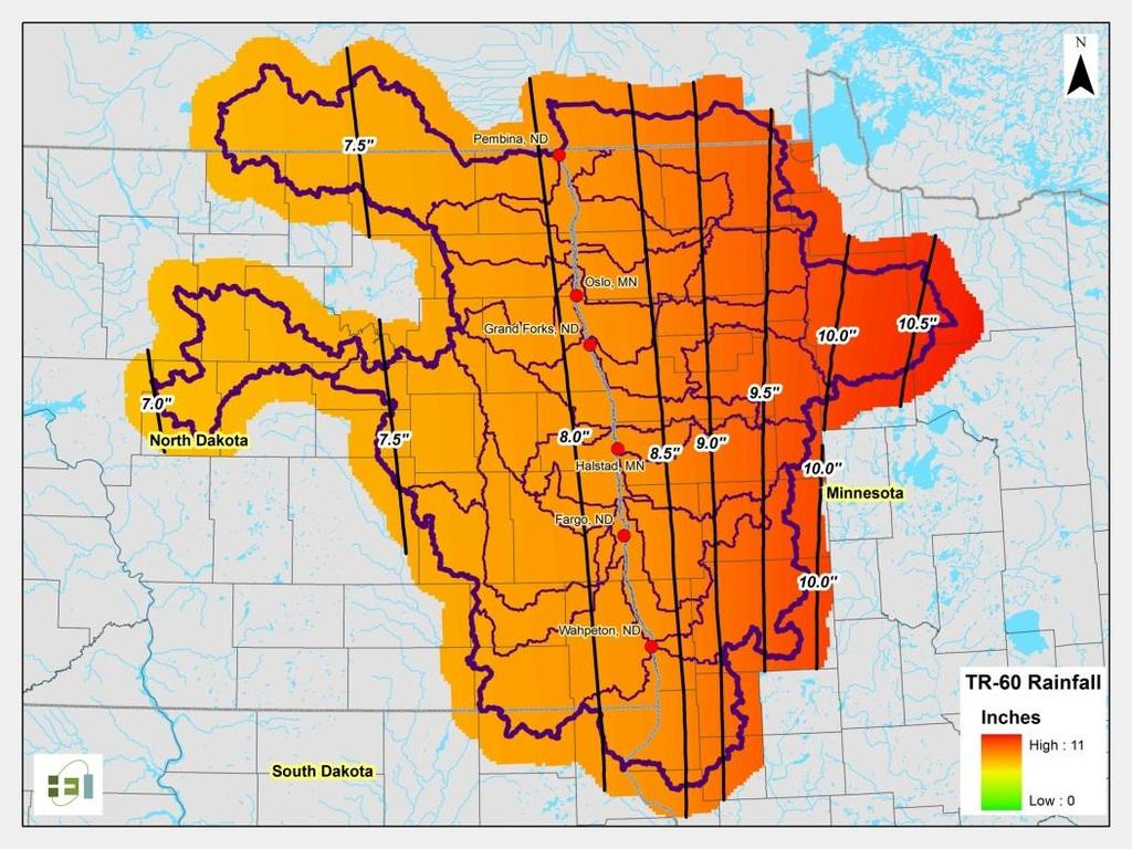
9 Step 1 When Does It Occur? Standard Melt Progression Step 2 How Much? 1.5, 2.5, 3.5, 4.5, and 5.5 (TR-60)
10 Step 1 When Does It Occur? Standard Melt Progression Step 2 How Much? 1.5, 2.5, 3.5, 4.5, and 5.5 (TR-60) Step 3 How Fast? 4-Day, 7-Day, and 10-Day Melt Duration
11 Step 1 When Does It Occur? Standard Melt Progression Step 2 How Much? 1.5, 2.5, 3.5, 4.5, and 5.5 (TR-60) Step 3 How Fast? 4-Day, 7-Day, and 10-Day Melt Duration Step 4 Differences During Larger Floods? Top 10 Floods At Fargo


12 Step 1 When Does It Occur? Standard Melt Progression Step 2 How Much? 1.5, 2.5, 3.5, 4.5, and 5.5 (TR-60) Step 3 How Fast? 4-Day, 7-Day, and 10-Day Melt Duration Step 4 Differences During Larger Floods? Top 10 Floods At Fargo


13 4-Day Melt Duration Full Period of Record Melt Progression
14 FM Metro Basinwide Primary Purpose Evaluate alternatives to proposed diversion project Considerations 100-yr Discharge Scenario at Fargo may not be best Basinwide approach Only screening levee assessment is needed RRBC LTFS Basinwide Flow Reduction Strategy Primary Purpose Basinwide Project Assessment 20% Main stem flow reduction (Goal) Considerations May not be best scenario for Fargo Main stem Modeling with HEC-HMS inflows not complete D/S of Halstad, MN. FM Metro Diversion Authority Retention Project Funding MN DNR EIS FM Metro Alternative Analysis Primary Purpose Identify impacts of Detention on 100-yr discharge at Fargo, ND Funding method ology Considerations Multiple event evaluation may be beneficial USACE Diversion Analysis Primary Purpose Project design and operation Considerations Additional detail may be necessary Planning vs. design level detail


15 ND Comprehensive Detention Plans MN Expanded Distributed Detention Strategy Large Scale Sites Identification of all apparent sites WRD Involvement Multiple proposed conditions scenarios Multiple Runoff Events Establish benefit within Tributaries Establish reduction to Red River main stem Detailed reporting Large Scale Sites Identification of sites required to meet LTFS goals Limited WD Involvement One proposed condition Standard melt progression event only Establish benefit within Tributaries Establish reduction to Red River main stem Generalized reporting
16
17 Methodology Site Identification Criteria Control minimum of 20 square miles Avoid impacts to residential structures / infrastructure Store a minimum of 3 inches of runoff Avoid mainstem locations in lower 2/3 of watershed Primarily select off-channel & stream locations Reasonable levee heights & inundation impacts Modeling Assumptions Gated with E.S. 5 feet below top of levee Dry storage, no conservation pools Analysis All Sites Combined Comparison of Individual Sites Comparison of Combined Sites

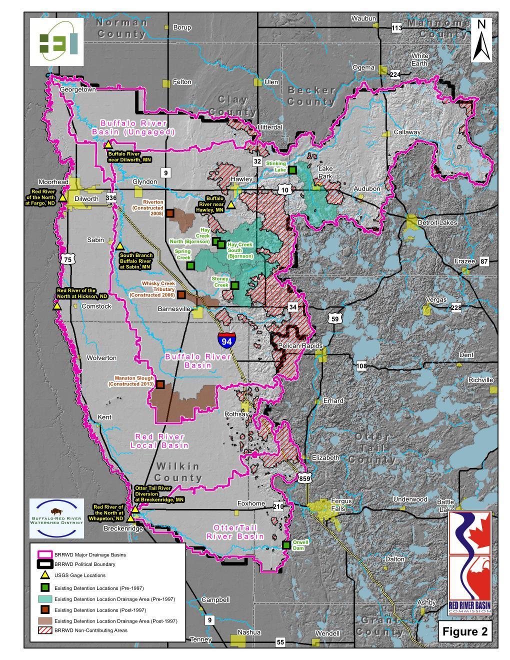
18 Proposed Sites
19 Elm River Watershed Results - Summary 35% watershed control by new sites (43% total) 6 Sites in the Elm Watershed (4.4% of Watershed) Elm Watershed Sites: 16.2 mi 2 pool at spillway 21.5 mi 2 pool at top of dam 39,971 Ac-Ft volume at spillway 3.3 inch avg. at spillway 100-yr Runoff (Elm River) 43% Peak Reduction 32% Vol. Reduction LTFS target = 13% Peak
20 ND Comprehensive Detention Plans MN Expanded Distributed Detention Strategy Large Scale Sites Identification of all apparent sites WRD Involvement Multiple proposed conditions scenarios Multiple Runoff Events Establish benefit within Tributaries Establish reduction to Red River main stem Detailed reporting Large Scale Sites Identification of sites required to meet LTFS goals Limited WD Involvement One proposed condition Standard melt progression event only Establish benefit within Tributaries Establish reduction to Red River main stem Generalized reporting

21
 Detention Site Statistics LiDAR Derived Elevation/Storage Data LiDAR Derived Contributing Watershed Consider construction/environmental impacts of gated pool elevations Goal: 3 4 of gated")
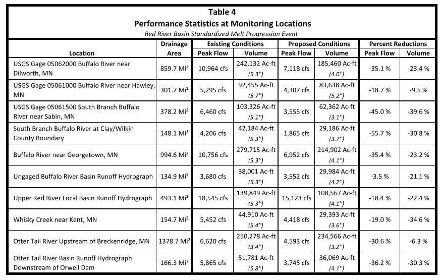
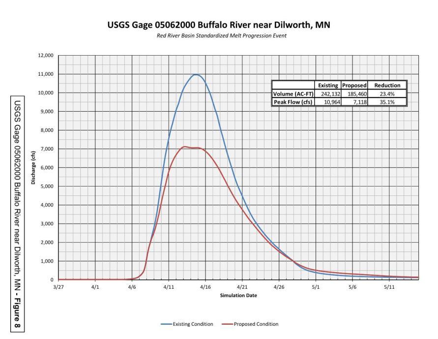
 & 100-yr, 10-day Runoff (Snow melt progression included) Reporting Existing conditions (Pre-1997) vs Proposed Conditions (Site Outlet, Damage areas, USGS")
22 Detention Site Identification Project Planning Tool Incorporation Watershed District/LGU Involvement Upstream of local damage areas Large Site Concepts (greater than 10 square miles most in the 30 SM range) Detention Site Statistics LiDAR Derived Elevation/Storage Data LiDAR Derived Contributing Watershed Consider construction/environmental impacts of gated pool elevations Goal: 3 4 of gated storage per site (Meet LTFS Volume and Peak Goals) Hydrologic Analysis - Benefits Red River Basin HEC-HMS developed by the US Army Corps of Engineers Incorporate Identified Detention Sites Assume all gates closed 25, 50, 100-yr Rainfall (10-day) & 100-yr, 10-day Runoff (Snow melt progression included) Reporting Existing conditions (Pre-1997) vs Proposed Conditions (Site Outlet, Damage areas, USGS Gages) Watershed scale mapping only Report Summarizing Analysis
23
24 TASK 1 - Ongoing Sensitivity Analysis and MNDNR EIS Modeling Revisions Additional QA/QC of HEC-HMS to HEC-RAS Input - Completed Update HEC-RAS Model with Revised Base Conditions HEC-HMS Model Results Completed Melt Progression Scenario based on Top 10 Red River Floods - Completed Melt Progression Scenarios Based on Varied duration of Temporal Distribution - Completed Update Existing HMS with Varied Melt Progressions Completed Updated Existing Condition HEC-RAS with Varied Melt Progressions Completed *Coordination with Technical Committee/MNDNR/USACE* *USACE/MnDNR/NDSWC Peer Review* TASK 2 - Future With-Retention Conditions Scenario Modeling With-Retention Model Results Preliminary Funding Concepts *Coordination with Technical Committee/MNDNR/USACE* *USACE/MnDNR/NDSWC Peer Review* TASK 3 Prioritization for Funding/Reporting Retention Prioritization Finalize funding concept Reporting/Finalizing Outcomes *Coordination with Technical Committee/MNDNR/USACE* *USACE/MnDNR/NDSWC Peer Review*
25 TASK 1 - Ongoing Sensitivity Analysis and MNDNR EIS Modeling Revisions Additional QA/QC of HEC-HMS to HEC-RAS Input - Completed Update HEC-RAS Model with Revised Base Conditions HEC-HMS Model Results Completed Melt Progression Scenario based on Top 10 Red River Floods - Completed Melt Progression Scenarios Based on Varied duration of Temporal Distribution - Completed Update Existing HMS with Varied Melt Progressions Completed Updated Existing Condition HEC-RAS with Varied Melt Progressions Completed *Coordination with Technical Committee/MNDNR/USACE* *USACE/MnDNR/NDSWC Peer Review* TASK 2 - Future With-Retention Conditions Scenario Modeling With-Retention Model Results Preliminary Funding Concepts *Coordination with Technical Committee/MNDNR/USACE* *USACE/MnDNR/NDSWC Peer Review* TASK 3 Prioritization for Funding/Reporting Retention Prioritization Finalize funding concept Reporting/Finalizing Outcomes *Coordination with Technical Committee/MNDNR/USACE* *USACE/MnDNR/NDSWC Peer Review*


26