For personal use only
|
|
|
- Caitlin Black
- 5 years ago
- Views:
Transcription


1 Sean Kelly About Krucible Non executive Chairman Allan Branch Managing Director & CEO Ray Koenig Non executive Director ASX Announcement KRUCIBLE METALS LTD Mineral Discovery Company ABN: ASX Code: KRB 5th June 2014 Boulia South Exploration Report HIGHLIGHTS In May 2014, Krucible completed its first soil sampling at Coorabulka EPM19286 and the new adjacent Valroy tenement (EPM25126). In previous announcements the Company has described the existence of concretionary nodules containing strongly anomalous rare earth values. Andrew Vigar Non executive Director & CP Bridgette Humphries Samples from first pass, wide spaced surface geochemical sampling grids at Coorabulka and Valroy have been subjected to preliminary analysis using a portable Olympus Delta (DP4050 HCR) XRF machine. Senior Geologist Mike Meintjes Company Secretary & CFO Office : 1/68 Railway Avenue, Railway Estate, Townsville, Queensland 4810 Australia Post: PO BOX 499 Castletown, Townsville, Queensland 4812 Australia Phone: Fax: admin@kruciblemetals.com.au Listed on Australia s main stock exchange since 2007, Krucible is an Australian based resources company with an enviable history of discovery in phosphorus and heavy rare earths as well as other elements. Krucible continues to explore for precious metals, base metals and others, and is transitioning to a combined exploration and mining company. Krucible has plans and expectations to ultimately enter joint ventures to develop mines on tenements in the mineral rich Mount Isa area of north western Queensland. Krucible has a strong industry based board and management, who promote aggressive value added mining projects. Results from this analysis have returned up to 1074 yttrium and strontium at Valroy. Coorabulka lies over a magnetic anomaly that is scheduled to be explored in July 2014 (ASX Announcement 3rd June 2014).
 enrichment, strontium, phosphate, and lead.")
2 Boulia South Exploration Report (Yttrium and strontium anomalism widened) The Boulia South area encompasses Krucible s Coorabulka (EPM19286) and Valroy (EPM25126) EPMs (Figure 1). These are adjacent to each other and are both highly prospective for REE (Rare Earth Elements) enrichment, strontium, phosphate, and lead. Previous work has included reconnaissance sampling which has returned up to 0.62kg/t dysprosium oxide, 4.49kg/t neodymium oxide, 1.07kg/t praseodymium oxide, 3.16kg/t yttrium oxide, 1050 lead and 9.47% strontium (refer to ASX announcement 30 th January 2013 for full results) on the Coorabulka EPM and up to 6.54kg/t cerium oxide, 2.98kg/t neodymium oxide, 0.83kg/t praseodymium oxide, 0.39kg/t yttrium oxide, 15.1% phosphate (refer to ASX announcement 30 th January 2013 for full results) on the Valroy EPM. Work conducted this year has extended the exploration area and added to our knowledge of these prospects. 1
3 Valroy EPM25126 Valroy is Krucible s most recently granted EPM and was chosen because of interpretations suggesting REE enrichment may be wider spread than initially thought. In May 2014 Krucible completed a 400m by 400m lag surface sampling grid over this identified anomalous area. The outcropping units consisted of a strongly oxidised siltstone overlaying a soft white fine grained siltstone. The samples were subjected to portable XRF analysis using an Olympus Delta (DP-4050-HCR). Sample ID XRF results from the samples have indicated strongly anomalous rare earth potential (see Figure 3). Results from this are considered relative only and not laboratory quality. The device does not include most of the REE elements to the detection limits needed, however associated elements including strontium and yttrium give strong indications of further rare earth anomalism as well as increasing the target areas for these associated minerals. The portable XRF device returned values up to 1074 yttrium (1.36kg/t yttrium oxide), 6.49% strontium, 2.1% phosphorous (5.04% phosphate), 2497 cerium (3.56kg/t cerium oxide) and 825 lead (see Table 1 below). Easting AGD66 Northing AGD66 Ba Ba +/- Ce Ce +/- VALA VALA ND VALA VALA VALA VALA VALA VALA ND VALA VALA VALA Table 1 Valroy EPM Preliminary Anomalous Lag Sampling Results P P +/- Pb Pb +/- Sr Sr +/- Y N.B. the portable XRF machine will report the results with a margin of error (+/-) which are included in the table above. Please refer to the specifications for the XRF at for further limitations of this XRF machine. Results will be confirmed with laboratory assays shortly. The results from this portable XRF device are considered by Krucible to be strongly anomalous and indicate a wider area of potential enrichment than previously known. Krucible is eagerly awaiting the ALS Laboratory results expected in approximately 4 weeks. Y +/- 2
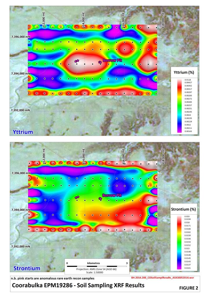
4 Coorabulka EPM19286 In May 2014 Krucible also completed a soil sampling program encompassing the two borrow pits where previous anomalous samples are located. The grid was a wide-spaced, first-pass attempt to find zones of potential REE enrichment on the prospect. The samples have been subjected to portable XRF (x-ray fluorescence) analysis using an Olympus Delta (DP-4050-HCR). Results from this device are considered representative only and not absolute (see above). Samples have been sent to ALS Laboratories for analysis and results are expected in approximately 4 weeks. Sample No The values returned from the XRF machine have indicated further potential anomalous REE results within the Coorabulka prospect area (see Table 2). The device is not able to detect the heavy REE to a required level at present however the presence of the light REE as well as strontium, yttrium and barium would suggest that these elements are present in the anomalous samples. The two borrow pits show up convincingly in the yttrium analysis however are not identified in the strontium results (Figure 2). Interestingly the most southern line appears from the results to have a number of anomalous samples as well as a separate anomaly in the north-eastern corner of the sampling grid. These results are considered encouraging by Krucible. The Company is waiting in anticipation for the laboratory results at which time Krucible may expand the grid to encompass these new expected peripheral anomalies. Easting (AGD66) Northing (AGD66) Ba (%) Ba +/- (%) P (%) P +/- (%) Sr (%) Sr +/- (%) Y (%) Y +/- (%) Zn (%) COOS COOS COOS COOS ND COOS COOS ND COOS ND COOS ND Table 2 Coorabulka Soil Sampling Preliminary Anomalous Results N.B. the portable XRF machine will report the results with a margin of error (+/-) which are included in the table above. Results will be confirmed with laboratory assays shortly. In addition to Krucible s interest in the rare earths found at Coorabulka, the tenement sits over a low density, strong magnetic anomaly expected to be less than 300m below surface (Figure 4). The Company is finalising its plans for exploring this target of the EPM. Zn +/- (%) 3
5 Attached: Figures 2-4 Annexure A Further Information: Allan Branch Managing Director & CEO 5 June 2014 About Krucible Metals Limited: Listed on Australia s main stock exchange since 2007, Krucible is an Australian-based resources company with an enviable history of discovery in phosphorus and rare earths as well as other elements. Krucible continues to explore for precious metals, base metals and strategic metals, and is transitioning to a combined exploration and mining company. Krucible has plans and expectations to ultimately enter joint ventures to develop mines on its tenements in the mineral rich Mount Isa area of northwestern Queensland and elsewhere. Krucible has a strong industry-based board and management, who promote aggressive value-added mining projects. COMPETENT PERSON STATEMENT The information in this report that relates to Mineral resources and Exploration Results is based on information compiled by Mr Andrew J Vigar who is a Fellow of The Australasian Institute of Mining and Metallurgy and is employed by Mining Associates Limited, Hong Kong and is a non-executive director of Krucible Metals Ltd. Mr Vigar has sufficient experience which is relevant to the style of mineralisation and type of deposit under consideration and to the activity which he is undertaking to qualify as a Competent Person as defined in the 2012 Edition of the Australasian Code for Reporting of Exploration Results, Mineral Resources and Ore Reserves. Mr Vigar consents to the inclusion in this report of the matters based on his information in the form and context in which it appears. Results are from a portable XRF DP-4050-HCR device and are not considered laboratory grade results. Phosphate results are calculated using the conversion factor yttrium oxide results are calculated using the conversion factor 1.27 and cerium oxide calculated using conversion factor 1.22 This report may contain forward-looking statements. Any forward-looking statements reflect management s current beliefs based on information currently available to management and are based on what management believes to be reasonable assumptions. A number of factors could cause actual results, or expectations to differ materially from the results expressed or implied in the forward looking statements. 4
6 Annexure A Table 1 Sampling Techniques and Data Criteria JORC Code explanation Commentary Sampling techniques Drilling techniques Drill sample recovery Logging Nature and quality of sampling (eg cut channels, random chips, or specific specialised industry standard measurement tools appropriate to the minerals under investigation, such as down hole gamma sondes, or handheld XRF instruments, etc). These examples should not be taken as limiting the broad meaning of sampling. Include reference to measures taken to ensure sample representivity and the appropriate calibration of any measurement tools or systems used. Aspects of the determination of mineralisation that are Material to the Public Report. In cases where industry standard work has been done this would be relatively simple (eg reverse circulation drilling was used to obtain 1 m samples from which 3 kg was pulverised to produce a 30 g charge for fire assay ). In other cases more explanation may be required, such as where there is coarse gold that has inherent sampling problems. Unusual commodities or mineralisation types (eg submarine nodules) may warrant disclosure of detailed information. Drill type (eg core, reverse circulation, openhole hammer, rotary air blast, auger, Bangka, sonic, etc) and details (eg core diameter, triple or standard tube, depth of diamond tails, facesampling bit or other type, whether core is oriented and if so, by what method, etc). Method of recording and assessing core and chip sample recoveries and results assessed. Measures taken to maximise sample recovery and ensure representative nature of the samples. Whether a relationship exists between sample recovery and grade and whether sample bias may have occurred due to preferential loss/gain of fine/coarse material. Whether core and chip samples have been geologically and geotechnically logged to a level of detail to support appropriate Mineral Resource estimation, mining studies and metallurgical studies. Whether logging is qualitative or quantitative in nature. Core (or costean, channel, etc) photography. Lag Sampling - Surface geochemical sampling technique involving the collection of surface rock material from a specific point and sieving to fraction size +2mm -6mm. Soil Sampling - Surface geochemical sampling technique involving the collection of soil material in this case from 40-45cm below surface at a specific GPS location. Sample was sieved to -2mm fraction size before bagged. The samples were collected at a number of sites within a 100m radius of the GPS point. Each sample was on average 1-2kg. No mineralisation identified in the field refer to XRF results Element results are taken from a portable XRF device which does not give results to a laboratory standard but do give a relative indication of any potential enrichment. Samples were analysed by the device once with a calibration completed every 10 samples. 5
7 Table 1 Cont. Criteria JORC Code explanation Commentary The total length and percentage of the relevant intersections logged. If core, whether cut or sawn and whether quarter, half or all core taken. Subsampling techniques and sample preparation If non-core, whether riffled, tube sampled, rotary split, etc and whether sampled wet or dry. For all sample types, the nature, quality and appropriateness of the sample preparation technique. Quality control procedures adopted for all sub-sampling stages to maximise representivity of samples. Measures taken to ensure that the sampling is representative of the in situ material collected, including for instance results for field duplicate/second-half sampling. Quality of assay data and laboratory tests Verification of sampling and assaying Location of data points Whether sample sizes are appropriate to the grain size of the material being sampled. The nature, quality and appropriateness of the assaying and laboratory procedures used and whether the technique is considered partial or total. For geophysical tools, spectrometers, handheld XRF instruments, etc, the parameters used in determining the analysis including instrument make and model, reading times, calibrations factors applied and their derivation, etc. Nature of quality control procedures adopted (eg standards, blanks, duplicates, external laboratory checks) and whether acceptable levels of accuracy (ie lack of bias) and precision have been established. The verification of significant intersections by either independent or alternative company personnel. Sample sizes are considered appropriate to the grain size of the material collected. These are not laboratory results. Results quoted are from a portable XRF analyser. These are considered preliminary indications and Laboratory results are expected on these samples in approximately 4 weeks. Used an Olympus XRF (DP-4050-HCR) soil mode used on the Valroy samples which uses 3 radiation beams which took on average 60seconds per beam The Coorabulka samples were read on the geochemical mode reading time was on average 30seconds on each beam and a total of 2 beams.. The device was calibrated using the standard calibration sample from Olympus every 10 readings. Calibration using an Olympus standard check was completed every 10 readings to ensure the accuracy of the device. The use of twinned holes. Documentation of primary data, data entry procedures, data verification, data storage (physical and electronic) protocols. All data was collected initially on paper ledgers which have been transferred to a digital database with the company's coding templates. Discuss any adjustment to assay data. No adjustments have been made Accuracy and quality of surveys used to locate drill holes (collar and down-hole surveys), trenches, mine workings and other locations used in Mineral Resource estimation. Sample points were located using a Garmin 76 GPS with an accuracy of 5m Specification of the grid system used. All surveys were MGA Zone54 (AGD66) 6
8 Table 1 Cont. Criteria JORC Code explanation Commentary Data spacing and distribution Quality and adequacy of topographic control. Data spacing for reporting of Exploration Results. Whether the data spacing and distribution is sufficient to establish the degree of geological and grade continuity appropriate for the Mineral Resource and Ore Reserve estimation procedure(s) and classifications applied. Topographical control is sufficient for the stage of exploration Sample points were on a 400x800m spacing on the Coorabulka EPM with 2 infill rows and 400x400m spacing s on the Valroy prospect Not sufficient sampling to determine resource Orientation of data in relation to geological structure Whether sample compositing has been applied. Whether the orientation of sampling achieves unbiased sampling of possible structures and the extent to which this is known, considering the deposit type. Not Applied No bias attributable to orientation of sampling Sample security Audits or reviews If the relationship between the drilling orientation and the orientation of key mineralised structures is considered to have introduced a sampling bias, this should be assessed and reported if material. The measures taken to ensure sample security. The results of any audits or reviews of sampling techniques and data. Standard sample security protocols were observed It is considered by the Company that industry best practice methods have been employed at all stages of the exploration. These are preliminary results not considered absolute. 7
9 Table 2 Reporting of Exploration Results Criteria JORC Code explanation Commentary Mineral tenement and land tenure status Type, reference name/number, location and ownership including agreements or material issues with third parties such as joint ventures, partnerships, overriding royalties, native title interests, historical sites, wilderness or national park and environmental settings. The security of the tenure held at the time of reporting along with any known impediments to obtaining a licence to operate in the area. Krucible owns 100% of all of its tenements including Coorabulka EPM19286 and Valroy EPM The native title determination is the Pitta pitta people and Krucible has an Ancillary agreement with the Pitta pitta people over both EPMs The tenement is in good standing and no known impediments exist. Exploration done by other parties Geology Drill hole Information Data aggregation methods Relationship between mineralisation widths and intercept lengths Acknowledgment and appraisal of exploration by other parties. Deposit type, geological setting and style of mineralisation. A summary of all information material to the understanding of the exploration results including a tabulation of the following information for all Material drill holes: o easting and northing of the drill hole collar o elevation or RL (Reduced Level elevation above sea level in metres) of the drill hole collar o dip and azimuth of the hole o down hole length and interception depth o hole length. If the exclusion of this information is justified on the basis that the information is not Material and this exclusion does not detract from the understanding of the report, the Competent Person should clearly explain why this is the case. In reporting Exploration Results, weighting averaging techniques, maximum and/or minimum grade truncations (eg cutting of high grades) and cut-off grades are usually Material and should be stated. Where aggregate intercepts incorporate short lengths of high grade results and longer lengths of low grade results, the procedure used for such aggregation should be stated and some typical examples of such aggregations should be shown in detail. The assumptions used for any reporting of metal equivalent values should be clearly stated. These relationships are particularly important in the reporting of Exploration Results. If the geometry of the mineralisation with respect to the drill hole angle is known, its nature should be reported. If it is not known and only the down hole lengths are reported, there should be a clear statement to this effect (eg down hole length, true width not known ). Exploration was completed by Krucible staff only The mineralisation style targeted is secondary rare earth enrichment in Cretaceous sediments No mineralisation recorded No mineralisation recorded No mineralisation recorded No mineralisation recorded No mineralisation recorded No mineralisation recorded 8
10 Table 2 Cont. Criteria JORC Code explanation Commentary Diagrams Balanced reporting Appropriate maps and sections (with scales) and tabulations of intercepts should be included for any significant discovery being reported These should include, but not be limited to a plan view of drill hole collar locations and appropriate sectional views. Where comprehensive reporting of all Exploration Results is not practicable, representative reporting of both low and high grades and/or widths should be practiced to avoid misleading reporting of Exploration Results. Figures in text Results in text and Figures 2 and 3 Other substantive exploration data Further work Other exploration data, if meaningful and material, should be reported including (but not limited to): geological observations; geophysical survey results; geochemical survey results; bulk samples size and method of treatment; metallurgical test results; bulk density, groundwater, geotechnical and rock characteristics; potential deleterious or contaminating substances. The nature and scale of planned further work (eg tests for lateral extensions or depth extensions or large-scale step-out drilling). Diagrams clearly highlighting the areas of possible extensions, including the main geological interpretations and future drilling areas, provided this information is not commercially sensitive. Further work is planned for exploration including further surface sampling, geophysical survey and potential drilling. Figures in text Figures in text 9
11
12

13