THE LAKE SUPERIOR IRON RANGES: GEOLOGY AND MINING. William F. Cannon, U.S. Geological Survey, Reston, VA 20192
|
|
|
- Conrad McBride
- 5 years ago
- Views:
Transcription
1 THE LAKE SUPERIOR IRON RANGES: GEOLOGY AND MINING William F. Cannon, U.S. Geological Survey, Reston, VA 20192
2 ECONOMIC AND STRATEGIC SIGNIFICANCE OF LAKE SUPERIOR IRON Currently the only source of domestic iron ore. In recent years, Lake Superior ores provided roughly 85% of U.S. demand. Annual production varies but is generally about 50 million tons of concentrate valued at about $2 billion.
3

4 An iron range is an elongate belt of layered sedimentary rocks in which one or more layers consist of banded iron-formation, a rock composed of alternating iron-rich and iron-poor layers on a scale of a few centimeters. Banded iron-formation from the Gogebic Range
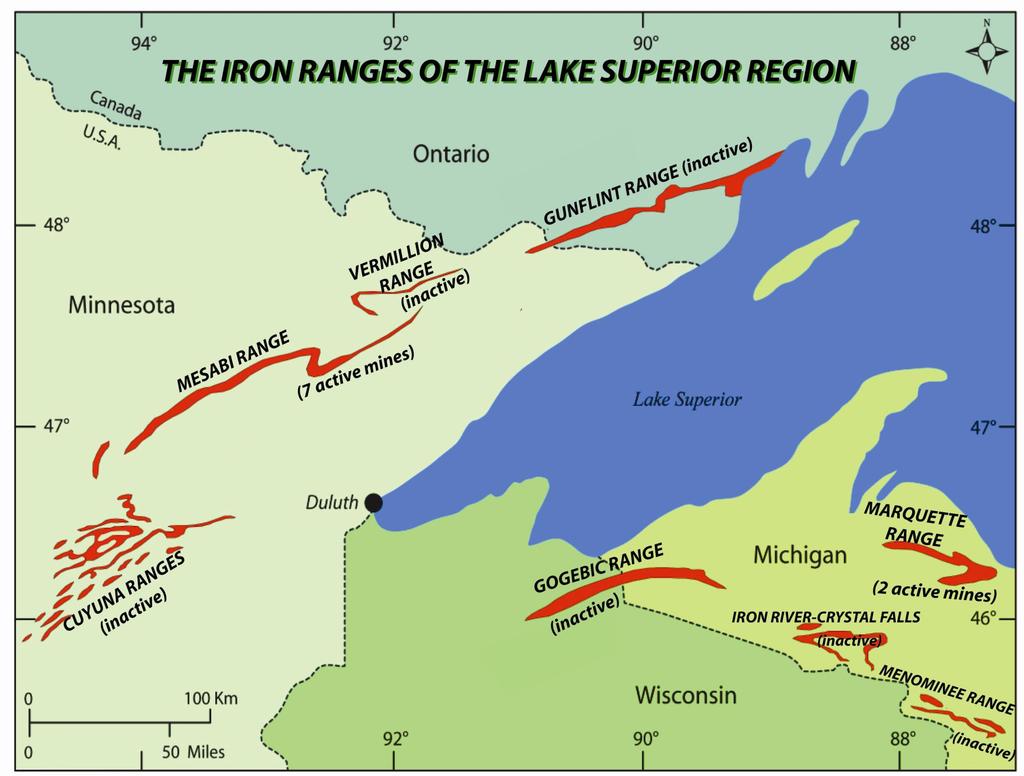
5 MINING HISTORY First ore discoveries and mines: Marquette Range, Michigan: Ore discovered 1844, first ore shipment 1852 Menominee Range, Michigan: Discovered 1846, first mine 1870 Gogebic Range, Michigan and Wisconsin: discovered 1848, first mine 1884 Iron River, Michigan: discovered 1851, first mine 1881 Vermillion Range, Minnesota: discovered 1882, first mine 1884 Mesabi Range, Minnesota: discovered 1866, first mine 1890 Cuyuna Range, Minnesota: discovered 1904, first mine 1910
6 A BRIEF HISTORY OF MINING PHASE 1. The initial phase of mining, from discovery until the 1950 s, was for direct shipping ore (also called natural ore). These ores were pockets of high grade iron concentrations that formed within banded iron formations by leaching of silica by surface water or deeply circulating ground water. PHASE 2. Beginning in the late 1950 s a transition from direct shipping ore to taconite production began. Within a decade it supplanted direct shipping ore. Taconite is produced from metallurgically favorable parts of banded iron-formation and requires concentration and pelletizing at the mine site. PRESENT AND FUTURE. Two new developments are in progress. Production of iron nuggets, essentially pig iron, has begun at one operation in the Mesabi Range. Nuggets can supplant the need for blast furnaces at steel mills. Also on the Mesabi Range, a fully integrated mine-to-steel mill is under construction and will be the first self contained ore-to-steel operation.


7 DIRECT SHIPPING ORE Most commonly soft, earthy material consisting of iron oxides and hydroxides Can be shipped directly to steel mills with little or no processing Can be mined both underground and from open pits

8 TACONITE That part of banded iron-formation for which adequate amounts of contained iron minerals can be extracted to achieve a recovery percentage of 20-25% iron Production is entirely from open pit mines. Production involves mining, crushing, grinding, concentrating, pelletizing and fire-hardening of pellets. All current production, and probably all future production in the Lake Superior region will be from taconite. A common feature of all taconite mines they re big. Includes large open-pit, mill, waste piles, and tailings basins.
9 WHAT IS TACONITE MADE OF? Ore minerals: mostly the iron oxide minerals-- magnetite and hematite. In some places (not in the Lake Superior region) iron carbonates Waste minerals (tailings): a wide variety of silica (chert, jasper), iron carbonate minerals, iron silicate minerals, in places small amounts of sulfide minerals.

10 Gogebic Range


11 Mesabi Range

12 Marquette Range

13 A MESABI RANGE TACONITE PIT


14 Empire and Tilden Mines Marquette Range

15 Empire and Tilden Mines and tailings basins

16 HAULING ORE FROM PIT TO PRIMARY CRUSHER

17 Empire Pit and taconite plant

18 Taconite pellets (each about ½ inch)
19 Pellet stockpile awaiting shipment

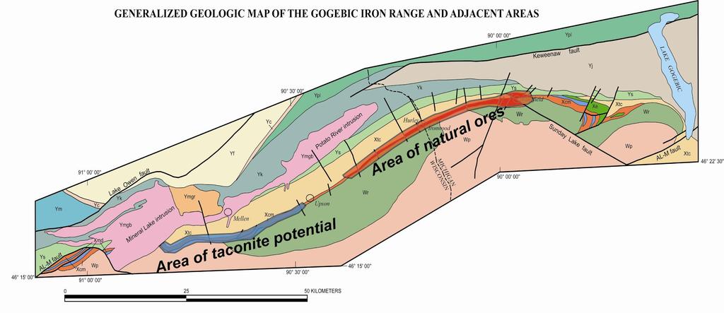
20 TACONITE MINING IN WISCONSIN Jackson County Iron mine near Black River Falls operated from 1969 to JACKSON MINE

21 THE JACKSON COUNTY MINE DURING PRODUCTION

22 Lake Wazee Recreation Area, the reclaimed open pit, tailings basin, and mill site of the Jackson mine
23 LET S FOCUS ON THE GOGEBIC RANGE

24 William F. Cannon, Gene L. LaBerge, John S. Klasner, Klaus, J. Schulz USGS Professional Paper 1730 Available as a free downloadable PDF from USGS web site
25
26
27 IRON ORES 325 million tons of natural (soft) ore was mined from about 40 individual mines on the Gogebic range between 1877 and The natural ores occurred in a 40 kilometer-long segment in the central part of the range spanning the Michigan-Wisconsin border. 3.7 billion tons of concentrating-grade iron-formation (taconite) in the western part of the range was estimated to be profitably mineable from open pits under the economic and technologic conditions of the 1970 s. This is the largest undeveloped iron resource of the Lake Superior region. Vastly greater amounts of geologically similar material also occur in down-dip extensions. The easternmost part of the range also has potential for taconite development but is much less well studied and quantified.

28 The Gogebic is much like the Mesabi Range except that it s turned on end a very important factor in taconite mining.
")
29 The natural ore body at the Puritan Mine (redrawn from Hotchkiss, 1919)
30 POTENTIAL TACONITE MINING ON THE GOGEBIC RANGE The potential has been known for many years. The area was studied intensively by United States Steel in the 1950 s including detailed mapping, drilling, trenching, geophysical studies, and metallurgical testing. An estimate of reserves was commissioned by the U.S. Bureau of Mines in the 1970 s which estimated that there were 3.7 billion tons of economically mineable taconite in the western part of the range. There was little economic interest for many years, but now

31 Statements from Gogebic Taconite official website More than 2 billion tons of estimated ore. Hold lease on 22 mile segment of the range. First phase will focus on 4 to 5 mile segment east of Mellen, Wisconsin Estimate mine lifetime is 35 years. 700 direct mining jobs and about 2,800 total jobs.

32
33

34 COMPLEX FOLD STRUCTURES WITHIN THE IRONWOOD IRON- FORMATION IN THE WESTERN PART OF THE GOGEBIC RANGE
35
36 FOLDING IN THE WESTERN PART OF THE RANGE IS LIKELY TO COMPLICATE THE SIMPLE PIT PLAN USED FOR PREVIOUS RESERVE ESTIMATES

37 The Gogebic Range from Mt. Whittlesey the view is a bit hazy.