Voluntary Water Quality Conservation Plan
|
|
|
- Joella Norton
- 5 years ago
- Views:
Transcription


1 Voluntary Water Quality Conservation Plan Plan Table of Contents A. Mid Coast Agricultural Water Quality Management Area Rules and Plan Overview B. Landowner Resource/Practice Inventory C. Recommended Conservation Practices D. Detailed Plan and Alternatives E. Project Expense F. Timeline, Activity Plan and Financial Assistance Plan Developed By: Lincoln Soil and Water Conservation District Watershed Technical Specialist Joshua Lambert Date A. Oregon Mid Coast Agricultural Water Quality Management Area Rules and Plan Overview In Oregon, water is a public resource. Every Oregon watershed has an Agricultural Water Quality Management Area and Plan. Oregon is divided into multiple Basin Areas. Each Basin Area has an Area Plan which provides information about an Area s water quality, Area rules, and a list of conservation practices that agricultural landowners can employ to help protect our shared public resources. Lincoln County falls within the Mid Coast Agricultural Water Quality Area (see map to the right). Major stream, lake and river water quality concerns identified for the Mid Coast Management Area are: Increased Temperature (from impacted riparian areas) Fecal Coliform (from livestock and human septic) Lower Dissolved Oxygen (from excess nutrient run off) Streambed Sedimentation (from stream bank and road erosion) Loss of biological diversity from aquatic weeds or algae Mid Coast Regulations require agricultural landowners to: Establish and develop sufficient vegetation along stream banks for stream shading, bank stability, and filtration of potential pollutants from overland flows. Prevent pollution of ground or surface water from discharging (livestock or human) wastes or placing any wastes in a location where they are likely to enter groundwater, canals, ditches, or rivers. The regulations allow landowners flexibility in how they protect water quality. They describe conditions that landowners must achieve and maintain on agricultural lands, rather than practices they must implement. Landowners choose practices that will work for them while complying with the law. Lincoln SWCD can provide technical and financial assistance to help landowners implement conservation on their property.
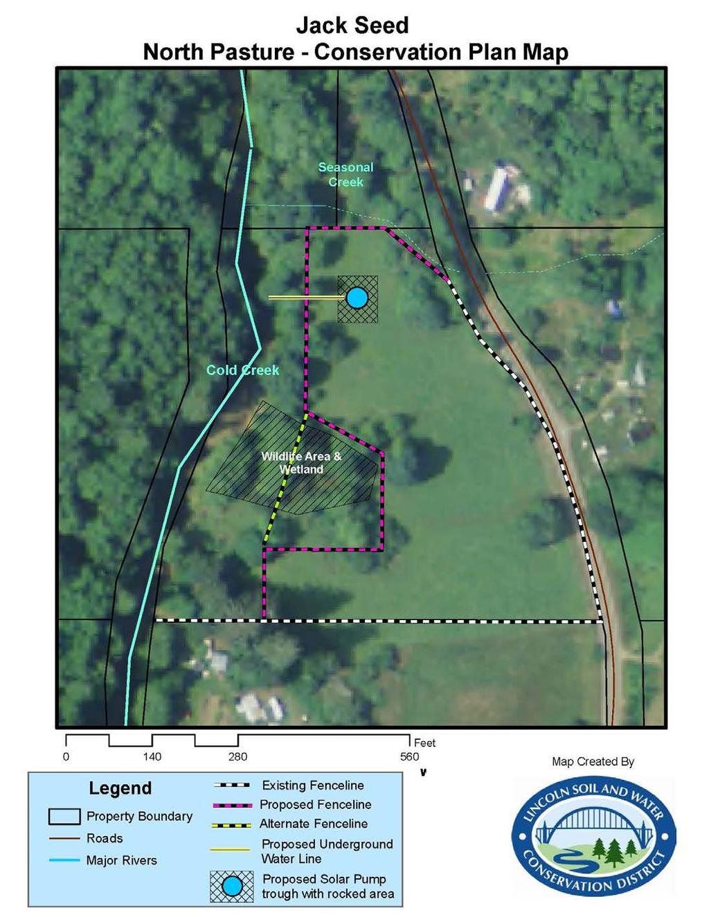
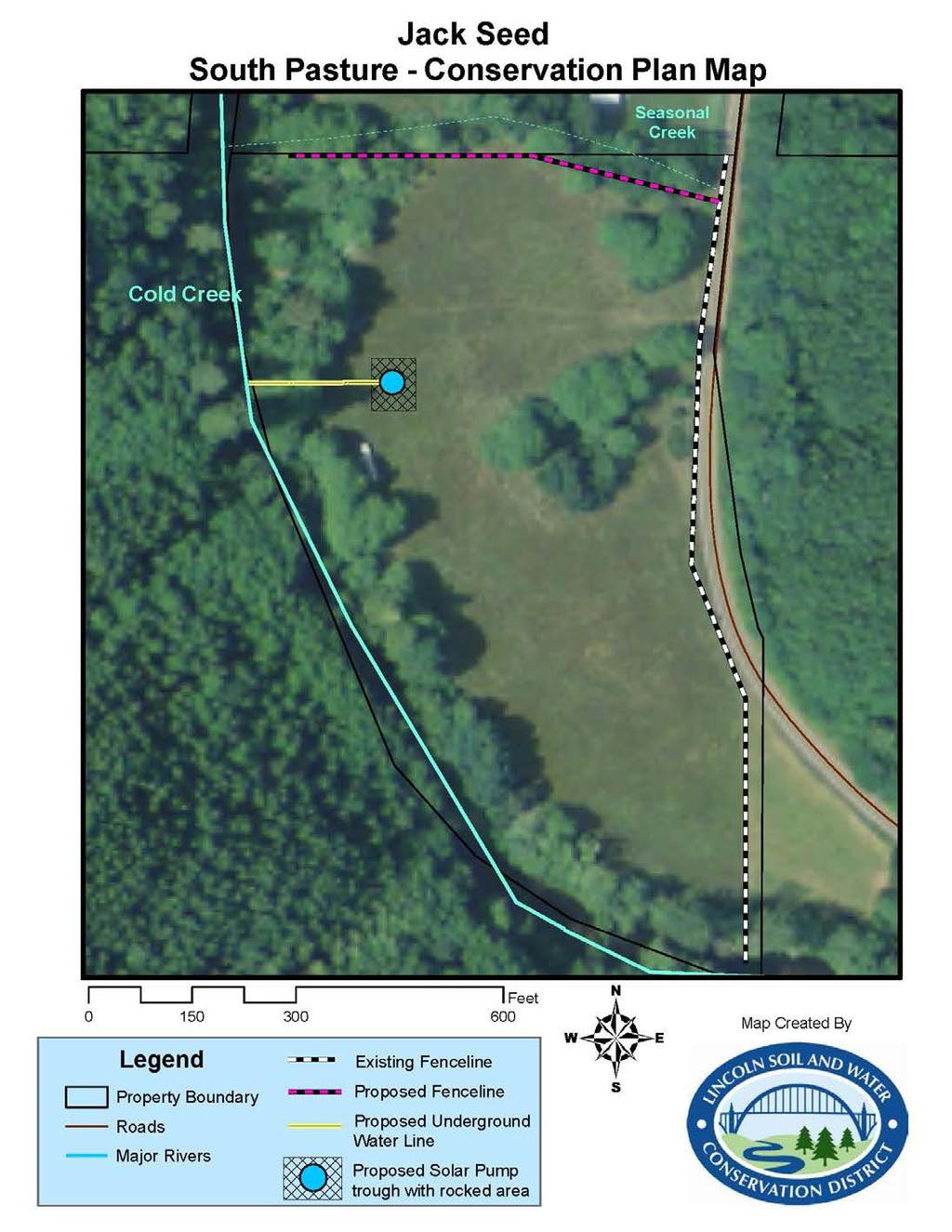
2 B. Landowner Resource Inventory 1. Landowner Information Property owner Jack and Maria Seed Primary Contact Jack Seed Mailing Address Hilltop Rd Site Address if Different N/A Home Phone Primary Contact Phone same as above Legal Taxlot(s) xx-xx-xx-xx-xxxx-xx (North Pasture) xx-xx-xx-xx-xxxx-xx (South Pasture) 2. Landowner Management Objectives Site Visit May 2 nd 2013: Discussion with Jack and Maria Seed. They stated that maintaining pasture and cattle was important to family values and finances. Protecting natural resources like water quality was stated as important. 3. Water Resource Inventory Water resources found within agricultural areas of your property: Stream Name Length (ft) Water Quality/Quantity Concerns Cold Creek ~ 2090ft 303(d) listed for Temperature and Sediment impaired Unnamed seasonal creek North Pasture ~ 380 ft Cattle impact; bacteria, sediment Unnamed seasonal creek South Pasture ~ 740 ft Cattle impact; bacteria, sediment Wetlands North Pasture ~17,400 square feet 4. Land Use Inventory Total Acres Owned 73.5 # Acres in this Plan 19.9 Land Use in this Plan: Location Use Acres Resource Concerns North Pasture Pasture 4.70 North Pasture Riparian Forest 1.60 Cattle impact, sediment and bacteria source to Cold Creek North Pasture Woodland 0.40 North Pasture Wetland 0.40 Wildlife Protection North Pasture Seasonal Stream/Wetland 0.16 Cattle impact, sediment and bacteria source to Cold Creek South Pasture Pasture 10.15
3 South Pasture Riparian Forest 2.73 Cattle impact, sediment and bacteria source to Cold Creek South Pasture Woodland 1.24 South Pasture Seasonal Stream/Wetland 0.20 Cattle impact, sediment and bacteria source to Cold Creek 5. Pasture Inventory/Management Location Soil Type Plants General Condition North Pasture 15B: deep, well drained silt loam; 16C: deep, well drained silt loam Pasture grasses and alder woodlands within pasture Not assessed South Pasture 16C: deep, well drained silt loam Pasture grasses and alder woodlands within pasture Not assessed Soil Type is derived from USDA Soil Survey of Lincoln County Area, Oregon, July 1997 Soil Testing Is there a recent soil test? yes _x_ no N/A Location Date Results (phosphorus, potassium, ph, nitrogen) Agricultural Amendments Are fertilizers or pesticides used in land management? yes _x_ no N/A Location Amendment Rate/Acre Purpose Date Applied 6. Livestock Inventory and Management Location Type Number Days Annually Held Management North and South Pasture Beef cattle Twice annual rotation between North and South Pasture; no additional feed provided Is the operation permitted as a Confined Animal Feeding Operation (CAFO)? yes _x_ no Notes: Is there a livestock management or prescribed grazing system or plan? yes no N/A Notes Is there a manure management system or plan? yes _x_ no N/A Notes
4 7. Woodland Inventory and Management Woodland management is not applicable to this Plan Location Forest Type Age Management 8. Water Supply Sources of livestock water supply: Source of irrigation water supply: direct stream access N/A 9. Monitoring and Water Quality Limited Streams Along Property Clean Water Act 303(d) listed stream(s) along property? _x_yes no Is there a TMDL* issued on 303(d) listed stream(s) along property? yes _x_no Stream Name Length (ft) Water Quality/Quantity Concerns Cold Creek ~ 2090ft 303(d) listed for Temperature and Sediment * TMDL (total maximum daily load) are regulatory defined reductions (quantitative or qualitative) of specified types of water pollution required on water bodies designated as impaired (not meeting Oregon State water quality standards), by the Oregon Department of Environmental Quality and mandated by the Federal Clean Water Act. 10. Natural Resources Location Resource Condition Management North and South Pasture Mature Riparian Forest Good condition Limited grazing, cattle water source access North and South Pasture Seasonal Stream Forest Good condition Limited grazing, cattle water source access North Pasture Wetland degraded condition Limited grazing, cattle water source access 11. Current Plans/Contracts No known federal or state contracts/easements exist with landowner.
5 C. Recommended Conservation Practices Voluntary Water Quality Conservation Plans (from here out Plan) provide landowners with a list of recommended conservation practices that will address specific impacts on water quality from their agricultural operation, meet their goals for a viable agricultural operation and meet the intent of Oregon Department of Agriculture water quality rules as described in the Mid Coast Agricultural Water Quality Management Area Plan (contact Lincoln SWCD for a copy of this plan). Conservation practices must meet technical standards acceptable to the Federal Natural Resource Conservation Service (NRCS), the US Clean Water Act and the Oregon Watershed Enhancement Board (OWEB). Ultimately, if utilized throughout the Mid Coast area, these practices can address the leading causes of water quality impairments found in Lincoln County and the Mid Coast Basin agricultural lands which include temperature, sedimentation, bacteria, etc. The following checked areas are conservation practices that were recommended to you within this plan: Natural Resource Management (examples) Riparian Forest Buffer Enhancement (plant trees and shrubs for shade and stabilization) In-stream Habitat Enhancement (log placement for salmon habitat enhancement) _x_ Livestock Use Exclusion Fence (fence off sensitive areas like wetlands and streams) Streambank Protection (wood structures, bank sloping and planting to stop erosion) Wildlife Wetland Habitat Enhancement Wetland Restoration Wetland Protection Agricultural Resource Management Animal Waste Management Plan Animal Waste Storage Facility Grazing Prescription Pasture Management Stormwater Runoff Management _x_ Offstream Livestock Watering Instream Livestock Watering _x_ Heavy Use Protection Area Filter Strip (examples) (appropriate storage and field application of manure) (covered manure storage shed) (rotational grazing strategies) (best animal/pasture ratio and feeding requirements) (gutters and diversions for barns and manure sheds) (pumps and storage, wells) (gravel hardened stream bank) (gravel hardened area) (grassed area to filter nutrient runoff) Other Practices Upland Wildlife Habitat Enhancement Alternative Energy Systems (increase farm efficiency)
6 D. Detailed Conservation Plan and Alternatives Recommended Plan: please see Plan Maps for practice locations Area Practice Resource Benefit North Pasture; South Pasture Seasonal Stream Exclusion Fence 1. Reduce mud/sediment, bacteria and nutrients from entering Cold Creek North pasture Riparian Exclusion Fence 1. Reduce mud/sediment, bacteria and nutrients from entering Cold Creek 2. Reduce chance of injury to cattle accessing Cold Creek North pasture Wetland Exclusion Fence 1. Protect wetland for wildlife and maintain as filtration for pasture nutrient overflow North Pasture; South Pasture North Pasture; South Pasture Off Stream Water (pump directly from Cold Creek to watering troughs, using solar pump and buried water line or alternative system) Heavy Use Area around water stations 1. Provide clean source of water to cattle within the pasture 2. Increased grazing time/production 3. Reduce chance of injury to cattle accessing Cold Creek 1. Protect pasture area around water stations from mud accumulation Watershed Technical Specialist Comments: Maintenance of direct stream pumps requires seasonal maintenance and likely financial investment to: 1. Ensure pump intake is clear from stream material following high flow events, 2. Ensure pump is properly placed during low water events, 3. Maintain solar pump infrastructure from cattle damage and weathering, 4. Replacement or rebuild of pumps every 3-10 years depending upon usage and quality of pump. 5. Heavy use area gravel wears down over time with usage. Proper function requires fresh rock occasionally. Alternative Plan: To reduce costs associated with fencing, the North Pasture riparian fence could be routed through wetland to cut out approximately 256 ft of fence line while still leaving 70ft buffer between pasture and Cold Creek. The total fence installation in the North Pasture would be 890 ft.
7 E. Estimated Project Expense The below cost estimates are meant to provide a landowner an idea of the financial scope of the recommended practices. In most cases, Lincoln SWCD can secure grant funding to pay for most or all recommended project costs if the landowner is unable to contribute cash. Landowner contributions are highly encouraged and can be in the form of providing skilled labor or equipment (an excavator or tractor) to install project practices, purchase or provide materials, provide actual cash or commit to maintenance of the installed project. Estimated Cost of Practices: Practice Estimated # Units Estimated Rate/Unit Seasonal Stream Exclusion Fence Riparian and Wetland Exclusion Fence Off Stream Water (pump directly from Cold Creek to watering troughs, using solar pump and buried water line) Heavy Use Area around water stations Total Estimated Cost North Pasture ft of 4 strand barbwire fence $4.50/ft $ ft of 4 strand barbwire fence (8 corners) - ALTERNATE: 646 ft of 4 strand barbwire through wetland ft trench 18 deep/place & backfill ft, 1 pvc pipe - 1, 690 gallon water trough - Solar Pump and array square foot, crushed rock surface material square foot geotextile fabric $4.50/ft $4.50/ft TBD $0.55/ft $220 $2500 Lump sum Lump sum $4030 $2907 TBD $96 $220 $2500 $375 $250 North Pasture Cost Estimate Approximately $9,500 Alternative North Pasture Cost Estimate Approximately $7,550 Seasonal Stream Exclusion Fence Off Stream Water (pump directly from Cold Creek to watering troughs, using solar pump and buried water line) Heavy Use Area around water stations South Pasture ft of 4 strand barbwire fence $4.50/ft $ ft trench 18 deep ft, 1 pvc pipe - 1, 690 gallon water trough - Solar Pump and array square foot, crushed rock surface material square foot geotextile fabric TBD $0.55/ft $220 $2500 TBD $248 $220 $2500 $375 $250 South Pasture Cost Estimate Approximately $7,000
8 F. Timeline, Activity Plan and Financial Assistance 1. Timeline: To be determined 2. Activity Plan: To be determined 3. Financial Assistance: To be determined
9
10