Piloting Crop Watch for South Africa - CW4SA. Clement Adjorlolo David Halbert 21 st April 2016
|
|
|
- Anne Nicholson
- 5 years ago
- Views:
Transcription

1 Piloting Crop Watch for South Africa - CW4SA Clement Adjorlolo David Halbert 21 st April 2016
2 Outline Background on Crop Watch for South Africa The CW4SA System Concept System Functionalities and End-to-End workflows Visualizing Biophysical Parameters Theme Applications: Crop Condition Assessment Crop Monitoring Damage Assessment 2
3 Background on Crop Watch for South Africa This Project is being funded via the UK s International Space Partnership Program (IPSP) The programme aims to show, through developing international partnerships, the additionality that UK satellite and space technology can provide over terrestrial solutions in terms of societal or economic benefits. Project funded under both calls will be used to provide sufficient evidence (in terms of benefits and output) to build a case for a longer term programme in this area. Bearing this in mind, all proposal have to be able to clearly show what output they provide on project completion and what this means in terms of societal or financial benefit Memorandum of Understanding between the UK Space Agency and SANSA. 16 th July 2015 Purpose: (a) to provide a framework for collaborate activities and for reviewing areas of common interest in the civil aspects of space Fields of Cooperation: (h) SANSA and UK Space Agency will facilitate collaboration between South African and UK commercial space organisation to build commercial activities between the nations 3
4 Current Areas of Interest Two areas located in the Free State Bothaville AOI Area of approx. of 64,031 km 2 Harrismith AOI Area of approx. 4,358 km 2 4
5 Overview of the CW4SA System Functionalities and workflows Create fraction of crop area/classification Definition/Extract of region of interest Spatial/temporal compositing Time statistics: Derive map with Min/Mean/Max over a series of images Phenology: Define start/end of seasons from a time-series/historical images Anomalies: Difference of current images (e.g., LAI, FAPAR ) against of historical/previous season/year 5


6 CW4SA production workflow Multi-sensor Visualizing and Estimations 6
7 1. Data Requirements Multitemporal imagery (frequent repeat imaging throughout the growing season) Multisensor data: (DMC-2, SPOT6/7, Landsat8, Sentinel 2, CBERS) High Resolution Data Ancillary Data DMC-2 Spot 6 Landsat 8 Sentinel 2 Spatial Resolution 22m 6m 30m 10/20m Spectral Bands Swath 650km 60km 180km 290km Revisit 5 days 1 day 16 days 10 days 7

8 Overland Developed by Hervé Poilvé at Airbus DS in Toulouse Built with IDL, running on freely available IDL Virtual Machine Used in previous land cover mapping campaigns, as Geoland2 Large number of optical data can be imported: Landsat, DMC, Spot, RapidEye, etc. Biophysical parameters Soil reflectance model used as input to calculate vegetation model. In this case a soil model has been developed from Landsat 8 imagery before growing season In-built atmospheric correction module, based on Lowtran model Large number of biophysical parameters can be selected, like Fcover, Fbrown, LAI, Fsoil, CSF, Fwater XML scripting developed to use Overland in automated processing chain 8
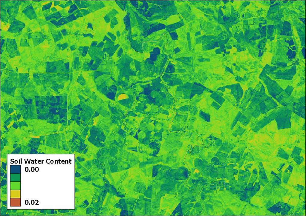
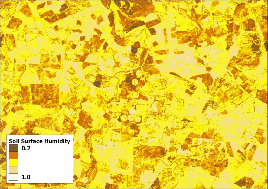
 Green Leaf Area Index Leaf Chlorophyll Content (CHL) Leaf Water Content Soil Brightness Soil Fraction Soil Surface Humidity Soil Water")
9 2, Calculated Biophysical parameters Canopy Shadow Factor Fraction of Absorbed Photosynthetically Active Radiation (FAPAR) Fraction of Brown Vegetation Cover Fraction of Vegetation Cover Fraction of Soil Leaf Area Index (LAI) Green Leaf Area Index Leaf Chlorophyll Content (CHL) Leaf Water Content Soil Brightness Soil Fraction Soil Surface Humidity Soil Water Content 9
10 Overland Outputs 10
11 11
12 12
13 Overland Instructions 13
14 2 & 3 CW4SA production workflow 14

15 4. Visualizing and Estimations Crop Watch for South Africa Harrismith - site 15
16 Crop Monitoring & Assessment Crop Type Identification and Mapping Crop Condition Assessment Crop Monitoring Crop area estimation Crop growth monitoring Crop yield forecasting Damage/Stress Assessment 16

17 Field Crops Monitoring 17
18 Current Areas of Interest Two areas located in the Free State Bothaville AOI Area of approx. of 64,031 km 2 Harrismith AOI Area of approx. 4,358 km 2 18

19 Fraction of crop area Harrismith-site: ~4069/8757 Fields planted: October 2015 to March

20 Visualizing Crop Stress and Estimation Recovered Water DEMO Stress Zones 20

21 CW4SA production workflow 21


22 Farm Level Crop growth monitoring Management Options and the Need for a Stress-factor Crop Watch for South Africa Harrismith 22


23 Modelling LAI,FAPAR & ET (evapotranspiration) Actual ET calculated from Landsat-8 data acquired over centerpivots irrigated corn field near Harrismith. Image date:


24 CW4SA Products (LAI,FAPAR & ET) Validation work is ongoing
25 Any Questions? 25