Appendix M Part 1. Wetland Reserve Program. U.S. Army Corps of Engineers Memphis District
|
|
|
- Melvin Bishop
- 5 years ago
- Views:
Transcription

1 Appendix M Part 1 Wetland Reserve Program U.S. Army Corps of Engineers Memphis District
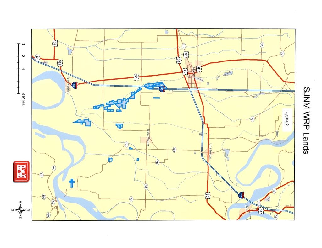
2 St. Johns Bayou and New Madrid Floodway (SJNM) Project Wetlands Reserve Program (WRP) Introduction: The Wetlands Reserve Program is a voluntary program offering landowners the opportunity to protect, restore, and enhance wetlands on their property. The USDA Natural Resources Conservation Service (NRCS) provides technical and financial support to help landowners with their wetland restoration efforts. The NRCS goal is to achieve the greatest wetland functions and values, along with optimum wildlife habitat, on every acre enrolled in the program. This program offers landowners an opportunity to establish long-term conservation and wildlife practices and protection. The WRP has been successful in restoring lands within the St Johns Bayou and New Madrid Floodway Project (SJNM) area. This has resulted in cropland being converted to other wetland uses. This trend could continue over the expected life of the SJNM Project assuming adequate Federal funding for WRP. Because of this estimates of potential future conversions had to be made to use for project impact purposes. A set of assumptions was developed and a projected timeline established. All assumptions, methodology, and resulting timeline were coordinated with and reviewed by NRCS. The following sections describe the assumptions and methodology. Trends in WRP lands: An analysis of data obtained from the NRCS GIS Spatial database reveals that over the past 15 years approximately 5,800 acres of cropland have been converted to WRP lands within the SJNM project area. This is a trend of approximately 155 acres per year. Most of the WRP lands (approximately 77%) have been developed within the St Johns Bayou Basin. Of these lands 94% (4,435 acres) have occurred along St Johns Bayou. While the majority of the sites are south of highway 80, a significant portion of the WRP lands in the St Johns Basin (1,256 acres) are located north of highway 80 outside of the more frequently flooded sump area. Figures 1, 2, and 3 show the actual locations of the WRP lands. If this trend continues, future WRP lands should be expected to be developed mostly along St Johns Bayou. A very large portion of the land along lower St Johns Bayou below Highway 80 is already in woods or WRP. Therefore, absent changes in conditions that could cause tracts farther from St Johns Bayou to be offered, the potential for additional WRP lands is low in this reach below Highway 80. It is anticipated that most of the future development of WRP lands would be above highway 80. Table 1 presents the expected increase in WRP for the St Johns Basin. Over the next 50 years an additional 2,900 acres of WRP is projected to be developed for a total of about 7,400 acres (Table 2) in the St Johns Basin.
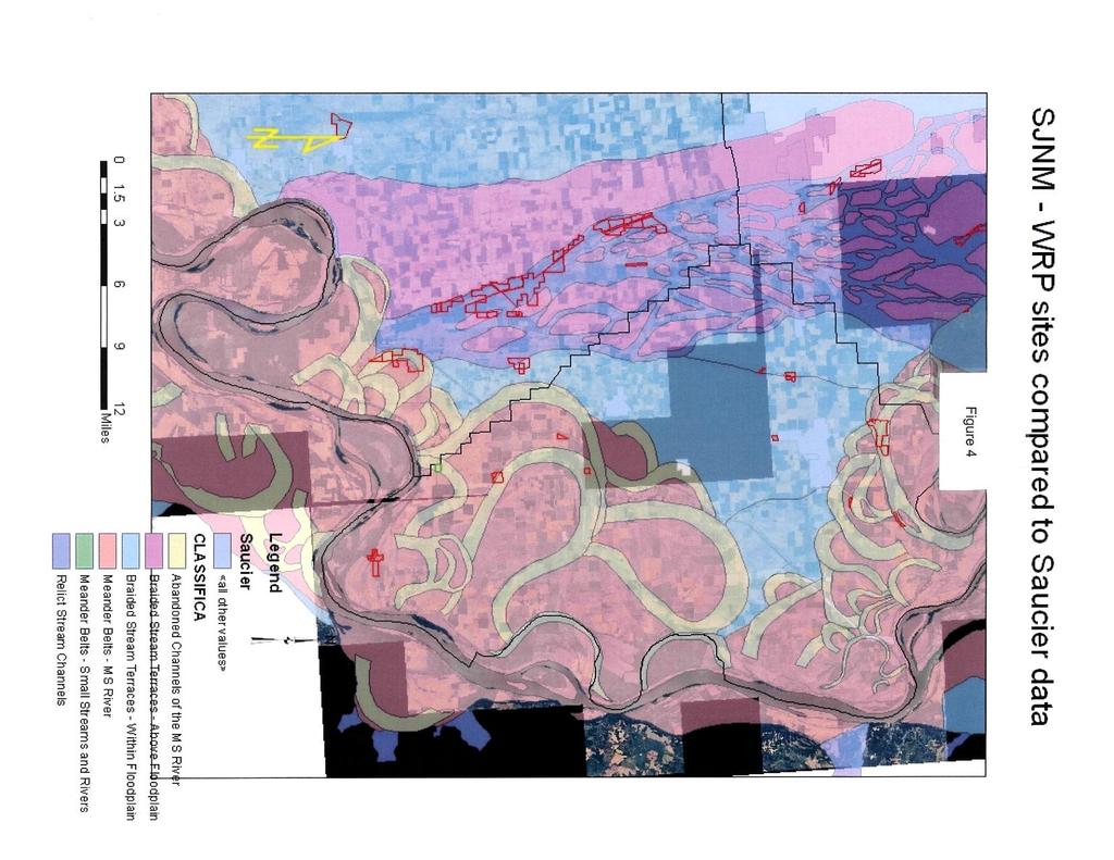
3 In the New Madrid Floodway, WRP has not been as prevalent. This could possibly be due to soil type as well as flood characteristics. The soil type in the lower New Madrid Floodway is a heavier clay type that is much more productive. The headwater flooding problems are also not as much an issue since the Floodway is a totally surrounded by levees which results in a smaller more defined drainage basin. NRCS has indicated that the use of Saucier soils data when restoring sites in the area indicate that the majority of WRP sites located within the St Johns Bayou Basin are in the old relic stream channels as formed by the meanderings of the Mississippi River. These typically are of a more clay and silt content and are characteristically wetter soils. These areas are commonly referred to as valley trains and typically are well suited for wetland restoration. Other WRP sites, when compared to Saucier soil data, located outside of the St Johns Bayou Basin are within old abandoned river channels. Again, these areas are typically more clay and silt and wetter type soils and are good wetland restoration sites (Figure 4). A trend line analysis of the past 15 years of data shows that another 900 acres of WRP could be developed in the Floodway (Table 1). It is expected that areas by the levees in the project area would be targeted. Areas by the Mississippi River levee could be targeted because of seepage problems which cause the fields to be too wet to be profitable during high Mississippi River levels. Areas by the Setback levee could be targeted due to borrow pits and old drainage ditches or sloughs that were left during construction of the Setback levee. Over the next 50 years an additional 900 acres of WRP is projected to be developed for a total of about 2,200 acres (Table 2) in the New Madrid Floodway. There were several assumptions made when trying to estimate future WRP lands over the next 50 years. These are listed below. In is noted that due to current Federal budget problems, it is very difficult to project growth in a program that is dependent on future Federal appropriations. In all, it is estimated that an additional 3,800 acres of WRP lands may be developed in the general project vicinity for a total of 9,600 acres (Table 2). Assumptions Used for Projecting WRP Lands in Project Area: 1. Much of the increase in WRP lands is located out of the backwater or sump area. Of the total 4,435 acres in the St Johns Bayou Basin, 1,256 are located above Hwy The increase in WRP lands within the St Johns Basin appear to be influenced more by headwater flooding than by backwater flooding. 3. It appears that the increase in WRP along St Johns Bayou is also influenced by soil type. Much of the land appears to be wetter, less productive with lower yields due to factors other than flooding. 4. Most of the WRP lands are located along St Johns Bayou, 4,164 of 4,435 or about 94% of the WRP acreage in the St Johns Bayou Basin. 5. Very little of the WRP lands are located in the New Madrid Floodway 1,346 acres.
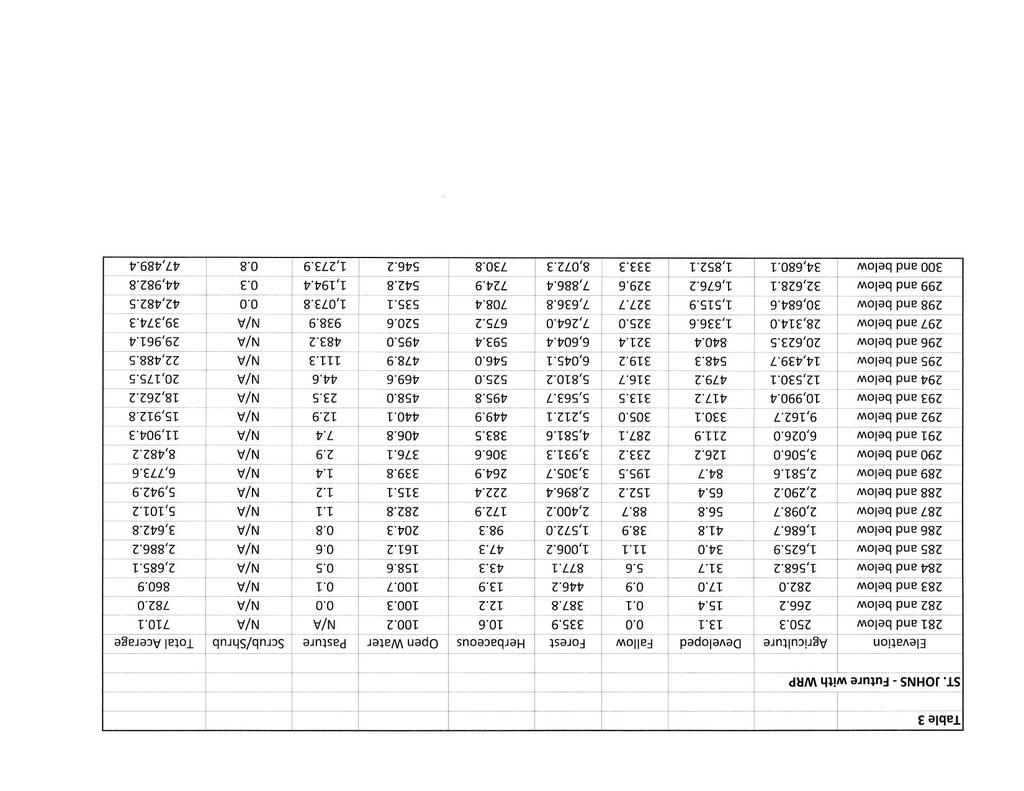
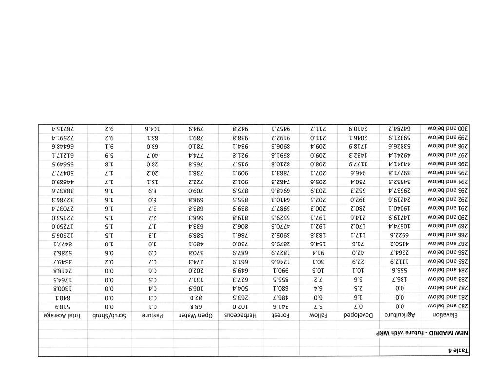
4 6. The WRP lands located in the Floodway appear to be influenced by seepage from the Mississippi River during high river stages and soil types which are wet and hard to farm. They also appear to be influenced by construction activities associated with construction of the Setback levee for the Birds Point-New Madrid Floodway Project. 7. Over the past 15 years WRP lands in the project area have increased about 155 acres per year. 8. Prorating the 155 acre increase per year between the basins yields an increase of about 36 acres per year in the New Madrid Floodway and 119 acres per year in the St Johns Bayou Basin. 9. The trend in the project area in the lower St Johns Bayou Basin can probably not be sustained as targeted areas along St Johns Bayou Basin are converted. All additional WRP lands south of Hwy 80 are expected to occur within 10 years. Any further increases are expected to be along St Johns Bayou upstream of the project area (north of Hwy 80). 10. The trend in WRP lands can probably be maintained in the New Madrid Floodway with an increase of approximately 900 acres after 25 years and remain constant thereafter. 11. Future WRP lands in the Floodway are projected to be located in wet areas along the Mississippi River levee within seepage areas, along the Setback levee, and in old Mississippi River scars. NRCS may start targeting best suited priority areas per data like Saucier in the future to assure quality sites are enrolled. 12. These trends can only be sustained with continued WRP funding levels. Current Federal budget difficulties could cause these trends to slow. Because of these difficulties projections were made for 25 years with levels remaining constant for later years. 13. Agricultural prices have been very unfavorable for WRP conversion in the last year or two. Higher agricultural prices have caused crop production to be more profitable. If this trend continues the rate of WRP conversion should slow. 14. Voluntary programs such as the Migratory Bird Habitat Initiative will help to ensure existing WRP sites are maintained to ensure they perform as originally designed. Future WRP Projections /Adjusted Stage Area Curves: USACE assumed a linear relationship for acres enrolled at a 1-foot elevation contour, as well as, a linear relationship with the type of land cover (70% forest, 20% herbaceous, 10% open water based on feedback provided by NRCS). For planning purposes, it was assumed that the lower elevation lands would be enrolled in WRP first; then, the available lands at the next higher elevation until all projected WRP were accounted. Adjusted stage area curves were developed for the St. Johns Basin (Table 3) and New Madrid Floodway (Table 4) to reflect projected future WRP lands.

5
6
7
8
9 Table 1 Projected Increase in WRP Lands St Johns Bayou and New Madrid Floodway Area Present (2010) Acres /Year Years in Future Floodway Bayou Basin Below Hwy 80 Above Hwy 80 Total 1, , ,100 1,700 2,300 2,900 2,900 3, , ,500 2,100 2,100 5, ,500 2,300 3,100 3,800 3,800 Table 2 Total WRP Lands (Actual Acres with Projections) St Johns Bayou and New Madrid Floodway Area Present (2010) Acres /Year Years in Future Floodway Bayou Basin Below Hwy 80 Above Hwy 80 Total 1, ,700 1,900 2,100 2,200 2,200 4, ,600 6,200 6,800 7,400 7,400 3, ,000 4,000 4,000 4,000 4,000 1, ,600 2,200 2,800 3,400 3,400 5, ,300 8,100 8,900 9,600 9,600
10
11