GEOGLAM Global Agricultural Monitoring
|
|
|
- Brent Harper
- 5 years ago
- Views:
Transcription


1 GEOGLAM Global Agricultural Monitoring Dr. Selma Cherchali on behalf of the GEOGLAM Crop Monitor team Land and Hydrology Program Manager Science, Application and innovation Directorate, CNES Co-Lead, CEOS - GEOGLAM AdHoc group, selma.cherchali@cnes.fr With the contribution :Michel Deshayes 2, Alyssa Whitcraft 3 2 GEOGLAM Coordinator, mdeshayes@geosec.org 3 GEOGLAM Secretariat, CEOS liaison, awhitcraft@geoglam.org
, 1980/81 to 2010/11, base 100 in 1980/81; Source: INRA from USDA/PSD and FAOSTAT data Selma Cherchali, Workshop Agriculture and Earth Observation July 5 th, The Hague,")
2 Challenge : Feeding the planet Yields World Cereals Production World Population Cropland area World population and World area, yields and production in cereals (including rice), 1980/81 to 2010/11, base 100 in 1980/81; Source: INRA from USDA/PSD and FAOSTAT data Selma Cherchali, Workshop Agriculture and Earth Observation July 5 th, The Hague, /18
3 Recent volatility of Agricultural Prices Monthly Wheat Prices ($/Metric Ton) Source: World Bank 2010/11 Price hikes Drought: Russia 2008 Price hikes Droughts: Australia & Ukraine Landsat 1 Launched (1972) 1971/2 s price hike Drought: Russia Average Price : 150$ Average Price : 75$ Average Price : 300$ Nominal wheat price in US $/metric Ton Selma Cherchali, Workshop Agriculture and Earth Observation July 5 th, The Hague, /18


 GEOGLAM :")


4 G20 Agriculture Priority, Nov AMIS & GEOGLAM Two initiatives to increase information availability, quality and transparency : AMIS : improve information on markets (FAO) GEOGLAM : improve information on supply (GEO) Supply Prices Demand Policies Finance Stocks Trade AMIS UNITED NATIONS HLTF Food Security World Bank Selma Cherchali, Workshop Agriculture and Earth Observation July 5 th, The Hague, /18 4/19


5 Policy Framework for GEOGLAM: 2011 & 2016 Selma Cherchali, Workshop Agriculture and Earth Observation July 5 th, The Hague, 2017

6 GEOGLAM Objectives To strengthen the international community s capacity to produce & disseminate relevant, timely and accurate information & forecasts on agricultural production at national, regional & global scales, through reinforced use of Earth Observations GEOGLAM is a «coordination programme», aiming at - supporting, strengthening and articulating existing efforts - developing capacities and awareness at national & global level - disseminating information 6/XX
7 GEOGLAM Achievements 1. Crop Monitor for AMIS


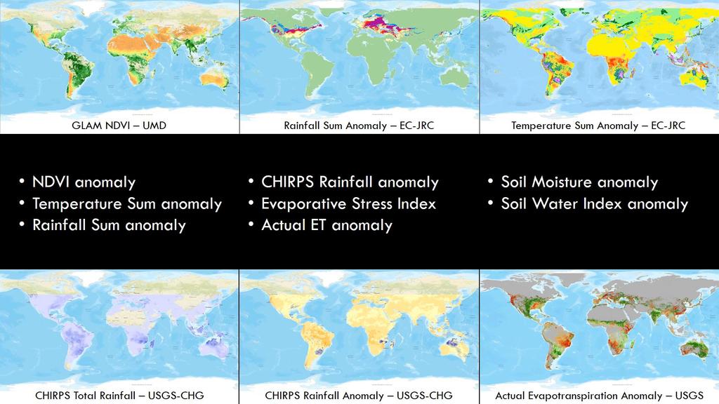
8 GEOGLAM Crop Monitor for AMIS (1/2) Crop Monitor for AMIS: operational since Sept. 2013! 39 institutions (17 countries + EC + 8 intern. org., leader: Univ. Maryland) A presentation of results with graphics and text (1/3) a. a global map for the 4 AMIS crops End of of August 2016 Maize Crop Conditions + a global map, with drivers, for each crop 8/19
 A presentation of")
 Rice Production End")


9 Achievements GEOGLAM Crop Monitor for AMIS (2/2) A presentation of results with graphics and text (cont ) Rice Production End October 15 c. 4 synthetic pie-charts sectors proportional to countries average share of world production colors according to local crop conditions symbols to explain reasons for bad conditions Wheat Rice Export End October 15 (on Crop Monitor Website) Maize Soybean 9 9/19


10 Becker-Reshef et al. EO allows synoptic, quick detection of crop crises Use of NDVI, Normalised Difference Vegetation Index : Red - InfraRed NDVI = Red + InfraRed August 13th 2012 Canada USA Ukraine Russia Kazakhstan China Non Cropland Not shown NDVI tracks crop growth can indicate condition India Better than average anomaly Average normal year NDVI Profile No change on-going year Worse than average
11


12 Crop Monitor is an integral part of the AMIS Market Monitor GEOGLAM became the 11 th member of the AMIS Secretariat in 2016 First time the international community comes together to produce operational crop assessments with 40 contributing organizations & Ministries of Agriculture Strong collaboration between GEOGLAM and AMIS Bridging the gap between the Earth Observations and Economics communities Crop Monitor operational since 2013
13 GEOGLAM Achievements 1. Crop Monitor for AMIS 2. Crop Monitor for Early Warning
, WFP (VAM), USA (FEWSNET), EU (JRC-FS), CN (CropWatch-FS) 83 countries")
14 Crop Monitor for Early Warning (CM4EW) From February 2016, a new bulletin with GEOGLAM partners having Monitoring activities on Countries at Risk : FAO (GIEWS), WFP (VAM), USA (FEWSNET), EU (JRC-FS), CN (CropWatch-FS) 83 countries covered 14/19


15 First Crop Monitor for Early Warning, Feb Consensus Map highlighting the poor conditions in Southern Africa for Maize 1 new condition: Failure 3 more drivers: Pest & Disease Socio-Political Delayed Onset 15/19
16 GEOGLAM Achievements 1. Crop Monitor for AMIS 2. Crop Monitor for Early Warning 3. Global Crop Monitoring
17 Achievements Global Crop Monitoring about 94% of world agricultural area Selma Cherchali, Workshop Agriculture and Earth Observation July 5 th, The Hague, /19
18 GEOGLAM Achievements 1. Crop Monitor for AMIS 2. Crop Monitor for Early Warning 3. Global Crop Monitoring 4. The 2030 Agenda for Sustainable Development SDG#2 End Hunger
19 GEOGLAM Crop Monitors & Economics Information Asymmetry (IA) theory IA Theory: study of decisions in transactions where one party has more or better information than the other IA consequences : transactions going sometimes awry, with in worst cases market failure From 1970, series of papers by Akerlof, by Spence and by Stiglitz 2001: Nobel Price in Economics awarded to Akerlof, Spence & Stiglitz GEOGLAM and Information (a)symmetry By producing & openly disseminating relevant, timely and accurate information and forecasts on agricultural production GEOGLAM contributes to an efficient functioning of markets. Selma Cherchali, Workshop Agriculture and Earth Observation July 5 th, The Hague, /19

20 SDG-2 End Hunger Goal SDG-2 informed by Crop Monitors By producing & openly disseminating relevant, timely and accurate information and forecasts on agricultural production GEOGLAM fully contributes to SDG Indicator 2.c
21 Global Crop Monitor (UMD) Rangelands & Pasture Productivity (RAPP-CSIRO) 1. Global / Regional System of Systems main producer countries, major commodities EC FP7 SIGMA project Stimulating Innovation for Global Monitoring of Agriculture and its Impact on the Environment in support of GEOGLAM (VITO) Mature / On going Emerging or R&D R&D Past / Finishing Asia-RiCE reporting to GCM (JAXA- ASEAN) Asia-RiCE develop and transfer of methods (JAXA-ASEAN) 2. National Capacity Building for agricultural monitoring using earth observation 4. EO data coordination CB projects in Argentina, Mongolia, Pakistan, Ukraine 5. Method improvement through R&D coordination 6. Data products and information dissemination ESA projects: SEN2-FOR-AGRI (UCL) 4 Agri. Products + Software + 4 Use cases GEORICE (CESBIO) Radar for Rice growth monitoring STARS (BM Gates) Spurring a Transformation for Agriculture through Remote Sensing (ITC-UMD) Crop Monitor for Early Warning 3. Monitoring countries at risk food security assessment GEONetCast Satellite Broadcasting Selma Cherchali, Workshop Agriculture and Earth Observation July 5 th, The Hague, 2017 Close links with Committee of Earth Observation Satellites (CEOS) Joint Experiment for Crop Assessment & Monitoring JECAM (AAFC UCL) Data services prototypes developed/ tested NASA/CEOS SEO

22 GEOGLAM Activities 22/19
23 Ideas and Challenges ahead GEOGLAM implementation at regional level is critical Regional networks share common priorities, confront common challenges: Common cultivars, agricultural systems Can have common impacts of regional climate variability (e.g. El Nino) Challenges with data accessibility (computational infrastructure) Challenges with EO method adoption/use (capacity development) Market connections Strong capacity development focus encouraging South-South transfer Current Regional Networks: Asia-RiCE GEOGLAM Latinoamérica (AmeriGEOSS Food Security & Sustainable Agriculture Working Group) AfriGAM relationship with AfriGEOSS Idea: a Rangeland & Pasture Productivity (RAPP) Monitor for Early Warning Towards a Crop & Rangeland Monitor for Early Warning CRM4EW R&D projects ending, new projects a new era : Sentinels bu not only..mutil-missions Ended: STARS (Gates), Georice Ending soon: EC-SIGMA, ESA-Sen2-Agri, GeoRice Just started: ESA-Food Security TEP (Thematic Exploitation Platform) Recent calls, results expected: China (MOST), USA (ROSES), France (TOSCA), EC (SFS-43) Capacity Development activities Setting up a Directory of existing CD material Objective: a set of e-learning modules, in different languages, accessible online Selma Cherchali, Workshop Agriculture and Earth Observation July 5 th, The Hague, /19
24 Strong and sustained G20 Policy Mandate Achievements Summary Developed a OPEN Community of Practice engaged in achieving the GEO strategic targets for agriculture Attained Flagship Status recognition from GEO Programme Board Developed two global Crop Monitors for AMIS, for Early Warning Opportunities to tailor to national settings Established a network of R&D pilot sites across the globe for developing best practices (JECAM - Joint Experiment for Crop Assessment & Monitoring, supplemented by SIGMA, Sentinel-2-Agri, Asia-RiCE, Georice and BMGF STARS Developed Asia-RiCE, new regional system for Rice Crop Estimation & Monitoring Launch of 2 additional regional networks with strong capacity development component: GEOGLAM Latinoamerica AfriGAM Selma Cherchali, Workshop Agriculture and Earth Observation July 5 th, The Hague, 2017
25 Achievements Summary Developed a set of global baseline datasets (crop masks and calendars; field size) Developed space-based Earth observation requirements CEOS coordination of space-based EO acquisition Prototyped multiple cloud-based and web-enabled EO monitoring systems GLAM, Crop Monitor, ESA Thematic Exploitation Platform, JAXA INAHOR/JASMIN, THEIA Land Data Center, CEOS Data Cube Engaged national governments in developing capacity for incorporating EO into their crop projections system (Argentina, Australia, Mexico, Pakistan, Ukraine ) Coordination with CEOS and space agencies for resource sharing Presented GEOGLAM at high level meetings such as G8 Open Data for Agriculture Established linkages with AgMIP, USDA LTAR/LTER, and other initiatives Contributions to the UN SDGs, with possibility for greater engagement in contributing to, monitoring, and measuring progress Selma Cherchali, Workshop Agriculture and Earth Observation July 5 th, The Hague, 2017
 a fully automatic production system to produce agriculture information from Sentinel-2 data, with a focus on food security applications.")
26 Operational R&D continued New in 2017: JECAM SAR Intercomparison Project Crop biophysical (LAI/biomass) experiment (Heather McNairn) Crop type mapping (Andrew Davidson, AAFC) Sentinel-2 for Agriculture ( a fully automatic production system to produce agriculture information from Sentinel-2 data, with a focus on food security applications. final user meeting was held in Rome at Food and Agriculture Organization and World Food Program develop, demonstrate and facilitate the Sentinel-2 time series contribution to the satellite EO component of agriculture monitoring provide validated algorithms, open source code and best practices to process Sentinel- 2 data in an operational manner for major worldwide representative agriculture systems distributed all over the world. GEORICE : next examples SIGMA Stimulating Innovation for the Global Monitoring of Agriculture ( Identify, map, & assess croplands and agriculture at multiple scales Selma Cherchali, Workshop Agriculture and Earth Observation July 5 th, The Hague, 2017


27 Service concept : Dedicated to the rice monitoring using Copernicus Sentinel-1 data Features : + Rice Map Season rice map + + Crop intensity Phenology


28 Screen shot Comparison between 2 seasons rice maps Selma Cherchali, Workshop Agriculture and Earth Observation July 5 th, The Hague, 2017


29 GEORiCE Rice monitoring using Sentinel-1A data Monitoring of Winter-Spring rice Thap Muoi Long Xuyen Can Tho Vinh Long 100 km x 70 km, 20 m resolution Mekong Delta, Vietnam 300 km x 300 km 20 m resolution Rice: early stage Rice: tillering stage Rice: reproductive stage Rice: maturity stage Non rice (forest, other LULC) Water (ocean, river, aquaculture) Land outside the Vietnam Mekong delta 29/XX
30 Summary & the Way Forward Crop Monitors providing a public good: open, timely, science-driven, actionable information on global crop conditions Already informing decisions Develop a portfolio of a new generation of products (Sentinels, and other and other multisource data): R&D projects Bridging the gap between the policy/econ and EO communities Ensuring user community is driving the satellite monitoring research agenda Increasing communication and knowledge transfer amongst countries and monitoring systems Thereby strengthening national monitoring systems Strong focus on strengthening national partnerships; expanding participation in regional networks and national systems, particularly in countries at risk
31 Agriculture and the Food production Challenges Increase of food production (and reduction of waste and loss) Adaptation to climate change (and contribution to mitigation) Reduction of environmental impacts Fertilizer pollution, soil degradation, unsustainable water use, biodiversity erosion, Reduction of the volatility of commodity prices Improvement of food «quality» (traceability, organic products, ) For which users? Markets and crisis management : Traders, GEOGLAM, WFP Tactical management : precision farming, water management Strategic management : new cropping systems, soil restoration, pest control, water resources, Research : from fundamental processes to operational models Selma Cherchali, Workshop Agriculture and Earth Observation July 5 th, The Hague, 2017


 Bradley.")

")


32 Thank You! Crop Monitor for AMIS Partners Crop Monitor for Early Warning Partners Contacts: (Selma Cherchali, CNES) (Bradley Doorn, NASA HQ) (Inbal Becker-Reshef, Crop Monitor lead, GEOGLAM Secretariat) Follow us (Michel Deshayes) (Alyssa Whitcraft)