CLIMATE CHANGE AND FLOOD RISK IN THE MEKONG DELTA ADAPTATION AND COEXISTENCE IN FLOOD-PRONE RICE AREA
|
|
|
- Carol James
- 5 years ago
- Views:
Transcription
1 CLIMATE CHANGE AND FLOOD RISK IN THE MEKONG DELTA ADAPTATION AND COEXISTENCE IN FLOOD-PRONE RICE AREA Hideto Fujii Japan International Research Center for Agricultural Sciences 1-1 Ohwashi, Tsukuba, Ibaraki , Japan Hideto Fujii is a project leader on JIRCAS s flagship project on climate change as well as a guest professor at Tottori University (in Japan). He has been studying water management in rice cultivation in the tropical monsoon areas of Asia and Africa for 25 years, including (i) water management and the direct seeding of rice in the Muda Irrigation Scheme in Malaysia, (ii) evaluation of the flood-mitigation function in flood-prone areas of the Mekong River in Cambodia, (iii) development of suitable site-selection measures in an inland valley wetland in Ghana, and (iv) water management on cascade tank systems in a dry zone in Sri Lanka. 151
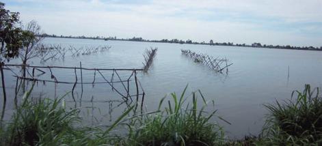
2 Session 3 ABSTRACT Introduction Vietnam is the world s second largest rice exporter, with 90% of rice exports produced in the Mekong Delta region. However, it is being threatened by sea level rise and river flooding. According to the Fourth Assessment Report of the Intergovernmental Panel on Climate Change (IPCC), the densely populated mega deltas in South and Southeast Asia face the greatest risk. To address the report, the government of Vietnam formulated a National Target Program in 2008 to respond to climate change. In it, they acknowledged the need to cope with three key issues saltwater intrusion, flooding, and lack of fresh water as soon as possible. Mekong Delta, whose floodwaters enter Vietnam from Cambodia, is located in a vast network of distributaries at the mouth of Mekong River. Riverine and tidal floods are common, reaching even the upper Mekong Delta plain (inundation levels between 1-3 m). Nevertheless, the area remains active as a rice granary due to its nutrient-rich soils and dense waterways and canals. Two types of dyke systems were constructed to reduce vulnerability in high-flood areas such as An Giang and Dong Thap Provinces adjacent to the Cambodian border: a high embankment called fulldyke, which completely prevents farmland from flooding; and a low embankment called semi-dyke, which prevents flooding up to the summer-autumn rice harvest but allows flood inflow after harvest (Photo 1). Photo 1: Rice cultivation during peak flood (Chau Doc District in An Giang Province) (Left: paddy fields enclosed by semi-dyke; Right: paddy fields enclosed by full-dyke) Triple rice cropping became possible in farmlands enclosed by full-dykes as rice can be grown even during peak flood season (September to November). In response to farmers request, the Vietnamese government made it a policy to construct dykes, hence areas with full-dyke systems expanded rapidly in the past 10 years especially in An Giang and Dong Thap. However, negative impacts caused by preventing floodwater into the farmland and by employing a triple rice cropping system soon became apparent. The current state of the full-dyke system in a flood-prone rice granary area in Mekong Delta is discussed in this article, based on a survey conducted in An Giang where a JIRCAS climate change project is located (Figure 1). Advantages and disadvantages of full-dyke systems The first full-dyke in Chau Phu District in An Giang Province was built in 2001 on a small sandbar along Mekong River, but it was only in 2006 when full-dyke systems began to expand rapidly. Areas covered by full-dyke systems increased from only around 20% in 2007 to more than 80% by There are several advantages and disadvantages of full-dyke systems. Full-dykes protect farmlands from floods throughout the year, allowing farmers to grow and harvest rice up to three times a year. However, it has also been documented that full-dykes have many disadvantages (Table 1). The scale of 152

3 the large flood that occurred along Mekong River in 2011, which caused many full-dykes in An Giang Province to burst, was a scale comparable to that in The upper part of Photo 2 shows the inundated area in Chau Phu District in An Giang caused by the collapse of the full-dyke in The full-dyke was built in 2010 but was destroyed by flood the following year. The damaged area was approximately 110 ha. The collapsed dyke has been repaired by the local government, but the full-dyke system was found to have safety problems. Figure 1: Mekong Delta (left) and An Giang Province (right) Table 1: Pros and cons of full-dyke systems Advantages Disadvantages Realization of triple rice cropping Infrastructure such as roads and settlements as well as agricultural lands are protected from flooding throughout the year Construction costs are high compared to semi-dykes Soil fertility declines due to sediment and nutrient starvation Pests and diseases tend to increase due to triple rice cropping Water quality deteriorates due to increased usage of chemical fertilizers and pesticides Flood mitigation function is reduced, increasing flood occurrences downstream Problems on its stability and safety as many full-dykes were breached by the 2011 flood Summary Sea level rise and increased flood frequencies have been attributed to climate change caused by global warming. The highly-productive ricelands of the Mekong Delta Region are among those affected by these phenomena. Lately, deeper floods lasting over longer periods have affected rice cultivation, raising concerns about the future of rice production. Construction of full-dykes progressed rapidly during the past decade, expanding triple rice cropping in the region. The system increased rice production in the area but it also prevented the nutrients normally carried by floodwater from reaching the farms, resulting to an obvious decline in soil fertility and an increase in pest population. Because of this, chemical fertilizers and pesticides became widely used, which in turn deteriorated water quality in full-dyke areas. Clearly, there is a need to establish a sustainable dyke system that reduces flood risk while maintaining riceland productivity in flood-prone rice areas in Mekong Delta. KEYWORDS Adaptation to Climate Change, Mekong Delta, Flood-prone area, Triple rice, Full-dyke system 153


4 Session


5


6 Session


7


8 Session
9 Chairman Dr. Kunihiro Doi: I move to the last presenter, Dr. Fujii. He is our colleague and he is a researcher at JIRCAS. His title is Climate Change and Flood Risk in the Mekong Delta Adaptation and Coexistence in High Floor Rice Area. I am happy to hear about his presentation today. The floor is yours. Dr. Hideto Fujii: Thank you, Chairman. Good morning, ladies and gentlemen. My name is Hideto Fujii. Today s title is Climate Change and Flood Risk in the Mekong Delta Adaptation and Coexistence in High Floor Rice Area. I will start with why we started this study. The IPCC 4th Appraisal Report states that Mega delta with high population in South, East and South-east Asia will face the highest risks due to sea level rise and river flood. The Mekong delta, the biggest rice granary area in Vietnam, is concerned as the most affected delta in South-east Asia ranked with Nile Delta in Africa. Third, the Vietnamese Government announced that urgent countermeasures are necessary to cope with three big issues: salt-intrusion, flood and shortage of fresh water. This map shows the risk in the world delta. The Nile Delta and the Ganges and Mekong are most severely affected by climate change. This is one of the future projections, the projection of precipitation in the Mekong Delta in 2030, with comparison to the baseline data from 1951 to The left map shows the rainy season. According to this data, the rainy season will be wetter in the future. The right map shows the dry season, which looks drier in the future. In this figure, the left graph shows the monthly precipitation and the right graph shows runoff surface discharge. The blue line shows the baseline, the historical average from 1951 to 2000, while the green line shows the near future. Especially in the rainy season it looks like precipitation as well as surface runoff will increase. I talked about what is happening in the Mekong Delta to cope with the adaptation measures to climate change. Also, the triple-rice cropping is also challenging in Vietnam. There are currently two types of dykes. The first is called a full-dyke system, which protects paddy fields from flood for the whole flood season from August to September. The semi-dyke system is another option, and this protects paddy fields from flood up to harvest of spring-summer rice. We selected one study site near the Cambodian border, in the north of the Mekong Delta. The An Giang Province was selected for our study. You can see in the Chinese peninsula in the map, down west is the Mekong Delta. Please look at these three photos. The upper left shows a photo taken in the year Both sides of the canal are flooded. The right photo, taken in 2008, shows that in the right-side full-dyke, they grow rice in the peak flood season, while the left hand side is still under flood. The bottom photo, taken in 2011, shows both sides are green, so they enjoy the cultivation of rice during the flood season. As I have shown, this full-dyke system is rapidly increasing in An Giang Province. Last year we surveyed 11 districts in An Giang Province. The left map shows one district called Chau Phu. The pink color indicates an area of triple rice, meaning it is grown via the full-dyke system. Two other districts, Phutan and Chomoi, have almost entirely shifted to triple-rice areas. In An Giang Province around 60% of the land is covered by triple-rice, fulldyke areas. So I need to consider the advantages and disadvantages of this full-dyke system. The first advantage is of course the realization of triple rice cropping. Also, roads and settlements are protected from flood throughout the year as well as agricultural lands. On the other hand, there are several disadvantages, as recognized from our studies. The first one is that construction cost is high compared with the semi-dyke system. Also, soil fertility is going to decline due to sediment and nutrient starvation. Third, pests and diseases tend to increase due to the triple rice 159
10 Session 3 cropping. Also, water quality deteriorates due to increased usage of chemical fertilizers and pesticides. On the fifth and sixth disadvantages, today I would like to show you some results and data. The fifth is the instability of the full-dyke, as was shown as many of them were breached by the flood in Sixth, the full-dyke system reduces flood mitigation function and it increases flood risk downstream. The disadvantages of this are instability of the full-dyke system. In this photo, some areas were breached by the flood in Please have a look at these figures. The left figure shows the distribution of full-dykes and semidykes. The red color shows the full-dyke system. In 2007, the majority was green, i.e. semi-dyke. In the year 2011, last year, you can see many red colors in the right figure, showing that the majority have shifted from semidyke to full-dyke. Also, the blue zones show the areas destroyed by the flood in About 7 areas, 400 hectares were destroyed in the 2011 flood. The last topic: full-dyke reduces flood mitigation function and it increases flood risk in the downstream. This hydrograph shows the comparison in Chau Doc and Can Tho. Chau Doc is upstream of An Giang Province. Can Tho is a water station, downstream of An Giang. So we see some effect of the expansion of full-dyke to the water levels. In the case of Chau Doc, this is upstream, and we compared the water level in 2000 and The flood in 2000 was a big flood, and its return period is said to be about 60 years. The year 2011 was also a big flood, but compared with the 2000 flood, last year s flood was smaller. So the Chau Doc water levels show that the water level is higher compared with On the other hand, in the water station in Can Tho, which is downstream, the 2011 flood is higher compared with This may be some fact that full-dyke expansion may have impacted the water level downstream. Also, I plotted the maximum water level of each year from 1991 to The green line shows Chau Doc upstream, and the blue line shows the Can Tho water level. You can see that the 2000 flood is the highest in Chau Doc, while in 2011 it is smaller compared with the flood in 2000, but when we think about the water level in Can Tho, the water level highest is only 112 cm above sea level, and it is 140 cm, bigger than the flood in So if you see this graph, the water level in Can Tho looks to be getting higher in recent years. This graph shows the scatter graph between Chau Doc and Can Tho. I separated into two groups. One is from 1978 to At this early stage, there were few full-dyke systems. After 2005 to 2011, the full-dyke system is expanding. So we can see the different correlation between the highest water levels. Some photos of last year in Can Tho. The downtown area is flooded. Our experimental field was also flooded. Also the suburbs of Can Tho city were flooded, and many vegetables were damaged by the flood. This is from remote sensing data. We compare the flood duration between 2000 and The dark area shows the flood duration is shorter compared with On the other hand, the bright color shows the area where flood duration is longer compared with So we can see the black color is the area of full-dyke, where there is little flood. But on the hand, in Kieng Giang, the next province, the flood was longer compared with Some more data: we compared the water index (NDWI). The blue color shows the area of water and the white or red is no water. The left map shows the flood in 2000 and the right shows the flood in So the An Giang area is here. In the year 2000 there was a lot of water in this area, but little in Downstream of Kien Giang province was getting more water compared with This is the current situation. We think about moving toward a sustainable or resilient rice cropping system in flood-prone area. This figure shows the dyke system. This is the main flow, and the tributaries, and the semi-dyke system will introduce water so there is no rice cropping in the flood season. This was the norm in Ang Giang Province. Now, 160
11 they are shifting to the full-dyke system. But they have no gate, only small conduit pipes underground. But in the future, we can suggest some full-dyke system with gate, which can control floods. Now, Vietnamese local government is trying to implement this full-dyke system with gate. In that case, they can introduce flood waters once every three years. For example in 2012 they can grow triple rice, and the next year they introduce water and only double cropping, and then the next year they will move to triple cropping again. So they can control floods, sometimes introducing and sometimes stopping it. This is still a trial, we do not know if this system is sustainable or not, so we need to test with more data. In the case of one district called Phu Tan, they have tried this system since So sometimes they open the gate to introduce floods to the field. I would like to summarize. The full-dyke system has expanded rapidly in the deep flooded area in the Vietnamese Mekong Delta. The full-dyke system is a measure for triple rice cropping and adaptation to progressing climate change. However, the full-dyke system has several disadvantages to soil fertility and water quality, and full-dyke reduces flood mitigation function and it increases flood risk in the downstream. So it is necessary to develop a sustainable dyke system to coexist with flood under increased flood risk in climate change. Thank you for your attention. Chairman: Thank you very much, Dr. Fujii. 161