RE: Request for public comments on a proposal to construct Cattle Watering Systems
|
|
|
- Madeleine Mosley
- 5 years ago
- Views:
Transcription
1 United States Department of Agriculture Forest Service Midewin National Tallgrass Prairie South State Route 53 Wilmington, IL (815) File Code: 1950 Date: January 14, 2009 Dear Friends and Partners of Midewin: RE: Request for public comments on a proposal to construct Cattle Watering Systems The U.S. Forest Service at Midewin National Tallgrass Prairie (Midewin) proposes to construct up to nine (9) ground water wells and four (4) habitat watering areas on the eastern side of Midewin to obtain a reliable supply of water for cattle and provide surface water habitat for wildlife. I encourage you to become involved and participate in the planning process. In accordance with the National Environmental Policy Act of 1969 (NEPA), I am soliciting public comments and input on this proposal. Based on comments received, I will determine if there is a significant impact by conducting the project, and whether to complete an Environmental Assessment (EA) or Environmental Impact Statement (EIS). Purpose and Need Cattle grazing was allowed on the former Joliet Army Ammunition Plant. Grazing continues to be a part of wildlife and vegetation management on Midewin through the Prairie Plan (2002) and Prairie-wide Habitat Maintenance EA (2008). The Prairie Plan (Goal 1, objective d) allows for grazing in order to provide grassland bird habitat (p. 2-5). Grazing helps maintain short-stature grass heights in cool season grass pastures and essential habitat for certain grassland birds including northern harrier, upland sandpiper, and loggerhead shrike. The purpose and need for this project is to obtain a reliable water supply from ground water wells and habitat watering areas on the east side of Midewin for current and future cattle grazing needs is the purpose and need for this project. Cattle are grazed during the year from April through November and they require adequate water. Many areas do not currently have sufficient water to use livestock effectively for grassland management; Riparian areas have been fenced for protection or there is not a reliable supply of surface water. Adding ground water wells and habitat watering areas will improve the effectiveness of livestock management for grassland birds and provide additional habitat for other terrestrial, wetland and aquatic wildlife. Caring for the Land and Serving People Printed on Recycled Paper
2 Existing Condition The east side of Midewin has 10 ground water wells (Figure 4) located around the perimeter of the existing grazing allotment boundaries (see Figure 1). Table 1 provides information on the size of existing grazing allotments. Cattle currently receive water from either surface water ditches or ground water wells. Water is pumped using gasoline generators from the wells or streams into watering tanks for the cattle. In some cases, cattle need to travel up to one mile to the watering tanks, depending on where they are in the pasture. Long distances to watering areas can bunch up the cattle in small areas during dry spells resulting in undesirable grazing patterns. There are no constructed water sources currently in place for proposed allotment pastures. Some current grazing allotments, such as E3 and E7 (table 1) have no reliable water sources while others have well and watering areas in undesirable locations. Presently, the east side of Midewin has one large water habitat area and 3 small ponds, which provide habitat for aquatic organisms. Table 1. Existing and Proposed Water Sources for Grazing Allotments (see Figure 1) Allotment Allotment Size (acres) Existing Water Sources* Proposed Water Sources* Installation Priority Existing Grazing Allotments E CW3, CW4 PW2 Low 1092 CW8, CW9 PW10, H4 Medium E3 126 None PW3 High E4 291 CW6 PW6 High E6 117 CW7 None E7 176 None PW11 Medium E8 122 CW1 None E9 188 CW2 None E CW5 None Proposed Grazing Allotments PA1 910 None PW7, PW8, PW9, H1, H2, H3 Medium PW8, Low others PA2 398 CW8 PW4 High PA3 175 CW6 PW4 High PA4 91 CW7 PW6 High Note: CWx = existing cattle well, PWx = proposed cattle well, Hx = proposed habitat watering area. * Some water sources may supply water to more than one allotment and thus are listed for multiple allotments. 2
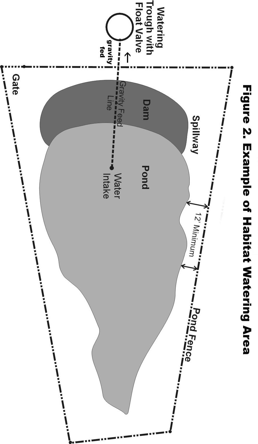
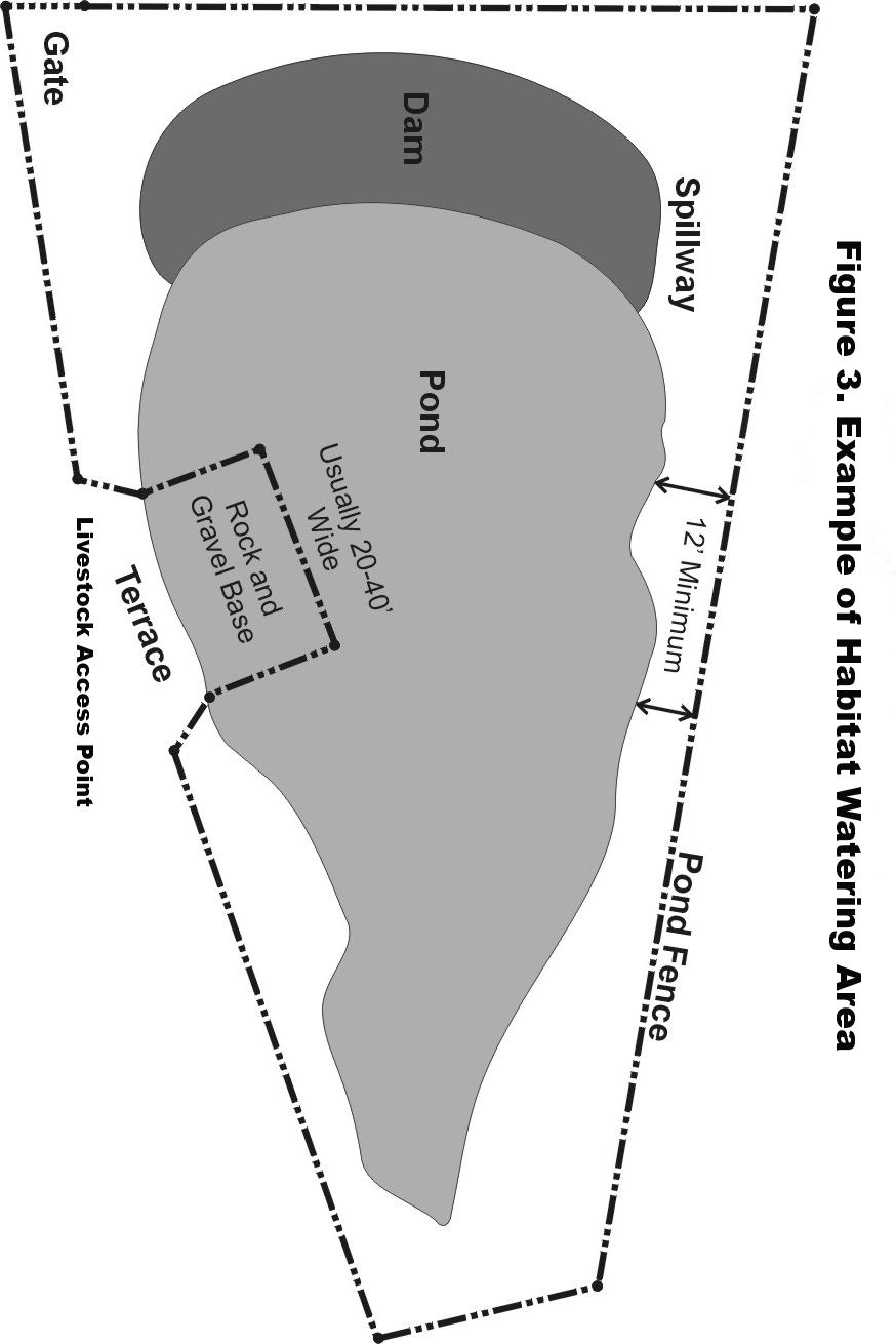
3 The desired condition for this project is to provide reliable water for existing and future grazing allotments to meet the following objectives: Protect and manage wildlife habitat by improving control of cattle movement and grazing management. Decrease dependence on pumping from streams. Increase wetland habitat for aquatic wildlife. Provide a more energy efficient means of providing water to cattle. Where feasible, provide more surface water for terrestrial, wetland and aquatic wildlife. Proposed Action The project proposes to construct up to nine (9) new ground water wells and four (4) habitat watering areas on the east side of Midewin for current and future cattle grazing needs (See Figure 1). Table 1 shows the allotments the new constructions would service, as well as the installation priority for the wells. Where possible, wells would be placed to provide water for several pastures to minimize undesirable visual aspects of the watering areas. The Midewin Prairie Plan was amended in 2008 and designate Groundwater Management Zones (GMZs) where disturbing the groundwater is prohibited. None of the proposed wells or habitat watering areas are located within or near a GMZ. The use of solar, wind power and gravity feed would be explored and used where feasible to reduce the amount of petroleum products needed to pump water. Watering areas would be covered with gravel to protect the surrounding soil and keep the cattle from congregating at watering stations. Habitat watering areas would be constructed by placing small earthen dams across small drainage ways to pond water seasonally. The pond area would be planted with native wetland vegetation and cattle access restricted. Water would flow by gravity feed to an adjacent cattle watering area (see Figure 2) or cattle would have limited access to a small gravel watering ramp (see Figure 3). Habitat watering areas would be approaching two acres in size. Public Involvement Request With this letter, we are initiating the procedures required of the Forest Service by the National Environmental Policy Act (NEPA). You have been contacted as part of the public involvement process, and your comments will help us determine any unforeseen issues that should be considered. We will review and consider comments during this public comment period. After the public comment period ends we will analyze the effects of proposed activities on the biological, cultural, and socio-economic environment, including water, air, soils, sensitive species, federally threatened and endangered species, hazardous materials, recreation, and heritage resources in order to make a final determination. 3
4 This information is being made available to the public prior to a decision on whether or not to proceed with the proposed action for a public comment period ending on February 17, In order to be considered, comments must be substantive, or specific to the actions that are proposed. Please be sure to include your name, address, organization represented, and title. Each individual or representative of a group or organization that submits comments must sign or provide for verification of identity. Please include the title of the document you are commenting on and specific facts and supporting reasons regarding your comments for me to consider. Written, facsimile, hand-delivered, oral, and electronic comments will be accepted. Written comments must be addressed to Prairie Supervisor, Midewin National Tallgrass Prairie, South State Route 53, Wilmington, IL, Hand-delivered comments will be accepted at the address above during regular office hours, from 8 AM to 4:30 PM, Monday through Friday. Oral comments may be provided at the Midewin Supervisor s Office during normal business hours via telephone (815) or in person. Electronic comments must be submitted in a format such as an message, plain text (.txt), rich text format (.rtf), and Word (.doc) to commentseastern-midewin@fs.fed.us. Copies of the Environmental Assessment will be mailed to those submitting comments and to those who request copies. If you have any questions about the proposed action or the purpose and need, please contact Jeff Tepp, Project Leader, at the address above, by at jtepp@fs.fed.us, or by phone at (815) Thank you for your interest in activities at the Midewin National Tallgrass Prairie. Sincerely, /s/ Renee C. Thakali (for) WADE A. SPANG, Acting Prairie Supervisor Midewin National Tallgrass Prairie 4


5 Chicago Road Figure 1. Proposed Cattle Watering Areas Hoff Road " H1 " H2 PA1 PW7 PW8 CW11 E1 PW2 E1 E1 CW4 Road 1 North E7 PW11 PW9 " H3 Road 1 North PW10 " H4 CW9 CW5 E10 E9 CW2 E8 CW3 PW3 CW1 E3 Central Road Victory Drive Group 1 Drive South Chicago Road E4 Central Road PW6 PA4 E6 E4 Wilmington-Peotone CW7 PA3 Midewin NTP Boundary ¹ Compiled by the Midewin NTP on 12/12/2008 using their most current GIS data available. GIS data displayed is intended for this project and using the data for other purposes may yield inaccurate or misleading results. Miles...projectCattleWateringEA\GIS\CattleWateringScoping.mxd E4 CW6 PW4 E4 PA2 CW8 Midewin National Tallgrass Prairie South State Route 53 Wilmington, IL Legend Proposed Allotments Existing Allotments Proposed Wells Cattle Wells " Habitat Watering Areas Roads
6
7
8 Figure 4: Cattle Watering Area Diagram