Tropical Agro-Ecosystem Function
|
|
|
- Alvin Montgomery
- 5 years ago
- Views:
Transcription
1 Tropical Agro-Ecosystem Function Soil erosion by water and wind Dr. Ronald F. Kühne; Georg-August-University Göttingen Department for Crop Sciences Tropical Agronomy Grisebachstr. 6, Göttingen, Germany
2 Soil erosion - Contents 1. Agents, factors, causes and types of erosion 2. Soil erosion by water 3. Erosivity vs.erodibility 4. Fundamental processes 5. Measurement 6. Control 7. USLE
3 Agents and types of soil erosion; adapted from Lal (1990) Erosion consists of: 1. soil detachment 2. transport 3. sedimentation
4 Factors of soil erosion; adapted from Lal (1990)

5 Classification of erosion forms rain splash rill erosion sheet erosion gully erosion
6 The cycle of materials: natural vs. accelerated erosion
7 Natural vs. accelerated erosion
8 On- and off-site effects of erosion damage to crops (exposure of roots, choking in sediment, scouring) removal of fine particles loss of nutrients reduced infiltration and water-holding capacity -> reduced water availability harder to cultivate accumulation of soil at depressions removal of topsoil (and subsoil in extreme cases) reduction of rooting depth reduced accessibility (gullies) deterioration and complete destruction of the land resource base lowering of groundwater level landslides and mudflows (destruction of settlements, infrastructure) water pollution and eutrophication: soil particles in water runoff carry along fertiliser residues, pesticides, dissolved minerals (such as salts) and animal wastes (with associated bacteria) silting of irrigation canals and natural water courses decreasing the capacity of water reservoirs
9 Tolerable soil loss b. Soils that have a favourable substratum and can be renewed by tillage, fertiliser, organic matter, and other management practices. a. Soils that have an unfavourable substratum, such as rock, and cannot be renewed economically.
10 Tolerable soil loss estimate is based on data from Bennet (1939)!! A-horizon formation rate: 2.5 cm in 30 years = cm per year. This rate assuming a bulk density of 1.34 equals 11.2 t/(ha year); cm/year * 1.34 g/cm³ * * cm²) / (1000 * 1000) = * 1.34 *100 = 11.2 t/ha If soil loss is 10 t/ha and the P enrichment ratio of the sediment is 3, then the P-loss is equivalent to a loss of 30 t/ha of topsoil.
11 Erosivity vs erodibility Climatic erosivity, or the ability of the climate to cause erosion, is an integrated effect of all climatic variables that contribute to the driving force that causes erosion: kinetic energy. Soils exhibit different degrees of susceptibility (soil erodibility) to the forces generated by erosion agents. Different soils respond differently to the identical kinetic energy of raindrops or the shear stress exerted by moving fluid.

12 Rain drop impact and soil splash
13 Kinetic energy of rain and run off
14 Interaction between rainfall, overland flow, and terrain on splash and sediment transport (adapted from Chisci, 1981).

15 Methods to assess soil erosion
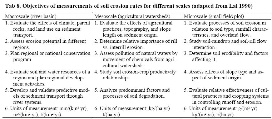
16 Scales of measurement
17 Principles of control
18 Factors affecting the efficiency of ground cover on agricultural land
19 Types of mulch materials and ways to procure them (adapted from Lal 1990)
20 Classification of conservation works according to their purpose (adapted from Hudson, 1992)
21 Types of terraces for different slopes (Hudson 1992)
22
23 Further variations of terraces
24 Improvements of trad. agricultural systems (adapted from Lal, 1990)
25 Reported rates of erosion in tropical forest and tree crop systems (Wiersum, 1984) Comparative effects of stone lines and buffer strip cropping on runoff and erosion from a soil at Allokoto, Niger (Delwaulle, 1973)
26 The Universal Soil Loss Equation Wischmeier and Smith (1978)
27 A = R*K*L*S*C*P A = average annual amount of soil loss (t ha-1 year-1) R = (MJ mm ha 1 h 1 year-1) rainfall parameter as a measure of the erosive force (erosivity) of rainfall, usually equal to the local value of the erosion index (EI). E, the kinetic energy of rainfall, multiplied by I30 (maximum intensity of rain in 30 minutes expressed in cm per hour). This index corresponds to the potential erosion risk in a given region where sheet erosion appears on a bare plot with a 9% slope. E = log10i K = soil erodibility factor (t ha h ha 1 MJ 1 mm 1) a number reflecting the susceptibility of a certain soil type to erosion. = average soil loss per unit of factor R from a standard field plot (22.2 m long, 9 % slope in clean tilled continuous fallow). Or estimated using physical / chemical soil properties such as texture, organic matter, a structural index and the profile permeability L & S = factors (no unit) adjusting the soil loss estimate for slope lengths and slope gradients other than standard C = (no unit) effects of cropping systems and management including vegetation cover. The value is <= 1 (1 = continuous fallow) P = (no unit) benefits of conservation practices such as contouring, terracing and strip cropping.
28 Equations used to determine the monthly/annual values of the erosivity according to the area of the territory and their respective authors. Eqs. number (1), (2), (4), (6), and (7) were based from the Fournier's model. Eqs. (3) and (8) are linear models and Eq. (5) is an exponential model. Rx is R factor (MJ mm ha 1 h 1 year 1) for month x, Mx is average monthly precipitation depth (mm), and P is average annual precipitation (mm) (Silva, 2001 in Silva 2004).
")
 for Brazil")
29 Comparison of the annual pluviometric (left, in mm year 1) and the annual erosivity maps (in MJ mm ha 1 h 1 year 1) for Brazil (Silva 2004)
30 Nomogram to estimate soil erodibility factor K from soil properties
31 Measured index of erodibility K in West Africa (Roose, 1977)
32 Vegetal cover factor (C factor of USLE) and cultural techniques in West Africa

33 Values of topographic factor LS of USLE for specific combinations of slope length and steepness (Wischmeier & Smith 1978)