Early Warning Systems in Eastern
|
|
|
- Liliana Washington
- 5 years ago
- Views:
Transcription


1 Early Warning Systems in Eastern and Southern Africa: by Erick Khamala Senior Remote Sensing Officer RCMRD
2
3
4 Our Products and Services Training: i Geoinformation and IT applications, Project Services: at Local, Regional and Continental levels, Advisory Services: mainly to Member States, Spatial Data: acquisition, archiving and dissemination, Early warning and forecast: Disaster early warning (flood, famine, epidemic diseases, etc.) Research and Development: both applied and fundamental research, and Engineering Services: maintenance, repair and g g, p calibration of Survey and mapping equipments


5 The Role of RCMRD in Disaster Management in Eastern and Southern Africa To Strengthen national and regional capabilities in the area of Remote Sensing and GIS to cater for early warning information for food security, natural resources and disaster management. MORE SPECIFICALLY: To promote use of space technology in early warning for food security and disaster management Capacity building in Geo-information technologies and ICT Promotion of National and Regional development of SDI Provision of advisory services in the application of Geo-information technologies for sustainable development Contracting members Non-Contracting member
6 RCMRD s sample activities in Early Warning Food Security and environmental monitoring (USGS/Fewsnet, IGAD Climate Prediction and Application Centre, DLCO, WFP, ILRI, LEWIS, GMFS) Flood modeling and prediction (USGS, SERVIR-Africa) Disease Modeling and Prediction Rift Valley Fever (WRI, AU-IBAR, UoN, USGS) - Mapping of HIV/AIDS on the Mombasa Kampala highway (Manitoba University, UoN) Land degradation mapping and monitoring - Deforestation (Mau Forest) - Land use / Land cover change (Kordofan Region, South Sudan) -AMESD(African Monitoring of the Environment for Sustainable Development) Capacity building for disaster management - Training in the use of modern Geo-information technologies in early warning and food security, disease mapping, land degradation, disaster risk management - Servir-Africa Project: a capacity building project enhancing access to data and tools - Garnet-E Project: a networking project for disaster management actors Monitoring urban sprawl (Informal settlements)-urban growth prediction Development of Multi-Hazard Atlas of the GHA Region Plans to install a MODIS Direct Receiving i Station ti at RCMRD are underway
7


8 GARNET-E is a GMES Project under the Seventh Framework Programme: EC 7FP: Theme 9\GMES SPA : International Cooperation GARNET-E E GMES for Africa: Regional Network for Information Exchange and Training in Emergencies brings the GMES Emergency Response Service to Africa
9
10


11 Some EW Activities Undertaken By RCMRD
12 Drought: has become a recurrent phenomenon affecting millions of people in Africa each year
13


14 Identification of Hotspots
15 Ground Confirmation of hotspots
16 Ground Confirmation of areas with better conditions
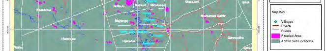
17 Flooding: Flooding is the second major disaster in the region. The predictability lead time of flooding varies from minutes (flash floods) to weeks (stream floods) The key variables that need to be indicated in the prediction of flooding are: The timing (when), The geographical area (where) and Water level, and velocity. The indicators that are monitored for flood prediction are: Precipitation, Soil moisture, River gauge level All of these indicators are monitored both from satellite and ground observations.


18 Flood forecasting using GeoSFM: case of Nzoia basin
19
20


21 Landslides Mau Forest: 1986 Mau Forest: 2000


")


22 Mau Forest, Kenya Forest - 292,192.4 Ha (2, Km 2 ) Deforested 142,879.4 Ha (1, Km 2 ) Reforested 60,411.0 Ha ( Km 2 )
23 The 2004 landslide in Olokurto Division Deforested areas Landslide risk map in Olokurto Division, Mau Forest


24 F. Epidemic diseases (predicting outbreaks of RVF in GHA)


25 Rift Valley Fever Outbreak Prediction Rift Valley Fever Risk Map (Livestock and human disease transmitted by mosquito) Uses NDVI, Precipitation and Temperature information Sensors: MODIS and AVHRR
26 International Charter: Project Manager s (RCMRD) experiences from activations in Africa Cases of Charter activation 109 and 309
27 Charter Activation 309 Charter Activation 309: Disaster call was received from Kenyan Red Cross and UNOCHA and confirmed from international news agencies USGS and UNOSAT had jointly activated the charter and appointed RCMRD as project manager RCMRD had been following the situation of flooding in the region using SERVIR-Africa flood forecasting tool It had produced regional early warning maps
28 Charter Activation Cont Charter Activation 309: Disaster type: Flooding in Eastern Kenya from 2 nd to 10 th of May 2010 It was a wide spread flooding that affected more than 300,000 people with more than 20 causalities (Daily Nation, Red Cross and UNOCHA). Flooding occurred as a result of swelling of Tana River in Kenya as a result of heavy rains in the upper part of the basin.
29 Ethiopia Somalia Kenya Moderate Severe
30 Ethiopia Somali a Moderate Severe May 11, 2010 flood potential
31 Ethiopia Somalia Moderate Severe May 15, 2010 flood potential
32 Charter Activation 309 Cont Data Acquisition: iti MERIS and MSG were looked at: But very cloudy and not usable SPOT -5 image and IKONOS received But not usable due to cloud cover - DMC data was also received - But not usable due to cloud cover - RADARSAT for May 3 rd and 6 th was found to be the appropriate image


33 SPOT Image of 6 th of May
34 Charter Activation 309 Cont


35 Disaster Map for Activation 309


36 Disaster Map for Activation 309
37 Long-Term Early Warning Systems Human induced environmental changes are increasing the frequency and the intensity of natural disasters e.g Global Warming Land degradation and desertification (deforestation, overgrazing, wetlands encroachment, etc)


38 AMESD: Land Degradation Assessment Component The Key environmental Issues are: Deforestation Uncontrolled and unplanned land use Accelerated soil erosion Extensive Land degradation (Loss of the fertile top part of soil horizon) Degraded d land Satellite image Cropped Land Degradation assessment Index Natural/Biolog. Factors = + Physical Factors + Socieconomic Factors Completely eroded land No cropping (Degraded) Geospatial Modeling


39 The case of Lake Victoria 1973 Increasing levels of siltation over the years


40 The case of disappearing lakes in Ethiopia Lakes disappeared ed within 17 years
41 Lake Baringo Catchment, Kenya... implications to agriculture


42 (Kenya s Vision 2030) LEGEND Bare Anthropogenic Disturbances Crater Forest Grassland Lake Open to Closed Shrubs Riverine Vegetation *If factors were to remain constant
43 Historical and Future Land Use / Land Cover Change Analysis LULC Class Bare Anthropogenic Disturbances Crater Forest Grassland Lake Open to Closed Shrubs Riverine Vegetation Area in Km 2
44 Understanding Future Climate Change Trends and their implications to Agriculture
45 Current Potential Pyrethrum Growing Areas Future Potential Pyrethrum Growing Area
46 Legend Currently Agriculture: Future Pyrethrum Currently Forest: Future Pyrethrum Currently Open to Closed Shrubs: Future Pyrethrum Area in Km 2 Currently Riverine Vegetation: Future Pyrethrum


47 Enhance Drought Risk Reduction in Northern Kenya and Southern Ethiopia especially for the natural resources management interventions
48 Pastoral Mobility in Isiolo District prepapred using participatory approach
49 Map of Land use / Land Cover and Water Resources


50