Mills et al (2003) determined that aggregate extraction activities in Areas
|
|
|
- Jemimah Pierce
- 5 years ago
- Views:
Transcription


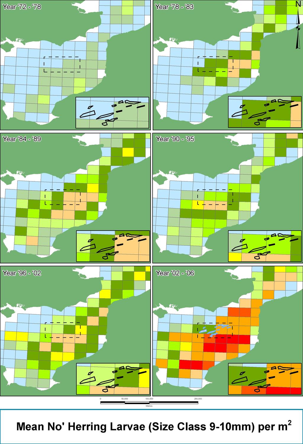
1 Part 1 Section 4: Collated Data Analysis and Results 4.1 Herring Spawning Potential Assessment Overview The ECA Regional Monitoring Blueprint v0.3 specifies a commitment to collate and assess data related to the potential for the seabed to support herring spawning activity within the ECR. Advice provided by CEFAS suggested that the ICES Herring Assessment Working Group (HAWG) should be contacted to request provision of relevant herring survey data to provide a foundation for this aspect of regional monitoring. The coordinator of the ICES HAWG has been contacted and larval survey data has been made available to the ECA to enable this aspect of the regional monitoring to be undertaken. It is proposed that data collected by the internationally coordinated annual herring larvae survey of the southern North Sea and Eastern English Channel is used to describe herring biomass levels and provide a description of the abundance of larvae in relation to adult stock size. These data will then be reviewed with other data collected during the 2005 regional baseline and licence specific surveys (seabed photograph, swath bathymetry, hi-resolution sidescan sonar, Hamon grab, 2 and 4m beam trawl data and scallop dredge surveys). It is anticipated that this combination of data will allow a determination of the potential for an area to be considered favourable for spawning activities. For the purposes of this report, the herring spawning potential survey completed by Gardline (2002) and the review undertaken by Mills et al (2003) provide the basis for the assessment of herring spawning potential for the region. Seasonal operational restrictions on extraction activity have been implemented in some areas based on these assessments. Future development in understanding of this issue will enable review and amendment of operational restrictions where appropriate. The relevant results of seabed character studies (Section 3.1) will be combined with the epibenthic and seabed photography data to provide a description if the physical nature of the seabed in the region. This will subsequently be combined with the ICES herring spawning and stock assessment data to determine the suitability of the seabed for herring spawning. The assessment will also utilise relevant licence specific physical monitoring data where available. Herring are pelagic fish that spawn on the seabed. Parts of the English Channel have been identified as being important for herring spawning & as such both seasonal dredging restrictions & regional assessment of herring spawning activity are required. Outputs of Mills et al (2003) undertaken by Cefas Images online at: Mills et al (2003) determined that aggregate extraction activities in Areas 461 and 475 would be most likely to influence herring spawning activity and as such seasonal bans on aggregate extraction activity have been imposed. 4.2 Herring Spawning Potential Methodology Following initial discussions between the ECA and CEFAS regarding the availability of herring larval data, the ICES HAWG was contacted to discuss herring data that would be of use to the ECA regional monitoring project. The ICES HAWG coordinator confirmed that annual herring larval data covering the ECR would be made available. The data cover a period from 1972 to The data were subsequently provided to the ECA for inclusion in the regional monitoring programme. Analysis Stage 1 The data was input to the ECA GIS. The data analysis techniques outlined in Mills et al (2003) were applied to the data set. A series of charts (see below) were produced showing the density of herring larvae (9-12mm length classes 5-8mm length class not included due to data deficiencies) in 1/9th ICES rectangle grid cells. Grid cells will subsequently be divided into approximately 1000 smaller cells. The mean larval density of selected size classes will then be able to be determined for the entire data set. The results of data analysis are shown below and in Figures 44 to
2 32

3 4.3 Herring Larval Data Results and Further Analysis The plots of larval density indicate that prior to 2002 maximum larval densities rarely exceeded 1000 per m 2 for both size classes. Between 2002 and 2006 larval densities exceeded 100,000 per m 2 principally due to elevated densities during the survey. Whilst larvae are evident through the ECR region, the larval distribution plots suggests that larvae are likely to have originated principally from areas to the south of the ECR in French waters. As expected, due to the effects of mortality, initial comparison of the 9-10mm and 11-12mm larval size classes show that larval densities reduce as the larvae age. Interestingly, the most significant spawning event, identified during the survey, seems to suggest that high numbers of larvae were spawned from a very wide area of the Eastern English Channel, suggesting that if sufficient spawning stock exist in the area then spawning activity will be widespread. Analysis Stage 2 Based on the approach developed by Gardline (2002), physical data (PSA, sidescan, swath bathymetry) will be reviewed in the context of the larval data described above. Through a review of these two main data sources, definition of the character of suitable spawning grounds, and their distribution within the ECR, will be able to be undertaken and agreed through discussion with CEFAS and the ECR TWG. Proposed Future Analysis The following aspects of the herring spawning potential assessment have not been completed but will be pursued in the next twelve months. 1. A determination of the dispersion rate and direction of herring larvae will be undertaken using tidal current models for the region with reference to the time take for larvae to reach 9-10 and 11-12mm size classes. 2. The likely origin of larvae will be determined based on the hydrodynamic conditions and growth rate data and this will be compared with seabed sediment data to determine areas where herring may prefer to spawn. Outputs It is proposed that there will be two main outputs from this study: 1. A section within the next annual monitoring report that provides an assessment of herring spawning potential based on the acoustic data collected during the baseline monitoring and using Gardline's methodology. 2. A section within the annual monitoring report that presents the outputs of the data provided by ICES HAWG. These data would be mapped using the EEC GIS developed by Emu at a resolution acceptable to CEFAS. Optimal interpolation techniques will be used to contour the data and to summarise within spatial units of fixed size. Combination of the information described above would enable an integrated view of the likely potential for herring spawning of areas within the ECR. The outputs, and integrated view, will be used to provide the basis of discussion between the ECA and members of the Technical Working Group to define potential herring spawning grounds in the context of aggregate extraction activities. 33

4 34 Archaeology The collation of archaeological data undertaken for the REA provides the best assessment of regional archaeological heritage. Review of this assessment will be undertaken periodically as licence specific monitoring is incorporated into the data set. A review of extraction activity in the context of known wrecks and the archaeological potential of dredging permission areas. A description of any finds from the ECR reported under the BMAPA/English Heritage Protocol (2005). The findings of licence specific geophysical surveys. At present, the data from the REA and licence specific assessments have not been collated but these will be gathered in the following 12 months and input to the ECA GIS as they become available. Further regional monitoring reports will provide the following with respect to marine archaeology: Wreck locations, status and exclusion zones. Location of significant anomalies within dredging permission areas. Archaeological potential based on palaeo-environmental conditions as defined in licence specific assessments of archaeological potential. The data from the REA and licence specific assessments will be collated and presented to provide the following: The REA data will be employed to provide the foundation onto which further assessments will be added. In addition to this regional assessment, each licencee is required to undertake licence specific assessment of the archaeological potential of dredging permission areas. As these data become available they will be used to update the regional background assessment. The best available data related to marine archaeology within the ECR are published in the REA (Posford Haskoning, 2003) and licence specific archaeological assessments. 4.4 Fishing Activity In future monitoring reports, collated data will be used to provide an annual description of fisheries activity on behalf of all members of the ECA. This analysis of fishing activity will subsequently be integrated with aggregate extraction activity data to determine where and how interaction between the two occurs. A fisheries liaison protocol (see Part 2 of this report) has also been developed that it is hoped will yield more specific activity information. In addition to the overflight data, landings data have also been requested to determine the importance of the region in terms of earnings. Fishing activity, plotted by nationality, shows that French vessels are most active in the ECR. Defra MFA have provided the most up to date overflight data and these have been incorporated into the ECA GIS. Plots by nationality and activity for are provided below. Results confirm the findings of the REA, in that French vessels are most active in the region, with Dutch, Belgian and UK vessels active to a lesser extent. The plot of activity by gear type also backs up the REA findings, showing that demersal/beam trawling and scallop dredging constitute the most common methods of fishing in the region. Initial collation of fisheries activity data uses Defra overflight data for the region. Overflight data were presented in the REA (Posford Haskoning, 2003) and this initial data set will be supplemented with data from 2003 to present and annually thereafter. 4.5
 Data cropped within 12 nautical miles. Demersal and dredge fishing is undertaken over a wide area.")
5 35 Fishing in the ECR, in terms of the gear types employed, is undertaken principally by trawling and scallop dredging. The most common nationality of vessel recorded in the region is French. Fishing activity in the Eastern English Channel by gear type (Source: Defra MFA overflight data) Data cropped within 12 nautical miles. Demersal and dredge fishing is undertaken over a wide area. More intensive activity is evident to the north east, north and north west of the region.


6 4.6 Aggregate Extraction Activity The location of dredging vessels is monitored constantly when engaged in extraction activities by an onboard electronic monitoring system (EMS). The position of the vessel is recorded very 30 seconds through satellite fixes. Activities are recorded in three main ways by monitoring pump activity and dredge gear vibration sensors: No activity pumps inactive, no vibration sensor response. Pumps Running pumps active, no vibration sensor response. Dredging pumps active, vibration sensor response. The records of activity monitoring are forwarded by operating companies on a monthly basis to the Crown Estate, and their agents, Haskoning UK. These records are then collated and reported by BMAPA and the Crown Estate under the Area Involved initiative (see image below visit for more details). Dredging activity charts are produced in this way and it is now common practice to consider the findings of environmental monitoring with reference to the area and intensity of aggregate dredging that has occurred. The regional monitoring programme will commence collation of dredging activity data in 2007 by requesting the results of 2006 activity monitoring. A long term programme of dredging activity data collation and reporting will be developed in Activity reports can be downloaded from The location and activity of dredging vessels is carefully monitored. Satellite navigation systems fix the position of the vessel whilst sensors detect dredging activity. EMS plots of dredging activity are provided by BMAPA and the Crown Estate. Monitoring in the ECR will employ this method to place the results of monitoring in the context of dredging intensity. (Images from 36
7 Report Part 1 Section 4: Summary The herring spawning potential assessment has been progressed to the point that herring larval data have been acquired and input to the ECA GIS. Further analysis will be based on integration of larval data and seabed physical character data to highlight areas that have high potential for herring spawning. The archaeological assessment data presented in the REA are currently considered to offer the best available description of the marine heritage of the region. Further update and reporting of this aspect of the regional monitoring will be undertaken as licence specific data become available. Fishing activity data, from overflight, landings and fishing liaison activities, will be used to determine the nature of interactions between aggregate extraction and fishing operations. Notes: 37
8 Notes: 38