State and Local Governments
|
|
|
- Ira Wilkins
- 5 years ago
- Views:
Transcription


1 Public Engagement Maps and Apps for State and Local Governments ALLISON MUISE SCOTT OPPMANN
2 Agenda Introduction Public Engagement Maps and Apps What s Next Your Feedback
3 ArcGIS as a Platform Simple, Open, and Configurable Knowledge Workers Executive Access Public Engagement Work Anywhere Enterprise Integration ArcGIS Making Mapping and GIS Available Across Your Organization Professional GIS Transforming the Role of GIS

4 Turning Point ArcGIS Online Solutions
5 ArcGIS for State and Local Government Solutions for Esri s government customers Collection of useful maps and apps Configurable and extensible Freely available and fully supported Editing Workflows Focused Maps and Apps Analytical Models Community of users Best Practices / Implementation Support Network of Esri Services and Partner offerings Help users implement, sustain and enhance Information Model..Available on-premise or in the cloud
6 Our Mission Deliver maps and applications quickly throughout their organization Roadmap for standard capabilities, improve service delivery, expand reach, innovation. Stay current with future releases / avoid legacy technology Save time and money, leverage new ArcGIS offerings, focus on complex or unique problems. Unlock geospatial platform so it can be leveraged by many Leverage the collective knowledge of the entire community Best practices, industry tradecraft.


7 Public Engagement Maps and Apps State and Local Governments Promoting Transparency Access Public Info Open Data Locate Places Tell Stories Public Information Gather Sentiment Solicit Feedback Have Dialog Enlist Participation Take Action Citizen Sensor Collaborate Expand Community ArcGIS Hub Increasing Accountability Participatory Budgeting Park Locator Public Notification Vision Zero Wildlife Management Area Locator School Locator Citizen Problem Reporter My Tax Distribution My Government Services Site Selector Permit Status Road Closures Demolition Tracker Election Polling Places Tax Parcel Viewer My Elected Representative Transportation 511 Adopta Homeless Service Locator
8 Public Engagement Maps and Apps Sharing Public Information Most popular form of public engagement for government agencies Static maps or interactive apps Typical patterns: Show me maps and apps Find a location and give me driving directions Tell a story Examples: Park Locator, Land Use Maps, Tax Parcel Viewer, Snow Routes, My Health Services, Capital Improvement Plan, Election Polling Places, etc. Are complemented more recently by Open Data
9 Public Engagement Maps and Apps SHOW ME!
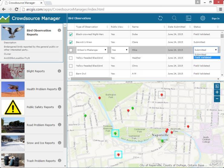
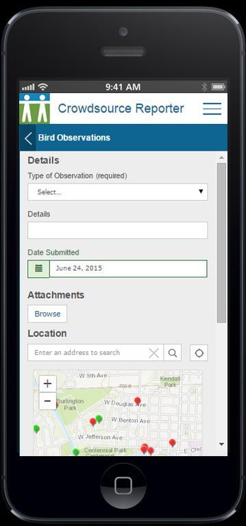
10 Public Engagement Maps and Apps Engaging General Public as a Sensor Emerging form of public engagement for government agencies Typical patterns: Report a problem or observation Gauge sentiment Survey community Engage public in maintenance operations Examples: 311 / Problem Reporting, Wildlife Photo Survey, Adopt a Catch Basin, Land Use Public Comment, Vision Zero, etc. Responsive web apps or native mobile apps
11 Public Engagement Maps and Apps SHOW ME!
12 Public Engagement Maps and Apps Solutions.arcgis.com Share public information: Election Results Transportation 511 Public Road Closures Map Find things near me: Park Locator / Wildlife Locator School Locator My Government Services Tell stories: Opioid Awareness Story Map Capital Improvement Plan Provide data access Open Data Public as sensors: Drug Activity Reporter Vision Zero Citizen Problem Reporter Public Comment Photo Survey Adopta
13 Public Engagement Maps and Apps Taking Action Complement Citizen as a Sensor applications Drive accountability and response actions Typical patterns: Monitor problems or observations Assign responsibility and communicate status Monitor progress Examples: Citizen Problem Manager, Mosquito Service Request Manager, Vision Zero Dashboard Can be extended to support more comprehensive workflows Generate report IDs, moderate content, send notifications, CMMS integration
14
15
16
17
18
19
20 Public Engagement Maps and Apps SHOW ME!


21


22 Public Engagement Maps and Apps Creating Destinations Intuitive ways to share apps and data, measure progress and demonstrate accountability
23 How do I get started? Leverage solution offerings to maximize technical expertise and minimize deployment time Deploy quick wins Configure your mapping platform Plan Align with strategic business needs Organize your open data Implement one or more focused maps and apps Test / Feedback Deploy Iterate. Configure Next? Envision Iteration 1 Iteration 2 Iteration 3 Next? Next? embrace an agile implementation approach

24 It s a Process CONTINUOUSLY EVOLVING SOLUTION
25 What s New Crowdsource application enhancements Theming and branding, comments, geographic report restrictions, etc. New ArcGIS for State and Local Government solutions Participatory Budgeting, Adopta, Homeless Activity Reporter, Drug Activity Reporter, Environmental Impact Public Comment, etc. Crowdsource scripts that extend workflows Generate report IDs, moderate content, notifications Simplified deployment approach ArcGIS Solutions Deployment Tool
26 Coming Soon Continuously Evolving Solution Offering Crowdsource application enhancements Accessibility, etc. New ArcGIS for State and Local Government solutions Public Crime Maps, Warming & Cooling Centers, Permit Status, Public Notification 2.0, ROW Permitting ArcGIS Hub initiatives Homelessness, Opioid Epidemic, Vector-Borne Diseases Crowdsource scripts that extend workflows Geographic assignment, Workforce for ArcGIS and CMMS integration


27 Join the Community It s not just about the technology
28 Closing Deliver a state and local government GIS that enables success Easier to deploy and sustain Evolve and grow the collection of apps Develop a community of users Provide a platform for partners to deploy their solutions


29 UC Events ArcGIS for State and Local Government Sessions Fourteen tech workshops Seventeen demo theatre sessions Special Interest Group Wednesday lunch for LG State and Local Government Social Solution Island Focused conversations / support Search for: ArcGIS for Local Government or ArcGIS for State Government


30 Please Take Our Survey on the Esri Events App! Download the Esri Events app and find your event Select the session you attended Scroll down to find the survey Complete Answers and Select Submit
31 Thank you Be innovative, aware, and know you are not alone


32