Integrating Analytic Talent for Intelligence Analysis. David Attaway John Fry
|
|
|
- Nelson Parrish
- 5 years ago
- Views:
Transcription

1 Integrating Analytic Talent for Intelligence Analysis David Attaway John Fry

2


3

4

5

6 Location, Mapping and GIS Are Becoming Essential A Fundamental Language for Understanding and Managing Our World Providing Content and Context About Everything

7 GIS Provides the Framework and Process For Enabling a Smarter World Data Integration and Management Visualization and Mapping Analysis and Modeling Action Decision- Making Planning and Design Transforming How We Think and Act Creating a More Sustainable Future

8 GIS Connects Everyone Creating a System of Engagement Supporting Real-Time Awareness and Collaboration Communities Organizations People GIS Provides a Common Language for Communication

9 GIS Embeds Advanced Analytics and Visualization Providing a System of Insight Interactive Exploration Big Data GeoAnalytics Spatial Analysis & Geoprocessing
10 What does this mean?
11 GIS is a Multi-Int Platform Terrain Workstation Imagery Workstation All Source Workstation CI / SIGINT Mobile Enterprise Integration Portal Analysis Services Internal Data Sources External Data Sources Classified Open-Source
12 GIS Integrates Intelligence and Operations Geospatial Analysts Imagery Analysts HUMINT Analysts SIGINT Analysts All Source Analysts Enterprise Integration Commanders and Executives Mobile Operators Portal Analysis Services Internal Data Sources External Data Sources Classified Open-Source
13 Intelligence Platform ArcGIS Can Provide the Intelligence Platform Multi- National National Theater Division Battalion Platform GEOINT IMINT SIGINT HUMINT All Source Multi-Int Products Combined Obstacle Overlays Battle Damage Assessment Helicopter Landing Zones Target Development Enemy Capabilities Network Analysis Mobility Analysis Enemy Intention Link Analysis Route Study Image Maps Threat Maps Collection Plans Enemy Strength Incident Analysis IED Density/Threat Line of Sight Analysis GMTI Analyses/Reports Point of Origin Detection Indications and Warnings Tribal/Human Terrain Maps From Raw Data to Finished Intelligence


14 Multi-Intelligence Platform David Attaway
15 Intelligence Support to Operations
16 Decision Advantage Gained When, where and how likely is it to happen? Anticipatory Analytics What might happen? Forecasting Statistical Analysis Why did it happen? Query/Drill Down What are the specific causes? Visualization Where? How Many? How Often? Tailored Reports Where? How Many? How Often? Standard Reports What Happened? Alerts Something Happened Analytic Effort Required
17 Planning The Intelligence Cycle Dissemination Collection Production Processing Exploitation & Analysis


18 Apps For Every Phase of the Cycle Planning & Collection Exploitation & Analysis Geoform Collector Insights Pro Production & Dissemination GeoEvent Workforce Geo Planner Operations Dashboard Open Data Story Maps Crowd Source Survey123 Maps for Office Quick Report Summary Viewer Geo- Analytics Swipe & Spyglass Time Aware Focused, Powerful and Ready-to-Use
19 Geospatially Enabled Intelligence Reporting Geospatially Enabled Intelligence Collection


20 Textual Report to a GIS Manual Text Extraction Hand-jamming Automatic Text Extraction


21 Text to GIS (ClearTerra Locate XT) John Fry
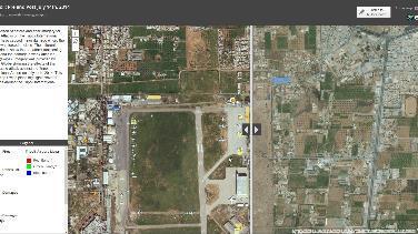
22 Field Collection Collector for ArcGIS Operations Dashboard John Fry

23 Field Collection Collector for ArcGIS Operations Dashboard John Fry


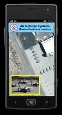
24 Critical Architecture A Complex Problem Source Data Ingest Normalize Analytics Multi-int
25 Analyst Example: GEOINT

26 GEOINT Analyst Foundation Data David Attaway
27 GIS is a Multi-Int Platform Terrain Workstation Imagery Workstation All Source Workstation CI / SIGINT Mobile Enterprise Integration Portal Analysis Services Internal Data Sources External Data Sources Classified Open-Source


28 Intelligence Preparation of the Battlespace 1 1 Define the Battlefield / BattleSpace 2 Describe the Operational Environment 3 Evaluate the Threat / Adversary 4 Platform for IPB 2 4 Determine Course of Action 3


29 Foundation GEOINT Topography Aeronautical Maritime Human Geography Boundaries Geographic Names Imagery Elevation Timely and Accurate Ready-to-Use Authoritative Delivered at the point of warfighter and analyst needs to ensure timely decision making and operational success


30 Imagery Enables the Geospatial Intelligence Domain See the Earth Find What s There Share with Others See, Find, Share

31 IMINT App David Attaway


32 ArcGIS Is a GEOINT Platform Capable of supporting TPED Share Find Professional Imagery & Geospatial Analysts See Server

33 Analyst Example: All-Source Production
34 Intelligence Analysis Workflow Intel Analyst Workflow Collection Visualization Analysis Product Creation Sharing Data Importing Workflows IDP Verifying Sensors Layering Map Templates PowerPoint Sharing Locations Filtering Models Legends Understanding Events Information Symbolizing Tools Python Scripts Screen Captures Layout View Collaborating

35 The Power of a Multi-Int Platform Putting it all together Operators Workflows & Models Tradecraft: Change Detection Land Cover Analysis Feature Extraction ArcGIS Content Web Apps Templates Widgets Dynamic Content MarketPlace Esri Provided Build-your-own Imagery Services

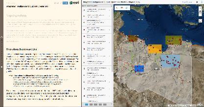
36 OSINT Analysis David Attaway


37 Intelligence Fusion Integrating all-source intelligence on a common platform using geography GeoSpatial Intelligence GEOINT Signals Intelligence SIGINT Measurement and Signatures MASINT Imagery Intelligence IMINT
38 Smarter Decisions Integrating Real-time Information Feeds & Analysis Monitor the situation through real-time tracking, routing & communications Incorporate realtime data from many sensors Maintain & share the Common Operational Picture Manage deployed Forces Portal Manage the data Collect Analyse Share Act Gather, Fuse, Analyze & Share Intelligence Formulate & Disseminate Plans

39 Connect to, Store and Analyze feeds Web Device Desktop real-time & big data capabilities Ingest high velocity real-time data into ArcGIS Perform continuous analytics on events as they are received live features live & historic aggregates & features Store observations in a spatiotemporal big data store Run analytics on stored observations stream service visualization map & feature service Visualize high velocity & volume data: - as an aggregation - as discrete features ingestion analytics ArcGIS Enterprise analytics Notify those who need to know about patterns of interest GeoEvent Server spatiotemporal big data store storage GeoAnalytics Server

 to apply them to - and what output(s) to send")
40 Analytics on the Fly apply continuous analytics by defining a GeoEvent Service A GeoEvent Service defines the flow of GeoEvents - The Filtering and Processing steps to perform - what input(s) to apply them to - and what output(s) to send the results to

41 Ship Position Historic Big Data Analysis John Fry
42 SIGINT Analysis John Fry

43


44 Sharing and Collaboration Share Building Apps to support operations with actionable intelligence Highly Visual Simple Accessible Amped Apps


45 Communicating the Analysis David Attaway


46 Tasking and Workflow Management A Platform for the GEOINT Community 60,000 Users across the U.S. Intelligence Community Apps Cloud Visualization Services IC GIS Portal Analytic Services IC ITE Foundation GEOINT Imagery Analytic Content User Contributed Content Production and Management One of our really great approaches is the use of ArcGIS as a geospatial framework the IC GIS Portal is a platform for analytics, collaboration, and data sharing that is used throughout the Intelligence Community. -Sue Gordon, Deputy Director, NGA


47 Integrating and Enriching Intelligence using Location

48 Intelligence Support to Operations


49 Please Take Our Survey on the Esri Events App! Download the Esri Events app and find your event Select the session you attended Scroll down to find the survey Complete Answers and Select Submit


50