Strata Monitoring Data Management and Application
|
|
|
- Marianna Wright
- 5 years ago
- Views:
Transcription
1 Strata Monitoring Data Management and Application
2 Presentation Outline 1. Overview Strata Monitoring 2. Data Management Processes and Current Challenges 3. Possible Solutions 4. Application of SMA
3 Strata Monitoring Systems in UG Coal Types Visual (e.g. Inspections) Mechanical (e.g. extensometry, convergence) Electrical (e.g strain gauge, extensometry) Optical (e.g. photogrammetry, laser scanning) Sound (e.g. micro-seismic goaf monitoring) Hydraulic & Pneumatic (e.g. load cells, PRS leg pressure gauges)


4 Requirement for Strata Monitoring Safety Geotechnical Design Legislative Strata is not controlled until confirmed by your monitoring system A good monitoring system is imperative to account for any residual uncertainty in geotechnical design Knowing how rock behaves and how support systems perform is critical for the design process and the design feedback loop. s324 Monitoring strata support An underground mine s safety and health management system must provide for (a) monitoring the effectiveness and integrity of strata support in each place used by a person for normal work or travel (b) Maintaining the integrity of the strata support, including, for example, by replacing defective supports.
5 Strata Monitoring Data Management Strata Extensometry Acquisition Processing Interpretation & Analysis Tell-tales, Gel/ Sonic Extensometers, convergence monitors Spot / Real-time monitoring Data entry Calculation of Displacement, Displacement rate, anchor differential, longwall surge Graphing, CAD visualisation Data analytics (H f, spatial variation in roof deformation, validation of geotechnical models etc) Administration Reporting System optimisation
6 Common Limitations and Potential Solutions

7 Common Limitations and Potential Solutions Strata Extensometry Acquisition Common Limitations Installation location in roadway Uncertainty over anchor positions Doubt over datum/ initial reading Difficulties/ inconsistencies in reading/ recording instruments Maintaining high monitoring frequencies is labour intensive Potential Solutions Frequent training for CMWs in installation and recording of monitoring devices Remote reading capability in use for high/ inaccessible excavations Continuous (Real-time) monitoring
8 Common Limitations and Potential Solutions Strata Extensometry Processing Common Limitations Data entry: Geotechsdon t have the time Data entry interfaces lacking efficiency Inconsistency in instrument naming convention Inconsistency in data entry personnel Poor database structure Calculations: Nuances in instrument output force processing in separation Still performed in MS excel in some cases Potential Solutions Integrated monitoring database More efficient data entry capability built into existing databases Outsource data entry?
9 Common Limitations and Potential Solutions Strata Extensometry Interpretation & Analysis Common Limitations Insufficient graphing capability Lack of standardised analytical tools for input into design CAD integration Correlation with installed ground support data Site geotechsgenerally too time poor to manually manipulate data in MS excel Potential Solutions Database software with capacity to: Output variety of graphing options & formats Correlate monitoring data with other geotechnical information (installed ground support, UCS, DOC, Rock mass classification data)
10 Common Limitations and Potential Solutions Strata Extensometry Administration Common Limitations Lack of reporting capability/ versatility in reporting Data collation and structure in database Database insecure on public network drive Varying reading frequencies based on proximity to face Establishing and administering TARP triggers & responses Potential Solutions Versatile reporting capabilities built into existing software Client/ server database setup
11 Current Tools in Use Strata Extensometry Customised MS Excel Site specific customisation to suit demands of monitoring system Low cost but lacking higher-end features & functionality RMM Developed and released in late noughties Efficient data entry feature, no longer supported Extochart Developed since 1999 in conjunction with Centennial Coal Accounts for many of the limitations mentioned earlier SMA New kid on the block Relatively undeveloped compared to Extochart also accounts for many of the limitations mentioned earlier


12 Strata Monitoring Application -SMA
13

14 FEATURES

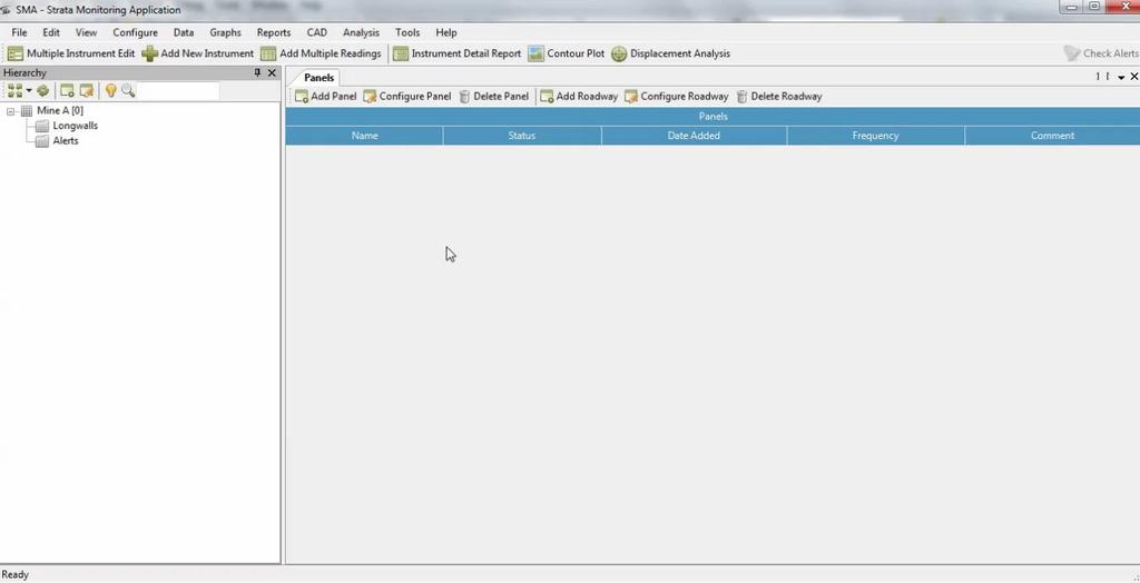
15 Database structure

16 Instrument Location vs Displacement
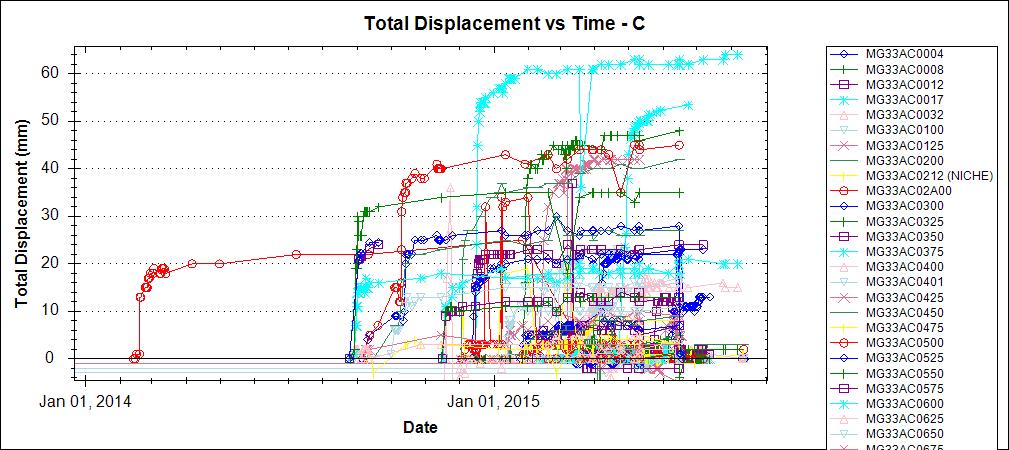
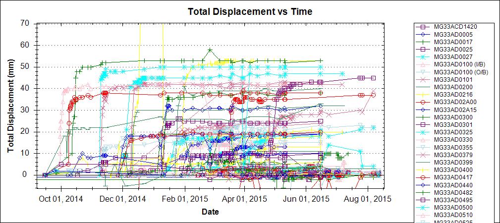
17 Displacement Analysis
18 Displacement Histogram
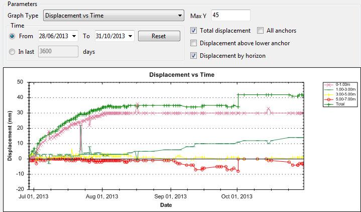
19 Displacement by Horizon
20 Longwall Surge
21 SMA FUTURE DEVELOPMENT CAD Module Group instrument coordinate selection from mine plan Analytical tools to correlate monitoring data with other geotechnical parameters Ground Support Register Database for installed ground support Integration with CAD for exporting Analytical tools for correlating strata reinforcement with monitoring results

22 SMA FUTURE DEVELOPMENT SMA-RT Interface for real time monitoring system Tablet Application Tablet Application for underground data acquisition to interface with SMA

23 SMA SNAPSHOT 22 MONTH PROJECT, 9 MONTHS TO BUILD IN CURRENT FORM 1 VERSION OF SMA UNIVERSALLY TO ASSIST STANDARDISATION ACROSS INDUSTRY
24
25