Connecting Space and Time
|
|
|
- Rhoda Holmes
- 5 years ago
- Views:
Transcription


1 Connecting Space and Time Presented by Francisco Urbina

2

3

4 From Backroom to a Explosion of Uses, Users and Data Sources


5 GIS Is Being Transformed Into a Location Platform Design Plan Prepare Decide Evaluate Act Predict Analyze Manage Measure Making it Pervasive... Involving Everyone


6 big data collections sensor networks business systems spreadsheets web services social media analytics images / video Information from many source integrated, placed on a map, and analysed based on location


7 Estimote Stickers

8


9 Consumerisation driving Expectations

10 Source: Ventana Research Location Analytics Benchmark Research 2013

11 More than Location

12 Value of Understanding Place Tobler s 1 st Law of Geography


13


14 ArcGIS Strategy Build, Sell, and Support Common Platform For Three Communities Geo-Centric Geo-Enabled Geo-Embedded ArcGIS Platform... and Provide Partners with Technology, Services, and Support
15 Esri is Geo-Enabling the Enterprise Business Systems GIS Data Architecture App Architecture Location Platform Infrastructure Architecture Enrich and improve workflows to increase organisational efficiency More than dots on a Map Reduce the cost of Spatial Transactions


16 Web GIS Supports Everyone Providing a Common Enterprise Platform Knowledge Workers Executive Access Public Engagement Work Anywhere Enterprise Integration Professional GIS Across Organisations and Across Partners... a Framework for Integration

17 Wisdom of Crowds Location Intelligence Market Study Dresner Advisory Services

18 Wisdom of Crowds Location Intelligence Market Study Dresner Advisory Services


19


20 Web GIS Helps Integrate Our Partner Solutions Breaking Down the Barriers Creating New Relationships... Supporting Collaborative Approaches


21 Without Integration

22 The Past - Sinking Feeling

23 Our Communities Struggle with Important Questions 1. Which spatial system has my data and which version? 2. How do I sync data between business and spatial systems? 3. How do I access my business data from my spatial client tools? 4. How do I merge business and spatial data with my operations systems? 5. How do I connect and sync spatial data to mobile devices? 6. How to I provide web?

24 Complexity

25 Over Engineered

26 Usability

27 Lack of Agility
28 Complementary Non-disruptive Frictionless Transparent


29


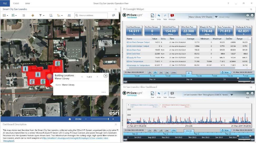
30 After Integration


31 Partners Delivering Thousands of Solutions, Apps, Services, Data and Technology
32 Connecting Space and Time OSIsoft & Esri
33 Use an Agile Methodology Iteratively and Incrementally Add New Capabilities using COTS Plan Test / Feedback Design Keep iterations brief (~30 days) Involve stakeholders Stop restart at any time Configurations accelerate delivery Configure / Code Next? Envision Iteration 1 Iteration 2 Iteration 3 Next? Done Each iteration results in deliverables you can use


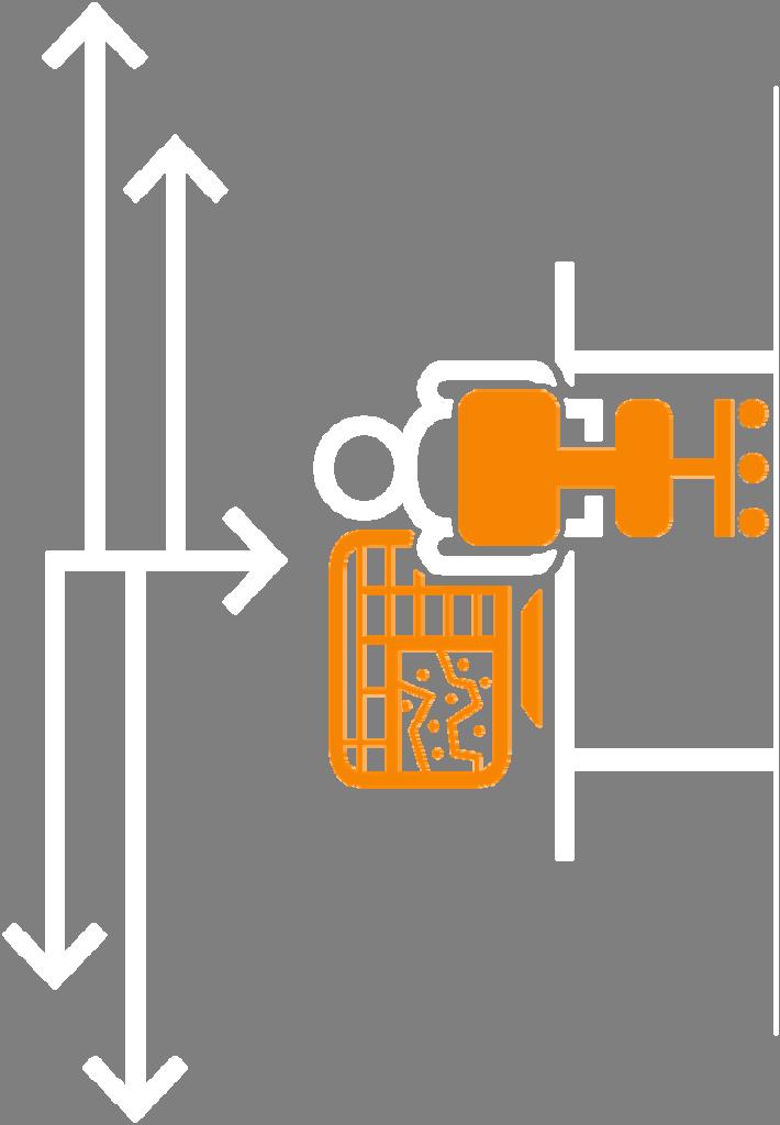
34 ArcGIS Real Time ArcGIS GeoEvent Extension for Server Integrates and Exploits Real Time Data Enabling Big Data Stream Processing Geo-Fencing Rules / Actions GeoEvent Processor Streams ArcGIS Server JMS Messages Continuous Processing and Analysis


35 GeoEvent Ext Streams ArcGIS Server JMS Messages


36 Demonstration OSIsoft & Esri

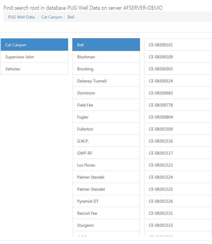
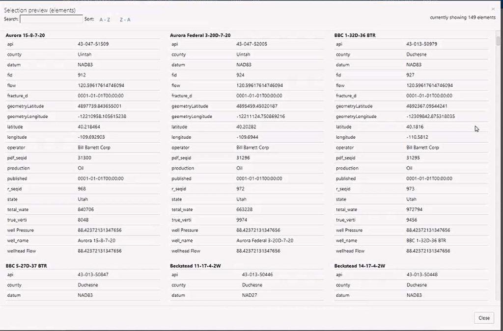
37 Operational Performance View

38 Energy Management

39 Environmental Monitoring
40 Smart Building


41 Your Dashboards & Apps Operations Dashboard for ArcGIS ArcGIS Online / Portal for ArcGIS ArcGIS GeoEvent Ext GeoEvent Services operation view web map feature layers Inputs Outputs PI Integrator for Esri ArcGIS feature layers ArcGIS Server

42 Portal Configuration Experience Not a programming project!

43 Publish your layer

44 Preview the Elements
45 OSIsoft does the work for you with each layer Automatic Configuration ArcGIS GeoEvent Extension Input Connector ArcGIS GeoEvent Extension Output Connector ArcGIS GeoEvent Extension Workflow Create PI Coresight Endpoint
 SSL / TLS Web Sock Transport Workflow (pipe\) Feature")
46 Stream Service Configuration Results GeoEvent Ext GeoEvent Services Inputs Outputs PI Geo Services Monitor (GeoEvent Service) SSL / TLS Web Sock Transport Workflow (pipe\) Feature Layer

47 Coresight End Point Created

48 Configure Pop Up to Launch PI Coresight

49 Pop Up with PI Coresight Hyperlink
50 PI Integrator for Esri ArcGIS Automatic Configuration of GeoEvent Processor Send PI Current Values to ArcGIS Platform Analyze historical data with PI Coresight Ad Hoc Trends Processbook Displays via PB Viewer Jump Start PI AF with Map Extractor
51 Cloud Architecture PI Integrator for Esri ArcGIS ArcGIS Online / Portal for ArcGIS operation view web map GeoEvent Processor GeoEvent Services Inputs Outputs PI System ArcGIS Server

52 On Prem Architecture ArcGIS Online / Portal for ArcGIS operation view web map GeoEvent Processor PI System PI Integrator for Esri ArcGIS Inputs GeoEvent Services ArcGIS Server Outputs
53 Esri Map Extractor Concepts Map Features can represent a PI AF Element Feature Layers can be represented as PI AF Template The Map Extractor builds AF templates and elements from features on a map


54 OSIsoft and Esri Supports Everyone Providing a Common Enterprise Platform Knowledge Workers Executive Access Public Engagement Work Anywhere Enterprise Integration GeoEvent Ext GeoEvent Processor Services PI Integrator for Esri ArcGIS Inputs Outputs Professional GIS


55 OSIsoft and Esri Supports Microsoft Providing a Common Enterprise Platform Esri Maps for Office Esri Maps for SharePoint Esri Maps for Dynamics CRM GeoEvent Processor GeoEvent Services PI Integrator for Esri ArcGIS Inputs Outputs Professional GIS

56 Top 7 1. Configurable Integration 2. Deliver Real Time data across the organisation on any device, any app, any time 3. Designed for non technical users 4. Increase Speed of Deployment 5. Greater Agility to meet changing business need 6. Better Business Decisions 7. Reduced Costs and Higher Value

57 THANK YOU Brought to you by 57