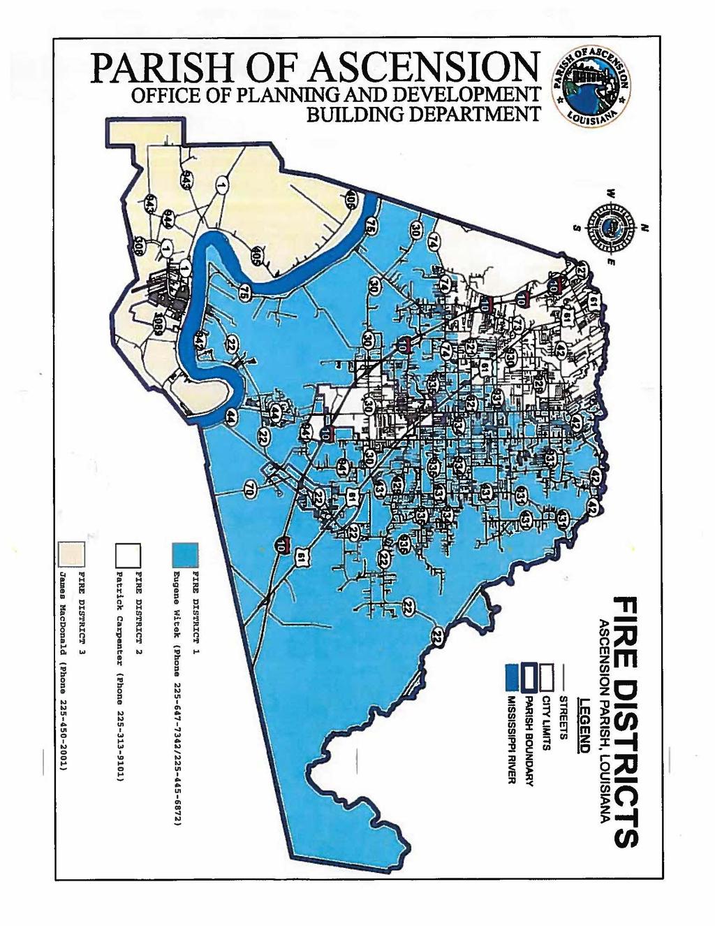
PARISH OF ASCENSION OFFICE OF PLANNING AND DEVELOPMENT BUILDING DEPARTMENT
|
|
|
- Barrie Ramsey
- 5 years ago
- Views:
Transcription
1 REQUIREMENTS FOR COMMERCIAL PERMITS 1. Submit a digital Drainage Impact Study per the current Drainage Impact Study Policy as referenced in the Ascension Parish Drainage Ordinance to Jamaica Banker JBanker@apgov.us Department of Planning & Development (225) Note: A Final Inspection of the Drainage Impact Study shall be approved prior to a Certificate of Occupancy being issued. 2. A driveway permit from the Department of Transportation and Development is needed ONLY if your business will front a state highway. See page 3 for required information. 3. Contact the Department of Transportation and Development in reference to the Traffic Impact Policy for New Access Requests Affecting Traffic on State Highway. See pages 8-10 for required information. 4. Contact the Fire District in the District that your business will be located for Fire Hydrant information. See attached map page 6 for location of your project and with a contact person to call. Note: A Final Inspection of the fire hydrant(s) shall be approved prior to a Certificate of Occupancy being issued. 5. Plans must be prepared to meet the Louisiana State Uniform Construction Code: 2015 IBC 2015 IMC 2014 NEC 2015 IPC 6. Building Plans must be submitted to the State Fire Marshall for their approval. 7. Approval is needed from the Department of Health & Hospital, Sanitation Division for the sewer system. Fire Marshall Office 8181 Independence Blvd. Baton Rouge, Louisiana (225) The Fire Marshall Approved Plans must be submitted to the Building Department for Review. 8. State of Louisiana Department of Environmental Quality Request for Preliminary Determination of LPDES (Louisiana Pollution Discharge Elimination System). 9. Submit a copy of the NOI (required if development disturbs more than 5 acres or is part of a larger common plan that cumulatively disturbs at least 5 acres), which was submitted to LDEQ to APG. 10. A SWPP plan shall be developed if the project disturbs more than 1 acre or is part of a larger plan of development that cumulatively disturbs more than 1 acre. A copy of this SWPP Plan shall be submitted to APG before the beginning of construction. 11. The Ascension Parish Traffic Scoping Information Form Filled out and submitted in accordance with the Traffic Impact Analysis Policy. 1
2 12. After ALL of the above requirements are met then you may submit your set of plans that have been stamped approve by the State Fire Marshall with letter of review to the Department of Planning & Development for their approval. NO set of plans will be accepted until all of the above requirements are met. $ Plan Review Fee. *NO CONSTRUCTION CAN BEGIN UNTIL ALL OF THE ABOVE HAVE BEEN MET AND APPROVED FOR PERMITTING. A COPY OF THE STAMPED SET OF PLANS AND THE SWPP PLAN MUST BE ON THE JOB SITE AT ALL TIMES. REQUIRED INFORMATION FOR DRAINAGE 2
3 Below is the minimum amount of information that we need in order to conduct our review: 1) Existing drainage area map with runoff rates 2) Existing topographic survey 3) Grading plan with: a) Proposed elevations for the site including all proposed grading and ditches. There should more than enough proposed elevations to clearly depict the highs the lows, and intermediate elevations. b) All existing and any proposed servitudes. c) Proposed runoff rates leaving the site COMMERCIAL DRIVEWAY CHECKLIST 3
4 The plans must include the following information: 1) Width of proposed driveway a. Minimum width is 24 foot and Maximum width is 35 foot b. One Way driveways are to be 16feet wide c. Driveways are to be 90 degrees to the road way d. Driveways are to slope down away from the roadway. 2) Size of each radius on all proposed driveways a. Minimum 30 foot radii outside and 10 foot inside minimum (unless specifically approved) Standard LADOTD One Way (R6-2) signs must be used. 4 signs per driveway 3) Information on drainage pipe to be used (type, size and length) a. Reinforced Concrete Pipe is required. b. Minimum pipe size is 18 diameter c. Pipe length should be calculated for a 4:1 slope to invert of pipe at pipe ends. d. No head walls over pipe ends. 4) Curb removal. Curb is to be replaced with driveway curb (unless specially approved). 5) Distance from proposed driveway to a State Highway. 6) Distance from property line to the proposed driveway. 7) Existing driveway with the distance between the existing driveway radii and proposed driveway radii. 8) Radii must start 5 foot off property line. If not, then a letter of No Objection must be signed by neighboring property owners and submitted with application. 9) Radii are to be a minimum of 10 feet off another driveway/road radii and/or 25 feet off property line adjoining existing roads. 10) Shoulder, all travel lanes, turn lanes and any roads/driveway s in the vicinity with all dimensions. 11) Striping Details with all dimension. 12) The North Arrow, P/L (property line) and R/W (State right of way) must be on sketch. 13) Either U.S. or LA is used to distinguish State Road and Parish Road. 14) Final grade for site and driveways 4
5 15) Topography and proposed site drainage plans to be included on separate sheets. Plans should show runoff before and after development. Plans should also include a profile view of each driveway. Permit Application is to be signed in ink by the property owner or his designated agent. All information on the application is to be legible. Four (4) copies of plans showing how and where the driveway will be located within the property. ( Plans cannot be larger than 24 x 36 ) After the permit and sketch is received the District Permit Specialist will visit the site to determine pipe size and verify all information. Driveway must be MARKED to insure correct location. No deposit required. When the driveway is completed (as permitted), notify the District Permit Specialist so driveway can be inspected and released. Approval of the permit takes approximately 3 to 6 weeks if the application is filled out correctly and plans have all information required. Unusual circumstances may require longer. The permit application must be approved before the work can be started and the owner s copy of the approved permit is to be available at the site. If you have any questions, call Mr. Mike Procell, District Permit Specialist, at (225) Office hours are from 7:00 a.m. to 3:30 p.m. Mail Application to: Louisiana Department of Transportation and Development District 61 Permit Office P.O Box 831 Baton Rouge, LA MINIMUM HYDRAULIC REQUIREMENTS FOR COMMERCIAL AND SUBDIVISION DRIVEWAY PERMITS 5
6 I. Site Location and Description Vicinity Maps Identify adjacent developments Identify major drainage outfalls Identify street and highways Describe predominate existing and future land use within project watershed Describe the proposed development Provide estimate of both pre and post development impervious area II. Watershed Map and Information Source is latest USGS 7.5 Minute Quadrangle Map or Better Delineate drainage boundaries Identify existing channels, ditches, natural drains Inventory downstream structure to the outfall, including size, type and distance form proposed development III. Hydrologic Design Existing (Pre- Development) Flow Rates(10-Year) ( 25-Year if near a cross drain) Future (Post Development) Flow Rates (10-Year) ( 25-Year if near a cross drain) Site Drainage Plan IV. Hydraulic Capacities and Design Determine required size, type and capacity of proposed structure based on the contributing drainage area (Maximum allowable ΔH+ 1.0, Outlet Control Condition) Provide a cross section of the proposed structure location (edge of road way, shoulder, top of bank, toe of slope, ditch bottom, toe of slope, top of bank and natural ground) BUILDING CODE ANALYSIS 6
7 1. Description of Project 2. List of all codes used on this project that the year version of each code. 3. Occupancy Group(s) - Type(s) a. Single Occupancy b. Mixed Occupancy i. Separated Use ii. Non-Separated Use c. Incidental Use Areas d. Accessory Area 4. Construction Types 5. Is the Building Equipped with a Sprinkler System? a. NPPA13 b.nfpa13r c. NP.PA13D 6. Allowable Area - Show calculations a. Table 503 b. Area Modification i. Frontage Increase ii. Sprinkler Increase 7. Building Height a. Height in Feet b. Height in Stories 8. Fire Resistance Rating Requirements used for all building elements as per table Fire Resistance Rating Requirements used for all exterior walls based on Fire Separation Distance Table Exterior Wall Openings a. Openings that are protected i. Rating of all protective openings b. Opening that are unprotected 11. Occupant load for Building based on each room Show calculations 12. Means of Egress Layout 7
8 13. Egress Requirements- Show calculations 14. Ratings of all Fire Rated Walls and Horizontal Assemblies a. Show how the ratings is achieved i.e. UL, Generic, Engineer Calculated 15. Plumbing Fixture Requirements- Show Calculations 16. Structural Design Information a. Live Loads b. Snow Loads c. Wind Loads d. Seismic Loads 17. Calculation of the sizing of the water distribution system a. Use Appendix E of International Plumbing Code 18. Calculations of the design of the waste distribution system 19. Calculation of the design of the fuel gas system 20. Calculation of the design of the electrical system 8
9 9
10 10
11 11
12 12
13 Provide the following information with the required additional information listed below to the Department of Planning and Development in accordance with the Traffic Impact Analysis Policy. Property Owner Information Name Company (if applicable) Mailing Address Phone Designated Contact Information (If Primary Contact is not the Owner) Name Company/Entity (if applicable) Mailing Address Phone Relationship to Owner Property Information Property 911 Address City, State, Zip Code Roadway adjacent to Property Property is located on the (circle applicable) N S E W side of the roadway miles (circle applicable) N S E W from (nearest major roadway) Existing or Dedicated public streets, roads highways, or access easements bordering or within the property. List nearest Signalized Intersections Are signals interconnected? What signals are coordinated? 13
14 TIA Preparer Contact Information (Registered LA Professional Engineer with PTOE certification) Name Company/Entity (if applicable) Mailing Address Phone Development Information Development Type If commercial development, indicate number and types of business and square footage of each: If residential development, indicate types and number of units (single family, apartment, townhome, etc.): Estimated Number of New Vehicle Trips: Estimate Start/Completion Dates: 1 st Phase / 2 nd Phase (if applicable) / 3 rd Phase (if applicable) / Required Additional Information Vicinity Map Site Plan (Show access locations, adjacent roadways, and internal circulation) Trip Generation List of suggested intersections for inclusion in the study area 14