LAKE CHEMUNG DAM LOCATION MAP
|
|
|
- Imogen Garrison
- 5 years ago
- Views:
Transcription
1

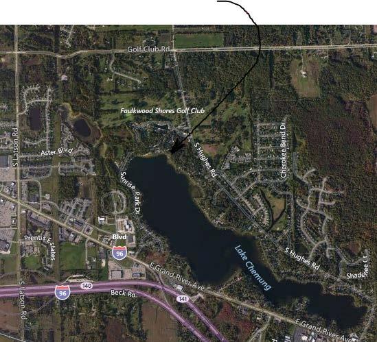
2 LAKE CHEMUNG DAM LOCATION MAP LAKE CHEMUNG DAM OUTLET LAKE CHEMUNG DAM
3 From: deq-wrd-qreq To: Steve Nagy Subject: RE: flood or low flow discharge request (ContentID ) Date: Friday, June 26, :42:54 PM This reply is being sent via only. We have estimated the flood frequency discharges requested in your of June 25, 2015 (Process No ), as follows: Tributary to Bogue Creek at Lake Chemung Control Structure, Dam ID 1980, Section 4, T2N, R5E, Genoa Township, Livingston County, has a total drainage area of 4.7 square miles and a contributing drainage area of 4.6 square miles. The design discharge for this dam is the 1% chance (100-year) flood. The 1% and 0.5% chance peak outflows are estimated to be 70 cubic feet per second (cfs) and 80 cfs, respectively. (Watershed Basin No. 32C Shiawassee). Please include a copy of this letter with your inspection report or any subsequent application for permit. These estimates should be confirmed by our office if an application is not submitted within one year. If you have any questions concerning the discharge estimates, please contact Ms. Susan Greiner, Hydrologic Studies and Dam Safety Unit, at , or by at: GreinerS@michigan.gov. If you have any questions concerning the hydraulics or the requirements for the dam safety inspection report, please contact Mr. Luke Trumble of our Dam Safety Program at , or by at: TrumbleL@michigan.gov Original Message----- From: snagy@fveng.com [mailto:snagy@fveng.com] Sent: Thursday, June 25, :53 AM To: deq-wrd-qreq Subject: flood or low flow discharge request (ContentID ) Requestor: Steve Nagy Company: Fleis & VandenBrink Address: 9475 Holly Road, Suite 201 City: Grand Blanc, MI Zip: Phone: Date: F1percent: Yes F0.5percent: Yes ContactAgency: None Selected ContactPerson: Watercourse: Lake Chemung Dam, Dam ID 1980 LocalName: CountyLocation: Livingston CityorTownship: Genoa Twp Section: 4 Town: T2N Range: R5E Location: Parkview Dr, 1250' west of S Hughes Road FFR1: Dam

4 MICHIGAN DEPARTMENT OF ENVIRONMENTAL QUALITY LAND AND WATER MANAGEMENT DIVISION DAM INSPECTION REPORT This form is to be used for inspection reports required by Part 307, Inland Lake Levels, for those dams that do not meet the size criteria as defined by Part 315, Dam Safety, of the Natural Resources and Environmental Protection Act, 1994 PA 451, as amended. Dams six (6) feet or more in height, as defined by Part 315, and impounding five (5) acres or more at the design flood elevation, must meet the inspection report format as outlined in Section of Part 315. A person failing to comply, or falsely representing dam conditions, is guilty of misconduct in office. DAM NAME Lake Chemung DAM ID 1980 COUNTY Livingston DATE OF INSPECTION 10/08/2015 DATE ELEVATION SET BY COURT 12/14/1925 NAME OF WATERBODY Lake Chemung LEGAL LEVEL (*see noted adjust.) SECTION, TOWN, RANGE Sec. 4 T _2N R 5E DRAWDOWN LEVEL (*see noted adjust.) LEVEL THIS DATE HIGH WATER MARK ELEVATION (Historical rec.) EARTH EMBANKMENTS LEFT EMBANKMENT FT. RIGHT EMBANKMENT FT. TOTAL LENGTH 50 FT. (LOOKING DOWNSTREAM) (previously noted) VEGETATIVE COVER EROSION SEEPAGE UPSTREAM CROWN DOWNSTREAM Seawall, grass and shoreline Gravel Roadway w/ grass Grass and brush. shoulders None None None None visible SLIDES, SLUMPS & CRACKS Very minor settlement in front of structure at sand buildup. No cracking or structure issues None visible None visible ANIMAL BURROWS None visible None visible None visible WAVE ACTION PROTECTION Seawall and sheeting on west. Steel sheeting on east, natural exposed shoreline beyond. Riprapped banks and at outlet pipe. REMARKS* Overall in good condition. Sheet piling has some corrosion. No inflow day of inspection. Good condition Riprapped channel immediately downstream of outlet in good condition. CONTROL STRUCTURE TYPE Fixed crest concrete and sheet piling YEAR CONSTRUCTED 2010 STRUCTURAL HEIGHT (top of dam elevation minus stream invert) 5 Ft LENGTH OF SPILLWAY 16.8 ft. (effective length) 28.9 ft total length FREEBOARD 1.5 Ft. HYDRAULIC HEIGHT (design flood elevation minus stream invert) 5 Ft. VERTICAL PIPE SIZE N/A HORIZONTAL PIPE SIZE 36 high x 60 span CMPA HEAD (normal headwater minus normal tailwater) 2 Ft DESCRIBE CONDITION OF THE FOLLOWING ITEMS. STOPLOG VALVES AND GATES (open and close to check condition): Check location of top stoplog in relation to top of riser pipe intake box or fixed crest, for leakage, and condition of stoplogs, valves and gates. N/A OUTLET PIPE: Check for damage from ice, logs, vandalism; inside discharge pipe for settlement and/or joint separation; condition of pipe coating. Corrugated arch pipe in good condition from 2010 installation. Joints good and no settlement observed.
5 CONTROL STRUCTURE (continued) CONCRETE STRUCTURE: Check for erosion; location of cracking or spalling. If old or new; settlement; need for crack repairs. Structure in good condition w/ no visible cracking or spalling. No flow due to low lake level. Structure base in good condition. Minor surface corrosion on sheet piling side walls. WALKWAY & RAILING: Check if in place or removed, condition, and if adequate protection provided. Good Condition. TRASHRACK OR LOG BOOM: Check if operable. N/A EMERGENCY SPILLWAY: Size, type, and condition. None INLET & OUTLET CHANNELS SIZE INLET Approx 15 ft to 18 ft +/- at Inlet (across skewed opening to lake) OUTLET 10 to 15 Ft EXISTING CONDITION Clear Clear at outlet EROSION None Visible No erosion. Recent 2010 riprap installation well maintained and stablized. DEBRIS & OBSTRUCTIONS Very minor sand buildup in front of structure. Normal minimal debris in structure, but no build-up to obstruct flow. Downstream channel clear beyond outlet and past pedestrian walkway bridge. RIPRAP PROTECTION None. (Sheeting along banks). Good condition. REMARKS* RECOMMENDATIONS List work needed, how to be done, by whom, estimated cost, source of funds, recommended completion date. If emergency, to what extent. ADDITIONAL COMMENTS. Previous lake level adjustment found during 2010 design and 2012 inspection for erroneous benchmark was corrected and assumed elevations noted with this report. Previous correction of Legal Lake Level from to indicated above. Inspection Ordered By: Brian Jonckheere, Drain Commissioner Livingston County Delegated Agent Daniel J. Cabage, P.E Holly Road, Suite 201 INSPECTOR'S NAME (PRINTED) ADDRESS Grand Blanc, MI SIGNATURE CITY, STATE, ZIP CODE P.E. REGISTRATION NO. TELEPHONE NUMBER Please submit this completed report and photographs of the dam, downstream channel, and deficiencies cited in the report to: DAM SAFETY PROGRAM LAND AND WATER MANAGEMENT DIVISION MICHIGAN DEPARTMENT OF ENVIRONMENTAL QUALITY PO BOX LANSING MI *NOTE: If space is inadequate for remarks, attach additional sheets as needed. EQP 4526 (Rev. 9/2004)

 at structure and Lake Chemung.")
6 Lake Chemung Dam Structure Standing at shoreline (upstream) looking at Lake Chemung Dam structure. Minor buildup at weir wall. Standing above protective railing on crown of dam looking south (upstream) at structure and Lake Chemung. Inspection Date: 10/08/2015 Page 1 of 3
 at riprapped channel.")

7 Lake Chemung Dam Structure Standing above protective railing at crown of dam looking north (downstream) at riprapped channel. From structure invert looking south downstream at condition of 36 x 60 CMPA outlet pipe. Inspection Date: 10/08/2015 Page 2 of 3


8 Lake Chemung Dam Structure West steel sheet piling wall and minor surface corrosion. Looking south (upstream) at outlet pipe end section and riprapped channel. Inspection Date: 10/08/2015 Page 3 of 3
9
10

11
12
13
14
15
16 Memorandum To: Dam Safety Program Water Management Division Michigan Department of Environmental Quality From: G. John Tanner, PE CC: Rod Soos, Dam Operator Livingston County Drain Commissioners Office Date: October 30, 2012 RE: Lake Chemung Legal Lake Level Revision (Dam ID # 1980) On behalf of the Livingston County Drain Commissioners office, we are forwarding you information to initiate the process of correcting/revising the Lake Chemung Legal Lake Level. The actual lake level of the Lake Chemung dam structure became an issue for discussion after the structure was rebuilt in 2010 at the same elevation that it has been for many years. An investigation was conducted and it was determined that the original legal level was established at 3.2 feet below a certain benchmark on a black oak tree which was later erroneously documented as being , when it was actually The attached information contains the history of the proposed legal lake level and the actual lake level elevation as originally constructed and duplicated in The first two Documents are circuit court orders identifying the legal lake level as 3.2 feet below a certain bench mark on a 14 inch diameter black oak adjacent to the outlet. The third and fourth documents are letters from 1954 indicating a problem was recognized within 2 years of the dam construction and the fifth document indicates that it was still an issue in 1956 two years later. The next two pages show the survey work done in 1949 for the construction of the dam. According to the notes, it appears that there were problems with the benchmarks. The next four pages are the dam inspection reports from 1971 & 1975 that indicate on them that there is a discrepancy with the elevation. This note was on every inspection after that until the 1997 inspection which is the last two pages in the attachment. For whatever reason, this discussion was dropped and never indicated on any of the subsequent inspections since As stated above, the legal level is currently identified as The actual weir elevation is This is what it has been since 1952, and based upon the attached documentation, has always been the structure elevation. Also attached are the as-built plans from the recent 2010 dam structure reconstruction.