The Rasor Platform Rapid Assessment and Spatialisation of Risk WHO WE ARE
|
|
|
- Holly Paul
- 5 years ago
- Views:
Transcription

1 The Rasor Platform Rapid Assessment and Spatialisation of Risk WHO WE ARE


2 WHERE WE ARE Founding: Partnership:

3 Increasing number of major disasters, and associated losses, worldwide. How to reduce these impacts? MITIGATION PREPAREDNESS PREVENTION RISK ASSESSMENT RASOR is a platform to perform multi-hazard risk analysis for the full cycle of disaster management, making scenario based predictions to support both short and long-term risk-related decisions. What do DRM Users Need? Up-to-date spatialised view of hazard extent (across several hazards) Up-to-date information on exposure of people and assets (and ability to project change) Comprehensive information on past disasters (to assist in risk identification) Ability to modify key parameters and project impact Ability to project cumulative effect of risk and correlations Ability to integrate analysis in a single tool Ability to produce information (layers) for ingestion in other tools


4 RASOR distinctive features RASOR distinctive features First Pivot Step Derived Indicators


5 RASOR distinctive features Web Platform, plug-in, mobile app Web Platform Q-GIS plug-in Mobile App


6 QGIS Exposure plug-in Mobile Apps Field data collection


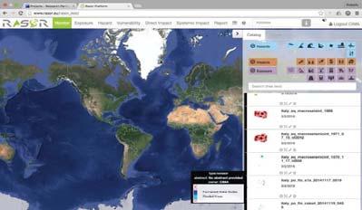
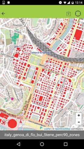
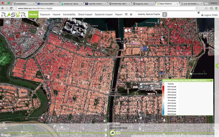
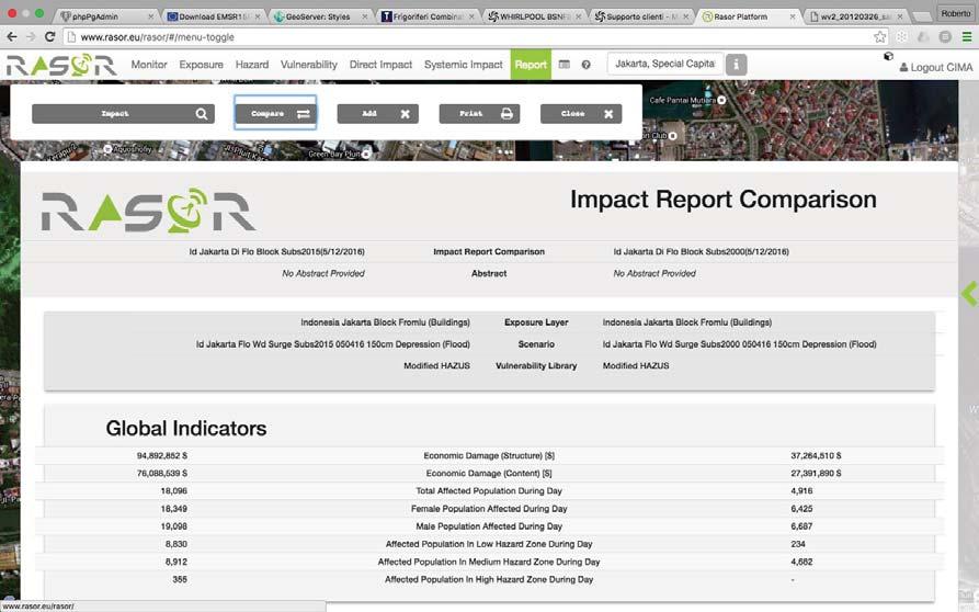
7 Rasor structure
8 Graphical User Interface Guided process in building scenarios EXPOSURE layers HAZARD layers MONITOR VULNERABILITY functions Direct IMPACT Systemic IMPACT REPORT EO Contribution Satellite data are a critical component of the RASOR tool, both as input for scenario building and as feedback for validation: Optical/Radar to extract exposure information Interferometric data to monitor ground deformation (geohazards) EO Proxies to have an indication of vulnerability Validate numerical models (flood foot prints, grading maps)


")
9 TanDEM-X DEM TanDEM-X SRTM 30m12m Earth Observation & Exposure Features from: In-situ data (cadastral) Satellite Data Crowed Source


![Height of windows/openings on the basement above the ground [ not present, meters] User knowledge required 9. Presence of a split level [yes/no] User knowledge required 10.](/docs-images/96/126602857/images/10-4.jpg "Height of walls and other retaining structures above the ground [ not present, meters] Structure height 11. Foundation type 11.1 Piers User knowledge required 11.2 Slab 12. Structural type 12.")
10 Earth Observation & Vulnerability From SENSUM Project EO Proxies for Vulnerability (Earthquakes and Landslides) Medium Resolution Unsupervised built-up area Age of built-up area (evolution in time) High Resolution Building footprints Building height Building regularity Building alignment Building density Roof type!!low!density!!high!density! BUILDINGS ATTRIBUTES useful for FLOOD DAMAGE CURVES 1. Use 1.1 Residential Upper middle and middle class Lower middle class Skilled working class Working class and lowest level of subsistence 1.2 Commercial Professional business Shops/Supermarkets Industrial 1.3 Public Hospital/ Health structure School/ Educational structure Government facility 1.4 Touristic Museum Hotel Religious building 2. Construction material 2.1 Wood frame 2.2 Steel Frame 2.3 Masonry PROXIES from REMOTE SENSING -Open spaces -Land use -Roof type -Building footprint -Land use -Roof type -Buiding age 2.4 Concrete bearing wall structures 3. First floor elevation above the ground [meters] User knowledge required 4. Height of doors and openings above the ground [meters] User knowledge required 5. Orientation of doors and openings (to be compared to water direction) 5.1 N User knowledge required 5.2 N/W 5.3 W An approximative evaluation 5.4 S/W can be done considering 5.5 S -Street network 5.6 S/E -Building footprint 5.7 E 5.8 N/E 6. Number of storeys Building height 7. Presence of a basement [yes/no] User knowledge required 8. Height of windows/openings on the basement above the ground [ not present, meters] User knowledge required 9. Presence of a split level [yes/no] User knowledge required 10. Height of walls and other retaining structures above the ground [ not present, meters] Structure height 11. Foundation type 11.1 Piers User knowledge required 11.2 Slab 12. Structural type 12.1 Detached -Building height 12.2 Semi-detached -Roof type 12.3 Terraced 12.4 Flat -Building footprint 12.5 Bungalow 13. Age of buildings 13.1 pre Building age post 1985


11 EO & hazards interaction (subsidence + flood)


12 RASOR CoP (#RASORCoP) DATA CONNECTING MODELS PEOPLE
13 Thank you