Atlantic Coast of New York East Rockaway Inlet to Rockaway Inlet and Jamaica Bay, NY
|
|
|
- Adrian Gallagher
- 6 years ago
- Views:
Transcription


1 Atlantic Coast of New York East Rockaway Inlet to Rockaway Inlet and Jamaica Bay, NY Draft Reformulation Public Information October 2016 US Army Corps of Engineers
2 Presentation Outline Project Overview & History Problem Statement Plan Formulation Process Tentatively Selected Plan Shorefront features Inundation Features Tie-In features Residual Risk features Environmental Analysis Next steps 2
3 Meeting Purpose Public Information Session & NEPA Meeting Provide an update on the Reformulation Study and Tentatively Selected Plan (TSP) Provide an opportunity for feedback on: Tentatively Selected Plan Alternatives considered in arriving at the TSP 3
4 Project Partners NY State Department of Environmental Conservation (NYSDEC) New York City Mayor s Office of Recovery and Resiliency Department of Parks and Recreation Department of Environmental Protection National Park Service, Gateway (Cooperating Agency)

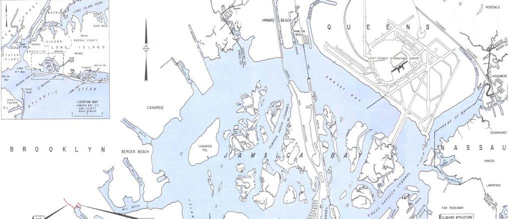
5 Study Area 5
6 Reformulation Goals Recommend long-term coastal storm risk reduction for Rockaway and Jamaica Bay Address multiple risks in a comprehensive system for Rockaway and Jamaica Bay that is Engineeringly Feasible Economically Justified Environmentally Acceptable 6
7 Risks Flooding (inundation) along Atlantic Ocean Coast and Jamaica Bay Wave Damage Beach Erosion Effects of Sea Level Change
8 Problem Statement Coastal Storm Risk Vulnerability Structures exposed to inundation, waves and erosion Naturally low-lying topography inundation occurs across broad areas Densely populated urban area Extensive low-lying infrastructure Critical infrastructure within inundation impact areas Degraded coastal ecosystems undermine natural resiliency of the area >41,000 structures at risk of inundation for 1% event 8

9 Scale of the Flooding Problem Blue illustrates current 1% annual chance of flooding Purple illustrates 1.3 feet of Relative Sea Level Change in 2070, (mid-range SLC) added to the 1% flooding 9


10 Sand Movement and Erosion Simulation +16 years
11 Original Project (1970s) Project Authorized in 1965 as a Beach Erosion Control and Hurricane Protection Project Beach Erosion Control Features: Beach Berm at +10 ft Mean Sea Level (MSL) 5M Cubic Yards of sand place for initial construction Renourishment for a period of 10 years Hurricane Protection Features: Never Constructed and Subsequently De-authorized Hurricane Barrier w/ Navigation gate across Rockaway Inlet Floodwall at +18 ft MSL, for 7.7 miles along Rockaway 11
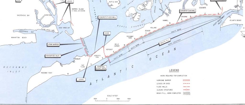
12 Original Authorized Project 12
13 Original Project (1970s) 1974 authorization authorized separate construction of beach erosion control portion plus 10 years of renourishment The Hurricane Protection Features were de-authorized by Congress Constructed in Terminal groin added at Beach 149 th Street in 1979 Project renourished regularly through 1987, and in 1996, 2000, and 2004 Due to lack of renourishment, the beach was below design size when Sandy hit 13
14 Original Authorized Project Cross-Section As a beach erosion control project no dune feature or wall to offer protection against surge (flooding) 14
15 Planning Process Overview Rockaway Project Area formulated as a system, considering shorefront and bay - First Planning step is to evaluate and screen measures - Second Planning Step is to compare alternatives and identify the Tentatively Selected Plan - Following the Draft Report and EIS additional feasibility-level design is conducted on TSP.


 bypassing and")

16 Storm Risk Management Measures Coastal storm risk management can be achieved through a variety of engineered features, designed as appropriate for each project area. Features can include hurricane storm surge barriers hurricane dunes and levees seawalls revetments groins breakwaters beaches and dunes (beach nourishment) bypassing and backpassing of sand non-structural measures such as house-raising, road raising, relocations and buyouts.
17 A - No Action Alternative Final Array of Alternatives B - Non-Structural Alternative C - Rockaway Storm Surge Barrier (2 Possible Alignments) Beachfill with reinforced dune Groins & Groin extensions Barrier with navigation and sector gates Tie In Features D - Jamaica Bay Perimeter Plan Beachfill with reinforced dune Groins & groin extensions Living Shoreline and/or T-Wall where appropriate Smaller inlet closure gates to reduce wall length


18 BUILDING STRONG

19 Tentatively Selected Plan
20 Elements Common to All Alternatives Atlantic Shorefront Features (Composite Seawall, Beachfill, Groins) Atlantic Shorefront East and West Tie-ins* Rockaway Bayside Tie-in* Coney Island Tie-in* * Alternative tie-ins will be developed further during detailed design 20
 and new groin at Beach 34 th Typical groin section Typical groin layout Groin Construction 34th St new groin - 526 ft 37th St extend groin - 175 ft 40th St extend groin")
21 Tentatively Selected Plan (Shorefront Component) Composite Seawall, beach berm Construction of 12 new groins between Beach 90th to Beach 122 nd Enhancement of existing groin field from Beach 36th to Beach 49th (extending groins) and new groin at Beach 34 th Typical groin section Typical groin layout Groin Construction 34th St new groin ft 37th St extend groin ft 40th St extend groin ft 43rd St extend groin - 75 ft 46th St extend groin ft 49th St extend groin ft 92nd St new groin ft 95th St new groin ft 98th St new groin ft 101st St new groin ft 104th St new groin ft 106th St new groin ft 108th St new groin ft 110th St new groin ft 113th St new groin ft 115th St new groin ft 118th St new groin ft 121st St new groin ft

22 Shorefront Component includes Initial sand placement and renourishment 50 years Red line indicates previous Authorized project elevation

23 Composite Seawall Cross-Section 23

24 Barrier Alignment Alternatives Three alignments of the storm surge barrier originally considered - Hydrodynamic modeling undertaken for design of openings - Effects of scour on Gil Hodges Bridge eliminated C-1W - Impacts to existing utilities considered C-1E is the preferred alignment, C-2 is close in comparison Preliminary Water Quality modeling undertaken to evaluate plans Additional modeling to be undertaken for the final design


25 Surge Barrier Details Hurricane Barrier Alternative Alignment Gate Opening Aggregate Length Alignment Total Opening (ft) Number of 100-foot Vertical Lift Gates Number of 200-foot Sector Gates C-1E 1, C-2 1, Both Alignments Maximum tidal amplitude change of 0.2 feet, Minimal change to flow speeds and direction Oosterscheldekering Storm Surge Barrier with lift gates Source: ( Rijkswaterstaat / Harry van Reeken) Spijkenisse - Hartelkering Storm Surge Barrier with sector gates (credit: Quistnix!) 25

26 Lake Borgne, New Orleans Surge Barrier built by the USACE in 2011 (1.8 miles long) 26
27 Residual Risk Features Areas vulnerable to SLC or high frequency events will be protected in the short term prior to construction of the barrier NNBFs and some structures identified Small scale Non-Structural solutions will be explored in final design 27


28 Typical Residual Risk Measures Generic measures are assigned considering: Shoreline Type and Condition Alignment FLOOD SIDE Retrofit L-Wall LAND SIDE Land Use Generic measure is either: Retrofit Existing Structure New Construction Cost developed for each project based on measure and length FLOOD SIDE Retrofit Crown Wall LAND SIDE
29 Bulkhead Generic Residual Risk Measures (cont d) New I-Wall FLOOD SIDE LAND SIDE FLOOD SIDE LAND SIDE Revetment Berm FLOOD SIDE LAND SIDE FLOOD SIDE LAND SIDE
30 Edgemere Residual Risk Concept BUILDING STRONG
31 Mott Basin Residual Risk Concept 31 BUILDING STRONG
32 Cost Breakdown Construction, Mitigation, and Real Estate Costs Alternative C-1E Alternative C-2 Alternative D Construction $3,328,135,000 $3,361,337,000 $4,467,352,000 Mitigation $90,833,000 $75,783,000 $123,383,000 Real Estate $29,436,000 $17,386,000 $179,955,000 First Cost Total $3,448,404,000 $3,454,506,000 $4,770,690,000 IDC $333,029,000 $336,274,000 $424,262,000 Total Construction Cost $3,781,433,000 $3,790,780,000 $5,194,952,000 FY 2016, 50 year study period, discount rate 32
33 Annual Costs Annual Costs Alternative C-1E Alternative C-2 Alternative D Construction Renourishment $150,474,000 $150,846,000 $206,722,000 $5,740,000 $5,740,000 $5,740,000 OMRR&R Total AAEQ $7,424,000 $7,124,000 $14,954,000 $163,638,000 $163,710,000 $227,416,000 FY 2016, 50 year study period, discount rate 33
34 Project Costs and Economics Alternative Plan Benefit Cost Ratio Plan Total Cost Benefits Net Benefits BCR C-1E $163,638,000 $509,233,000 $345,595, C-2 $163,710,000 $509,233,000 $345,523, D $227,416,000 $497,582,000 $270,166, FY 2016, 50 year study period, discount rate The TSP is the NED Plan, identified as the plan that has highest net benefits

, ends as soon as each element is constructed Unavoidable,")
35 Consideration of Environmental Impacts Impacts Considered: Benthic Communities, Fisheries, Shorebirds, Water Quality, Air Quality and Noise, Cultural Resources, Aesthetics, Surfing, Fishing, Beach Usage. Impacts Avoided or Minimized Benthic: Short term, recovery expected within months nearshore and 1.5 to 2.5 years offshore following construction Fisheries: No long-term impacts expected, will generally avoid construction area Shorebirds/Endangered Species: No construction during breeding season Avoidance and enhancement of existing foraging/nesting habitats Water Quality: Short term turbidity (including impacts to dissolved oxygen), ends as soon as each element is constructed Unavoidable, Minimal &Temporary Recreational and Environmental Impacts Beach Access: Temporary disruption to beach access via walkovers over the Aesthetics: Potential impacts to view of beach from north side of the dune Surfing and Fishing: Will be temporary and will dissipate as the beach returns to equilibrium Beach Usage: Impacts end as construction moves along Beach Groins/Jetties: Impact local shoreline sand supply, disrupt benthic habitat, provide vertical and structural habitat for many marine organisms; Potential adverse effect to buried cultural resources Air Quality and Noise: Temporary impacts, during 24-7 construction only Aesthetics: New sand similar to the existing beach. Seawalls: Reduce aquatic-terrestrial connectivity. Reduce spawning habitat for forage fish. Potential loss of upper beach and backshore altered sediment transport (loss of beach shoreward of the structure); Potential adverse effects to buried cultural resources Storm Surge Barrier Impacts: Potential to affect tidal hydraulics and water quality parameters such as temperature, dissolved oxygen, nutrient concentrations, etc. Impacts to bay bottom, potentially limiting wetland areas along the shoreline area Adverse effects to Gateway National Recreation Area historic districts
36 Hydrodynamic modeling to date: 1) Tidal Amplitude impacts Barrier Analysis Identified reductions in tidal amplitude of less than 0.2 feet Results consistent over full 35-day simulation period, and for all hurricane barrier alignments and configurations evaluated for the TSP 2) Jamaica Bay Eutrophication Model Bay specific model to assess impacts in greater detail. 36
37 Next Steps Public and agency input on features, locations and scales Refine design and evaluation of specific plans Detailed, coordinated Water Quality Modeling Refine design Identify scale of barrier and tie ins Department of Interior (Gateway) agreement with plan Final Report and Environmental Impact Statement
38 Implementation The Selected Plan will be built incrementally, Atlantic Shoreline will be in the first phase Significant Federal funding is available for construction (Sandy Funding to USACE for projects like this totals $3.5B) 38
39 Schedule Draft General Reevaluation Report available for public and agency review: November 17, 2016 Final Report (June 2017) must be reviewed and approved both internally within the USACE and externally, including local, state, and other Federal oversight Construction start of first phase (Targeted for 2019) will depend on length of reviews and approvals, and relative complexity of design 39
40 Local Sponsor Responsibilities Local Sponsor Must cost-share construction and renourishment Must commit to doing O&M Must indemnify State and Federal Governments Must obtain all necessary real estate 40
41 Operation and Maintenance Local Sponsor must maintain project once built Maintain public access Prohibit excavation and alterations Grade and reshape beach to original elevations to repair erosion Operate and Maintain the Storm Surge Barriers Conduct quarterly inspections and take beach width measurements Send quarterly inspection reports to State and Corps Conduct pre-storm & post-storm inspections Participate in yearly inspection with State and Corps 41
42 Real Estate Required Perpetual beach easements for all parcels where sand is placed Fee acquisition required for structural components 42

43 Public Access Overview Federal funding requires public access open to all Public accessways to beaches must be within ¼ of a mile in each direction Local Sponsor responsible for developing a Public Access Plan

44 Questions
NEW YORK NEW JERSEY HARBOR AND TRIBUTARIES COASTAL STORM RISK MANAGEMENT
 NEW YORK NEW JERSEY HARBOR AND TRIBUTARIES COASTAL STORM RISK MANAGEMENT 237 217 200 80 237 217 200 119 FEASIBILITY 237 217 200 STUDY 27 255 0 163 131 239 110 112 62 102 130 National Environmental Policy
NEW JERSEY BACK BAYS COASTAL STORM RISK MANAGEMENT INTERIM FEASIBILITY STUDY AND ENVIRONMENTAL SCOPING DOCUMENT. Executive Summary 1 March 2019
 NEW JERSEY BACK BAYS COASTAL STORM RISK MANAGEMENT INTERIM FEASIBILITY STUDY AND ENVIRONMENTAL SCOPING DOCUMENT Executive Summary 1 March 2019 Document Overview This U.S. Army Corps of Engineers (USACE)
NEW YORK NEW JERSEY HARBOR AND TRIBUTARIES COASTAL STORM RISK MANAGEMENT
 NEW YORK NEW JERSEY HARBOR AND TRIBUTARIES COASTAL STORM RISK MANAGEMENT 237 217 200 80 237 217 200 119 FEASIBILITY 237 217 200 STUDY 27 255 0 163 131 239 110 112 62 102 130 National Environmental Policy
NEW YORK NEW JERSEY HARBOR AND TRIBUTARIES COASTAL STORM RISK MANAGEMENT
 NEW YORK NEW JERSEY HARBOR AND TRIBUTARIES COASTAL STORM RISK MANAGEMENT 237 217 200 80 237 217 200 119 FEASIBILITY 237 217 200 STUDY 27 255 0 163 131 239 110 112 62 102 130 National Environmental Policy
New Jersey Back Bays Coastal Storm Risk Management Feasibility Study. Ocean and Burlington Counties Mayor s Meeting Toms River, NJ June 19, 2018
 New Jersey Back Bays Coastal Storm Risk Management Feasibility Study Ocean and Burlington Counties Mayor s Meeting Toms River, NJ June 19, 2018 1 State of New Jersey Shore Protection Program State of New
Atlantic Coast of NY, East Rockaway Inlet to Rockaway Inlet and Jamaica Bay APPENDIX N COASTAL ZONE MANAGEMENT
 Atlantic Coast of NY, East Rockaway Inlet to Rockaway Inlet and Jamaica Bay APPENDIX N COASTAL ZONE MANAGEMENT Hurricane Sandy General Reevaluation Report August 2016 New York (and New York City Local
REVISED DRAFT Integrated Hurricane Sandy General Reevaluation Report and Environmental Impact Statement Atlantic Coast of New York
 REVISED DRAFT Integrated Hurricane Sandy General Reevaluation Report and Environmental Impact Statement Atlantic Coast of New York East Rockaway Inlet to Rockaway Inlet and Jamaica Bay August 2018 EXECUTIVE
Sea Level Change Considerations on Federal Coastal Storm Damage Reduction Projects
 Sea Level Change Considerations on Federal Coastal Storm Damage Reduction Projects Jason Engle, P.E. Matt Schrader, P.E. Presented by: Jason Engle Jacksonville District U.S. Army Corps of Engineers ENGINEERING
U.S. Army Corps of Engineers New Jersey Back Bays Flood Risk Management Planning Workshop. Background Reading/Pre Workshop Activity
 U.S. Army Corps of Engineers New Jersey Back Bays Flood Risk Management Planning Workshop Background Reading/Pre Workshop Activity Introduction The U.S. Army Corps of Engineers (USACE), the USACE National
Coastal Texas Protection and Restoration Study
 Coastal Texas Protection and Restoration Study SSPEED Center Conference Sheri Willey Project Manager Galveston District April 26, 2016 US Army Corps of Engineers US Army Corps of Engineers BUILDING STRONG
Mississippi Coastal Improvements Program A Comprehensive Plan for Coastal Resilience
 Mississippi Coastal Improvements Program A Comprehensive Plan for Coastal Resilience 200 Coastal Resilience Symposium 26 May 200 US Army Corps of Engineers BUILDING STRONG Mississippi Coastal Improvements
Fire Island Inlet to Montauk Point New York
 Fire Island Inlet to Montauk Point New York Draft General Reevaluation Report U.S. Army Corps of Engineers New York District July 2016 This page intentionally left blank July 2016 1 Draft General Reevaluation
TOWN OF RHINEBECK RESOLUTION
 TOWN OF RHINEBECK RESOLUTION 2018197 REQUESTING AN ETENSION OF THE SCOPING COMMENT PERIOD WITH ADDITIONAL PUBLIC INFORMATION AND SCOPING MEETINGS, FOR THE NY/NJ HARBOR & TRIBUTARIES COASTAL STORM RISK
CITY OF NORFOLK COASTAL STORM RISK MANAGEMENT STUDY
 1 CITY OF NORFOLK COASTAL STORM RISK MANAGEMENT STUDY 255 255 255 File Name 237 237 237 217 217 217 200 200 200 0 0 0 163 163 163 131 132 122 239 65 53 80 119 27 252 174.59 110 135 120 112 92 56 62 102
APPENDIX A SECTION 404(B)(1) EVALUATION TYBEE ISLAND, GEORGIA SHORE PROTECTION PROJECT RENOURISHMENT
(1) EVALUATION TYBEE ISLAND, GEORGIA SHORE PROTECTION PROJECT RENOURISHMENT") APPENDIX A SECTION 404(B)(1) EVALUATION TYBEE ISLAND, GEORGIA SHORE PROTECTION PROJECT 2014-2015 RENOURISHMENT U.S. ARMY CORPS OF ENGINEERS SAVANNAH DISTRICT JUNE 2014 This page intentionally blank. SECTION
APPENDIX A SECTION 404(B)(1) EVALUATION TYBEE ISLAND, GEORGIA SHORE PROTECTION PROJECT 2014-2015 RENOURISHMENT U.S. ARMY CORPS OF ENGINEERS SAVANNAH DISTRICT JUNE 2014 This page intentionally blank. SECTION
Asharoken Coastal Storm Damage Risk Reduction Feasibility Study
 Asharoken Coastal Storm Damage Risk Reduction Feasibility Study Megan Jadrosich Project Manager U.S. Army Corps of Engineers Project Progress New York District Public Update April 23, 2009 Outline Summary
COASTAL RESILIENCE CONSIDERING CLIMATE EXTREMES AND VARIABILITY
 COASTAL RESILIENCE CONSIDERING CLIMATE EXTREMES AND VARIABILITY 255 255 255 Jane McKee Smith, PhD, PE Senior Research Scientist, Hydrodynamic Phenomena Engineer Research & Development Center, Coastal &
15A NCAC 07H.0308 SPECIFIC USE STANDARDS FOR OCEAN HAZARD AREAS (a) Ocean Shoreline Erosion Control Activities: (1) Use Standards Applicable to all
 Ocean Shoreline Erosion Control Activities: (1) Use Standards Applicable to all") 15A NCAC 07H.0308 SPECIFIC USE STANDARDS FOR OCEAN HAZARD AREAS (a) Ocean Shoreline Erosion Control Activities: (1) Use Standards Applicable to all Erosion Control Activities: (A) All oceanfront erosion
15A NCAC 07H.0308 SPECIFIC USE STANDARDS FOR OCEAN HAZARD AREAS (a) Ocean Shoreline Erosion Control Activities: (1) Use Standards Applicable to all Erosion Control Activities: (A) All oceanfront erosion
Engineering with Nature for Coastal Resilience
 Engineering with Nature for Coastal Resilience Dr. Todd S. Bridges Senior Research Scientist, Environmental Science U.S. Army Engineer Research and Development Center, U.S. Army Corps of Engineers todd.s.bridges@usace.army.mil
Coastal Texas Protection and Restoration Project
 Coastal Texas Protection and Restoration Project Sharon Tirpak / Sheridan Willey / Janelle Stokes Project Management / Planning / Environmental USACE, Galveston District August 2014 US Army Corps of Engineers
Virginia Beach Comprehensive Sea Level Rise and Recurrent Flooding Planning Study
 1 Virginia Beach Comprehensive Sea Level Rise and Recurrent Flooding Planning Study Policy Recommendations and City-wide Flood Protection Strategies January 15, 2019 2 Agenda Project Overview Hazards and
REVISED DRAFT Integrated Hurricane Sandy General Reevaluation Report and Environmental Impact Statement. Atlantic Coast of New York
 REVISED DRAFT Integrated Hurricane Sandy General Reevaluation Report and Environmental Impact Statement Atlantic Coast of New York East Rockaway Inlet to Rockaway Inlet and Jamaica Bay Appendix G Public
Sabine Pass to Galveston Bay, Texas Coastal Storm Damage Reduction and Ecosystem Restoration Project. An Update
 Sabine Pass to Galveston Bay, Texas Coastal Storm Damage Reduction and Ecosystem Restoration Project An Update Sharon Manzella Tirpak Project Manager 25 September 2013 US Army Corps of Engineers Study
02 APRIL PUBLIC NOTICE U.S. Army Corps of Engineers, Savannah District
 DEPARTMENT OF THE ARMY U.S. ARMY CORPS OF ENGINEERS, SAVANNAH DISTRICT 100 W. OGLETHORPE AVENUE SAVANNAH, GEORGIA 31401-3604 Planning Branch TO WHOM IT MAY CONCERN: 02 APRIL 2019 PUBLIC NOTICE U.S. Army
NATIONAL OCEAN SERVICE
 NATIONAL OCEAN SERVICE Jeff Payne, Ph.D., Office for Coastal Management Steve Thur, Ph.D., Acting Director National Centers for Coastal Ocean Science February 23, 2017 NATIONAL OCEAN SERVICE oceanservice.noaa.gov
CHAPTER 7. San Dieguito River Flooding Adaptation
 CHAPTER 7 San Dieguito River Flooding Adaptation This chapter includes a range of adaptation measures to address vulnerabilities from flooding along the San Dieguito River, including the river valley,
DOWNTOWN MONTAUK STABILIZATION PROJECT
 DOWNTOWN MONTAUK STABILIZATION PROJECT EVALUATION OF A STABILIZATION PLAN FOR COASTAL STORM RISK MANAGEMENT IN RESPONSE TO HURRICANE SANDY & PUBLIC LAW 113-2 404(B)1 EVALUATION REPORT ATTACHMENT D TO THE
COASTAL TX PROTECTION AND RESTORATION FEASIBILITY STUDY
 COASTAL TX PROTECTION AND RESTORATION FEASIBILITY STUDY Stakeholders Forum Dr. Kelly Burks-Copes, Project Manager Mr. Tony Williams, Coastal Resources US Army Corps of Engineers, Galveston District Texas
ATTACHMENT 2 PROJECT NEED AND JUSTIFICATION
 ATTACHMENT 2 PROJECT NEED AND JUSTIFICATION INTRODUCTION The Project includes providing erosion control and shoreline stabilization measures including beach nourishment, maintenance dredging and bypassing,
AGENCY: Department of the Army; Corps of Engineers; and Texas Commission on Environmental Quality
 DEPARTMENT OF THE ARMY GALVESTON DISTRICT, CORPS OF ENGINEERS P. O. BOX 1229 GALVESTON, TEXAS 77553-1229 April 11, 2017 AGENCY: Department of the Army; Corps of Engineers; and Texas Commission on Environmental
Appendix D 404(b) Analysis
 Analysis") Appendix D 404(b) Analysis Appendix D - Evaluation of Section 404(b)(1) Guidelines I. Project Description A. Location: Delaware Bay and bayshore communities (Pickering Beach, Kitts Hummock, Bowers Beach,
Appendix D 404(b) Analysis Appendix D - Evaluation of Section 404(b)(1) Guidelines I. Project Description A. Location: Delaware Bay and bayshore communities (Pickering Beach, Kitts Hummock, Bowers Beach,
Notice of Availability (NOA) of the Draft Environmental Impact Statement. (DEIS) and the Announcement of a Public Hearing for the Installation of a
 of the Draft Environmental Impact Statement. (DEIS) and the Announcement of a Public Hearing for the Installation of a") This document is scheduled to be published in the Federal Register on 08/28/2015 and available online at http://federalregister.gov/a/2015-21282, and on FDsys.gov BILLING CODE: 3720-58 DEPARTMENT OF DEFENSE
This document is scheduled to be published in the Federal Register on 08/28/2015 and available online at http://federalregister.gov/a/2015-21282, and on FDsys.gov BILLING CODE: 3720-58 DEPARTMENT OF DEFENSE
CHAPTER 7. San Dieguito River Flooding Adaptation
 CHAPTER 7 San Dieguito River Flooding Adaptation This chapter includes a range of adaptation measures to address vulnerabilities from flooding along the San Dieguito River, including the river valley,
Sea Level Rise Impacts on Municipal Stormwater Systems in Hampton Roads
 VIRGINIA D.C. MARYLAND CHAPTER Sea Level Rise Impacts on Municipal Stormwater Systems in Hampton Roads Presentation at the APWA Mid-Atlantic Chapter May Regional Conference Virginia Beach, Virginia May
Issuing Office: CELRB-PM-EA Published: 22 FEB 2019 Notice No: SANDUSKY-19 Expires: 25 MAR 2019
 Public Notice Issuing Office: CELRB-PM-EA Published: 22 FEB 2019 Notice No: SANDUSKY-19 Expires: 25 MAR 2019 OPERATION AND MAINTENANCE DREDGING AND DREDGED SEDIMENT PLACEMENT SANDUSKY HARBOR ERIE COUNTY,
GREAT KILLS HARBOR, STATEN ISLAND, NEW YORK FEDERAL NAVIGATION PROJECT MAINTENANCE DREDGING
 Public Notice In replying refer to: Public Notice No. GREAT KILLS HARBOR FY13 Published: April 30, 2013, Expires: May 30, 2013 New York District 26 Federal Plaza New York, N.Y. 10278 ATTN: CENAN-OP-ST
Charleston Harbor Post 45 Draft Integrated Feasibility Report/Environmental Impact Statement Executive Summary
 Charleston Harbor Post 45 Draft Integrated Feasibility Report/Environmental Impact Statement i U.S. ARMY CORPS OF ENGINEERS NAVIGATION MISSION Provide safe, reliable, efficient, and environmentally sustainable
Public Notice U.S. ARMY CORPS OF ENGINEERS, GALVESTON DISTRICT AND TEXAS COMMISSION ON ENVIRONMENTAL QUALITY
 Public Notice U.S. Army Corps Permit Application No: SWG-2000-02888 Of Engineers Date Issued: 3 April 2018 Galveston District Comments Due: 3 May 2018 U.S. ARMY CORPS OF ENGINEERS, GALVESTON DISTRICT AND
LEE COUNTY, FLORIDA GASPARILLA ISLAND SEGMENT SHORE PROTECTION PROJECT 2013 BEACH RENOURISHMENT POST CONSTRUCTION MONITORING REPORT.
 LEE COUNTY, FLORIDA GASPARILLA ISLAND SEGMENT SHORE PROTECTION PROJECT 2013 BEACH RENOURISHMENT POST CONSTRUCTION MONITORING REPORT August 2014 U.S. ARMY CORPS OF ENGINEERS JACKSONVILLE DISTRICT Table
PUBLIC INFORMATION MEETING Rahway River Basin Flood Risk Management Feasibility Study
 PUBLIC INFORMATION MEETING Rahway River Basin Flood Risk Management Feasibility Study COL Paul E. Owen District Engineer U.S. Army Corps of Engineers New York District New Jersey Department of Environmental
2015 HDR, Inc., all rights reserved.
 2015 HDR, Inc., all rights reserved. Sandy Raises the Yards Permitting Raises the NEPA Bar MTA-NYCT 207th St Yard Flood Mitigation / Resiliency Project Environmental Railroad Conference November 1-2, 2016
Everglades Restoration Climate Program
 Sea Level Change and Long Range Water Resources Planning for Florida Everglades Restoration Climate Program Change Application Concerns of USACE and Guidance Draft Sea Level on Sea Rise Level Planning
Where the Ocean Meets Land. Coastal Engineering
 Where the Ocean Meets Land Coastal Engineering Photo credit : Rio Tinto Alcan Our Expertise MARINAS AND HARBOURS Design and repair of breakwaters Sedimentation and dredging studies Navigation guidelines
Honorable Louise Slaughter
 NY-25 Honorable Louise Slaughter New York State 114th Congress 25th Congressional District & & 2 & 1, O&M, Irondequoit Harbor 2, O&M, Rochester Harbor 3, GI, Lake Ontario Coastal Resiliency 4, IIS, Braddock
VILLAGE OF BALD HEAD ISLAND SHORELINE PROTECTION PROJECT DRAFT ENVIRONMENTAL IMPACT STATEMENT
 VILLAGE OF BALD HEAD ISLAND SHORELINE PROTECTION PROJECT DRAFT ENVIRONMENTAL IMPACT STATEMENT Prepared By: U.S. Army Corps of Engineers Wilmington District and Land Management Group, Inc. (Third Party
The State of New Jersey s Shore Protection Program
 Oakwood Beach Storm Damage Reduction Project NJDEP-Bureau of Coastal Engineering Glenn Golden, Project Manager U.S. Army Corps Civil Works Programs Branch Dwight Pakan, Project Manager, Philadelphia District
Coastal Hazards Vulnerability and Fiscal Impact Study Report:
 Agenda Item B.1 Coastal Hazards Vulnerability and Fiscal Impact Study Report: Vulnerability Assessment and Adaptation Strategies Review October 12, 2015 Planning Commission Meeting Presentation by: Anne
RESTORE Act Planning. Kyle Graham Executive Director CPRA. November 12, committed to our coast
 RESTORE Act Planning Kyle Graham Executive Director CPRA November 12, 2014 committed to our coast committed to our coast Oil Spill Funds Allocated to Date NRDA - Early Restoration Project Name Basin Funded
VEGETATIVE, WATER, FISH AND WILDLIFE RESOURCES POLICIES
 VEGETATIVE, WATER, FISH AND WILDLIFE RESOURCES POLICIES The County will: GOALS AND OBJECTIVES 1.1 Conserve, Enhance, Protect, Maintain and Manage Vegetative, Water, Fish and Wildlife Resources Promote
Dallas Floodway Improvements
 TRINITY RIVER CORRIDOR PROJECT Dallas Floodway Improvements Refinement of the Balanced Vision Plan - Update to the Trinity River Committee 01-March March-2004 Status of the Urban Design Study As result
Raritan Bay and Sandy Hook Bay, New Jersey Hurricane Sandy Limited Reevaluation Report for Coastal Storm Risk Management. Union Beach, New Jersey
 Raritan Bay and Sandy Hook Bay, New Jersey Hurricane Sandy Limited Reevaluation Report for Coastal Storm Risk Management Union Beach, New Jersey June 2017 EXECUTIVE SUMMARY This Hurricane Sandy Limited
Town of Duck North Carolina
 Town of Duck North Carolina Town of Duck Shore Protection Project Photograph obtained by. (July 7. 2017). Beach Maintenance Plan August 2017 Prepared By:. 4038 Masonboro Loop Road Wilmington, NC 28409
CONTINUING AUTHORITIES PROGRAM (CAP) OVERVIEW
 OVERVIEW") CONTINUING AUTHORITIES PROGRAM (CAP) OVERVIEW USACE Jacksonville District Brandon Burch Project Manager Trusted Partners Delivering Value, Today and Tomorrow Trusted Partners Delivering Value, Today and
CONTINUING AUTHORITIES PROGRAM (CAP) OVERVIEW USACE Jacksonville District Brandon Burch Project Manager Trusted Partners Delivering Value, Today and Tomorrow Trusted Partners Delivering Value, Today and
Coastal Management ENVIRONMENTAL QUALITY
 Joint Legislative Oversight Committee on Agriculture, Natural and Economic Resources October 8, 2018 Coastal Management ENVIRONMENTAL QUALITY NC Division of Coastal Management NC Coastal Area Management
NORTH CAROLINA TERMINAL GROIN STUDY. Feasibility and Advisability of the Use of a Terminal Groin as an Erosion Control Device
 NORTH CAROLINA TERMINAL GROIN STUDY Feasibility and Advisability of the Use of a Terminal Groin as an Erosion Control Device Science Panel Meeting December 1, 2009 Meeting Agenda Introductions Status of
FINAL ENVIRONMENTAL ASSESSMENT AND FINDING OF NO SIGNIFICANT IMPACT TYBEE ISLAND, GEORGIA SHORE PROTECTION PROJECT RENOURISHMENT
 FINAL ENVIRONMENTAL ASSESSMENT AND FINDING OF NO SIGNIFICANT IMPACT TYBEE ISLAND, GEORGIA SHORE PROTECTION PROJECT 2014-2015 RENOURISHMENT U.S. ARMY CORPS OF ENGINEERS SAVANNAH DISTRICT JUNE 2014 FINAL
New Haven Harbor, Connecticut Navigation Improvement Feasibility Study and Environmental Impact Statement
 New Haven Harbor, Connecticut Navigation Improvement Feasibility Study and Environmental Impact Statement Public Informational Meeting NEPA Scoping 24 January 2017 Planning Division New England District
PA-03. Honorable Mike Kelly. Pennsylvania 114th Congress. 3rd Congressional District. Miles
 PA-03 Honorable Mike Kelly Pennsylvania 114th Congress 3rd Congressional District 2 3 & 1&& / 0 1, O&M, Erie Harbor 2, CG-CAP 204, Presque Isle Regional Sediment Management 3, CG, Presque Isle Shoreline
Town of Duck North Carolina
 Town of Duck North Carolina Town of Duck Shore Protection Project Photograph obtained by. (July 7, 2017). Beach Maintenance Plan August 2017 Updated September 2018 Prepared By:. 4038 Masonboro Loop Road
Using the Brute Force Method to Push Back Flood Waters as a Result of Sea Level Rise in Miami Beach
 Using the Brute Force Method to Push Back Flood Waters as a Result of Sea Level Rise in Miami Beach Presentation to the South Florida Hydrologic Society December 3, 2014 Flooding in Miami Beach West Avenue
Sabine Pass to Galveston Bay, TX, Coastal Storm Risk Management and Ecosystem Restoration Feasibility Study
 Sabine Pass to Galveston Bay, TX, Coastal Storm Risk Management and Ecosystem Restoration Feasibility Study Public Comment Meetings October 6, 2015 Beaumont, TX October 8, 2015 Freeport, TX Sharon Tirpak,
PUBLIC SCOPING MEETING AGENDA
 PUBLIC SCOPING MEETING AGENDA MANATEE HARBOR NAVIGATION IMPROVEMENTS Integrated Feasibility Study & Environmental Impact Statement Opening Poster Session 1 Presentation Poster Session 2 Presentation Adjourn
GIWW Brazos River Floodgates and Colorado River Locks Feasibility Study
 GIWW Brazos River Floodgates and Colorado River Locks Feasibility Study Stakeholder Partnering Forum Modernizing of the GIWW August 4, 2016 Partnering Under a Systems Approach for Sustaining Commercial
NEPA Scoping Meeting Rahway River Basin, New Jersey Flood Risk Management Feasibility Study
 NEPA Scoping Meeting Rahway River Basin, New Jersey Flood Risk Management Feasibility Study U.S. Army Corps of Engineers New York District New Jersey Department of Environmental Protection Non-Federal
Hurricane and Storm Damage Reduction Project Montauk Point, New York. Hurricane Sandy Limited Reevaluation Report FINAL Environmental Assessment
 US Army Corps of Engineers Hurricane and Storm Damage Reduction Project Montauk Point, New York Hurricane Sandy Limited Reevaluation Report FINAL Environmental Assessment FINAL December 2016 (updated March
Raritan Bay and Sandy Hook Bay, Port Monmouth, NJ Flood Risk Management Project
 Raritan Bay and Sandy Hook Bay, Port Monmouth, NJ Flood Risk Management Project Middletown, NJ USACE - New York District September 2, 2014 US Army Corps of Engineers Raritan Bay and Sandy Hook Bay, Port
Final General Reevaluation Report and Final Environmental Impact Statement. Hurricane Protection and Beach Erosion Control
 Final General Reevaluation Report and Final Environmental Impact Statement on Hurricane Protection and Beach Erosion Control WEST ONSLOW BEACH AND NEW RIVER INLET (TOPSAIL BEACH), NORTH CAROLINA Appendix
National Planning Center for Coastal Storm Risk Management. U.S. Army Corps of Engineers. 8 April US Army Corps of Engineers BUILDING STRONG
 North Atlantic Coast Comprehensive Study Draft Analyses Webinar: Sea Level Rise and Climate Change Adaptation Planning U.S. Army Corps of Engineers National Planning Center for Coastal Storm Risk Management
FIRE ISLAND INLET TO MORICHES INLET FIRE ISLAND STABILIZATION PROJECT HURRICANE SANDY LIMITED REEVALUATION REPORT
 FIRE ISLAND INLET TO MORICHES INLET FIRE ISLAND STABILIZATION PROJECT HURRICANE SANDY LIMITED REEVALUATION REPORT Evaluation of a Stabilization Plan for Coastal Storm Risk Management In Response to Hurricane
Public Notice. Public Notice No. CENAP-OP-R June 19, 2017
 Public Notice Wanamaker Building 100 Penn Square East Philadelphia, PA 19107-3390 ATTN: CENAP-OP-R Public Notice No. Date CENAP-OP-R-2017-178 June 19, 2017 Application No. In Reply Refer to: REGULATORY
ENVIRONMENTAL RESTORATION IN COASTAL MISSISSIPPI: MARSH RE-ESTABLISHMENT PROJECT HARRISON AND JACKSON COUNTIES, MISSISSIPPI
 SECTION 404(b)(1) EVALUATION REPORT FOR THE SECTION 204 ECOSYSTEM RESTORATION PROJECT IN CONNECTION WITH CONSTRUCTION, OPERATION, OR MAINTENANCE DREDGING OF A FEDERALLY AUTHORIZED PROJECT ENVIRONMENTAL
City Pacifica Sea Level Rise Local Coastal Plan (LCP) Update
 Update") City Pacifica Sea Level Rise Local Coastal Plan (LCP) Update August 11, 2018 Public Workshop #5 1 Welcome and Introductions Meeting Objectives Provide an overview of the sea level rise planning process,
City Pacifica Sea Level Rise Local Coastal Plan (LCP) Update August 11, 2018 Public Workshop #5 1 Welcome and Introductions Meeting Objectives Provide an overview of the sea level rise planning process,
Developing a Texas Preferred Ike Dike/Coastal Spine
 Developing a Texas Preferred Ike Dike/Coastal Spine Planning Environment Time All truth passes through three stages. First, it is ridiculed. Second, it is violently opposed. Third, it is accepted as being
Raritan River Bridge Replacement. Public Information Session September 2016
 Raritan River Bridge Replacement Public Information Session September 2016 Welcome AT THIS MEETING YOU CAN: Learn about the Raritan River Bridge Replacement Project Understand how the project will be evaluated
Mississippi Coastal Improvements Program (MsCIP) Comprehensive Barrier Island Restoration Plan
 Comprehensive Barrier Island Restoration Plan") Mississippi Coastal Improvements Program (MsCIP) Comprehensive Barrier Island Restoration Plan BOEM Gulf of Mexico Sand Management Working Group October, 205 Justin McDonald, P.E. US Army Corps of Engineers
Mississippi Coastal Improvements Program (MsCIP) Comprehensive Barrier Island Restoration Plan BOEM Gulf of Mexico Sand Management Working Group October, 205 Justin McDonald, P.E. US Army Corps of Engineers
MEETING AGENDA ALTERNATIVE SAND SOURCE INVESTIGATION DADE COUNTY, FLORIDA BEACH EROSION CONTROL & HURRICANE PROTECTION PROJECT
 ALTERNATIVE SAND SOURCE INVESTIGATION DADE COUNTY, FLORIDA BEACH EROSION CONTROL & HURRICANE PROTECTION PROJECT MEETING AGENDA Draft Environmental Assessment Poster Session: 6:30 6:45 Presentation 6:45
NC BEACH AND INLET MANAGEMENT PLAN FINAL REPORT
 Executive Summary Background North Carolina is renowned for its 326 miles of ocean shoreline, barrier islands and 19 active inlet complexes. North Carolina beaches and inlets have tremendous economic value
PROJECT REVIEW PLAN. Preconstruction, Engineering and Design Phase Implementation Documents
 PROJECT REVIEW PLAN For Preconstruction, Engineering and Design Phase Implementation Documents For Beach Erosion Control and Hurricane Protection Project Miami-Dade County, Florida Miami Beach Hot Spots
FINAL INTEGRATED FEASIBILITY REPORT AND ENVIRONMENTAL IMPACT STATEMENT COASTAL STORM DAMAGE REDUCTION BOGUE BANKS, CARTERET COUNTY NORTH CAROLINA
 FINAL INTEGRATED FEASIBILITY REPORT AND ENVIRONMENTAL IMPACT STATEMENT COASTAL STORM DAMAGE REDUCTION BOGUE BANKS, CARTERET COUNTY NORTH CAROLINA August 2014 US Army Corps of Engineers Wilmington District
CITY OF OCEAN CITY COMMUNITY RESILIENCE PLAN
 CITY OF OCEAN CITY COMMUNITY RESILIENCE PLAN Table of Contents Introduction... 1 What is Community Resilience?... 1 Sandy s Effects on the Coastline... 3 Performance of Existing Coastal Defenses... 3 Major
Lower San Joaquin River Feasibility Study PLAN FORMULATION ADDENDUM
 PLAN FORMULATION ADDENDUM Non-Structural Measure Descriptions Elevate Critical Infrastructure This measure would raise at-risk critical structures above the design inundation level. Elevation would be
Sea Level Rise Adaptation Options for Local Governments. Robert E. Deyle Department of Urban and Regional Planning Florida State University
 Sea Level Rise Adaptation Options for Local Governments Robert E. Deyle Department of Urban and Regional Planning Florida State University Impacts of Sea Level Rise 1. Inundation and shoreline recession
SOUTH ATLANTIC COASTAL STUDY Creating a shared vision to address coastal vulnerability
 SOUTH ATLANTIC COASTAL STUDY Creating a shared vision to address coastal vulnerability Jacksonville Environmental Symposium September 14th, 2018 Presented by: Matthew Schrader, P.E. US Army Corps of Engineers
Coastal Texas Protection and Restoration Feasibility Study. Draft Integrated Feasibility Report and Environmental Impact Statement
 Galveston District Southwestern Division October 2018 Coastal Texas Protection and Restoration Feasibility Study Draft Integrated Feasibility Report and Environmental Impact Statement EXECUTIVE SUMMARY
PUBLIC NOTICE NO. FP13-AB03-05 August 30, 2013 CESAM-PD-EC JOINT PUBLIC NOTICE
 DEPARTMENT OF THE ARMY MOBILE DISTRICT, CORPS OF ENGINEERS P.O. BOX 2288 MOBILE, ALABAMA 36628-0001 REPLY TO ATTENTION OF: JOINT PUBLIC NOTICE U. S. ARMY CORPS OF ENGINEERS, MOBILE DISTRICT AND FLORIDA
Lake Lou Yaeger Section 206 Study Aquatic Ecosystem Restoration
 Lake Lou Yaeger Section 206 Study Aquatic Ecosystem Restoration Ashley Rasnic Michelle Kniep St. Louis District U.S. Army Corps of Engineers July 2, 2015 US Army Corps of Engineers Concerns Loss of lake
SHORELINE STABILIZATION AND MARINE FACILITIES PUBLIC WORKSHOP. Town of Jupiter Community Center February 12, :30 PM
 SHORELINE STABILIZATION AND MARINE FACILITIES PUBLIC WORKSHOP Town of Jupiter Community Center February 12, 2015 5:30 PM We are here to Discuss new options and flexibility with regard to marine facilities
Sabine Pass to Galveston Bay, TX, Coastal Storm Risk Management and Ecosystem Restoration Feasibility Study
 Sabine Pass to Galveston Bay, TX, Coastal Storm Risk Management and Ecosystem Restoration Feasibility Study Public Comment Meetings October 6, 2015 Beaumont, TX October 8, 2015 Freeport, TX Sharon Tirpak,
NEW ORLEANS DISTRICT AND THE AND THE
 SYSTEM SYSTE NEW ORLEANS DISTRICT PROTECTIO TIO N AND THE AND THE PROTE H U RRI CA N E September 25, 2007 National Environmental Policy Act NEPA Required for all major federal actions Analyze potential
Nearshore: Restoring the Sound, One Process at a Time. National Conference on Ecosystem Restoration. August 3, 2011
 Nearshore: Restoring the Sound, One Process at a Time National Conference on Ecosystem Restoration August 3, 2011 Presented by : Kelly Baxter-Osborne Planner and Economist U.S. Army Corps of Engineers,
Appendix C Quantities & Costs (Cost Engineering)
") RARITAN BAY AND SANDY HOOK BAY UNION BEACH, NEW JERSEY HURRICANE SANDY LIMITED REEVALUATION REPORT Appendix C Quantities & Costs (Cost Engineering) U.S. Army Corps of Engineers New York District June 2017
RARITAN BAY AND SANDY HOOK BAY UNION BEACH, NEW JERSEY HURRICANE SANDY LIMITED REEVALUATION REPORT Appendix C Quantities & Costs (Cost Engineering) U.S. Army Corps of Engineers New York District June 2017
Westminster East Garden Grove, California Flood Risk Management Feasibility Study
 1 Public Scoping Meeting Westminster East Garden Grove, California 255 255 255 237 237 237 217 217 217 200 200 200 0 0 0 163 163 163 131 132 122 239 65 53 80 119 27 252 174.59 110 135 120 112 92 56 62
Request for a Proposal The Bolsa Chica Lowlands Restoration Project: Sustainability Alternatives Study January 2019
 Request for a Proposal The Bolsa Chica Lowlands Restoration Project: Sustainability Alternatives Study January 2019 Introduction The Bolsa Chica Land Trust (BCLT) has applied for and been selected to receive
Appendix C Cost Engineering
 RARITAN BAY AND SANDY HOOK BAY UNION BEACH, NEW JERSEY HURRICANE SANDY LIMITED REEVALUATION REPORT Appendix C Cost Engineering U.S. Army Corps of Engineers New York District September 2016 Appendix C Cost
Engineering With Nature
 Engineering With Nature Dr. Todd S. Bridges Senior Research Scientist, Environmental Science U.S. Army Engineer Research and Development Center, U.S. Army Corps of Engineers todd.s.bridges@usace.army.mil
(1) Coastal Protection (Adaptation Project) (2) Coastal Protection (BAU Development with Adaptation Options)
 Coastal Protection (Adaptation Project) (2) Coastal Protection (BAU Development with Adaptation Options)") Sub-sector Guideline: (1) Coastal Protection (Adaptation Project) (2) Coastal Protection (BAU Development with Adaptation Options) Basic Concept A. General Concept B. Vulnerability Climate change will
Sub-sector Guideline: (1) Coastal Protection (Adaptation Project) (2) Coastal Protection (BAU Development with Adaptation Options) Basic Concept A. General Concept B. Vulnerability Climate change will
DEPARTMENT OF THE ARMY CORPS OF ENGINEERS, MOBILE DISTRICT P.O. BOX 2288 MOBILE, AL
 DEPARTMENT OF THE ARMY CORPS OF ENGINEERS, MOBILE DISTRICT P.O. BOX 2288 MOBILE, AL 36628-0001 CESAM RD-A April 15, 2018 PUBLIC NOTICE NO. SAM-2018-01191-DCH JOINT PUBLIC NOTICE U.S. ARMY CORPS OF ENGINEERS
Public Meeting June 22, :00 7:30 pm
 Chicago Area Waterway System Dredged Material Management Plan and Integrated Environmental Assessment Public Meeting June 22, 2015 6:00 7:30 pm Chicago District Great Lakes and Ohio River Division US Army
Timothy D. Willadsen. Project Manager U.S. Army Corps of Engineers Jacksonville District January US Army Corps of Engineers BUILDING STRONG
 HERBERT HOOVER DIKE REHABILITATION TION PROJECT Timothy D. Willadsen Project Manager U.S. Army Corps of Engineers Jacksonville District January 2016 Trusted Partners Delivering ering Value, Today and Tomorrow