Traffic Noise Analysis
|
|
|
- Marcus Julius Barker
- 6 years ago
- Views:
Transcription
1 Traffic Noise Analysis For Interstate 10: Las Cruces to Texas State Line AC-GRIP-010-2(108)144; CN G18A1 Submitted to: Taschek Environmental Consulting and New Mexico Department of Transportation Prepared by: Mike Henderson Consulting, LLC 5301 Camino Sandia NE Albuquerque, NM (505) October 31, 2007
2 Interstate 10: Las Cruces to Texas State Line Traffic Noise Analysis AC-GRIP-010-2(108)144; CN G18A1 TABLE OF CONTENTS 1. Introduction FHWA/NMDOT Noise Policies and Procedures Existing Conditions Impacts Noise Abatement Analysis I-10/I-25 Interchange Area West of I-10 Near Cholla Rd/Broadmoor Dr East of I-25 Near Cholla Rd East of I-25 South of Tellbrook Rd Mobile Home Park Larion Rd Mobile Home Park C St., F St., etc Mobile Home Park Las Piedras St Between Mesquite and Vado Interchanges West of I-10 Near Mountain View Dairy West of I-10 Near Gonzales Family Dairy West of I-10 Near Le Fe Ave West of I-10 Near Swannack Rd South of Vado Interchange Western Sky RV Park West Side of I-10 Near Dairy Anthony Area i -
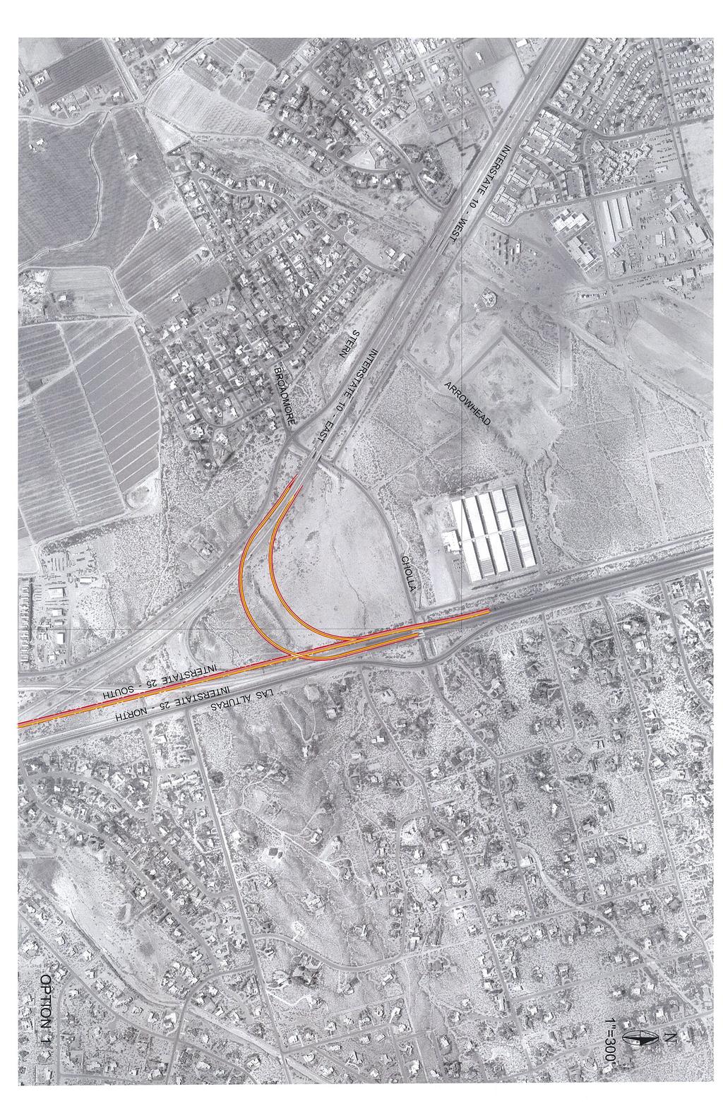
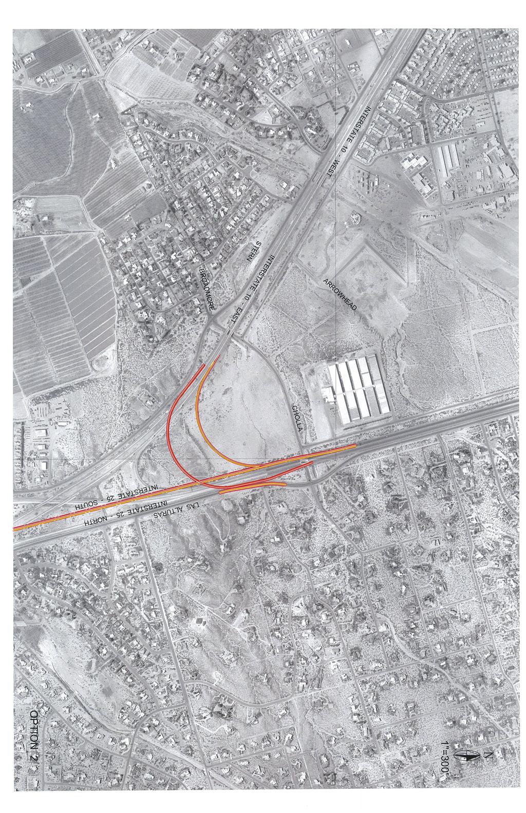
3 Interstate 40 Corridor Project: I-25 to Tramway Blvd Traffic Noise Analysis AC-GRIP-(IM-NH)-040-3(156)160; CN G1153 TABLE OF CONTENTS (CONTINUED) Tables Table 1 Noise Abatement Criteria...2 Table 2 Noise Measurement Results...4 Table 3 Noise Modeling Results Table 4 Summary of Noise Abatement Analysis Table 5 Elevations for Wall on West Side of I-10 in Las Cruces...15 Table 6 Elevations for Wall on West Side of I-10 in Anthony...15 Appendices Appendix A Approximate Noise Monitoring and Noise Modeling Locations Appendix B Options 1 & 2 for I-10/I-25 Interchange - ii -
4 Interstate 10: Las Cruces to Texas State Line Traffic Noise Analysis AC-GRIP-010-2(108)144; CN G18A1 1. Introduction This report documents the methodology and findings of a traffic noise analysis prepared for the New Mexico Department of Transportation s (NMDOT) Interstate 10 (I-10) Project. The I-10 project is evaluating transportation improvements along a 21 mile segment of I-10 between Las Cruces and the Texas State Line (milepost [MP] 143 to MP 164.2). The noise analysis was based on existing and future traffic data, mapping, and preliminary roadway design information developed in the Detailed Evaluation of Alternatives Report prepared for the I-10 project by Molzen-Corbin & Associates. The analysis was prepared according to Federal Highway Administration (FHWA) and NMDOT traffic noise policies and procedures. The I-10 project area begins at the I-10/I-25 interchange in Las Cruces and extends 21 miles to the southeast and terminates at the New Mexico/Texas State Line in Anthony, NM. Aside from the urbanized areas of Las Cruces and Anthony, most of the I-10 project area traverses undeveloped rangeland or agricultural land uses, with only scattered pockets of development. The focus of this noise analysis was to consider the noise effects of the project in developed areas with noise sensitive properties. Detailed analyses were conducted for the following areas: The I-10/I-25 Interchange Area, between stations and ; Between the Mesquite and Vado Interchanges, between stations and ; South of the Vado Interchange, between stations and ; The NM 404 Interchange area, and Anthony Area, between stations and In the I-10/I-25 interchange area in Las Cruces, I-10 has a posted speed of 65 miles per hour. In this area the freeway system network includes frontage roads and various ramp connections between I-25 and I-10 (see Figures A-1 through A-3 in Appendix A). In the rural portions of the study area, I-10 is a divided interstate highway with two travel lanes in each direction, two-way frontage roads and a posted speed limit of 70 miles per hour (see Figures A-4 through A-14). Proposed improvements to I-10 involve providing an additional through-lane in each direction of I-10 and reconfiguration of the I-10/I-25 interchange with various ramp improvements. Proposed geometric improvements for the I-10 project area are detailed in the Detailed Evaluation of Alternatives Report, prepared for the I-10 project by Molzen-Corbin & Associates. 2. FHWA/NMDOT Noise Policies and Procedures The relative loudness of a sound or noise is described in units of decibels (db), a measure of sound pressure on a logarithmic scale. For highway noise studies, traffic noise is averaged over the one-hour peak noise period and is expressed as an equivalent noise level (Leq). An A-weighting filter is also used to correlate physical noise levels with the frequency sensitivity of human hearing and the subjective response to noise. Thus, traffic noise conditions are generally discussed in terms of hourly average A-weighted noise levels in decibels, or Leq db(a). FHWA and NMDOT have adopted specific policies and procedures for evaluating traffic noise impacts and the need for noise abatement. According to FHWA and NMDOT procedures, noise abatement must be - 1 -
5 Interstate 10: Las Cruces to Texas State Line Traffic Noise Analysis AC-GRIP-010-2(108)144; CN G18A1 considered when predicted traffic noise levels approach or exceed specified noise abatement criteria (noise level thresholds) defined for various land use activity categories. NMDOT s noise policy defines approach as being within 1 decibel of the appropriate abatement criteria. Table 1 summarizes the noise abatement thresholds defined by FHWA and NMDOT s noise policies. Table 1 Noise Abatement Criteria (Hourly A-Weighted Noise Level in Decibels [dba]) Activity Category Leq(h) Description of Activity Category A 57 (Exterior) Lands on which serenity and quiet are of extraordinary significance and serve an important public need and where the preservation of those qualities is essential if the area is to continue to serve its intended purpose. B 67 (Exterior) Picnic areas, recreation areas, playgrounds, active sports areas, parks, residences, motels, hotels, schools, churches, libraries, and hospitals. C 72 (Exterior) Developed lands, properties, or activities not included in Category A or B above. D -- Undeveloped Lands E 52 (Interior) Residences, motels, hotels, public meeting rooms, schools, churches, libraries, hospitals, and auditoriums. Sources: 23 CFR 772; NM Transportation Commission Noise Abatement Policy (AD 236 and CP 86, 7/18/02) In addition to the noise abatement criteria, Federal and state procedures also require that noise abatement be considered when the implementation of a roadway project results in a substantial increase over existing noise levels. According to NMDOT s noise policy, an increase of 10 decibels or more is considered a substantial increase over existing noise levels. 3. Existing Conditions The highest concentration of development within the I-10 project area is located in the I-10/I-25 interchange area in Las Cruces (see Figures A-1 through A-3 in Appendix A). A residential neighborhood is located west of I-10 near Cholla Rd/Broadmoor Dr. This row of homes parallels the frontage road (Stern Dr) for approximately ½ mile, with the back yards located approximately 400 feet from the I-10 eastbound mainline traffic lanes. South of this area, a new residential subdivision is being developed (Dove Crossing). Several homes in this new subdivision are located immediately adjacent to the frontage road (Stern Dr). South of the Dove Crossing is a mobile home park (near Larjon Rd), with additional scattered residences to the south (near Grindell Rd). South of this area is a moderately large mobile home park that is situated immediately adjacent to Stern Dr (A Street, C Street, etc). On the east side of I-25 near Cholla Rd, and progressing southward toward Tellbrook Rd, is a low density residential area. Homes in this area east of the I-25 frontage road (Las Alturas Dr) are generally spaced approximately 200 feet apart. A more densely developed neighborhood is located between Tellbrook Rd and - 2 -
6 Interstate 10: Las Cruces to Texas State Line Traffic Noise Analysis AC-GRIP-010-2(108)144; CN G18A1 Las Piedras. In this area, homes vary in their distance from the I-25 frontage road (between 70 and 400 feet). South of Las Piedras is a small mobile home park. South of the I-10/I-25 interchange, the I-10 corridor is largely undeveloped, or has agricultural uses, and noise sensitive locations are present in only a few widely scattered locations. Between the Mesquite and Vado interchanges (Exits 151 and 155, respectively) several large dairy operations are located on the west side of I-10. Some pockets of residences are present near these dairy operations along the west frontage road (Stern Dr - see Figures A-6 and A-7 in Appendix A). Small pockets of homes are also located along Stern Dr on the west side of I-10 near Le Fe Ave and Swannack Dr in this area (see Figure A-8). South of NM 227 (Vado Rd), on the east side of I-10, a small RV park is present (See Figure A-8). South of this area, another dairy operation is located on the west side of I-10 with some residential structures adjacent to the west frontage. Most of the land area surrounding the NM 404 (Ohara Rd) interchange is undeveloped. However, a small pocket of homes is located east of the interchange, and one home is located on the west side of the interchange (see Figure A-12). At the southern end of the project area, the I-10 corridor enters Anthony, NM. This area is urbanized with a residential neighborhood on the west side of I-10 (see Figures A-13 and A-14). A large number of residences are present in this area, and these homes range from approximately 100 to 150 feet from the I-10 mainline traffic lanes. Existing noise conditions in the I-10 study area were evaluated by conducting field noise measurements using an Ono Sokki LA-1250 Integrating Sound Level Meter and a Larson Davis 820 Sound Level Meter. Noise measurements were conducted on November 13-14, 2006 at 16 sites considered to be representative of noise sensitive locations in the project area. Noise measurements were conducted during the AM and PM peak traffic periods (generally from 7:00 to 8:30 AM, and from 4:30 to 6:00 PM). The 16 noise monitoring sites are shown on the aerial photographs in Appendix A. Each noise measurement consisted of recording a 15-minute average noise level at each monitoring site. Table 2 summarizes the existing noise levels measured in the project area
7 Interstate 10: Las Cruces to Texas State Line Traffic Noise Analysis AC-GRIP-010-2(108)144; CN G18A1 Site # Site Description Table 2 Noise Measurement Results (Average A-Weighted Noise Levels in Decibels [Leq dba]) Figure # Appendix A Date Start Time End Time Measured Noise Level (Leq dba) I-10/I-25 Interchange Area 1 Residence - South of Agave Dr A-1 11/13/06 5:35 PM 5:50 PM Residence - North of Camino Real A-1 11/13/06 5:15 PM 5:30 PM Residence - South of Broadmoor Dr A-1 11/13/06 4:55 PM 5:10 PM Dove Crossing - South of Cholla A-1 11/13/06 4:45 PM 5:00 PM Residences - South of Cholla Rd A-1 11/13/06 5:28 PM 5:43 PM Mobile Homes - Larjon Rd A-2 11/13/06 5:05 PM 5:20 PM Residence - South of Winchester Rd A-2 11/13/06 5:10 PM 5:25 PM Mobile Homes - South of Las Piedras A-3 11/13/06 4:50 PM 5:05 PM Mobile Homes - C Street A-4 11/13/06 5:30 PM 5:45 PM Residences near Mountain View Dairy A-6 11/14/06 7:13 AM 7:28 AM Residences near Gonzales Dairy A-7 11/14/06 7:51 AM 8:06 AM Residences - Swannick Rd A-8 11/14/06 8:15 AM 8:30 AM Western Sky RV Park A-8 11/14/06 7:43 AM 7:58 AM Residences - NM 404 Interchange A-12 11/14/06 7:17 AM 7:36 AM Residences - North of Acosta Rd A-13 11/14/06 7:38 AM 7:53 AM Residences - North of Church St A-14 11/14/06 7:15 AM 7:30 AM 64.3 Shading indicates measured noise level approaches/exceeds FHWA/NMDOT Noise Abatement Criteria As shown in Table 2, measured noise levels ranged from approximately 59 to 70 decibels at the various measurement locations throughout the I-10 project area. Existing noise levels varied according to the distance between the monitoring sites and the I-10/I-25 travel lanes, and according to the amount of shielding provided by the surrounding terrain and nearby structures. As shown in Table 2, noise levels approaching or exceeding the 67 dba abatement criteria for Category B land uses were measured in some locations (3 of the 16 receptor locations evaluated). Existing noise impacts were identified at residential locations in close proximity near the I-10/I-25 frontage roads and freeway mainline in Las Cruces. However, noise levels near the 67 dba noise abatement criteria were also observed in many of the monitoring locations. In general, existing noise impacts potentially occur at residences and other noise sensitive properties that have a clear line of site to the freeway mainline and are located within approximately feet of the freeway mainline traffic lanes. Lower noise levels occur at more distant sites and at locations that have barriers (such as walls, building rows, cut-fill sections, etc.) shielding the line of site to the I-10 or I-25 mainline. The level of shielding varies considerably throughout the project area. 4. Impacts Noise impacts are identified when predicted noise levels approach or exceed 67 dba at noise sensitive locations (Category B receptors), or when the implementation of a roadway project results in a 10 decibel increase over existing noise levels. A noise modeling analysis was conducted to evaluate the potential for noise impacts to occur as a result of roadway geometric changes associated with the I-10 project and as a result of future traffic growth
8 Interstate 10: Las Cruces to Texas State Line Traffic Noise Analysis AC-GRIP-010-2(108)144; CN G18A1 FHWA s Traffic Noise Model (TNM Version 2.5) was used to evaluate existing (year 2006) and future (year 2030) noise conditions in the I-10 project area. TNM uses site-specific information including traffic volume and speed, vehicle classification data, roadway geometry, and site acoustical properties to predict peak-hour noise levels at selected noise receptor locations. The future roadway design and the existing and future peak hour traffic volumes were obtained from the Detailed Evaluation of Alternatives (Phase B) Report prepared for the project. The modeling analysis included the I-10 and I-25 mainline lanes, directional ramps associated with the I-10/I-25 interchange and the local frontage road system. Preliminary design plans were used as a basis for the modeling analysis. The Phase B report considered two options for the I-10 eastbound to I-25 northbound directional ramp at the I-10/I-25 interchange. Both of these options were considered as separate modeling scenarios. Graphics showing the two options for this directional ramp are provided in Appendix B. The modeling analysis assumed an average travel speed of 65 miles per hour for the I-10/I-25 mainline in Las Cruces, and a speed of 70 miles per hour was assumed for the portions of I- 10 south of Las Cruces. The noise analysis evaluated existing and future noise conditions at 53 receptor locations in the I-10 project area (see Appendix A). The existing year (2006) noise analysis utilized the existing roadway geometry and PM peak hour traffic volumes for I-10 and I-25. The future year (2030) noise analysis evaluated the ramp configurations recommended in the Phase B study prepared for the project, and the addition of a through lane in the eastbound and westbound directions of I-10 throughout the corridor. Table 3 summarizes the existing and future modeled noise levels for the I-10 study area for the 2030 Build condition. Table 3 Noise Modeling Results (Average A-Weighted Noise Levels in Decibels [Leq dba]) Project Segment Measured/Modeled Noise Levels (Leq dba) Site # Site Description Figure # Measured Existing 2030 Build Difference I-10/I-25 Interchange Area 1 Residence Vista Questa/Agave A Residence Vista Questa A Residence Vista Questa A Residence Vista Questa A Residence Vista Questa/Broadmoor A Residence Vista Questa/Broadmoor A Residence Karen Dr A Residence Karen Dr A Residence Karen Dr A Residence Dove Crossing A Residence Dove Crossing A Existing Residence A Residence East of I-25 A Residence East of I-25 A Residence East of I-25 A Continued Shading indicates 2030 noise level approaches/exceeds FHWA/NMDOT Noise Abatement Criteria - 5 -
9 Interstate 10: Las Cruces to Texas State Line Traffic Noise Analysis AC-GRIP-010-2(108)144; CN G18A1 Table 3 (Continued) Noise Modeling Results (Average A-Weighted Noise Levels in Decibels [Leq dba]) Project Segment Measured/Modeled Noise Levels (Leq dba) Site # Site Description Figure # Measured Existing 2030 Build Difference I-10/I-25 Interchange Area (continued) 16 Residence East of I-25 A Residence South of Tellbrook A Residence South of Tellbrook A Residence South of Tellbrook A Residence South of Tellbrook A Residence South of Tellbrook A Mobile Home Larjon A Mobile Home Larjon A Mobile Home Larjon A Mobile Home C St., F St., etc. A Mobile Home C St., F St., etc. A Mobile Home C St., F St., etc. A Mobile Home C St., F St., etc. A Mobile Home C St., F St., etc. A Mobile Home South of Las Piedras A Mobile Home South of Las Piedras A Between the Mesquite and Vado Interchanges 32 Dairy Residential Units Mtn View A Dairy Residential Units Gonzales A Residence La Fe Ave A Residence La Fe Ave A Residence Swannack Rd A South of Vado Interchange 37 Western Sky RV Park 1 st Row A Western Sky RV Park 2 nd Row A Mobile Homes - Dairy A NM 404 Interchange Area 40 Residence East A Residence East A Residence West A Anthony Area 43 Residence - North of Donaldson Ave A Residence - North of Donaldson Ave A Residence - North of Donaldson Ave A Residence - North of Donaldson Ave A Residence South of Donaldson Ave A Residence South of Donaldson Ave A Residence South of Donaldson Ave A Residence South of Donaldson Ave A Continued Shading indicates 2030 noise level approaches/exceeds FHWA/NMDOT Noise Abatement Criteria - 6 -
10 Interstate 10: Las Cruces to Texas State Line Traffic Noise Analysis AC-GRIP-010-2(108)144; CN G18A1 Table 3 (Continued) Noise Modeling Results (Average A-Weighted Noise Levels in Decibels [Leq dba]) Project Segment Measured/Modeled Noise Levels (Leq dba) Site # Site Description Figure # Measured Existing 2030 Build Difference Anthony Area (continued) 51 Residence South of Donaldson Ave A Residence South of Donaldson Ave A Residence South of Donaldson Ave A Shading indicates 2030 noise level approaches/exceeds FHWA/NMDOT Noise Abatement Criteria Two design options are being considered for the I-10/I-25 interchange area. These two options involve the ramp that routs eastbound I-10 traffic onto northbound I-25 (see Figures in Appendix B). The first option for this ramp (Option 1) directs eastbound traffic off of I-10 from the right side and merges into the left side of I-25 (Right/Left). The second option for this ramp (Option 2) directs eastbound traffic off of I-10 from the right side and merges into the right side of I-25 (Right/Right). Both of these options for the eastbound to northbound ramp resulted in nearly identical noise levels for the year 2030 Build condition. Modeled noise levels for the two ramp conditions differed by less than 0.5 in areas adjacent to I-10 and I-25. Based on these findings, the two ramp options are considered equivalent in their noise effects. As shown in Table 3, noise levels at most locations in the I-10 project area are to increase by 1 to 4 dba between the years 2006 and These increases are primarily the result of expected traffic growth on I- 10. The traffic data provided for use in the noise analysis indicates that traffic is expected to approximately double by the 2030 design year. A general principle of traffic noise is that noise levels will generally increase by approximately 3 decibels with a doubling of traffic. The results of the modeling analysis are consistent with this principal, since noise levels modeled at most locations in the project area are expected to increase by 3-4 decibels in the 2030 horizon year. In general, human hearing can perceive a difference of approximately 2-3 decibels in outdoor noise levels. Therefore, future noise levels will likely be perceived as being louder than existing noise levels at most locations in the project area. The expected increases in noise at all locations are below the 10 decibel increase used by NMDOT to define a substantial increase. Some effects in noise expected in the 2030 design year are attributed to geometric changes associated with the I-10 mainline and ramp modifications proposed for the I-10/I-25 interchange. Noise levels at some locations near the I-10/I-25 interchange will have minor changes in noise, or even reductions in noise, due to the proposed changes in ramp locations. These changes will shift traffic to other locations than where it is presently routed, and in some cases provide additional shielding from new fill sections. The modeled noise levels shown in Table 2 reflect the combined effects of geometric changes for the ramps and the addition of future traffic in the I-10/I-25 interchange area. As shown in Table 3, noise levels at many of the receptors located near the right-of-way are expected to experience future noise levels that approach or exceed FHWA and NMDOT noise abatement criteria for noise sensitive locations (i.e., higher than 66 dba for homes, schools, churches, etc). Future noise impacts are shown by shading in Table
11 Interstate 10: Las Cruces to Texas State Line Traffic Noise Analysis AC-GRIP-010-2(108)144; CN G18A1 5. Noise Abatement Analysis The noise monitoring study and the modeling analysis identified several locations where existing and future noise levels approach or exceed FHWA and NMDOT s noise abatement criteria. Therefore, noise abatement was considered for these locations. Noise abatement for highway projects usually involves the construction of noise barriers to shield impacted receptors from roadway noise sources. According to FHWA policies, noise abatement measures should be considered to provide substantial noise reductions at impacted locations. However, FHWA policies allow flexibility in determining appropriate noise abatement measures in the varying circumstances that can occur from different types of projects in varying locations. A fundamental principle of FHWA s policy is to evaluate noise abatement measures to ensure that their overall noise benefits are determined to outweigh the overall adverse social, economic, and environmental effects and the costs of the noise abatement measures. According to NMDOT s noise policy, noise abatement measures must be feasible and reasonable. Feasibility deals primarily with engineering considerations (e.g., if a barrier be built given the topography of the location, etc.). Reasonableness involves more subjective criteria, and implies that common sense and good judgment should be used to arrive at decisions pertaining to noise abatement. According to NMDOT s noise policy, several factors are used to evaluate the reasonableness of noise abatement, including: The Amount of Noise Reduction Provided. NMDOT requires that abatement measures provide at least a 5 dba reduction in noise. A noise reduction of 5 dba is generally observed as being noticeably less noisy. The Cost of Abatement. The maximum cost of abatement should not exceed $40,000 per benefited receptor (residence). A typical cost of $28.00 per square foot for noise wall materials and construction is used for estimating noise wall costs. Public Input. The views of affected residents shall be actively solicited and considered in determining the reasonableness and feasibility of noise abatement measures. Noise abatement is generally not provided for commercial land uses (Category C receptors). Noise abatement primarily involves measures to reduce outdoor noise levels at ground level locations, and it is not considered reasonable to evaluate second floor (or higher) locations for noise abatement. Noise walls are generally limited to a maximum height of 20 feet. Isolated Receptors. It is not considered reasonable to provide noise abatement for isolated receptors (i.e., one or two residences set apart from other residences). The intent of the NMDOT noise policy is to provide mitigation for communities and neighborhoods. Typically, groups of three or more homes are considered for noise abatement. In general, the noise abatement analysis reviewed the feasibility and reasonableness of constructing noise walls in areas where traffic noise impacts were identified in the I-10 project area. The approximate locations of the evaluated noise walls are provided in Appendix A. The analysis generally considered the following elements: 1) if a noise wall could be reasonably constructed in a given area, 2) if the noise wall would provide a minimum 5 dba reduction in noise, and 3) if the wall can be constructed for less than $40,000 per benefited receptor. A typical cost of $28.00 per square foot for noise wall materials and construction was used to estimate the cost for the noise walls that were considered. The TNM noise model was used to - 8 -
12 Interstate 10: Las Cruces to Texas State Line Traffic Noise Analysis AC-GRIP-010-2(108)144; CN G18A1 evaluate the effectiveness of noise walls that could be constructed, and to verify that at least a 5 dba reduction in noise would occur. The findings and recommendations of the abatement analysis are considered preliminary. As noted above, an important element of the abatement analysis will be to solicit input from affected property owners. 5.1 I-10/I-25 Interchange Area The noise abatement analysis evaluated the cost-effectiveness of noise walls at several locations in the I- 10/I-25 interchange area, including a neighborhood on the west side of I-10 near Cholla Rd/Broadmoor Dr, a neighborhood on the east side of I-25 and south of Tellbrook Rd, and at three mobile home parks. The following sections discuss the noise abatement analyses conducted for these locations West of I-10 Near Cholla Rd/Broadmoor Dr Noise abatement was evaluated for the neighborhood west of I-10 near Cholla Rd/Broadmoor Dr (see Figure A-1, receptors 1 through 12). The noise wall considered for this area involved evaluating a barrier at the outside edge of the I-10 mainline. The frontage road (Stern Dr) in this area also contributes substantially to noise in this area; however because the frontage road is situated below the elevation of I-10, a rather tall wall would be needed to break the line of site between the homes and the freeway, and would not be practical. A 12 foot tall noise wall was evaluated adjacent to the I-10 mainline for the area west of Cholla Rd (2,700 feet in length). The area east of Cholla Rd is currently being developed (Dove Crossing), and the noise wall was extended southward to consider several receptors in this new residential development. A 14 foot tall noise was evaluated for the area east of Cholla Rd (1,700 feet in length). The results of the barrier analysis for this area are shown in Table 4. The barrier analysis indicates that this barrier design (4,400 feet long and feet tall) would provide the minimum 5 dba reduction in noise at some, but not at all, locations. In general, a 5 dba reduction in noise would be difficult to achieve at front row homes located near the frontage road due to noise from the frontage. For the analysis it was assumed the noise wall would provide a 5 dba noise reduction for as many as 30 homes to the north and south of Cholla Rd/Broadmoor Dr. The noise wall would cost approximately $1,573,600 for an average cost of $52,450 per receptor. Because this cost exceeds NMDOT s maximum cost per receptor ($40,000), this wall is not recommended for the I-10 project East of I-25 Near Cholla Rd A noise wall was evaluated for a low density neighborhood east of I-25 near Cholla Rd (see Figure A-1, receptors 13 through 16). The noise abatement considered for this area involved evaluating a barrier at the outside edge of the I-25 mainline. Initially, a 12 foot tall noise wall (3,440 feet long) was evaluated adjacent to this neighborhood. The results of the barrier analysis for this area are shown in Table 4. The barrier analysis indicates that a 12 foot tall noise wall would provide a 3-6 dba reduction for approximately 7 homes. Because these homes are widely spaced, the cost for providing noise abatement for the entire neighborhood would be prohibitive. The noise wall considered in this preliminary analysis would cost approximately $1,152,480 for an average cost of $164,640 per receptor. Because this cost exceeds NMDOT s maximum cost per receptor ($40,000), this wall is not recommended for the I-10 project East of I-25 South of Tellbrook Rd Noise abatement was evaluated for a residential neighborhood east of I-25 and south of Tellbrook Rd (see Figure A-2, receptors 17 through 21). The noise abatement considered for this area involved evaluating a - 9 -
13 Interstate 10: Las Cruces to Texas State Line Traffic Noise Analysis AC-GRIP-010-2(108)144; CN G18A1 noise wall at the eastern shoulder of the westbound I-10 to northbound I-25 directional ramp. A noise wall at the eastern edge of the frontage road (Los Alturas Dr) in this area would be problematic due to the access requirements at Tellbrook Rd, Colt Rd and Winchester Rd. Several wall heights were evaluated for this location. Results of the barrier analysis are shown in Table 4. A wall height of 18 feet along the eastern edge of the westbound to northbound ramp would result in a marginally effective noise reduction of 4 to 6 decibels at homes in this area. The limited effectiveness of a noise wall in this area is attributed to additional noise from frontage road traffic on Los Alturas Dr, and from noise on the I-25 southbound to I-10 westbound directional ramp, which will be realigned and elevated above the noise wall. Based on a wall height of 18 feet, the evaluated noise wall (2,520 feet long) would cost approximately $1,270,080 for an average cost of $127,000 per receptor (based on 10 homes in this area). Because this cost exceeds NMDOT s maximum cost per receptor ($40,000), this wall is not recommended for the I-10 project Mobile Home Park Larjon Rd Noise abatement was evaluated for a mobile home park located west of I-10 at Larjon Rd (see Figure A-2, receptors 22 through 24). The noise wall considered for this area involved a barrier at the western shoulder of the I-10 mainline, since a continuous noise wall on the west frontage (Stern Dr) would prohibit access to the mobile home park and other adjacent properties. A combination of walls was evaluated for this location, including a 14 foot tall wall at the I-10 eastbound mainline and a 10 foot tall wall at the I-25 southbound to I-10 eastbound directional ramp. A summary of the barrier analysis results are shown in Table 4. This wall would only provide limited noise reduction benefits (1-3 dba) at the mobile home park due to noise from the west frontage road. This wall configuration would have a total length of 1,600 feet and cost approximately $562,860. This wall configuration would not provide any meaningful noise reduction at the mobile home park and is not recommended for the I-10 project Mobile Home Park C St., F St., etc Noise abatement was evaluated for a mobile home park located on the west side I-10 and south of Las Piedras Street (see Figure A-3, receptors 25 through 29). The noise wall considered for this area involved a barrier at the western shoulder of the west frontage road (Stern Dr). No access is provided along the frontage road in this area and a continuous noise wall is feasible adjacent to the property. A 10 foot tall wall with a length of 1,600 feet was evaluated. As shown in Table 4, this wall would reduce noise levels at the first row of mobile homes (14 units) by 5 dba or more. However, a lower noise reduction would be achieved at the southernmost property boundary, due to the wall s termination at A Street. This wall would cost approximately $448,000 for an average cost per receptor of $32,000. Because this wall achieves a 5 dba reduction at most mobile homes, and costs less than $40,000 per receptor, this wall is recommended for the I-10 project Mobile Home Park Las Piedras St Noise abatement was evaluated for a mobile home park and a small apartment building is located east of I- 10 and south of Las Piedras Street (see Figure A-3, receptors 30 and 31). The noise wall considered for this area involved a barrier at the western shoulder of the east frontage road (Los Alturas Dr), since a continuous noise wall on the east side of the frontage road would prohibit access to the mobile home park and other adjacent properties. A 16 foot tall wall with a length of 900 feet was evaluated. As shown in Table 4, this wall would reduce noise levels at the first two rows of mobile homes (4 units) and at 4 individual apartment units by 5 dba. However, lower noise reductions would be achieved at setback mobile homes. This wall
14 Interstate 10: Las Cruces to Texas State Line Traffic Noise Analysis AC-GRIP-010-2(108)144; CN G18A1 would cost approximately $403,200 for an average cost per receptor of $50,400. Because this cost exceeds NMDOT s maximum cost per receptor ($40,000), this wall is not recommended for the I-10 project. 5.2 Between Mesquite and Vado Interchanges West of I-10 Near Mountain View Dairy Two small pockets of homes and mobile homes occurs along the west side of I-10 south of the Mesquite interchange (see Figure A-6, receptor 32). The noise wall considered for this area was at the outside edge of the I-10 mainline. The frontage road (Stern Dr) in this area also contributes to noise in this area; however, a noise wall is not feasible on the west side of the frontage road because it would block access to the adjacent properties. A 12 foot tall wall with a length of 2,300 feet was evaluated adjacent to the I-10 mainline. As shown in Table 4, this wall would reduce noise levels at the first row of homes (11 units) by 5 dba or more. This wall would cost approximately $772,800 for an average cost per receptor of $70,250. Because this cost exceeds NMDOT s maximum cost per receptor ($40,000), this wall is not recommended for the I-10 project West of I-10 Near Gonzales Family Dairy A small pocket of homes and mobile homes occurs along the west side of I-10 near the Gonzales Family Dairy (see Figure A-7, receptor 33). The noise wall considered for this area was at the outside edge of the I- 10 mainline. The frontage road (Stern Dr) in this area also contributes to noise in this area; however, a noise wall is not feasible on the west side of the frontage road because it would block access to the adjacent properties. A 12 foot tall wall with a length of 950 feet was evaluated adjacent to the I-10 mainline. As shown in Table 4, this wall would reduce noise levels at the first row of homes (5 units) by 5 dba or more. This wall would cost approximately $319,200 for an average cost per receptor of $63,840. Because this cost exceeds NMDOT s maximum cost per receptor ($40,000), this wall is not recommended for the I-10 project West of I-10 Near Le Fe Ave A small pocket of homes and mobile homes occurs along the west side of I-10 near Le Fe Avenue (see Figure A-7, receptors 34 and 35). The noise wall considered for this area involved evaluating a barrier at the outside edge of the I-10 mainline. The frontage road (Stern Dr) in this area also contributes to noise in this area; however, a noise wall is not feasible on the west side of the frontage road because it would block access to Le Fe Avenue. A 12 foot tall wall with a length of 700 feet was evaluated adjacent to the I-10 mainline. As shown in Table 4, this wall would reduce noise levels at the first row of homes (4 units) by 5 dba or more. This wall would cost approximately $235,200 for an average cost per receptor of $58,800. Because this cost exceeds NMDOT s maximum cost per receptor ($40,000), this wall is not recommended for the I-10 project West of I-10 Near Swannack Rd A small pocket of homes and mobile homes occurs along the west side of I-10 near Swannack Rd (see Figure A-8, receptor 36 and 12). The noise wall considered for this area involved evaluating a barrier at the outside edge of the I-10 mainline. The frontage road (Stern Dr) in this area also contributes to noise in this area; however, a noise wall is not feasible on the west side of the frontage road because it would block access to Swannack Rd. A 12 foot tall wall with a length of 600 feet was evaluated adjacent to the I-10 mainline. As shown in Table 4, this wall would reduce noise levels at the first row of homes (2 units) by
15 Interstate 10: Las Cruces to Texas State Line Traffic Noise Analysis AC-GRIP-010-2(108)144; CN G18A1 dba or more. This wall would cost approximately $201,600 for an average cost per receptor of $100,800. Because this cost exceeds NMDOT s maximum cost per receptor ($40,000), this wall is not recommended for the I-10 project. 5.3 South of Vado Interchange Western Sky RV Park The Western Sky RV Park is located on the east side of I-10 and south of the Vado interchange (see Figure A-8, receptors 37 and 38). The noise wall considered for this area involved evaluating a barrier at the outside edge of the I-10 mainline. A 12 foot tall wall with a length of 700 feet was evaluated adjacent to the I-10 mainline. As shown in Table 4, this wall would reduce noise levels at the first row of RVs (5 units) by 5 dba or more. This wall would cost approximately $235,200 for an average cost per receptor of $47,040. Because this cost exceeds NMDOT s maximum cost per receptor ($40,000), this wall is not recommended for the I-10 project West Side of I-10 Near Dairy A small pocket of homes and mobile homes occurs along the west side of I-10 near a dairy operation (see Figure A-9, receptor 39). The noise wall considered for this area involved evaluating a barrier at the outside edge of the I-10 mainline. The frontage road (Stern Dr) in this area also contributes to noise in this area; however, a noise wall is not feasible on the west side of the frontage road because it would block access to the adjacent properties. A 12 foot tall wall with a length of 1,200 feet was evaluated adjacent to the I-10 mainline. As shown in Table 4, this wall would reduce noise levels at the first row of residences (7 units) by 5 dba or more. This wall would cost approximately $403,200 for an average cost per receptor of $57,600. Because this cost exceeds NMDOT s maximum cost per receptor ($40,000), this wall is not recommended for the I-10 project. 5.4 Anthony Area Noise abatement was evaluated for a large neighborhood on the west side of I-10 in Anthony (see Figures A-13 and A-14, and receptors 43 through 53). For this large neighborhood the noise wall was evaluated to be constructed in three overlapping sections, as follows: Section 1. This barrier section would be constructed at the edge of the eastbound I-10 mainline, between stations and This 1,400 foot long wall would be 10 feet tall. Section 2. This barrier section would be constructed in the higher terrain adjacent to the frontage road (Sandia Street), between stations and This 1,000 foot long noise wall would be 8 feet tall. Section3. This barrier section would be constructed at the edge of the eastbound I-10 mainline, between stations and The southern edge of this barrier would follow the alignment of the eastbound off-ramp for approximately 250 feet toward Antonio Street. This 1,900 foot long noise wall would be 10 feet tall. The results of the barrier analysis for this area are shown in Table 4. The wall configuration described above would cost approximately $1,148,000. The wall design would provide a meaningful noise reduction of 5 dba or more at approximately 30 homes, for an average cost of $38,300 per receptor. This wall would meet NMDOT s cost-effectiveness requirements and is recommended for the I-10 project
16 Interstate 10: Las Cruces to Texas State Line Traffic Noise Analysis AC-GRIP-010-2(108)144; CN G18A1 Table 4 Summary of Noise Abatement Analysis Noise Wall Location Site # Figure # Year 2030 Build Modeled Noise Levels With Wall Noise Reduction West of I-10 Near Cholla Rd/Broadmoor Dr 1 A A A A A A A A A A A A East of I-25 Near Cholla Rd 13 A A A A East of I-25 South of Tellbrook Rd 17 A A A A A Mobile Home Park at Larjon Rd 22 A A A Mobile Home Park -C St., F St., etc. 25 A A A A A Mobile Home/Apartments South of Las Piedras 30 A A Wall Length (ft) Wall Height (ft) Wall Cost Cost per Receptor 4, $1,573,200 $52,450 3, $1,152,480 $164,640 2, $1,270,080 $127,000 1, $562,856 n.a. Noise Wall Recommended/ Warranted? Not Recommended Not Recommended Not Recommended Not Recommended 1, $448,000 $32,000 Recommended $403,200 $50,400 Not Recommended Continued
17 Interstate 10: Las Cruces to Texas State Line Traffic Noise Analysis AC-GRIP-010-2(108)144; CN G18A1 Noise Wall Location Site # Figure # Year 2030 Build Table 4 (Continued) Summary of Noise Abatement Analysis Modeled Noise Levels With Wall Noise Reduction Mobile Homes/Residences Between Mesquite and Vado Interchanges Wall Length (ft) Wall Height (ft) Wall Cost Cost per Receptor 32 A , $772,800 $70, A $319,200 $63, A A $235,200 $58, A $201,600 $100,800 South of Vado Interchange 37 A A $235,200 $47, A , ,200 $57,600 West Side of I-10 in Anthony 43 A A A A A A A A A A A Noise Wall Recommended/ Warranted? Not Recommended Not Recommended Not Recommended Not Recommended Not Recommended Not Recommended 4, $1,148,000 $38,300 Recommended Tables 5 and 6 summarize the approximate locations and elevations of the two noise walls meeting NMDOT s cost-effectiveness criteria in the I-10 project area
18 Interstate 10: Las Cruces to Texas State Line Traffic Noise Analysis AC-GRIP-010-2(108)144; CN G18A1 Approx. Station* Table 5 Elevations for Wall on West Side of I-10 in Southern Las Cruces (Mobile Home Park: Receptors 25-29, C St., F St., etc.) Ground Elevation (f) Top of Wall Elevation (f) Wall Height (f) Notes ,962 3, Follow Stern Dr Alignment ,965 3, ,967 3, ,969 3, ,970 3, ,970 3, Terminate at A Street * Stations Refer to I-25 Southbound to I-10 Eastbound Directional Ramp/Ground Elevations Refer to Stern Dr. Approx. Station* Section 1 Ground Elevation (f) Table 6 Elevations for Wall on West Side of I-10 in Anthony (Receptors 43-53) Top of Wall Elevation (f) Wall Height (f) ,912 3, Follow Edge of I-10 Mainline ,914 3, ,914 3, ,914 3, Section ,918 3,926 8 Follow Top Ground Elevations ,922 3,930 8 Between I-10 and Frontage Road (Sandia St.) ,928 3, ,930 3, ,930 3, ,924 3, ,918 3, ,914 3,922 8 Section ,912 3, Follow Edge of I-10 Mainline ,910 3, ,910 3, Follow Eastbound off Ramp Alignment ,908 3, Follow Eastbound off Ramp Alignment * Stations Refer to I-10 Eastbound Mainline Ground Elevations Refer to I-10 Mainline Elevations for Sections 1 and 3 Ground Elevations Refer to Existing Grade Between I-10 and Frontage Road for Section 2 Notes
19 Interstate 10: Las Cruces to Texas State Line Traffic Noise Analysis AC-GRIP-010-2(108)144; CN G18A1 The final locations and construction heights of noise walls in the I-10 project area should be determined after public input has been obtained. In addition, because the abatement analysis was conducted with preliminary design plans, and because some of the noise walls are located in complex topography, refinements to the barrier analyses should be conducted during the final design phases of the project. Final placement and height of noise walls will be determined as part of final design activities and with input from affected property owners. Additional features of the noise walls, such as aesthetic design, will also be determined during final design for the I-10 project. The findings of this noise analysis represent the most recent evaluation of noise conditions within the I-10 project area. One purpose of this analysis is to provide local governments with information regarding the existing and future noise conditions expected within the I-10 project area. FHWA and NMDOT noise policies strongly advocate the prevention of future noise impacts as being one of the most important aspects of noise control. Both development and highways can be compatible. But local government officials should be aware of what noise levels to expect from highways and what techniques they can use to prevent future impacts. FHWA encourages local governments to practice compatible land use planning and control in the vicinity of highways. Local governments should use their power to regulate land development in such a way that noise-sensitive land uses are either prohibited from being located adjacent to a highway, or that the developments are planned, designed, and constructed in a manner that ensures noise impacts are minimized. According to NMDOT s Noise Policy (CP 86 & AD 236), Noise abatement measures will be considered for new development that occurs before the date of public knowledge of the adoption of the location of a proposed highway project. After this date analysis of changes in traffic noise impacts, when appropriate, may be done, but the Department will no longer be responsible for providing noise abatement for new development which occurs adjacent to the proposed highway project. Provision of such noise abatement becomes the responsibility of local communities and private developers. The date of public knowledge referred to in NMDOT s Noise Policy is the date of approval of the environmental document. For the current I-10 project, this date will coincide with the approval of the anticipated Finding of No Significant Impact (FONSI) for the project. After this date, NMDOT will not be responsible for, and FHWA will not provide funding for, additional noise abatement in the I-10 project area
20 Appendix A Noise Monitoring and Noise Modeling Locations

21 13 14 Evaluated Noise Wall (Not Recommended) Evaluated Noise Wall (Not Recommended) Dove Crossing Development 17 N No Scale Figure A-1 Approximate Noise Measurement and Modeling Locations 5 Noise Measurement Site 5 Noise Modeling Site

22 Dove Crossing Development 12 Evaluated Noise Wall (Not Recommended) 17 Evaluated Noise Wall (Not Recommended) N No Scale Figure A-2 Approximate Noise Measurement and Modeling Locations 5 Noise Measurement Site 5 Noise Modeling Site

23 Evaluated Noise Wall (Not Recommended) Evaluated Noise Wall (Recommended) N No Scale Figure A-3 Approximate Noise Measurement and Modeling Locations 5 Noise Measurement Site 5 Noise Modeling Site

24 N No Scale Figure A-4 Approximate Noise Measurement and Modeling Locations 5 Noise Measurement Site 5 Noise Modeling Site

25 N No Scale Figure A-5 Approximate Noise Measurement and Modeling Locations 5 Noise Measurement Site 5 Noise Modeling Site

26 Evaluated Noise Wall (Not Recommended) N No Scale Figure A-6 Approximate Noise Measurement and Modeling Locations 5 Noise Measurement Site 5 Noise Modeling Site

27 33 Evaluated Noise Wall (Not Recommended) 11 La Fe Ave35 La Fe Ave 34 Evaluated Noise Wall (Not Recommended) N No Scale Figure A-7 Approximate Noise Measurement and Modeling Locations 5 Noise Measurement Site 5 Noise Modeling Site

28 Swannack Rd Evaluated Noise Wall (Not Recommended) Evaluated Noise Wall (Not Recommended) N No Scale Figure A-8 Approximate Noise Measurement and Modeling Locations 5 Noise Measurement Site 5 Noise Modeling Site

29 Evaluated Noise Wall (Not Recommended) N No Scale Figure A-9 Approximate Noise Measurement and Modeling Locations 5 Noise Measurement Site 5 Noise Modeling Site

30 N No Scale Figure A-10 Approximate Noise Measurement and Modeling Locations 5 Noise Measurement Site 5 Noise Modeling Site

31 N No Scale Figure A-11 Approximate Noise Measurement and Modeling Locations 5 Noise Measurement Site 5 Noise Modeling Site

32 N No Scale Figure A-12 Approximate Noise Measurement and Modeling Locations 5 Noise Measurement Site 5 Noise Modeling Site
 N No Scale Figure A-13 Approximate Noise Measurement and Modeling Locations 5 Noise Measurement Site 5 Noise")
33 Section 1 Noise Wall (Recommended) Section 2 Noise Wall (Recommended) 49 Section 3 Noise Wall (Recommended) N No Scale Figure A-13 Approximate Noise Measurement and Modeling Locations 5 Noise Measurement Site 5 Noise Modeling Site

34 48 Section 2 Noise Wall (Recommended) Section 3 Noise Wall (Recommended) 53 N No Scale Figure A-14 Approximate Noise Measurement and Modeling Locations 5 Noise Measurement Site 5 Noise Modeling Site
35 Appendix B Options 1 & 2 for I-10/I-25 Interchange
36
37
APPENDIX C NOISE STUDY TECHNICAL REPORT
 APPENDIX C NOISE STUDY TECHNICAL REPORT Noise Study Technical Report Watertown South Connector US 81 to 29 th Street SE Watertown, South Dakota HDR Project No. 39319 Prepared by 6300 So. Old Village Place
MnDOT GREATER MN STAND ALONE NOISE BARRIER PROGRAM
 MnDOT GREATER MN STAND ALONE NOISE BARRIER PROGRAM 7 November 2017 MINNESOTA S EXPERIENCE WITH HIGHWAY NOISE MITIGATION The Minnesota Department of Transportation (MnDOT) has been constructing noise walls
APPENDIX C NOISE STUDY TECHNICAL REPORT
 APPENDIX C NOISE STUDY TECHNICAL REPORT 1) 9/25/06 Noise Study Technical Report; revised 05/08 2) 9/4/09 Memo Regarding Option 3 Noise Impacts to Pelican Lake Game Production Area Noise Study Technical
1. Introduction Noise Analysis Results Figures. List of Tables
 Traffic Noise Technical Report FM 2218 Widening (From US 59 to SH 36) Fort Bend County Prepared by: Houston District Date: July 2017 CSJ: 2093-01-010 The environmental review, consultation, and other actions
FEDERAL BOULEVARD (5 TH AVENUE TO HOWARD PLACE) PLANNING ENVIRONMENTAL LINKAGE STUDY TRAFFIC NOISE IMPACT ANALYSIS
 PLANNING ENVIRONMENTAL LINKAGE STUDY TRAFFIC NOISE IMPACT ANALYSIS") FEDERAL BOULEVARD (5 TH AVENUE TO HOWARD PLACE) PLANNING ENVIRONMENTAL LINKAGE STUDY TRAFFIC NOISE IMPACT ANALYSIS Prepared for: City and County of Denver 201 West Colfax Avenue, Department 509 Denver,
FEDERAL BOULEVARD (5 TH AVENUE TO HOWARD PLACE) PLANNING ENVIRONMENTAL LINKAGE STUDY TRAFFIC NOISE IMPACT ANALYSIS Prepared for: City and County of Denver 201 West Colfax Avenue, Department 509 Denver,
COMPONENTS OF THE NOISE ELEMENT
 COMPONENTS OF THE NOISE ELEMENT Definitions Following is a list of commonly used terms and abbreviations that may be found within this element or when discussing the topic of noise. This is an abbreviated
Peak noise levels during any time period can be characterized with statistical terms.
 3.11 NOISE Introduction This Noise section provides a discussion of applicable noise policies and standards, the results of ambient noise measurements, an evaluation of the projects compatibility with
Virginia Department Of Transportation. Highway Traffic Noise Impact Analysis Guidance Manual
 Virginia Department Of Transportation Highway Traffic Noise Impact Analysis Guidance Manual FHWA Approval: March 15, 2011 CTB Approval: June 15, 2011 Effective: July 13, 2011 Last Updated: February 20,
Draft Noise Study Report
 Florida Department of TRANSPORTATION PD&E Study From East of Babcock Street (SR 507) to US 1 Brevard County, Florida FPID: 430136 1 22 01 ETDM: 13026 The environmental review, consultation, and other actions
Traffic Noise Introduction to Traffic Noise Analysis and Abatement
 Traffic Noise Introduction to Traffic Noise Analysis and Abatement NW Bethany Blvd Improvement Project Michael Minor, President Michael Minor & Associates Inc. Introduction to Acoustics What is Noise?
US 53 Noise Mitigation
 US 53 Noise Mitigation 1 Meeting Agenda Introductions Brief Project Overview Terminology Agencies Involved Rules/Regulations Noise Characteristics Project Approach Mitigation Possible Noise Mitigation
FIGURE N-1 LAND USE COMPATIBILITY FOR NEW DEVELOPMENT NEAR TRANSPORTATION NOISE SOURCES
 NOISE ELEMENT OBJECTIVES AND POLICIES Noise Standards N1. To protect the citizens of Arroyo Grande from the harmful and annoying effects of exposure to excessive noise. Policy N1-1 The noise standards
NOISE STUDY REPORT DESIGN ADDENDUM
 NOISE STUDY REPORT DESIGN ADDENDUM for Wekiva Parkway Segment 8 - Ballantrae Apartments Seminole County, Florida Financial Project ID: 240200-4-32-01 Prepared for: Florida Department of Transportation
Virginia Department of Transportation I-66 Tier 2 Environmental Assessment
 Virginia Department of Transportation I-66 Tier 2 Environmental Assessment VDOT Project 0066-96A-297, UPC #105500 Prince William and Fairfax County, Virginia PRELIMINARY NOISE ANALYSIS Submitted to: Virginia
BAY MEADOWS PHASE II SPAR 2 SAN MATEO, CALIFORNIA
 Charles M Salter Associates Inc BAY MEADOWS PHASE II SPAR 2 SAN MATEO, CALIFORNIA RESIDENTIAL INTERIOR NOISE ANALYSIS Prepared for: Kim Havens Wilson Meany Sullivan Four Embarcadero Center, Suite 3330
Noise Analysis Study along I Tim Bjorneberg Project Development Program Manager SDDOT
 Noise Analysis Study along I - 29 Tim Bjorneberg Project Development Program Manager SDDOT Meeting Format Very informal Meeting is not recorded General questions after presentations Specific questions
APPENDIX A TIER 1 ANALYSIS
 SPN H.004100 FEASIBILITY STUDY APPENDIX A TIER 1 ANALYSIS 040-012-042AH Appendices Lead Sheets PROVIDENCE STATE PROJECT. H.004100 The following worksheets analyze various project alternatives at various
South Access to the Golden Gate Bridge Doyle Drive Project EXECUTIVE SUMMARY
 EXECUTIVE SUMMARY This addendum to the December 2004 Final Noise and Vibration Study (NVS) presents the results of the noise impact assessment of two new and previously unstudied design options associated
12-1 INTRODUCTION 12-2 REGULATORY REQUIREMENTS
 Chapter 12: Noise and Vibration 12-1 INTRODUCTION This chapter assesses the potential noise and vibration effects resulting from operation of the Tappan Zee Hudson River Crossing Project. The potential
APPENDIX B. Public Works and Development Engineering Services Division Guidelines for Traffic Impact Studies
 APPENDIX B Public Works and Development Engineering Services Division Guidelines for Traffic Impact Studies Revised December 7, 2010 via Resolution # 100991 Reformatted March 18, 2011 TABLE OF CONTENTS
Appendix K. Environmental Noise Assessment
 Appendix K Environmental Noise Assessment ENVIRONMENTAL NOISE ASSESSMENT THORNTON ROAD NORTH TAUNTON ROAD WEST TO WINCHESTER ROAD WEST SCEDULE 'C' MUNICIPAL CLASS ENVIRONMENTAL ASSESSMENT CITY OF OSHAWA
Appendix D: Functional Classification Criteria and Characteristics, and MnDOT Access Guidance
 APPENDICES Appendix D: Functional Classification Criteria and Characteristics, and MnDOT Access Guidance D.1 Functional classification identifies the role a highway or street plays in the transportation
I-10 CORRIDOR IMPROVEMENTS STAGE 0 FEASIBILITY STUDY STATE PROJECT NUMBER H FEDERAL AID PROJECT NUMBER H004100
 JULY 2016 I-10 CORRIDOR IMPROVEMENTS STAGE 0 FEASIBILITY STUDY STATE PROJECT NUMBER H.004100 FEDERAL AID PROJECT NUMBER H004100 EAST BATON ROUGE AND WEST BATON ROUGE PARISHES, LOUISIANA Section TABLE OF
GEOMETRIC DESIGN CRITERIA for Non-freeway Resurfacing, Restoration, and Rehabilitation Projects
 GEOMETRIC DESIGN CRITERIA for Non-freeway Resurfacing, Restoration, and Rehabilitation Projects SEPTEMBER 1989 Arkansas State Highway and Transportation Department GEOMETRIC DESIGN CRITERIA for Non-freeway
Appendix B Highway 407 Interchange Review - Cochrane Street Area
 Appendix B Highway 407 Interchange Review - Cochrane Street Area AECOM 300 ater Street hitby, ON, Canada L1N 9J2 www.aecom.com Memorandum To Michael May, P.Eng., Town of hitby Page 1 CC Subject Greg Hardy,
LAS VEGAS STREET RAILROAD CROSSING RR/PUC CONNECTION AND PRELIMINARY DESIGN
 LAS VEGAS STREET RAILROAD CROSSING RR/PUC CONNECTION AND PRELIMINARY DESIGN Prepared for: City of Colorado Springs Prepared by: Felsburg Holt & Ullevig 508 South Tejon Street Colorado Springs, CO 80903
LOCATION AND DESIGN DIVISION
 VIRGINIA DEPARTMENT OF TRANSPORTATION LOCATION AND DESIGN DIVISION INSTRUCTIONAL AND INFORMATIONAL MEMORANDUM GENERAL SUBJECT: Interstate, NHS Non-Interstate and Non-NHS (IJR / IMR Guidance) SPECIFIC SUBJECT:
Highway Traffic Noise: Analysis and Abatement Guidance
 Highway Traffic Noise: Analysis and Abatement Guidance 1 TABLE OF CONTENTS TABLE OF CONTENTS... 2 THREE-PART APPROACH TO HIGHWAY TRAFFIC NOISE ABATEMENT... 6 Noise Compatible Planning... 6 Source Control...
Interchange Workshop Report (August 2004)
") U.S. Highway 14 Corridor Study New Ulm to North Mankato Table of Contents Section Interchange Workshop Report (August 2004) Page 1. Introduction and Next Steps 1 2. Interchange Workshop Participants &
U.S. Highway 14 Corridor Study New Ulm to North Mankato Table of Contents Section Interchange Workshop Report (August 2004) Page 1. Introduction and Next Steps 1 2. Interchange Workshop Participants &
Woodburn Interchange Project Transportation Technical Report
 Final Report Woodburn Interchange Project Transportation Technical Report Prepared for Oregon Department of Transportation April 212 Prepared by DKS Associates Contents Methodologies... 4 Volume Development...
Jim Alexander Director of Design and Engineering, Southwest Light Rail Transit Project
 Memorandum Date: January 15, 2014 To: CC: From: Subject: Jim Alexander Director of Design and Engineering, Southwest Light Rail Transit Project Paul Danielson, P.E. Project Manager, Southwest Light Rail
2 Purpose and Need. 2.1 Study Area. I-81 Corridor Improvement Study Tier 1 Draft Environmental Impact Statement
 2 Purpose and Need 2.1 Study Area Interstate 81 (I-81) is relied upon for local and regional travel and interstate travel in the eastern United States. It extends 855 miles from Tennessee to New York at
ENVIRONMENTAL NOISE ASSESSMENT
 ENVIRONMENTAL NOISE ASSESSMENT LAKEVIEW BOULEVARD ENVIRONMENTAL ASSESSMENT LAKEVIEW BOULEVARD BETWEEN POPLAR AVENUE AND MAPLE AVENUE TOWN OF AJAX PREPARED FOR: TMIG February 2017 Y1610 TABLE OF CONTENTS
Noise Study Bristol Park Redevelopment Area
 Noise Study Bristol Park Redevelopment Area Distribution No. of Copies Sent To 3 Ms. Susan K. Jones Environmental Coordinator City of Champaign 102 N. Neil Street Champaign, IL 61820 X:\CH\IE\2013\13C018.00\10000
NW La Center Road/I-5 Interchange Improvement Project (MP 16.80)
") FINAL DRAFT - NW La Center Road/I-5 Interchange Improvement Project (MP 16.80) La Center, Washington February 2015 FINAL DRAFT - NW La Center Road/I-5 Interchange Improvement Project (MP 16.80) La Center,
FINAL DRAFT - NW La Center Road/I-5 Interchange Improvement Project (MP 16.80) La Center, Washington February 2015 FINAL DRAFT - NW La Center Road/I-5 Interchange Improvement Project (MP 16.80) La Center,
The Folded Interchange: An Unconventional Design for the Reconstruction of Cloverleaf Interchanges
 The Folded Interchange: An Unconventional Design for the Reconstruction of Cloverleaf Interchanges I. ABSTRACT Keith A. Riniker, PE, PTOE This paper presents the Folded Interchange design and compares
Policy for the Assessment and Mitigation of Traffic Noise on County Roads
 Lanark County Policy for the Assessment and Mitigation of Traffic Noise on County Roads d r a f t f o r d i s c u s s i o n Prepared by: AECOM Canada Ltd. 302 1150 Morrison Drive, Ottawa, ON, Canada K2H
APPENDIX C. Environmental Noise Assessment
 APPENDIX C Environmental Noise Assessment This page intentionally left blank. Environmental Noise Assessment San Joaquin Valley Christian School Merced County, California BAC Job # 2015-085 Prepared For:
CHAPTER 4 GRADE SEPARATIONS AND INTERCHANGES
 CHAPTER 4 GRADE SEPARATIONS AND INTERCHANGES 4.0 INTRODUCTION The ability to accommodate high volumes of intersecting traffic safely and efficiently through the arrangement of one or more interconnecting
City of Palo Alto (ID # 7047) City Council Staff Report
 City Council Staff Report") City of Palo Alto (ID # 7047) City Council Staff Report Report Type: Consent Calendar Meeting Date: 6/13/2016 Summary Title: East Palo Alto Comment Letter Title: Approval and Authorization for the City
City of Palo Alto (ID # 7047) City Council Staff Report Report Type: Consent Calendar Meeting Date: 6/13/2016 Summary Title: East Palo Alto Comment Letter Title: Approval and Authorization for the City
This comparison is designed to satisfy the requirements of State CEQA Guidelines, Section (d), Evaluation of Alternatives, which state that:
, Evaluation of Alternatives, which state that:") 6.0 Comparison of Proposed Project and Alternatives This chapter summarizes the environmental advantages and disadvantages associated with the Proposed Project and the alternatives. Based upon this discussion,
6.0 Comparison of Proposed Project and Alternatives This chapter summarizes the environmental advantages and disadvantages associated with the Proposed Project and the alternatives. Based upon this discussion,
FLORIDA DEPARTMENT OF TRANSPORTATION Planning and Environmental Management Office INTERCHANGE MODIFICATION REPORT
 FLORIDA DEPARTMENT OF TRANSPORTATION Planning and Environmental Management Office INTERCHANGE MODIFICATION REPORT District 2 1109 South Marion Avenue Lake City, FL 32025-5874 INTERSTATE 10 (SR 8) / SR
LOCATION AND DESIGN DIVISION
 VIRGINIA DEPARTMENT OF TRANSPORTATION LOCATION AND DESIGN DIVISION INSTRUCTIONAL AND INFORMATIONAL MEMORANDUM GENERAL SUBJECT: Design Exceptions / Waivers SPECIFIC SUBJECT: Design Exception Request Form
BRITISH COLUMBIA MINISTRY OF TRANSPORTATION AND INFRASTRUCTURE POLICY FOR ASSESSING AND MITIGATING NOISE IMPACTS
 BRITISH COLUMBIA MINISTRY OF TRANSPORTATION AND INFRASTRUCTURE POLICY FOR ASSESSING AND MITIGATING NOISE IMPACTS FROM NEW AND UPGRADED NUMBERED HIGHWAYS April, 2014 Prepared for; B.C. Ministry of Transportation
APPENDIX 5.12-A PROJECT NOISE ANALYSIS: ARTESIAN SUBSTATION
 APPENDIX 5.12-A PROJECT NOISE ANALYSIS: ARTESIAN SUBSTATION FINAL PROJECT NOISE ANALYSIS Artesian Substation B&V PROJECT NO. 188602 Black & Veatch Holding Company 2015. All rights reserved. PREPARED FOR
NIGHTTIME ILLUMINATION
 IV.A.3 NIGHTTIME ILLUMINATION 1. INTRODUCTION This section analyzes and discusses the extent to which the proposed project s artificial lighting would affect the visual environment of the project site
500 Interchange Design
 500 Interchange Design Table of Contents 501 Interchange Design... 5-1 July 2015 501.1 General... 5-1 501.2 Interchange Type... 5-1 501.2.1 General... 5-1 502 Interchange Design Considerations... 5-2 502.1
# 7 ) UN MY PLACE HOTEL SPECIAL USE PERMIT PUBLIC HEARING
 UN MY PLACE HOTEL SPECIAL USE PERMIT PUBLIC HEARING") # 7 ) UN-53-16 MY PLACE HOTEL SPECIAL USE PERMIT PUBLIC HEARING STAFF REPORT To: Planning Commission Meeting date: September 14, 2016 Item: UN-53-16 Prepared by: Marc Jordan GENERAL INFORMATION: Applicant:
# 7 ) UN-53-16 MY PLACE HOTEL SPECIAL USE PERMIT PUBLIC HEARING STAFF REPORT To: Planning Commission Meeting date: September 14, 2016 Item: UN-53-16 Prepared by: Marc Jordan GENERAL INFORMATION: Applicant:
The content of this supplement is based upon the that described in our letter of May 28, 2012.
 September 20, 2012 30 Wertheim Court, Unit 25 Richmond Hill, Ontario, Canada L4B 1B9 email solutions@valcoustics.com web www.valcoustics.com telephone 905 764-5223 fax 905 764-6813 Davis Howe Partners
4.7 NOISE. Introduction. Decibels and Frequency. Perception of the Receiver and A-Weighting
 4.7 NOISE Introduction This noise analysis section documents existing noise conditions in the Corridor Plan Area (including the Bay Meadows project site) and vicinity, discusses the noise regulatory context,
Noise Assessments for Construction Noise Impacts
 Noise Assessments for Construction Noise Impacts Weixiong Wu a AKRF, Inc., 440 Park Avenue, 7th floor, New York, NY, 10016, USA. ABSTRACT Construction noise is one of the most disruptive noise sources
I-10 CONNECT. Public Meeting #1
 I-10 CONNECT Public Meeting #1 The environmental review, consultation, and other actions required by applicable Federal environmental laws for this project are being, or have been, carried-out by TxDOT
WELCOME IL 47. Community Advisory Group Meeting #5 Waubonsee Community College Wednesday, May 31, 2017
 WELCOME IL 47 Community Advisory Group Meeting #5 Waubonsee Community College Wednesday, May 31, 2017 MEETING PURPOSE MEETING AGENDA 1. Welcome/Introduction 2. Review Previous Public Involvement 3. Process/Schedule
5 INFORMATION UPDATE TRAFFIC NOISE ASSESSMENT TESTON ROAD CITY OF VAUGHAN
 Report No. 3 of the Transportation Services Committee Regional Council Meeting of March 24, 2011 5 INFORMATION UPDATE TRAFFIC NOISE ASSESSMENT TESTON ROAD CITY OF VAUGHAN The Transportation Services Committee
B-2 COMMUNITY COMMERCIAL BUSINESS DISTRICT. Uses allowed in the B-2 Community Commercial Business District are subject to the following conditions:
 SECTION 46-53.1 B-2 COMMUNITY COMMERCIAL BUSINESS DISTRICT A. PURPOSE The B-2 Community Commercial Business District is oriented toward retail, service businesses and multi-family residential development.
I-15 South, MP 0 to MP 16 Environmental Assessment. Public Hearing. August 7, :00 PM to 7:00 PM
 I-15 South, MP 0 to MP 16 Environmental Assessment Public Hearing August 7, 2012 5:00 PM to 7:00 PM 1 PROJECT OVERVIEW The Federal Highway Administration (FHWA) and the Utah Department of Transportation
State Route 8 Bridge Replacement Project
 OPEN HOUSE PUBLIC INVOLVEMENT MEETING Celebration Church 688 Dan Street, Akron, Ohio Tuesday, July 14, 2015 5:00 PM to 7:00 PM State Route 8 Bridge Replacement Project Existing Bridge Future Bridges: Steel
TRAFFIC NOISE REPORT
 TRAFFIC NOISE REPORT Apex Peakway Connector (STIP Project U-5928) Wake County WBS 36249.3505 Prepared for: North Carolina Department of Transportation Project Development and Environmental Analysis Unit
Chapter 4: Alternatives Analysis
 Chapter 4: Alternatives Analysis 4.0 Introduction and Alternatives Analysis Process Detailed analysis and evaluation of the alternatives was a critical step in the development of comprehensive and workable
Conclusions & Lessons Learned
 What is a DDI Recommended Practices Traffic Operations Analysis Geometric Design FHWA Review Conclusions & Lessons Learned It s not about you, it s about the public Developed by Access Utah County
FY STATEWIDE TRANSPORTATION IMPROVEMENT PROGRAM New Jersey Department of Transportation Project Descriptions ($ millions)
") FY 2018-2027 WIDE TRANSPORTATION IMPROVEMENT PROGRAM NY Susquehanna and Western Rail Line Bicycle/Pedestrian Path DBNUM: NS9803 / UPC: 058018 The 4.8 mile New York, Susquehanna, and Western Railway (NYS&W)
FY 2018-2027 WIDE TRANSPORTATION IMPROVEMENT PROGRAM NY Susquehanna and Western Rail Line Bicycle/Pedestrian Path DBNUM: NS9803 / UPC: 058018 The 4.8 mile New York, Susquehanna, and Western Railway (NYS&W)
TABLE OF CONTENTS Chapter 12 Noise
 TABLE OF CONTENTS Chapter 12 Noise 12.1 Introduction... 12-3 12.1.1 Purpose and Content... 12-3 12.1.2 Legal Requirements... 12-3 12.1.3 Definitions... 12-3 12.2 Existing Conditions... 12-5 12.2.1 Standards...
MCKENZIE INTERCHANGE PROJECT
 BKL CONSULTANTS LTD acoustics noise vibration MCKENZIE INTERCHANGE PROJECT PREPARED FOR: MAY 2016 REVISION 1 NOTICE BKL Consultants Ltd. (BKL) has prepared this report for the sole and exclusive benefit
Qualitative Hot Spot Analysis for PM2.5 February 4, 2008
 Technical Guidance for TG-POL-01-08 Qualitative Hot Spot Analysis for PM2.5 February 4, 2008 This technical guidance provides general guidelines for performance of a qualitative hot spot analysis for particulate
Executive Summary. Overview
 Executive Summary Overview The Genesee-Finger Lakes Diversion Route Initiative identifies the most suitable diversion routes for Principal Arterial roads in the nine-county Genesee-Finger Lakes Region.
4.7 NOISE FUNDAMENTALS OF NOISE AND VIBRATION
 4.7 NOISE FUNDAMENTALS OF NOISE AND VIBRATION Sound is mechanical energy transmitted by pressure waves through a medium such as air. Noise can be defined as unwanted sound. Sound is characterized by various
Memorandum. 921 SW Washington Street, Suite 468, Portland, OR tel fax
 Date: September 16, 2010 To: I-84/US 395 IAMP Project Team From: Shayna Rehberg, AICP Darci Rudzinski, AICP Re: I-84/US 395 Interchange Area Management Plan Proposed IAMP Policies and Code Amendments L
DEVELOPMENT, ANALYSIS, AND DESIGN OF A NEW PARKWAY AT GRADE INTERSECTION (PAGI)
") 2013 ITE Western District Annual Meeting COCEPT DEVELOPMET, AALYSIS, AD DESIG OF A EW PARKWAY AT GRADE ITERSECTIO (PAGI) Lead Author: James M. Witkowski, PhD Supporting Author: Darrell Truitt, PE The Pima
2013 ITE Western District Annual Meeting COCEPT DEVELOPMET, AALYSIS, AD DESIG OF A EW PARKWAY AT GRADE ITERSECTIO (PAGI) Lead Author: James M. Witkowski, PhD Supporting Author: Darrell Truitt, PE The Pima
LAFAYETTE RAILROAD RELOCATION, NORFOLK SOUTHERN CORRIDOR
 LAFAYETTE RAILROAD RELOCATION, NORFOLK SOUTHERN CORRIDOR July 12, 2002 A Paper Submitted for the AREMA Annual Conference by: Paul B. Satterly, P.E. HNTB CORPORATION 111 Monument Circle, Suite 1200 Indianapolis,
4.10 NOISE. A. Fundamental Concepts of Environmental Acoustics
 4.10 This section evaluates the noise impacts upon existing and future noise sensitive receivers in and around the project area. The chapter includes background information on acoustics, a summary of the
TRAFFIC & TRANSPORTATION COMMISSION AGENDA REPORT
 TRAFFIC & TRANSPORTATION COMMISSION AGENDA REPORT AGENDA ITEM #4 T/T MTG: 092616 DATE: SEPTEMBER 26, 2016 TO: TRAFFIC & TRANSPORTATION COMMISSION FROM: BENJAMIN CHAN, P.E, T.E., DEPUTY PUBLIC WORKS DIRECTOR
Fix290 Noise Report Analysis of Future Highway Noise in Oak Hill for the TxDOT Hwy 290/71 Interchange Project
 Fix290 Noise Report Analysis of Future Highway Noise in Oak Hill for the TxDOT Hwy 290/71 Interchange Project Prepared for Fix290.org July 4, 2007 MESA ENGINEERING Oak Hill, Texas 1 Table of Contents 1.
Neighborhood Suburban Single-Family District Regulations City of St. Petersburg City Code Chapter 16, Land Development Regulations
 Section 16.20.020 - Neighborhood Suburban Single-Family Districts ( NS ) Sections: Typical Block in a Neighborhood Suburban District 16.20.020.1 History and Composition of Suburban Neighborhoods 16.20.020.2
FINDINGS CALIFORNIA DEPARTMENT OF TRANSPORTATION FINDINGS FOR THE INTERSTATE 10 CORRIDOR PROJECT SAN BERNARDINO AND LOS ANGELES COUNTIES, CALIFORNIA
 FINDINGS CALIFORNIA DEPARTMENT OF TRANSPORTATION FINDINGS FOR THE INTERSTATE 10 CORRIDOR PROJECT SAN BERNARDINO AND LOS ANGELES COUNTIES, CALIFORNIA DISTRICT 7 LA 10 (PM 44.0/48.3) DISTRICT 8 SBD 10 (PM
The Secrets to HCM Consistency Using Simulation Models
 The Secrets to HCM Consistency Using Simulation Models Ronald T. Milam, AICP David Stanek, PE Chris Breiland Fehr & Peers 2990 Lava Ridge Court, Suite 200 Roseville, CA 95661 r.milam@fehrandpeers.com (916)
INTENT OBJECTIVES HISTORIC DESIGNATIONS
 TOWN OF LOS GATOS RESIDENTIAL DEVELOPMENT STANDARDS FOR ALL SINGLE FAMILY AND TWO-FAMILY DWELLINGS IN ALL ZONES EXCEPT THE RESOURCE CONSERVATION AND HILLSIDE RESIDENTIAL ZONES INTENT These development
I-70 East ROD 1: Phase 1 (Central 70 Project) Air Quality Conformity Technical Report
 Air Quality Conformity Technical Report") I-70 East ROD 1: Air Quality Conformity Technical Report January 2017 I-70 East ROD 1: Air Quality Conformity Technical Report TABLE OF CONTENTS Chapter Page 1 PURPOSE OF THIS REPORT... 1 2 PROJECT DESCRIPTION...
I-70 East ROD 1: Air Quality Conformity Technical Report January 2017 I-70 East ROD 1: Air Quality Conformity Technical Report TABLE OF CONTENTS Chapter Page 1 PURPOSE OF THIS REPORT... 1 2 PROJECT DESCRIPTION...
Welcome to the Public Information Centre. Red Hill Business Park South Transportation Master Plan Addendum. June 25, :00 p.m. to 8:00 p.m.
 Welcome Welcome to the Transportation Master Plan Addendum June 25, 2012 6:00 p.m. to 8:00 p.m. Please sign-in Background In 2006 the City of Hamilton completed the North Glanbrook Industrial Business
The requirements set forth in this Section shall govern the construction and/or installation of all Renewable Energy Systems:
 CHAPTER 408: RENEWABLE ENERGY SYSTEMS Renewable Energy Systems are accessory uses which include Solar Energy Systems and Wind Energy Systems that provide supplemental energy to residential, nonresidential,
Corridor Residential Traditional District Regulations City of St. Petersburg City Code Chapter 16, Land Development Regulations
 Section 16.20.060 - Corridor Residential Traditional Districts ( CRT ) Typical Buildings in the CRT District Sections: 16.20.060.1 Composition of Traditional Residential Corridors 16.20.060.2 Purpose and
NORTH GILROY NEIGHBORHOOD DISTRICTS URBAN SERVICE AREA AMENDMENT EIR NOISE AND VIBRATION ASSESSMENT GILROY, CALIFORNIA
 NORTH GILROY NEIGHBORHOOD DISTRICTS URBAN SERVICE AREA AMENDMENT EIR NOISE AND VIBRATION ASSESSMENT GILROY, CALIFORNIA May 14, 2015 Prepared for: Richard James, AICP Principal Planner EMC Planning Group
ENVIRONMENTAL STUDY REPORT
 Strasburg Road Extension From North of Stauffer Drive To New Dundee Road Class Environmental Assessment ENVIRONMENTAL STUDY REPORT APPENDICES Volume II October 2013 Strasburg Road Extension Environmental
CE 452 Traffic Impact Assessment
 CE 452 Traffic Impact Assessment 1 Why Required? New developments Produce/ attract new traffic Production: Residences Attraction: Shops, Offices, Schools, Hospitals etc. etc. Changes in traffic pattern
TRAFFIC NOISE STUDY REPORT
 TRAFFIC NOISE STUDY REPORT I-710 Corridor Project From Ocean Boulevard in Long Beach to Route 60 in East Los Angeles in Los Angeles County, California 07-LA-710-PM 4.9/24.9 EA 249900 (0700000443) January
4. Environmental Analysis of the Proposed Project
 4.2.10 Noise This section evaluates the impacts of the proposed (WVLCSP) project related to noise and vibration. The technical information within this section is based on the Noise Impact Analysis, West
SP Old Florida Investment Resources, LLC SMR Aggregates SR 64 Borrow Pit (DTS # )
") H.O. 03/24/14 SP-14-01 Old Florida Investment Resources, LLC SMR Aggregates SR 64 Borrow Pit (DTS #201400001) Request: Approval of a Special Permit for major earthmoving in the A (General Agriculture)
H.O. 03/24/14 SP-14-01 Old Florida Investment Resources, LLC SMR Aggregates SR 64 Borrow Pit (DTS #201400001) Request: Approval of a Special Permit for major earthmoving in the A (General Agriculture)
APPENDIX 3.11-A NOISE ANALYSIS DATA
 APPENDIX 3.11-A NOISE ANALYSIS DATA N O I S E & G R O U N D B O R N E V I B R A T I O N I M P A C T A S S E S S M E N T F OR T H E P R O P O S E D R I N C O N D E L R IO N E V A D A C O U N T Y, CA AUGUST
UAL URBAN AERODYNAMICS LTD
 UAL URBAN AERODYNAMICS LTD 23 Waterford Drive Telephone (613) 225-6362 Ottawa, Ontario, Canada Facsimile (613) 225-3022 K2E 7V4 e-mail standen.ual@sympatico.ca website: http://www.urban-noise.ca 1.0 Background
APPENDIX H: TRAVEL DEMAND MODEL VALIDATION AND ANALYSIS
 APPENDIX H: TRAVEL DEMAND MODEL VALIDATION AND ANALYSIS Travel demand models (TDM) simulate current travel conditions and forecast future travel patterns and conditions based on planned system improvements
This summary and the Report subsequently inform the recommended mitigation contained in Section 28 and will inform the Project conditions.
 18. Air The Project Air quality team prepared an Air Quality Assessment Report for the Project, which is included in Volume 3 (Part 1). The Report provides an assessment of air quality effects associated
CUY-90-Innerbelt ODOT PID No 77510
 CUY-90-Innerbelt ODOT PID No 77510 Chapter 1: Project History and Background Figure 1-1: Innerbelt Study Area Points of Interest 1.0 Introduction Planned in the 1940s and built during the 1950s and early
E. NOISE AND VIBRATION
 NOVEMBER 2008 TRUCKEE RAILYARD DRAFT MASTER PLAN EIR This section describes existing noise conditions in the Truckee Railyard Master Plan Area, describes criteria for determining the significance of noise
Noise Feasibility Study Proposed Residential Development Old Barber House 5155 Mississauga Road City of Mississauga, Ontario
 Noise Feasibility Study Proposed Residential Development Old Barber ouse 5155 Mississauga Road City of Mississauga, Ontario Prepared for: City Park (Old Barber) omes Inc. 950 Nashville Road Kleinburg,
THE PROJECT. Executive Summary. City of Industry. City of Diamond Bar. 57/60 Confluence.
 THE PROJECT A freeway segment ranked 6th worst in the Nation, with levels of congestion, pollution and accidents that are simply unacceptable and which have Statewide and National implications. Executive
Noise Impact Study for Hyatt House in Davis, California
 Noise Impact Study for Hyatt House in Davis, California Prepared for The HR Group Architects 2277 Fair Oaks Boulevard, Studio 220 Sacramento, CA 95825 Prepared by Brian R. Smith, Principal INCE Board Certified
Chapter 2: Alternatives
 Chapter 2: Alternatives Introduction An Environmental Impact Statement (EIS) is a procedural document. In other words, the environmental planning process follows a logical sequence of development. Subsequent
Noise Assessment Report Main Street, Residential Site Cambridge, ON
 Noise Assessment Report 825-875 Main Street, Residential Site Cambridge, ON Prepared for: 2536546 Ontario Inc. Prepared by: Stantec Consulting Ltd. 100-300 Hagey Boulevard Waterloo, ON N2L 0A4 Project:
Section 13. Guidelines for the Design of Ground Mounted Sign Supports
 Section 13 BDC11MR-04 13.1 Introduction Highway signs fall into two main categories, which are subdivided as follows: 1. Overhead Signs a. Sign Bridge Structures (GO) b. Sign Cantilever Structures (GO)
5.3 Air Quality and Greenhouse Gas Emissions
 5. NEPA 5.3 Air Quality and Greenhouse Gas Emissions For a comprehensive discussion of the Project s affected environment and cumulative impacts as it relates to air quality and greenhouse gas (GHG) emissions,
10.1 PERMITTED USES SECTION 10 SECTION 10 HIGHWAY COMMERCIAL ZONE (C2) HIGHWAY COMMERCIAL ZONE (C) J.L. Richards & Associates Limited
 HIGHWAY COMMERCIAL ZONE (C) J.L. Richards & Associates Limited") SECTION 10 HIGHWAY COMMERCIAL ZONE (C) No person shall hereafter use any lands or erect, alter, enlarge or use any building or structure in a Highway Commercial (C2) Zone except in accordance with the
SECTION 10 HIGHWAY COMMERCIAL ZONE (C) No person shall hereafter use any lands or erect, alter, enlarge or use any building or structure in a Highway Commercial (C2) Zone except in accordance with the