Mill Pond Dam Modifications Feasibility Study
|
|
|
- Millicent Bradley
- 6 years ago
- Views:
Transcription

1 May 1, 2013 Mill Pond Dam Modifications Feasibility Study Village of Goodrich, MI


2 Table of Contents 1. Background Michigan Department of Environmental Quality (MDEQ) Regulation Dam Safety Unit Requirements Project Goals and Objectives Summary of Engineering Investigations Dam Structure Hydrology and Hydraulics Survey Data Collection Recommendations Preferred Short-Term Action Plan for Mill Pond Dam Preferred Long-Term Action Plan for Mill Pond Dam Conceptual Opinions of Probable Construction Costs Implementation and Funding Alternatives...12 List of Figures 1 Location Map Topographic Elevations Alternative 1 Site Plan Alternative 2 Site Plan Alternative 3 Site Plan Short-Term Actions Cost Estimate Long-Term Alternatives Cost Estimates Potential Funding Sources for Mill Pond Dam Modifications...12 Village of Goodrich - Mill Pond Dam Modifications Feasibility Study I

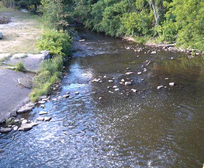
3 Section 1 Background The Mill Pond Dam was constructed in 1913 for waterpower development and subsequently purchased by the City of Flint as a supplemental reservoir for public water supply in the 1970 s. Under a lease agreement, the Village of Goodrich is responsible for operating and maintaining the dam. A general location map is provided in Figure 1. Figure 1 Location Map Mill Pond Dam 1.1 Michigan Department of Environmental Quality (MDEQ) Regulation Dam Safety Unit Requirements The following excerpt is from the Mill Pond Dam Safety Inspection dated June 5, On June 5, 2012, a Dam Safety Inspection was conducted and evaluated the structural condition and hydraulic capacity of this dam as required by Part 315, Dam Safety, of the Natural Resources and Environmental Protection Act, 1994 PA 451, as amended. The results of this inspection documented that the dam is in fair condition overall. Based on observations at the time of the inspection there were no apparent structural deficiencies that may lead to the immediate failure of the dam. However, the structural elements of the dam continue to deteriorate. The dam has adequate spillway capacity to pass the design flood only if all stoplogs and lift gates are removed from the dam, which is questionable during high flow conditions. The following recommended actions are listed by priority. Goodrich Mill Pond 1. Update the current operation and maintenance (O&M) plan by December 31, 2012, to include powerhouse stoplog removal. If modifications are needed in order to reliably remove the stoplogs Village of Goodrich - Mill Pond Dam Modifications Feasibility Study 1
4 during a flood, these modifications should be made by May 1, This was requested in 2004 and 2008 inspections and has not yet been completed. It is essential to be able to remove the stoplogs and lift gates from all five spillway bays in order to safely pass the design flood. 2. Remove the trees and brush growing near the left downstream abutment wall as well as any trees and brush growing through the concrete cap on the right downstream embankment by May 1, Provide photos to the Dam Safety Program of these areas once the trees and brush have been removed. 3. Within five years, develop a long-term plan for the future of the dam. This plan should include a structural analysis for the long-term stability of the dam as well as a feasibility study for repair, replacement, or removal of the spillway. When complete, provide a copy of the plant to the Dam Safety Program. 4. Monitor embankments for seepage and erosion on a quarterly basis. 5. In conjunction with the Genesee County Emergency Management, review and update the Emergency Action Plan (EAP) for the dam by December 31, Provide a copy of the updated plan to the Dam Safety Program. The significant hazard potential rating for this dam remains appropriate. Since this report was issued, the Village has prepared and the MDEQ has accepted the Emergency Action Plan noted in action item Project Goals and Objectives During the planning workshop conducted with Village officials on April 3, 2013, project-specific goals and objectives were set to help guide the planning and design of the proposed modifications to the dam structure envisioned as a result of this effort. The following goals and objectives were identified: Goals: Ensure the dam is safe for the downstream community and public/ private infrastructure Save the Mill Pond impoundment for the community Develop an Action Plan for safely passing flows Determine funding options Aesthetics should be addressed in the dam improvements Maintain the use of the impoundment for Fire Protection as a water source Develop a plan that includes short-term as well as long-term actions Objectives: Preserve the dam impoundment Replace the gates to comply with MDEQ directives Use alternative funding sources including state, federal and private foundations to the greatest extent possible The Village officials intend to use these goals and objectives to screen for the preferred alternative short-term and long-term actions as prepared by the engineering team during the evaluation phase of this scope of work. Village of Goodrich - Mill Pond Dam Modifications Feasibility Study 2


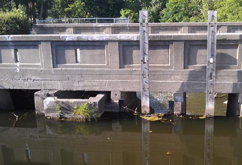
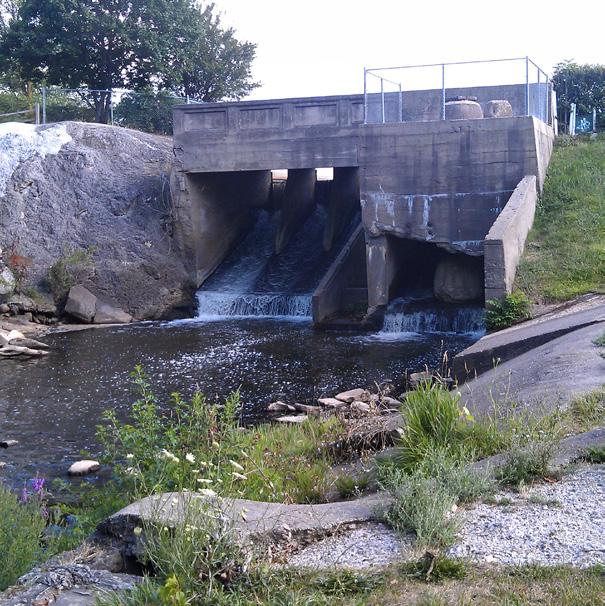
5 Section 2 Summary of Engineering Investigations The Wade Trim/Stantec Team performed visual inspections and reviewed published reports and public record data. In addition, Village staff and officials were interviewed about the maintenance and operation of the dam over the last several years. The engineering evaluation did not include any site-specific engineering testing or geotechnical investigations. Therefore, the recommendations that follow are based on qualitative assessments of the structure and surrounding site conditions. Limited additional topographic data was collected to support the hydraulic investigations performed as part of this work. However, this was limited to Hegel Road Bridge and the spillway canal area of the structure. short, concrete-lined channel that is in satisfactory condition prior to reaching the spillway crest. Flow through the principal spillway is controlled by lift gates consisting of stoplogs attached to lifting arms to facilitate lifting of the stoplogs. The spillway discharges to Kearsley Creek. Stop logs for the powerhouse area and fish ladder are not equipped with a lifting mechanism. Removal of these stoplogs is difficult during periods of high flow and is not considered to be in an operable state unless the impoundment is drawn down to an elevation below the stoplog crest. 2.1 Dam Structure The dam structure consists of earthen embankments with a structural height of 22 feet and a hydraulic height of 19.4 feet. It creates an impoundment with an estimated surface area of 14 acres. The 180-footlong left embankment has an approximate crest width of 135 feet, an approximate upstream slope of 2 horizontal to 1 vertical, and a downstream slope of 3 horizontal to 1 vertical. The 50-foot-long right embankment has an approximate crest width of 90 feet, an approximate upstream slope of 2 horizontal to 1 vertical, and a downstream slope of 1.5 horizontal to 1 vertical. The overall condition of the concrete principal spillway is poor. Deterioration of the concrete structure is pervasive as is common for older concrete structures that were not constructed with air-entrained concrete. Concrete repairs have been made throughout the structure. In addition, we noted concrete (flowable fill) has been poured under and around the spillway, most recently in Large voids in these areas of the spillway structure raise concern over the stability of the spillway. A more detailed engineering subsurface investigation should be performed as part of the long-term action plan for the dam repair. 2.2 Hydrology and Hydraulics Two powerhouse gates and a fish ladder gate at the far left of the spillway structure are not considered operable at high water elevations. A spillway channel exists under Hegel Road as well as a spillway with six stoplog controlled bays as shown in the adjacent photos. The overflow spillway is controlled by three 5.2-foot-wide stoplog bays, and flow through the former powerhouse is controlled by two 5.5-foot-wide stoplog bays. Flow through the fish ladder is controlled by a single, 5.2-foot-wide stoplog bay. Prior to reaching the spillway crest, flow from the Goodrich Mill Pond passes under the Hegel Road Bridge through a The contributing drainage area of Kearsley Creek at the Mill Pond Dam and upstream impoundment is approximately 52 square miles. Based on information provided in the Dam Safety Inspection Report-MDEQ, dated June 5, 2012, the design discharge rate from the 200-year design storm is 1,580 cubic feet per second (cfs). The capacity of the dam spillway is controlled using three small and two large control gates that are manually operated by Goodrich staff. Currently only the three small control gates Three operable gates located at the far right of the spillway structure are used to control overflow. Village of Goodrich - Mill Pond Dam Modifications Feasibility Study 3

 elevation of 875.5 feet immediately upstream of the dam.")
6 Goodrich Park will become more directly connected to the floodplain with the proposed dam improvements. are operable while the two larger gates remain fixed in a closed position without any means of operation. The dam spillway was designed with the intent of having all 5 gates fully operational. Recent hydraulic calculations show that with all five gates in a fully open position, the 200-year-design flow of 1,580 cfs can safely pass through the spillway while maintaining an acceptable hydraulic grade line (HGL) elevation of feet immediately upstream of the dam. However, with only the three smaller gates; those that are currently operational and raised to the fully open position, the maximum passable flow while maintaining the same upstream HGL of feet is approximately 740 cfs. In order to pass the full 1,580 cfs design flow, the upstream HGL must increase. This increased HGL causes higher floodplain elevations upstream in the impoundment that may result in overtopping of the roadway and the earthen embankment at an area near the existing bridge and spillway channel. 2.3 Survey Data Collection To predict the potential hydraulic conditions and determine critical grades for conceptualizing the alternative solutions, the design team collected additional topographic elevations at critical areas of the existing dam structure and embankment. Figure 2 summarizes the grades and elevations collected during this survey. All grades are based on a benchmark control point #100; a 5/8 Iron with Brass Disk in Goodrich Park on NAVD88 survey datum. Figure 2 Topographic Elevations Elevation Description Chiseled X top of wall between gates 1 & 2 (BM # 5) Top of concrete of fish hute Bottom of Slab 5 (westerly most gate) Bottom of Slab Bottom of Slab Bottom of Slab Bottom of Slab 1 (easterly most gate) Top of storage (abutment wall) east side Top of storage (abutment wall) west side River bottom between bridge and dam - assumed concrete bottom River bottom - lake side, south of bridge Low beam on Hegel Bridge (north side of bridge) Lake elevation mark (west side of bridge) Water surface elevation north of dam Water surface elevation between dam and Hegel Bridge Water surface elevation - lake side, south of bridge Water surface and lake bottom elevations surveyed during this assessment indicate the Mill Pond water depth is reducing from sedimentation. In some cases, bottom sediments were noted to be less than 8 feet below the water surface. Sedimentation within the Mill Pond will be a significant aesthetic and functional change in the Mill Pond. Dredging costs were not evaluated in this effort, but are estimated to be significantly higher than the costs of any of the long-term alternative action plans. Hungry water downstream of the dam has caused large areas of the existing banks to erode, especially near the spillway stilling basin at the bottom of the spillway flumes. Village of Goodrich - Mill Pond Dam Modifications Feasibility Study 4
7 Section 3 Recommendations A matrix of feasible short-term and long-term alternatives to meet the MDEQ requirements and address the aging dam structure was developed. A range of short- and long-term options were evaluated during the April 3, 2013, workshop with Village officials and project stakeholders. Short-term actions evaluated: Repair powerhouse gates to be operative Replace powerhouse gates with new gates By-pass high flows with lower road surface for Hegel Road Construct a downstream coffer dam to contain Mill Pond Lower the impoundment s water surface level Construct a high flow by-pass channel Long-term actions evaluated: Repair/replace dam with active gates Remove dam and replace with a principal channel rock ramp and auxiliary spillway Remove the dam Remove dam and place an upstream weir/step structure 3.1 Preferred Short-Term Action Plan for Mill Pond Dam Based on the qualitative engineering evaluations performed during the dam condition assessment phase, the Wade Trim/Stantec Team recommended the powerhouse gates either be replaced or repaired to be operative as required by the MDEQ in their latest correspondence with the Village. As a result of the dam modification study alternatives workshop conducted on April 3, 2013, with Village officials and project stakeholders, this short-term action was preferred due to its straightforward approach and relatively low cost to implement. After the workshop, the Wade Trim/Stantec Team investigated the feasibility of modifying the gates to have a 3-foot removable section on top and a fixed lower portion. This modification was investigated relative to the hydraulic performance of the dam structure and deemed to be an acceptable alternative. Sequencing of the permitting, engineering and implementation of this recommended solution includes: 1. Conduct a pre-application conference with the MDEQ Dam Safety Unit to include a summary of the proposed repair sequence and the necessary hydraulic calculations to support the powerhouse gate repair. 2. Prepare and submit an MDEQ Part 315 permit application for the gate repair. 3. Lower the impoundment elevation temporarily to eliminate any flow over the powerhouse gates to allow for inspection, engineering design and construction of the gate repair. 4. Develop plans and bidding documents and bid and construct the work as may be required by the Village. The work is estimated to be completed in no more than three months from the notice to proceed, dependent on weather conditions, permit approvals and the selected contractor s schedule. 3.2 Preferred Long-Term Action Plan for Mill Pond Dam Planning workshop participants evaluated a range of long-term actions that would provide for the ultimate long range plan for addressing the risks and liabilities of owning the dam. Given the cost and complexity of the long range plan, implementation of any of the solutions will be a significant public investment and require considerable coordination and time to coalesce the funding for a comprehensive solution to replacing the aged dam structure with a functional and cost effective dam structure. After the long-term solutions were evaluated, three preferred alternatives were selected that are generally similar in function, benefits and expected cost, but not necessarily in form. Village of Goodrich - Mill Pond Dam Modifications Feasibility Study 5
8 Preferred Long-term Alternative 1 Alternative 1 moves the spillway from the existing dam structure downstream in the form of a rock ramp grade control structure as shown in Figure 3. This concept sets the invert at a slightly lower impoundment elevation of (Existing 874) and proposes high flows to be routed across an expansive overflow berm into the existing floodplain in Goodrich Park. The overflow berm would be constructed in a manner to channel the regular base flow and high frequency flows across the rock ramp. However, flood flows would crest over the overflow berm in a controlled manner on the downstream side of the dam. The overflow berm would be constructed of a rock/soil matrix and heavily landscaped pockets with deep rooting native grasses and forbs to further protect the overflow berm from erosion during high flow events. Because these high flows would be infrequent and crest across a broad overflow area, erosive velocities would be minimized and the existing floodplain would be accessed across a broad area of the existing park. The alternative will require installation of a seepage cutoff along the entire length of the containment area for the downstream impoundment at both the rock ramp channel and the auxiliary overflow channel. The containment dike could be constructed of either steel sheet pile or a slurry trench. The existing dam structure would remain in place, however, all the existing stoplog gates would be removed to allow a free flowing condition through the structure, thereby greatly reducing stress from hydraulic loading on the existing structure. The top of the existing structure is proposed to be repurposed to allow for public observation of the expanded impoundment area created downstream by the proposed rock ramp structure. Alternative 1 benefits: Passive management of flows; no gate operation or related maintenance is required Improved public recreational opportunities in Goodrich Park with the addition of the impoundment area for fishing and passive waterfront access Improved landscape quality of Goodrich Park with the addition of the heavily planted berm and rock ramp cascade Preservation of the historic Mill Pond Dam structure for community interest and historic/cultural interpretation of the former mill and history of the region Preserves water supply capacity as a result of the expanded impoundment area Preferred Long-term Alternative 2 Alternative 2, shown in Figure 4, moves the spillway upstream, south of the existing dam spillway and the Hegel Road Bridge. The new spillway structure is designed to be multi-functional to control the water level of the impoundment, implement a seepage cutoff, and provide an elevated recreational overlook/fishing access promenade. The proposed spillway is sized with a weir length capable of passing the critical storm flow. The top of the first rock ramp is to be set approximately 4 feet below the top of the spillway. Normal flows will pass from the spillway through the proposed rock ramps and the existing channel of Kearsley Creek. However, high flows will overtop the bank of the channel and spill into the existing floodplain within Goodrich Park. Both banks of Kearsley Creek will be stabilized with bioengineering to prevent scour of the banks and provide restored riparian habitat within the park. The pedestrian promenade over the spillway will allow improved public access to the Mill Pond for passive recreation including fishing. An access area will be located at the eastern edge to allow canoe and kayak launching. Pedestrian connections will be added to the sidewalks along Hegel Road as well as pedestrian connections along the Kearsley Creek channel in Goodrich Park. Alternative 2 benefits: Passive management of flows; no gate operation or related maintenance is required Improved recreational opportunities in Goodrich Park with the addition of public access to the Mill Pond for fishing and nonmotorized boating access Improved landscape quality of Goodrich Park, restored creek channel and stabilized banks Preferred Long-term Alternative 3 After reviewing Alternatives 1 and 2, the workshop participants evaluated a hybrid of the two alternatives which essentially combines the most desired features and qualities into a single hybrid concept. Alternative 3, shown in Figure 5, combines the expanded recreational benefits found in Alternative 2 with the downstream passive control of the impoundment as detailed in Alternative 1. Alternative 3 includes a canoe and kayak launch on the south main Mill Pond area as well as a fishing access platform at the eastern edge of the Mill Pond along Hegel Road. In addition, a pedestrian path across the existing dam structure is extended along the top of the overflow berm and enhanced with fishing access overlooks at strategic points including the top of the rock ramp near the principal channel crest. Alternative 3 benefits: Passive management of flows; no gate operation or related maintenance is required Improved public recreational opportunities in Goodrich Park with the addition of the impoundment area for fishing and passive waterfront access Improved landscape quality of Goodrich Park with the addition of the heavily planted berm and rock ramp cascade Improved public access to the historic Mill Pond impoundment for non-motorized boating and fishing Preservation of the existing dam structure as a public historic amenity and recreational overlook space Preserves water supply capacity as a result of the expanded impoundment area Village of Goodrich - Mill Pond Dam Modifications Feasibility Study 6

9 M - 15 Figure 3 Alternative 1 Site Plan Bank Stabilization and Restored Riparian Area Principal Channel Rock Ramp Auxiliary Overflow Enhanced Landscape Treatment at Public Parking Area Preserved Historic Mill Pond Dam Hegel Road North Village of Goodrich - Mill Pond Dam Modifications Feasibility Study 7

10 M - 15 Figure 4 Alternative 2 Site Plan Bank Stabilization and Restored Riparian Area Rock Ramp No. 2 Rock Ramp No. 1 Existing Public Parking Area Hegel Road Spillway and Cascade Water Feature Pedestrian Promenade and Fishing Access North Village of Goodrich - Mill Pond Dam Modifications Feasibility Study 8

11 M - 15 Figure 5 Alternative 3 Site Plan Rock Ramp Spillway Auxiliary Overflow Pedestrian Path and Fishing Access Expanded Spillway Basin Overlook and Preserved Historic Mill Pond Dam *All Gates Removed Enhanced Landscape Treatment at Public Parking Area Hegel Road Fishing Platform Canoe / Kayak Launch North Village of Goodrich - Mill Pond Dam Modifications Feasibility Study 9
12 Section 4 Conceptual Opinions of Probable Construction Costs Figure 6 Short-Term Actions Cost Estimate Item No. Description Quantity Unit Unit Cost Extension Temporary Modifications to Powerhouse Inlet Gates 1 Mobilization and site access 1 LS $5,000 $5,000 Remove top 3 feet of old sluice gates, install bracing 2 angle on remaining gate 2 EA $1,000 $2,000 3 Install 2 x 3 angles on inside wallface 4 EA $900 $3,600 4 Construct new 5.5 w x 3 high wooden gates with lift plank 2 EA $2,200 $4,400 5 Install new gates 2 EA $750 $1,500 6 Demobilize and cleanup 1 LS $1,000 $1,000 7 Contingency (25%) 1 LS $4,000 $4,000 TOTAL $21,500 NOTE: Other project costs including grant assistance, design engineering, permitting, construction engineering, and legal and bond counsel, are not included in this table. Figure 7 Long-Term Alternatives Cost Estimates Item No. Description Quantity Unit Unit Cost Extension Alternative 1 1 Mobilization (5%) 1 LS $79,146 $79,146 2 Dam Gate Removal-Selective Demolition 1 LS $7,500 $7,500 3 Paving and Grading of Parking Area 3,085 SF $8 $24,680 4 Sheetpile Cutoff Wall along Auxillary Overflow and Main Channel 305 LF $1,600 $488,000 5 Rock Ramp Construction (Assume 2 feet of Boulder Mix over engineered soil 1,214 Tons $75 $91,050 6 Rock Ramp Engineered Fill (Assume 6 Feet Avg Depth) 2,043 Tons $35 $71,505 7 Overflow embankment ( Assumes 3 feet of Boulder/Soil Mix and Fill Material) 5,600 Tons $65 $364,000 8 Earthwork -Excavation and Grading 200 CY $14 $2,800 9 Bioengineering Bank Stabilization and Riparian Plantings- Low Bank Area 4,092 SF $15 $61, Bioengineering Bank Stabilization and Riparian Plantings- High Bank Area 12,400 SF $30 $372, Landscape Planting at Overflow and Parking Area 1 LS $100,000 $100, Contingency (25%) 1 LS $415,515 $415,515 TOTAL $2,078,000 NOTE: Other project costs including grant assistance, design engineering, permitting, construction engineering, and legal and bond counsel, are not included in this table. NOTE: The engineer has no control over the cost of labor, materials, equipment, or services furnished by others, or over the contractor s method of determining prices, or over competitive bidding or market conditions. Opinions of probable project costs and construction costs provided herein are made on the basis of the engineer s professional judgment and experience. The engineer cannot and does not guarantee that proposals, bids or actual project or construction costs will not vary from the prepared opinion of probable cost. Village of Goodrich - Mill Pond Dam Modifications Feasibility Study 10
13 Figure 7 Long-Term Alternatives Cost Estimates (cont d.) Item No. Description Quantity Unit Unit Cost Extension Alternative 2 1 Mobilization (5%) 1 LS $79,251 $79,251 2 Dam Structure Removal 1 LS $50,000 $50,000 3 Concrete Cascades below spillway 415 LF $130 $53,950 4 Sheetpile Cutoff at Spillway 326 LF $1,600 $521,600 5 Concrete Wingwall at Spillway 148 LF $150 $22,200 6 Concrete Promenade with Concrete Baluster and Lighting 3,083 SF $80 $246,640 7 Plantings at Spillway Structure 1,900 SF $2 $3,800 8 Rock Ramp Construction - Upper Ramp 690 Tons $75 $51,750 9 Rock Ramp-Upper Ramp Engineered Fill (8 Ft Avg Depth) 1,840 Tons $35 $64, Rock Ramp Construction - Lower Ramp 661 Tons $75 $49,575 Rock Ramp- Lower Ramp Engineered Fill (3.5 Ft Avg 11 Depth) 771 Tons $35 $26, Earthwork -Excavation and Grading 200 CY $14 $2,800 Bioengineering Bank Stabilization and Riparian Plantings- 13 Low Bank Area 10,423 SF $15 $156, Bioengineering Bank Stabilization and Riparian Plantings- High Bank Area 11,166 SF $30 $334, Contingency (25%) 1 LS $416,069 $416,069 TOTAL $2,080,345 NOTE: Other project costs including grant assistance, design engineering, permitting, construction engineering, and legal and bond counsel, are not included in this table. Item No. Description Quantity Unit Unit Cost Extension Alternative 3 Estimate of Probable Construction Costs 1 Mobilization (5%) 1 LS $95,293 $95,293 2 Dam Gate Removal-Selective Demolition 1 LS $7,500 $7,500 3 Paving and Grading of Parking Area 3,085 SF $8 $24,680 4 Sheetpile Cutoff Wall along Auxillary Overflow & Main Channel 305 LF $1,600 $488,000 5 Rock Ramp Construction (Assume 2 feet of Boulder Mix over engineered soil 1,214 Tons $75 $91,050 6 Rock Ramp Engineered Fill (Assume 6 Feet Avg Depth) 2,043 Tons $35 $71,505 7 Overflow embankment ( Assumes 3 feet of Boulder/Soil Mix and Fill Material) 5,600 Tons $65 $364,000 8 Pedestrian Path Fishing Access Lower Impoundment 2,546 SF $12 $30,552 9 Canoe/Kayak Launch Platform 2,065 SF $80 $165, Fishing Access Platform 1,590 SF $80 $127, Earthwork -Excavation and Grading 200 CY $14 $2,800 Bioengineering Bank Stabilization and Riparian Plantings- 12 Low Bank Area 4,092 SF $15 $61,380 Bioengineering Bank Stabilization and Riparian Plantings- 13 High Bank Area 12,400 SF $30 $372, Landscape Planting at Overflow and Parking Area 1 LS $100,000 $100, Contingency (25%) 1 LS $500,290 $500,290 TOTAL $2,501,450 NOTE: Other project costs including grant assistance, design engineering, permitting, construction engineering, and legal and bond counsel, are not included in this table. Village of Goodrich - Mill Pond Dam Modifications Feasibility Study 11

14 Section 5 Implementation and Funding Alternatives The key to implementing the alternatives considered in this study is to consider replacing the Mill Pond Dam as a long-range plan with a broad foundation for continuing community focus and convergence on waterfront access, resource protection, recreation improvements and water management infrastructure in the Village of Goodrich. The Village should view the long-range plan as a multi-objective master plan that will be implemented over an extended time horizon. Implementation will require the Village to be flexible and continually update the plan as it moves forward in the years ahead. It is not unrealistic to think that the program elements in this study could take a decade or more to complete. Major steps to include are: 1. Adopt an MDEQ-approved community recreation plan that includes a project-specific Master Plan for the Mill Pond area 2. Determine who will lead and manage implementation of the plan 3. Communicate the plan 4. Prepare preliminary specific plan phases for the project area 5. Design/engineer and implement project phases as funding is procured Having local leadership and administration demonstrates local commitment to the project and bridges the gap of various county, state and federal funding sources. This local commitment can be realized by establishing a project-specific task force that will provide direction and continuity of intent through multiple phases of development and changes in leadership within the Village. In the absence of a dedicated funding program for dam rehabilitation and removal in Michigan, alternatives funding sources are limited. However, if the proposed modifications to the existing dam can be framed within a broader set of public improvements such as recreation, open space, and natural resource enhancements, the overall project may secure funding from an expanded pool of resources. This approach to funding is relatively new, yet the sources shown in Figure 8 are believed to be eligible to coalesce into a funding pool for a large part of the potential costs associated with any of the long-term alternatives. Figure 8 Potential Funding Sources for Mill Pond Dam Modifications Funding Agency Program Funding Michigan Department of Natural Resources Dam Management Grant Program $2.35 M (2012)* Natural Resources Trust Fund $6.8 M (2012)* Inland Fisheries $5K - $200K 50% of total cost Michigan State Historic Preservation Office Historic Preservation Grant Program Matching Grant in Aid Federal Emergency Management Agency Pre-Disaster Mitigation Grants Federal to Non-Federal Private Foundations TBD Varies * Total available funding for the fiscal year Village of Goodrich - Mill Pond Dam Modifications Feasibility Study 12
15 555 S. Saginaw Street Suite 201 Flint, MI Florida Michigan Nebraska Ohio Pennsylvania Texas
ROLE OF THE FIRM IN THE PROJECT
 PROJECT DESCRIPTION Lake Loramie Dam is a Class I dam located in Lake Loramie State Park in Minster, Ohio. Lake Loramie originally served as the high feeder water supply for the Miami-Erie Canal that began
Ceresco Dam Removal Project. Michigan Watershed Summit March 25, 2015 Luke Trumble, P.E., MDEQ-WRD Jay Wesley, MDNR-Fisheries
 Ceresco Dam Removal Project Michigan Watershed Summit March 25, 2015 Luke Trumble, P.E., MDEQ-WRD Jay Wesley, MDNR-Fisheries Outline Overview of Ceresco Dam History Public Process Funding Dam Removal Ecosystem
Lyon Creek Cedar Way Stormwater Detention Dam Operation and Maintenance Manual
 Lyon Creek Cedar Way Stormwater Detention Dam Operation and Maintenance Manual Prepared by: Mike Shaw Stormwater Program Manager City of Mountlake Terrace January 2010 Section I General Information This
Supplemental Watershed Plan Agreement No. 10 for Neshaminy Creek Watershed Core Creek Dam (PA-620) Bucks County, Pennsylvania
 Bucks County, Pennsylvania") Supplemental Watershed Plan Agreement No. 10 for Neshaminy Creek Watershed Core Creek Dam (PA-620) Bucks County, Pennsylvania Project Authorization USDA's Small Watershed Program is carried out under the
Supplemental Watershed Plan Agreement No. 10 for Neshaminy Creek Watershed Core Creek Dam (PA-620) Bucks County, Pennsylvania Project Authorization USDA's Small Watershed Program is carried out under the
January 23, 2018 PREPARED BY: SPICER GROUP, INC.
 UPPER STRAITS LAKE LEVEL CONTROL STRUCTURE TOWNSHIP OF WEST BLOOMFIELD, OAKLAND COUNTY, MI. PREPARED FOR: OAKLAND COUNTY WATER RESOURCES COMMISSIONER JIM NASH PREPARED BY: SPICER GROUP, INC. January 23,
CONSTRUCTION PLAN CHECKLIST
 CONSTRUCTION PLAN CHECKLIST The design engineer is responsible for ensuring that plans submitted for city review are in accordance with this checklist. It is requested that the executed checklist be submitted
Appendix D - Evaluation of Interim Solutions
 Appendix D - Evaluation of Interim Solutions D.1 Introduction The implementation of long-term improvements is projected to take 5 to 8 years. To reduce the number of years of flooding impacts, the partner
AMERICAN ELECTRIC POWER (SWEPCO)
") 2016 DAM & DIKE INSPECTION REPORT ASH PONDS GERS-16-163 WELSH POWER PLANT AMERICAN ELECTRIC POWER (SWEPCO) CASON, TEXAS NATIONAL INVENTORY NO. TX4357 PREPARED BY GEOTECHNICAL ENGINEERING AEP SERVICE CORPORATION
2016 DAM & DIKE INSPECTION REPORT ASH PONDS GERS-16-163 WELSH POWER PLANT AMERICAN ELECTRIC POWER (SWEPCO) CASON, TEXAS NATIONAL INVENTORY NO. TX4357 PREPARED BY GEOTECHNICAL ENGINEERING AEP SERVICE CORPORATION
Via October Mr. William Neal, P.E. Technological Specialist DTE Electric Company One Energy Plaza Detroit, MI 48226
 17 October 2016 134 N. La Salle Street, Suite 300 Chicago, Illinois 60602 PH 312.658.0500 FAX 312.658.0576 www.geosyntec.com Via Email Mr. William Neal, P.E. Technological Specialist DTE Electric Company
UPPER STRAITS LAKE LEVEL CONTROL STRUCTURE TOWNSHIP OF WEST BLOOMFIELD, OAKLAND COUNTY, MI.
 1 UPPER STRAITS LAKE LEVEL CONTROL STRUCTURE TOWNSHIP OF WEST BLOOMFIELD, OAKLAND COUNTY, MI. PREPARED FOR: OAKLAND COUNTY WATER RESOURCES COMMISSIONER JIM NASH PREPARED BY: SPICER GROUP, INC. December
Travers Reservoir Rehabilitation Project Irrigation Technical Conference Lethbridge, AB June 2, 2010
 Travers Reservoir Rehabilitation Project 2010 Irrigation Technical Conference Lethbridge, AB June 2, 2010 Location Plan Western Irrigation District Headworks CALGARY Eastern Irrigation District Headworks
DRAFT MASTER PLAN RICHFIELD HERITAGE PRESERVE. Environmental OCTOBER 2016
 DRAFT MASTER PLAN RICHFIELD HERITAGE PRESERVE OCTOBER 2016 Environmental DesignGroup STREETSBORO RD SITE BROADVIEW ROAD RICHFIELD HERITAGE PRESERVE 336 ACRES CLEAN OHIO CLEAN OHIO OVIATT RD RECAP FEBRUARY
Created by Simpo PDF Creator Pro (unregistered version) Asst.Prof.Dr. Jaafar S. Maatooq
 Asst.Prof.Dr. Jaafar S. Maatooq") Lect.No.9 2 nd Semester Barrages, Regulators, Dams 1 of 15 In order to harness the water potential of a river optimally, it is necessary to construct two types of hydraulic structures, as shown in Figure
Lect.No.9 2 nd Semester Barrages, Regulators, Dams 1 of 15 In order to harness the water potential of a river optimally, it is necessary to construct two types of hydraulic structures, as shown in Figure
AMERICAN ELECTRIC POWER (SWEPCO)
") 2015 DAM & DIKE INSPECTION REPORT ASH PONDS GERS-15-034 WELSH POWER PLANT AMERICAN ELECTRIC POWER (SWEPCO) CASON, TEXAS NATIONAL INVENTORY NO. TX4357 PREPARED BY GEOTECHNICAL ENGINEERING AEP SERVICE CORPORATION
2015 DAM & DIKE INSPECTION REPORT ASH PONDS GERS-15-034 WELSH POWER PLANT AMERICAN ELECTRIC POWER (SWEPCO) CASON, TEXAS NATIONAL INVENTORY NO. TX4357 PREPARED BY GEOTECHNICAL ENGINEERING AEP SERVICE CORPORATION
STORM DRAINAGE DESIGN MANUAL
 Appendix I STORM DRAINAGE DESIGN MANUAL by: SUNGATE DESIGN GROUP, P.A. GEN ERAL DESIGN STAN DARDS AN D POLICIES 1. STREET AND LOCAL DRAINAGE Discharge estimates for specified design storms shall be calculated
C43 West Basin Storage Reservoir. Hendry County Commission January 22, 2019
 C43 West Basin Storage Reservoir Hendry County Commission January 22, 2019 Project Location SFWMD Trailer Compound C-43 Reservoir Townsend Canal Perimeter Dam Appox. 6 Mi C-43 Reservoir Separator Dam Perimeter
McElroy s Run Impoundment Structural Stability Assessment Report
 Allegheny Energy Supply Company, LLC A FirstEnergy Company Pleasants Power Station Pleasants County, West Virginia October 2016 Prepared for: Allegheny Energy Supply Company, LLC A FirstEnergy Company
DTE Energy Monroe Power Plant
 DTE Energy Monroe Power Plant Inactive Bottom Ash Impoundment CCR Rule Compliance Project Annual Inspection Report - 2018 Project Number: 60516675 September 7, 2018 Prepared by: 27777 Franklin Road, Suite
SECTION GENERAL EXCAVATION
 02210-1 of 11 SECTION 02210 GENERAL EXCAVATION 02210.01 GENERAL A. Description 1. General excavation shall include but not necessarily be limited to, excavation and grading for general site work, roadways,
The inspection report evaluates potential Path 1. The hydraulic analysis report evaluates potential Path 2.
 FINAL March 15, 2013 Mr. Daniel Richardson Construction and Acquisition 5600 American Blvd. West, Suite 990 Bloomington, MN 55437-1458 Dear Mr. Richardson: Subject: Union Street Dam Inspection Services
SECTION SITE GRADING. Part 1 - General Work Included Related Requirements Reference Standards...
 SECTION 02210 - SITE GRADING CONTENTS: Part 1 - General... 1 1.01 Work Included... 1 1.02 Related Requirements... 1 1.03 Reference Standards... 1 1.04 Quality Assurance... 1 1.05 Measurement and Payment...
Mr. Michael Malone CPS Energy 145 Navarro Street San Antonio, Texas Project No
 Environmental Resources Management January 13, 2017 Mr. Michael Malone 145 Navarro Street San Antonio, Texas 78205 Project No. 0352436 CityCentre Four 840 West Sam Houston Parkway North, Suite 600 Houston,
Jacobi, Toombs, and Lanz, Inc.
 Area 5: Blackiston Mill Road at Dead Man's Hollow Flooding Assessment Jacobi, Toombs, and Lanz, Inc. This document summarizes an assessment of drainage and flooding concerns and provides recommendations
GRADING, EROSION AND SEDIMENTATION CONTROL
 SECTION 500 GRADING, EROSION AND SEDIMENTATION CONTROL 501 Erosion and Sedimentation Control Plan All engineering plans for projects that propose to construct new, or modify existing drainage facilities,
Preliminary Engineering Report. For the. Foxglove Trail. Prepared for: The City of Moore. Prepared By:
 Preliminary Engineering Report For the Foxglove Trail Prepared for: The City of Moore Prepared By: Certificate of Authorization No. CA#5714 Expires June 30, 2016 CE Project #264 May 2016 City of Moore
BLOCKING AND FILLING SURFACE DRAINAGE DITCHES
 MINNESOTA WETLAND RESTORATION GUIDE BLOCKING AND FILLING SURFACE DRAINAGE DITCHES TECHNICAL GUIDANCE DOCUMENT Document No.: WRG 4A-1 Publication Date: 10/14/2015 Table of Contents Introduction Application
WASTE TREATMENT LAGOON
 359-1 NATURAL RESOURCES CONSERVATION SERVICE CONSERVATION PRACTICE STANDARD WASTE TREATMENT LAGOON (No.) CODE 359 DEFINITION A waste treatment impoundment made by constructing an embankment and/or excavating
Section 6: Stormwater Improvements
 Section 6: Stormwater Improvements A major objective of this study was to identify opportunities for improvements to address the widespread water quality impairments caused by stormwater runoff in the
Project Information. Pursuant to Section 404 of the Clean Water Act (33 U.S. Code 1344), notice is hereby given that
, notice is hereby given that") US ARMY Corps Of Engineers Little Rock District JOINT PUBLIC NOTICE CORPS OF ENGINEERS STATE OF MISSOURI Application Number: SWL 2013-00260 Date: April 15, 2014 Comments Due: May 6, 2014 TO WHOM IT MAY
US ARMY Corps Of Engineers Little Rock District JOINT PUBLIC NOTICE CORPS OF ENGINEERS STATE OF MISSOURI Application Number: SWL 2013-00260 Date: April 15, 2014 Comments Due: May 6, 2014 TO WHOM IT MAY
CCR Annual Inspection (b) for the Ash Pond at the A.B. Brown Generating Station. Revision 0
 for the Ash Pond at the A.B. Brown Generating Station. Revision 0") Submitted to Southern Indiana Gas & Electric Company dba Vectren Power Supply, Inc. (SIGECO) One Vectren Square Evansville, IN 47708 Submitted by AECOM 9400 Amberglen Boulevard Austin, Texas 78729 257.83
Submitted to Southern Indiana Gas & Electric Company dba Vectren Power Supply, Inc. (SIGECO) One Vectren Square Evansville, IN 47708 Submitted by AECOM 9400 Amberglen Boulevard Austin, Texas 78729 257.83
Conceptual-Level Cost Estimates Arkansas River Corridor Dam Improvement and River Bank Stabilization Projects
 TECHNICAL MEMORANDUM Conceptual-Level Cost Estimates Arkansas River Corridor Dam Improvement and River Bank Stabilization Projects TO: COPIES: PREPARED BY: Tulsa County File CH2M HILL DATE: September 2,
DESIGN GRADING AND EROSION CONTROL A. Slope Criteria
 Section 5. DESIGN GRADING AND EROSION CONTROL A. Slope Criteria Earthen slopes shall conform to the following: Maximum slope should not be steeper than 6:1 (horizontal to vertical) unless protected from
5/25/2017. Lumpkin Detention Basin Houston, Texas By Brian Whitney, P.E., CFM Victor Rendon. Lumpkin Basin. Lumpkin Road Overall Description
 Lumpkin Detention Basin Houston, Texas By Brian Whitney, P.E., CFM Victor Rendon TEXAS FLOODPLAIN MANAGEMENT ASSOCIATION April 27, 2017 PROJECT LOCATION PROJECT VICINITY MAP Lumpkin Road Overall Description
4. Present Activities and Roles
 4. Present Activities and Roles The present missions, authorities, activities and roles of the various agencies involved with flood protection, floodplain management and flood-damage reduction are identified
TOLEDO BEND PROJECT FERC NO DRAFT LICENSE APPLICATION EXHIBIT E - ENVIRONMENTAL EXHIBIT 2.0 PROPOSED ACTION AND ALTERNATIVES
 TOLEDO BEND PROJECT FERC NO. 2305 DRAFT LICENSE APPLICATION EXHIBIT E - ENVIRONMENTAL EXHIBIT 2.0 PROPOSED ACTION AND ALTERNATIVES May 2011 Copyright 2011.Sabine River Authority of Texas and Sabine River
Presentation Overview
 Little Dry Creek Restoration Deep River Flood Risk Management Final Presentation to LCRBDC June 10, 2015 Presentation Overview Project Overview & Background Information Data Collection Model Development
CITY OF JENKS EARTH CHANGE PERMIT APPLICATION
 CITY OF JENKS EARTH CHANGE PERMIT APPLICATION Any applicable State or Federal permits must be attached to this application or must be applied for with copies attached to this application if this permit
SACRAMENTO SUPPLEMENTAL PROJECTS OVERVIEW
 1 SACRAMENTO SUPPLEMENTAL PROJECTS OVERVIEW 131 132 122 8 119 27 252 174.59 11 135 12 112 92 56 CAMERON SESSIONS SUPPLEMENTAL PROGRAM MANAGER 239 65 53 18 October 218 - American River Common Features WRDA
PRELIMINARY SHORELINE PROTECTION STUDY Parking Lot D to the JFK Library
 PREPARED FOR: UNIVERSITY OF MASSACHUSETTS BOSTON PRELIMINARY SHORELINE PROTECTION STUDY Parking Lot D to the JFK Library UNIVERSITY OF MASSACHUSETTS Boston, Massachusetts PREPARED BY: PARE CORPORATION
ASSESSMENT OF DESIGN ALTERNATIVES FOR MODIFICATION OR REMOVAL
 WBK ENGINEERING, LLC ENGINEERS SCIENTISTS PLANNERS MEDIATING THE BUILT AND NATURAL ENVIRONMENTS HAMMEL WOODS DAM 07.14.2017 (Updated 11.15.2017) FOREST PRESERVE DISTRICT OF WILL COUNTY ASSESSMENT OF DESIGN
REMOVING/RELOCATING DRAINAGE LIFT STATIONS
 MINNESOTA WETLAND RESTORATION GUIDE REMOVING/RELOCATING DRAINAGE LIFT STATIONS TECHNICAL GUIDANCE DOCUMENT Document No.: WRG 4A-5 Publication Date: 10/14/2015 Table of Contents Introduction Application
Application for a Dam Permit Ash Basin No. 1
 Application for a Dam Permit Ash Basin No. 1 for the Sunbury Generating Station Shamokin Dam, Pennsylvania submitted to Commonwealth of Pennsylvania Department of Environmental Protection Bureau of Waterways
LAKE CHEMUNG DAM LOCATION MAP
 LAKE CHEMUNG DAM LOCATION MAP LAKE CHEMUNG DAM OUTLET LAKE CHEMUNG DAM From: deq-wrd-qreq To: Steve Nagy Subject: RE: flood or low flow discharge request (ContentID - 168812) Date: Friday, June 26, 2015
Dawson County Public Works 25 Justice Way, Suite 2232, Dawsonville, GA (706) x 42228
 x 42228") Dawson County Public Works 25 Justice Way, Suite 2232, Dawsonville, GA 30534 (706) 344-3500 x 42228 DAWSON COUNTY STORM WATER REVIEW CHECKLIST Project Name: Property Address: Engineer: Fax #/Email: Date:
Dawson County Public Works 25 Justice Way, Suite 2232, Dawsonville, GA 30534 (706) 344-3500 x 42228 DAWSON COUNTY STORM WATER REVIEW CHECKLIST Project Name: Property Address: Engineer: Fax #/Email: Date:
APPLICATION FOR PUBLIC INFRASTRUCTURE PERMIT
 APPLICATION FOR PUBLIC INFRASTRUCTURE PERMIT Engineering Division 550 Landa Street New Braunfels, Texas 78130 (830) 221-4020 1. Subdivision Plat Name: Location Description/ Nearest Intersection: Acreage:
Stormwater Erosion Control & Post-Construction Plans (Stormwater Quality Plans)
") Stormwater Erosion Control & Post-Construction Plans (Stormwater Quality Plans) Allen County Stormwater Plan Submittal Checklist The following items must be provided when applying for an Allen County Stormwater
Stormwater Erosion Control & Post-Construction Plans (Stormwater Quality Plans) Allen County Stormwater Plan Submittal Checklist The following items must be provided when applying for an Allen County Stormwater
Suggested Stormwater Management Practices For Individual House Lots
 Suggested Stormwater Management Practices For Individual House Lots These practices are necessary to satisfy the water quantity and water quality criteria of the Rappahannock Stormwater Ordinance. These
HISTORY OF CONSTRUCTION 40 CFR (c)(1)(i)-(xii) PLANT WANSLEY ASH POND (AP-1) GEORGIA POWER COMPANY. Carrollton, Georgia 30116
(1)(i)-(xii) PLANT WANSLEY ASH POND (AP-1) GEORGIA POWER COMPANY. Carrollton, Georgia 30116") (i) Site Name and Ownership Information: HISTORY OF CONSTRUCTION 40 CFR 257.73(c)(1)(i)-(xii) PLANT WANSLEY ASH POND (AP-1) GEORGIA POWER COMPANY Site Name: Site Location: Site Address: Owner: Owner Address:
(i) Site Name and Ownership Information: HISTORY OF CONSTRUCTION 40 CFR 257.73(c)(1)(i)-(xii) PLANT WANSLEY ASH POND (AP-1) GEORGIA POWER COMPANY Site Name: Site Location: Site Address: Owner: Owner Address:
INITIAL INFLOW DESIGN FLOOD CONTROL SYSTEM PLAN PLANT MCMANUS ASH POND A (AP-1) 40 CFR
 40 CFR") INITIAL INFLOW DESIGN FLOOD CONTROL SYSTEM PLAN PLANT MCMANUS ASH POND A (AP-1) 40 CFR 257.82 EPA s Disposal of Coal Combustion Residuals from Electric Utilities Final Rule (40 C.F.R. Part 257 and Part
INITIAL INFLOW DESIGN FLOOD CONTROL SYSTEM PLAN PLANT MCMANUS ASH POND A (AP-1) 40 CFR 257.82 EPA s Disposal of Coal Combustion Residuals from Electric Utilities Final Rule (40 C.F.R. Part 257 and Part
Plan Rollout Presentation July 31, Michael G. Hahn, P.E., P.H. Chief Environmental Engineer. Southeastern Wisconsin Regional Planning Commission
 Plan Rollout Presentation July 31, 2014 Michael G. Hahn, P.E., P.H. Chief Environmental Engineer Southeastern Wisconsin Regional Planning Commission # 219703 Racine County Flooding Recommendations and
Good morning, Chairman Yaw, Chairman Yudichak, Chairman Vulakovich, Chairman Costa,
 Testimony of Patrick McDonnell, Secretary Pennsylvania Department of Environmental Protection Joint Hearing on Flooding and Emergency Response Senate Environmental Resources & Energy and Veterans Affairs
ENVIRONMENTAL RESOURCE PERMIT APPLICATION
 ENVIRONMENTAL RESOURCE PERMIT APPLICATION SOUTHWEST FLORIDA WATER MANAGEMENT DISTRICT 2379 BROAD STREET, BROOKSVILLE, FL 34604-6899 (352) 796-7211 OR FLORIDA WATS 1 (800) 423-1476 SECTION E INFORMATION
CLARIFICATIONS TO TECHNICAL SPECIFICATIONS SECTIONS
 C-44 Reservoir/STA System Discharge Project RFB: 6000000620 Addendum No. 1 March 2014 CLARIFICATIONS TO TECHNICAL SPECIFICATIONS SECTIONS HDR Engineering, Inc. SECTION 02401 DEWATERING, COFFERDAM AND BYPASS
CBC Aids WVDEP with Fresh Water Reservoir - Chief Logan State Park
 CBC Case Study-1212 1 of 5 CBC Aids WVDEP with Fresh Water Reservoir - Chief Logan State Park More Than Geotechnical Engineering DAYTON 125 Westpark Road Centerville, OH 45459 Phone: 937-428-6150 HAZARD
Chapter 6 Erosion & Stormwater Study Team
 Chapter 6 Erosion & Stormwater Study Team Objective How do we stabilize the Las Vegas Wash environment to most effectively reduce erosion and enhance wetlands? Introduction The Las Vegas Wash (Wash) has
TOWN OF MANCHESTER GENERAL SERVICES DEPARTMENT 494 MAIN STREET P.O. BOX 191 MANCHESTER, CONNECTICUT
 TOWN OF MANCHESTER GENERAL SERVICES DEPARTMENT 494 MAIN STREET P.O. BOX 191 MANCHESTER, CONNECTICUT 06045-0191 HILLIARD S POND DAM REMOVAL AND BIGELOW BROOK STREAM CHANNEL RESTORATION BID NO. 14/15-74
Appendix J Hydrology and Hydraulics
 Appendix J Hydrology and Hydraulics Marsh Lake Dam Ecosystems Restoration Feasibility Study Hydraulics & Hydrology Appendix January 2011 Contents List of Figures iii List of Tables iii I. General 1 II.
Old Mill School Stream Restoration
 Project Overview This conceptual plan restores and stabilizes two consecutive reaches of a highly incised and unstable stream and reconnects them with the floodplain. The restoration reaches are part of
Case Studies in Hazard Class Reductions Implementation of NY s Guidance for Dam Hazard Classification
 Case Studies in Hazard Class Reductions Implementation of NY s Guidance for Dam Hazard Classification Gregory J Daviero, PhD, PE, Principal Kevin Ruswick, PE, CFM, Associate May 2, 2014 Schnabel Engineering
HISTORY OF CONSTRUCTION 40 CFR (c)(1)(i) (xii) PLANT HAMMOND ASH POND (AP 2) GEEORGIA POWER COMPANY
(1)(i) (xii) PLANT HAMMOND ASH POND (AP 2) GEEORGIA POWER COMPANY") HISTORY OF CONSTRUCTION 40 CFR 257.73(c)(1)(i) (xii) PLANT HAMMOND ASH POND (AP 2) GEEORGIA POWER COMPANY (i) Site Name and Ownership Information: Site Name: Plant Hammond Site Location: Site Address:
HISTORY OF CONSTRUCTION 40 CFR 257.73(c)(1)(i) (xii) PLANT HAMMOND ASH POND (AP 2) GEEORGIA POWER COMPANY (i) Site Name and Ownership Information: Site Name: Plant Hammond Site Location: Site Address:
Submittal Requirements. Post Construction Verification Document Plan Requirements
 Submittal Requirements Post Construction Verification Document survey plan in accordance with the items of this Checklist Supporting calculations in accordance with the items of this Checklist A copy of
V. DRAINAGE IMPROVEMENTS
 V. DRAINAGE IMPROVEMENTS 5.1 Formulation of Drainage Improvements As indicated in Chapter 4, following the completion of the hydrologic analysis associated with future land use conditions, drainage improvements
DESIGN OF CHANNEL FLOW DIVERSION FACILITIES
 DESIGN OF CHANNEL FLOW DIVERSION FACILITIES FOR RIPARIAN HABITAT IRRIGATION BRUCE M. PHILLIPS, M.S., P.E. ABSTRACT Increased awareness and concern regarding environmental degradation has resulted in protection
Report. Inflow Design Flood Control System Plan St. Clair Power Plant St. Clair, Michigan. DTE Energy Company One Energy Plaza, Detroit, MI
 Report Inflow Design Flood Control System Plan St. Clair Power Plant St. Clair, Michigan DTE Energy Company One Energy Plaza, Detroit, MI October 14, 2016 NTH Project No. 62-160047-04 NTH Consultants,
DTE Energy St. Clair Power Plant
 DTE Energy St. Clair Power Plant Unit 6 Scrubber Basins CCR Rule Compliance Project Annual Inspection Report - 2017 Project Number: 60546402 June 30, 2017 Prepared by: 27777 Franklin Road, Suite 2000 Southfield,
IAFSM 2010 Annual Conference. City of Rockford Keith Creek Greenway Flood Mitigation Project
 IAFSM 2010 Annual Conference City of Rockford Keith Creek Greenway Flood Mitigation Project March 10, 2010 Introduction Problem Overview 1890 s Building of homes along Keith Creek 1920 s Home construction
CCR Annual Inspection (b) for the Ash Pond at the A.B. Brown Generating Station. Revision 0
 for the Ash Pond at the A.B. Brown Generating Station. Revision 0") Submitted to Southern Indiana Gas & Electric Company dba Vectren Power Supply, Inc. (SIGECO) One Vectren Square Evansville, IN 47708 Submitted by AECOM 9400 Amberglen Boulevard Austin, Texas 78729 257.83
Submitted to Southern Indiana Gas & Electric Company dba Vectren Power Supply, Inc. (SIGECO) One Vectren Square Evansville, IN 47708 Submitted by AECOM 9400 Amberglen Boulevard Austin, Texas 78729 257.83
Phase II: Proposed (regulated) Impervious in disturbed area (ac) Long Lake Existing Impervious in disturbed area (ac)
 Impervious in disturbed area (ac) Long Lake Existing Impervious in disturbed area (ac)") Permit Application No.: 17-181 Rules: Erosion Control, Wetland Protection, and Waterbody Crossings & Structures Applicant: Hennepin County Received: 4/27/17 Project: CSAH 112 Phase II Complete: 9/5/17
Permit Application No.: 17-181 Rules: Erosion Control, Wetland Protection, and Waterbody Crossings & Structures Applicant: Hennepin County Received: 4/27/17 Project: CSAH 112 Phase II Complete: 9/5/17
MCKAYS CREEK HYDRO-ELECTRIC POWER SCHEME ENHANCEMENT FEASIBILITY AND SCOPING REPORT PREPARED FOR SCHEME RECONSENTING
 i MCKAYS CREEK HYDRO-ELECTRIC POWER SCHEME ENHANCEMENT FEASIBILITY AND SCOPING REPORT PREPARED FOR SCHEME RECONSENTING ii Table of contents 1 Enhancement Scope of Work 1 1.1 Introduction 1 2 McKays Intake
PARR HYDROELECTRIC PROJECT PARR HYDRO DEVELOPMENT & FAIRFIELD PUMPED STORAGE FACILITY DEVELOPMENT FERC PROJECT No SC SEPTEMBER 19, 2012
 PARR HYDROELECTRIC PROJECT PARR HYDRO DEVELOPMENT & FAIRFIELD PUMPED STORAGE FACILITY DEVELOPMENT FERC PROJECT No. 1894 - SC SEPTEMBER 19, 2012 PARR AND FAIRFIELD LOCATIONS Lockhart Neal Shoals Monticello
Ponds. Pond A water impoundment made by excavating a pit, or constructing a dam or an embankment.
 POND SITE SELECTION AND CONSTRUCTION Uses, Planning, & Design David Krietemeyer Area Engineer USDA-NRCS June 20, 2008 Uses Considerations for Location of Commonly Used Terms Pond A water impoundment made
2018 Roadway Erosion Control CONTRACT NO ADDENDUM NUMBER TWO
 July 27, 2018 2018 Roadway Erosion Control ADDENDUM NUMBER TWO This Addendum Number Two supersedes and/or supplements all portions of the Contract Documents with which it conflicts. Bidders must acknowledge
2013 BARGE ALLISION AT MARSEILLES LOCK AND DAM MARSEILLES, ILLINOIS
 2013 BARGE ALLISION AT MARSEILLES LOCK AND DAM MARSEILLES, ILLINOIS 237 237 237 217 217 217 200 200 200 80 119 27 252 174.59 1 255 255 255 0 0 0 163 163 163 131 132 122 239 65 53 110 135 120 112 92 56
4.12. Detention Basins
 4.12. Detention Basins Detention Basins can be a cost effective method to provide temporary storage, conveyance, and treatment of runoff when used within the context of Low Impact Development (LID) strategies.
POST CLOSURE PLAN. CFR (d) Pond 1. Clinch Power Plant Russell County, West Virginia. November Prepared for: Appalachian Power Company
 Pond 1. Clinch Power Plant Russell County, West Virginia. November Prepared for: Appalachian Power Company") POST CLOSURE PLAN CFR 257.104(d) Pond 1 Clinch Power Plant Russell County, West Virginia November 2016 Prepared for: Appalachian Power Company Prepared by: Amec Foster Wheeler Environment & Infrastructure,
POST CLOSURE PLAN CFR 257.104(d) Pond 1 Clinch Power Plant Russell County, West Virginia November 2016 Prepared for: Appalachian Power Company Prepared by: Amec Foster Wheeler Environment & Infrastructure,
III. INVENTORY OF EXISTING FACILITIES
 III. INVENTORY OF EXISTING FACILITIES Within the Growth Management Boundary, the existing storm drainage facilities are largely associated with development that has historically occurred in the ten drainage
Upper Mississippi River Basin Environmental Management Program Workshop
 Presentation to the Upper Mississippi River Basin Environmental Management Program Workshop by Kara Mitvalsky Environmental Engineer US Army Corps of Engineers, Rock Island District August 18, 2005 Engineering
Doyle Park Reconstruction Project Improving Flood Control Facilities to Meet a TMDL
 Doyle Park Reconstruction Project Improving Flood Control Facilities to Meet a TMDL Ann Arbor, Michigan Washtenaw County Drain Commissioner & Malletts Creek Coordinating Committee November, 2007 Janis
PART II - SURVEYING AND GRADING CRITERIA
 PART II - SURVEYING AND GRADING CRITERIA A. Surveying Procedures 1. Unless a temporary benchmark is approved in advance by the City Engineer, all submitted civil plans, including but not limited to grading,
DIVISION 31 EARTHWORK 2006 Edition, Published January 1, 2006; Division Revision Date: January 31, 2012
 2006 Edition, Published January 1, 2006; Division Revision Date: January 31, 2012 PART FIVE DOCUMENTS FOR SITE AND INFRASTRUCTURE 31 00 00. EARTHWORK 31 10 00. SITE CLEARING.1 STRUCTURE REMOVAL: Include
This is a digital document from the collections of the Wyoming Water Resources Data System (WRDS) Library.
 Library.") This is a digital document from the collections of the Wyoming Water Resources Data System (WRDS) Library. For additional information about this document and the document conversion process, please contact
This is a digital document from the collections of the Wyoming Water Resources Data System (WRDS) Library. For additional information about this document and the document conversion process, please contact
Milestones: September 4 NTP
 September September 30, 2018 : Mobilization to site Install Erosion Control Early shop drawing review Material Procurement o Obermeyer Gates o Rip Rap & Boulders o Pedestrian Bridges o Rapid Blocks o Debris
APPENDIX G DIVERSION AND PELICAN LAKE CUTOFF CHANNELS HYRAULICS AND BRIDGE TECHNICAL MEMORANDUM
 APPENDIX G DIVERSION AND PELICAN LAKE CUTOFF CHANNELS HYRAULICS AND BRIDGE TECHNICAL MEMORANDUM To: File Memo From: Matt Redington, P.E. Project: Watertown South Connector CC: Date: March 6, 2007; revised
VICINITY MAP AND SITE MAP. Page 1 of 9
 INTRODUCTION... 2 1. Background Information of West Bottom Ash Pond (BAP)... 2 1.1 Facility Location Description...2 1.2 Description of West BAP CCR Unit...2 1.2.1 Embankment Configuration...2 1.2.2 Construction
RETENTION BASIN EXAMPLE
 -7 Given: Total Tributary Area = 7.5 ac o Tributary Area within Existing R/W = 5.8 ac o Tributary Area, Impervious, Outside of R/W = 0.0 ac o Tributary Area, Pervious, Outside of R/W = 1.7 ac o Tributary
MILL CREEK FISH PASSAGE CONCEPTUAL DESIGNS FINAL REPORT
 MILL CREEK FISH PASSAGE CONCEPTUAL DESIGNS FINAL REPORT Prepared for Tri State Steelheaders Contact: Brian Burns 216 N. Roosevelt, PO Box 1375 Walla Walla, WA 99362 Prepared by Waterfall Engineering, L.L.C.
PEARCE CREEK CONFINED DISPOSAL AREA MODIFICATION
 US Army Corps of Engineers Philadelphia District PEARCE CREEK CONFINED DISPOSAL AREA MODIFICATION CECIL COUNTY MARYLAND STORMWATER MANAGEMENT PLAN NARRATIVE INITIAL SUBMISSION JUNE 2014 1 PEARCE CREEK
Elko Project Water Use Plan. Revised for Acceptance by the Comptroller of Water Rights
 Elko Project Water Use Plan Revised for Acceptance by the Comptroller of Water Rights 7 April 2005 B Elko Project Water Use Plan Revised for Acceptance by the Comptroller of Water Rights Elko Project
Fargo, ND HEI No. 8675_001 October 31, 2017 PELICAN RIVER DAM CONCRETE SPILLWAY ASSESSMENT REPORT. Pelican Rapids, Minnesota
 Fargo, ND HEI No. 8675_001 October 31, 2017 PELICAN RIVER DAM CONCRETE SPILLWAY ASSESSMENT REPORT Pelican Rapids, Minnesota PELICAN RIVER DAM CONCRETE SPILLWAY ASSESSMENT REPORT Pelican Rapids, Minnesota
Restoring an Urban River in a Historic Setting Lower Pawtuxet River, R.I.
 Restoring an Urban River in a Historic Setting Lower Pawtuxet River, R.I. Thomas Ardito Narragansett Bay Estuary Program Sam Whitin, Andy Lipsky EA Engineering, Science & Technology Rita L. Holahan, Pawtuxet
This is a digital document from the collections of the Wyoming Water Resources Data System (WRDS) Library.
 Library.") This is a digital document from the collections of the Wyoming Water Resources Data System (WRDS) Library. For additional information about this document and the document conversion process, please contact
This is a digital document from the collections of the Wyoming Water Resources Data System (WRDS) Library. For additional information about this document and the document conversion process, please contact
TOWN OF MOUNT PLEASANT WESTCHESTER COUNTY, NEW YORK
 TOWN OF MOUNT PLEASANT WESTCHESTER COUNTY, NEW YORK COST EVALUATION FOR ROLLING HILLS AREA WATER MAIN EXTENSION PROFESSIONAL CONSULTING, LLC. Octagon 10, Office Center 1719 Route 10, Suite 225 Parsippany,
McElroy s Run Impoundment Coal Combustion Residual Annual Report
 Allegheny Energy Supply Company, LLC A FirstEnergy Company Pleasants Power Station Pleasants County, West Virginia GAI Project Number: C150917.01 January 2016 Prepared for: Allegheny Energy Supply Company,
Greenfield Pond B Rehabilitation
 Preliminary Investigation Report Centennial, Colorado November 15, 2011 Prepared for: Liverpool Metropolitan District Prepared by: Stantec Consulting Services, Inc. Table of Contents Executive Summary...
INSPECTION REPORT. Third Annual RCRA CCR Unit Inspection Report January 2018 WASTE DISPOSAL AREA SURFACE IMPOUNDMENT
 INSPECTION REPORT NORTHERN INDIANA PUBLIC SERVICE COMPANY R.M. SCHAHFER GENERATING STATION Third Annual RCRA CCR Unit Inspection Report January 2018 WASTE DISPOSAL AREA SURFACE IMPOUNDMENT Submitted To:
INFLOW DESIGN FLOOD CONTROL SYSTEM PLAN 40 C.F.R. PART PLANT YATES ASH POND 3 (AP-3) GEORGIA POWER COMPANY
 GEORGIA POWER COMPANY") INFLOW DESIGN FLOOD CONTROL SYSTEM PLAN 40 C.F.R. PART 257.82 PLANT YATES ASH POND 3 (AP-3) GEORGIA POWER COMPANY EPA s Disposal of Coal Combustion Residuals from Electric Utilities Final Rule (40 C.F.R.
INFLOW DESIGN FLOOD CONTROL SYSTEM PLAN 40 C.F.R. PART 257.82 PLANT YATES ASH POND 3 (AP-3) GEORGIA POWER COMPANY EPA s Disposal of Coal Combustion Residuals from Electric Utilities Final Rule (40 C.F.R.
- Site Location and Conditions. A. Project Location. B. Existing Conditions
 H&H Report - Site Location and Conditions Page 1 of 2 A. Project Location 1. Site Identification District County Mu nicipali ty 06 Bucks Hilltown (Twp) Site MINSI TRAIL S.R. 4019 Section 60M Segment 0050
SECTION SITE PREPARATION. A. PART A and DIVISION 1 of PART B are hereby made a part of this SECTION.
 SECTION 311000 PART 1 GENERAL 1.01 GENERAL REQUIREMENTS A. PART A and DIVISION 1 of PART B are hereby made a part of this SECTION. B. Examine all conditions as they exist at the project prior to submitting
Stream Restoration in the Urban Environment Concepts and Considerations
 Stream Restoration in the Urban Environment Concepts and Considerations The Restoration of Our Rivers; October 5, 2012 Matthew A. Van Eps, PE & Sandi J. Formica: Watershed Conservation Resource Center
East Branch. April 11, Johnsonburg, Pa BUILDING STRONG
 East Branch Dam Safety Modification Project PUBLIC INFORMATION MEETING April 11, 2013 Johnsonburg, Pa 1 WHY WE ARE HERE Communicate actions to improve dam safety What s The Problem What s Been Done The