ISSUES, OBJECTIVES, POLICIES AND METHODS. See Part B5(a), 5(b), (8) and (9) and zone provisions in Part D.
|
|
|
- Irma Cornelia Jacobs
- 5 years ago
- Views:
Transcription
1 6 GENERAL RULE 6.11 PUBLIC WORKS ISSUES, OBJECTIVES, POLICIES AND METHODS See Part B5, 5(b), (8) and (9) and zone provisions in Part D DESIGNATIONS FOR ROADS All road reserves shown in the District Plan are designated for roading purposes by either the New Zealand Transport Agency, in the case of State Highways, or the Timaru District Council, for all other roads OTHER DESIGNATIONS All other land that is designated is shown as designated for various public works in the planning maps in Volume II of the District Plan and further described in the Schedules accompanying the planning maps. NOTE: Some designations have conditions attached to them. Enquiries as to the details of designations can be made to the Council's Planning Unit in the first instance. Further enquiries may also be made of the Requiring Authority responsible for the work. The powers and obligations affecting land which is designated are set out in Part 8 of the Resource Management Act. These include controls on changes of the character, intensity, and scale of the use of the land and on subdivision RULE FOR INDICATIVE SERVICES (1) Where an indicative road is shown on the Planning Maps no buildings shall be located on or within 5 metres of the alignment of that road. (2) Where a stormwater swale is shown on the Gleniti Indicative Development Plan or in such other location as may be approved by resource consent, no buildings shall be located on or within 5 metres of the boundary of that stormwater swale DESIGNATION FOR THE RICHARD PEARSE AIRPORT NOTE: Due to the extent of the property affected by the designation relating to the Richard Pearse Airport the nature of the Council s Requirement has been set out in this Plan.
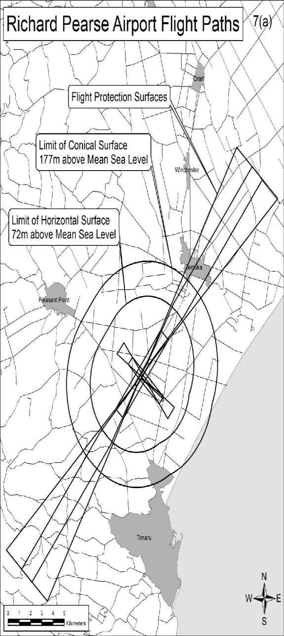
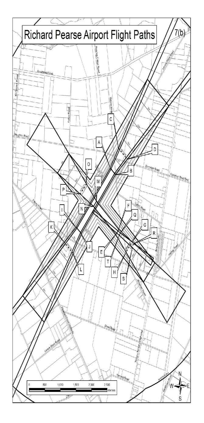
2 (1) The following types of activities are authorised within the boundary of the Airport: Existing and future main and runway extensions, the existing parallel grass, cross wind and glider grass runways; Aircraft operations (jet and turbo prop aircraft over 5700kg, rotary wing aircraft and general aviation fixed wing aircraft under 5700kg) subject to compliance with rule ; Ex-military jet and turbo prop aircraft operations subject to compliance with rule ; Aircraft servicing and engine testing subject to compliance with rule ; Fuel storage together with associated activities including passenger terminals, hangers, internal roading, car and bus parking, navigational aids and lighting; and Ancillary aviation related facilities and uses of buildings likely to include flight training, gliding, caretaker accommodation, and recreational aviation. The purpose of restrictions on the flight paths in and out of the aerodrome is to control other activities in such a way as to ensure the safe and efficient functioning of Richard Pearse (Timaru) Airport. (2) Flight Protection Areas Richard Pearse Airport The use of land or buildings within the flight protection areas specified on the Planning Maps shall be permitted only when the use does not cause a possible hazard to the operation of aircraft from the aerodrome, including any activities attracting large numbers of people or birds, or giving rise to smoke, dust, glare or electrical interference. Within 500 metres of the ends of the future extended main runway and existing cross wind runways and within the area shown on Figure 7(b) no buildings (including glasshouses) shall be erected, and no post and wire structures, other than stock-fences, shall be erected (e.g. for supporting horticulture or viticulture crops). Refer to the table below for the coordinates of points A - T on Figure 7(b).
3 Table showing coordinates of points A - T on Figure 7(b) A B C D E F G H I J K L M N O P Q R S T (3) No building, mast, pole, tree or other object shall penetrate any of the flight paths, side clearances or horizontal and conical surfaces. (4) For details of flight paths, side clearances and horizontal and conical surfaces refer to Figures 7 and 7(b) included with General Rule (5) Flight Paths The flight paths consist of take off and approach corridors in and out of the North South sealed runway and East West grassed runway together with a horizontal surface and a conical surface lying over the aerodrome. (1) Runway Takeoff The takeoff surfaces at each end of the runway commences at the locations and levels shown in table 6.1 and continue out on the runway extended centreline for 15,000 metres.
4 (b) The base width at the origin is 150 metres (75 metres either side of the runway centreline) and the surface rises upwards at a gradient of 1 in 50 and each side expands at a rate of 1 in 8 to a maximum width of 1200 metres and then continues parallel out to a distance of 15,000 metres from the origin. Approach The approach surfaces at each end of the runway commence at the locations and levels shown in table 6.1 and continue out on the runway extended centreline for a distance of 15,000 metres from the origin. (2) Runway The base width at the origin is 220 metres (110 metres wither side of the runway centreline) and the surface rises upwards at a gradient of 1 in 50 and each side expands at a rate of 1 in 6.6 out to a distance of 15,000 metres from the origin. Takeoff and Approach Path (b) The takeoff and approach surfaces at each end of the runway commence at the locations and levels shown in table 6.1 and continue out on the runway extended centreline for 2,500 metres from the origin. The base width at the origin is 150 metres (75 metres either side of runway centreline) and the surface rises upwards at a gradient of 1 in 30 and each side expands at a rate of 1 in 6.6 out to a distance of 2,500 metres from the origin. (3) Glider Grass 10 Takeoff path (b) The takeoff surface at the east end of the runway commences at the location and level shown in table 6.1 and continues out on the runway extended centreline for 1,200 metres from the origin. The west end of the runway is located as shown in table 6.1. The base width at the origin is 60 metres (30 metres either
5 side of runway centreline) and the surface rises upwards at a gradient of 1 in 20 and each side expands at a rate of 1 in 20 out to a distance of 1,200 metres from the origin. (4) Side Clearances The side clearance surface for runway rises at a gradient of 1 in 7 and the side clearance surface for runway at a gradient of 1 in 5, both up to the horizontal surface. The side clearance surfaces originate at the edge of the respective runway strips. (5) Horizontal Surface (b) This surface is located in a horizontal plane which extends over the aerodrome and surrounding land at a height of 45 metres above the runways (elevation 72 metres above MSL). The outer limits of the horizontal surface is measured from the periphery of the strip of runway and a locus of 3,500 metres from the periphery of runway (6) Conical Surface The conical surface slopes upwards and outwards from the periphery of the horizontal surface at a gradient of 1 in 20 up to a height of 150 metres above the runways (elevation 177 metres above MSL). (7) Future Runway Extension (b) Any future development of the aerodrome will consist of lengthening of runway to the north and south by up to 657 metres in total plus 60 metres grassed strip and 90 metres grassed runway end safety area beyond the end of the sealed runway at each end. In order to protect the aerodrome for future runway extensions no permanent structures shall be built under the flight path within the area shown on Figure 7(b). NOTE: For the purposes of this rule the possible runway extension to the north is 262 metres and to the south is 395 metres. (c) See Figure 7(c) for details of proposed runway extension.
6 (8) Table 6.1: Location of takeoff and approach surface bases Surface Runway mn (metres North) me (metres East) Height (Above Mean Sea Level) North Surfaces origin South Surfaces origin Runway m 26.7m East Surfaces origin West Surfaces origin Glider grass m m East Surfaces origin West Surfaces origin m 26.3m All co-ordinates are Timaru circuit coordinates Mt Horrible origin (700,000mN; 300,000mE). Mean Sea Level datum is Lyttelton (1937).
7
8
9
10 PROVISIONS RELATING TO SANITARY LANDFILL - REDRUTH (1) The Redruth site shall be a sanitary landfill operation. Sanitary landfilling is an engineering method of disposing of solid wastes on land in a manner that protects the environment, by spreading the wastes in thin layers, compacting it to the smallest practical volume, and covering it with soil or other suitable cover material by the end of each working day. The operation of the sanitary landfill site shall involve restriction on all access to the landfill face. This will be achieved by the construction and operation of a transfer/reception facility onsite, in conjunction with waste collection by mobile plastic bins. (2) An Operational Management Plan for the site shall be prepared and this Operational Management Plan shall be reviewable every three years. (3) On the extended Redruth site, an environmental buffer zone and protective work shall be developed as follows: (i) (ii) A buffer zone located to the west and north of the site comprising a strip of land up to 120 metres wide but not less than 50 metres wide between the site and the industrial area shall be formed, grassed and planted. An embankment 3 metres to 6 metres in height shall be constructed. Spreading of soil material on the embankment and planting of appropriate grasses and trees and the installation of a watering system shall be undertaken in accordance with the report of the Soil Science Division of Lincoln College. (4) A further environmental buffer zone shall be located to the south and east of the site as the sanitary landfill progresses along this area. This will comprise an embankment and planting to screen the landfill areas from the walkway. (5) Adjacent to the access to the onsite reception area, landscaping and planting shall be undertaken together with suitable planting within road reserves in the immediate vicinity of the main entrance to the sanitary landfill site. (6) Refuse placed in the sanitary landfill shall be compacted using specialised mobile compaction equipment and a minimum area of refuse shall be exposed at any one time. The refuse placed in the sanitary landfill site shall be covered with a nominal 150 millimetres of soil or other cover material on a daily basis.
11 (7) Mesh fences and screens up to 4 metres in height shall be placed around the working areas to prevent windblown material from leaving the immediate vicinity. Regular inspection will be undertaken and any material which is blown beyond the site area will be collected. (8) The final surface of the landfill shall be capped off with a cover of soil material to a depth appropriate to the rehabilitation and landscape programme as set out in the Operational Management Plan. (9) As each section of sanitary landfill is completed, vegetative cover shall be established in accordance with the Operational Management Plan. Rehabilitation will take place on a four to eight year cycle leaving room for managed co-disposal operations. (10) The site shall be operated in a manner designed to avoid the needless attraction of birds or vermin, and control programmes and inspections shall be carried out on a regular basis. (11) The management of the site may include sorting and stock piling of sand, soils and composting of suitable materials primarily for the purpose of regular covering of deposited refuse and topsoiling activities. (12) Co-disposal of special and hazardous wastes shall be in accordance with recognised landfill acceptance criteria or accepted disposal procedures. Special and hazardous wastes may not necessarily be accepted for disposal at the landfill. (13) Leachate shall be collected by an under-drainage system and pumped into the city sewerage system or any alternative leachate disposal systems complying with discharge permits. Stormwater from the working face and the immediate tipping area shall be collected into the leachate collection system. (14) The operating authority shall monitor the sanitary landfill site in respect of the following matters: (i) (ii) (iii) Inspection points will be placed within the site to enable observation of the water table and testing of water quality. A log shall be kept of the special and hazardous wastes codisposed onsite. It shall record the type and amount of material, and the date and location of its disposal within the site. The volume of landfill used per annum shall be recorded as a basis for ensuring the maximum economic life of the site.
12 The above points (i) to (iii) are also requirements of the Canterbury Regional Council Consent CRC (15) No open burning of refuse shall be undertaken at the sanitary landfill site. (16) The Council will encourage the input and comments of any body or person representing some relevant aspect of the public interest to ensure the effective operation of the site in accordance with the provisions of this part of the District Plan and the Operational Management Plan UNDERLYING ZONES The underlying zone of all Designated land shall be the zone in which each respective part of the Designation is located.
PART N PARAPARAUMU AIRPORT
 PART N PARAPARAUMU AIRPORT KAPITI COAST DISTRICT COUNCIL N - 1 DISTRICT PLAN N. PARAPARAUMU AIRPORT Amendment Change 18 20/01/05 N.1. GENERAL Paraparaumu Airport take-off and approach surfaces designation,
RURAL CONSERVATION ZONE
 Chapter 37 RURAL CONSERVATION ZONE INTRODUCTION This Chapter contains rules managing land uses in the. The boundaries of this zone are shown on the Planning Maps. All rules apply throughout the unless
9.3.9 Industry uses code
 9.3.9 Industry uses code 9.3.9.1 Application (1) This code applies to accepted development and assessable development identified as requiring assessment against the Industry uses code by the tables of
This table identifies provisions subject to and consequentially affected by appeals:
 Chapter 17 Airport Zone This table identifies provisions subject to and consequentially affected by appeals: Provision Subject To Appeal (identified in red text in the relevant chapter/s) Consequentially
This Chapter contains rules managing land uses in the Main Rural Zone. The boundaries of this zone are shown on the Planning Maps.
 Chapter 34 MAIN RURAL ZONE RULES INTRODUCTION This Chapter contains rules managing land uses in the. The boundaries of this zone are shown on the Planning Maps. All rules apply throughout the unless otherwise
Motueka Aerodrome. Development Plan. March 2012 REVIEW SCHEDULE. Date Approved. Comments. Issue #
 Motueka Aerodrome Development Plan REVIEW SCHEDULE Issue # 1 2 3 4 5 6 7 Date Approved Comments March 2012 1 P ageof10 Motueka Aerodrome Development Plan. March 2012 1. Role of Development Plan The Development
MAIN INDUSTRIAL ZONE RULES
 Chapter 23 MAIN INDUSTRIAL ZONE RULES Introduction This chapter contains rules managing land uses in the. The boundaries of this zone are shown on the planning maps. All rules apply throughout the unless
FRINGE COMMERCIAL ZONE RULES
 Chapter 17 FRINGE COMMERCIAL ZONE RULES INTRODUCTION This chapter contains rules managing land uses in the. This zone surrounds the CBD area of the City and contains much of the commercial service activity
ARTICLE 6 EXCAVATION OF MINERAL MATERIALS
 ARTICLE 6 EXCAVATION OF MINERAL MATERIALS SECTION 1. PURPOSE All excavations, extraction of materials and minerals, open pits and impounding of waters hereafter established or enlarged shall conform to
SECTION SITE PREPARATION. A. PART A and DIVISION 1 of PART B are hereby made a part of this SECTION.
 SECTION 311000 PART 1 GENERAL 1.01 GENERAL REQUIREMENTS A. PART A and DIVISION 1 of PART B are hereby made a part of this SECTION. B. Examine all conditions as they exist at the project prior to submitting
Permeability across the entire site within the General Residential Zone is a minimum of 30%.
 Partly Operative District Plan Rule Assessment The following assessment is to demonstrate compliance or non-compliance with the rules of the Partly Operative District Plan. The proposed duplex dwellings,
SUBURBAN COMMERCIAL ZONE - RULES
 Suburban Commercial Zone Chapter 18 SUBURBAN COMMERCIAL ZONE - RULES INTRODUCTION This chapter contains rules managing land uses that take place within the suburban shopping centres of the City. This includes
CHAPTER MUNICIPAL AIRPORT ZONE
 CITY OF MOSES LAKE MUNICIPAL CODE Sections: 18.35.010 Purpose 18.35.020 Permitted Uses 18.35.030 Conditional Uses 18.35.040 Prohibited Uses 18.35.050 Development Standards 18.35.060 Violation CHAPTER 18.35
17. Works and Network Utilities
 17. Works and Network Utilities Explanatory Statement Works and network utilities are essential features of the District's infrastructure. Kaimai Hydro Power generates 30 percent of the District's electricity
APPLICATION FOR CHANGE OR CANCELLATION OF RESOURCE CONSENT CONDTION
 APPLICATION FOR CHANGE OR CANCELLATION OF RESOURCE CONSENT CONDTION (Section 127 of the Resource Management Act 1991) Use this form to apply to the Waitaki District Council for a change/variation or cancellation
SECTION 7: INDUSTRIAL ZONE RULES
 SECTION 7: INDUSTRIAL ZONE RULES 7.1 CATEGORIES OF ACTIVITIES 7.1.1 PERMITTED ACTIVITIES The following activities are permitted activities in the Industrial Zone, provided activities comply with all relevant
3 RURAL ENVIRONMENT CONTENTS
 3 RURAL ENVIRONMENT CONTENTS 3.1 ISSUES 4 3.2 OBJECTIVES 5 3.3 POLICIES 7 3.4 RULES RURAL PRODUCTION ZONE 10 3.5 Performance standards 15 3.6 RULES RURAL LIFESTYLE ZONE 18 3.7 Performance standards 19
MAIN RESIDENTIAL ZONE RULES
 Chapter 5 MAIN RESIDENTIAL ZONE RULES Introduction This chapter contains rules managing land uses in the. boundaries of this zone are shown on the planning maps. The All rules apply throughout the unless
subdivision WORKING ENVIRONMENT AND COMMUNITY ENVIRONMENT RULES ASSESSMENT CRITERIA
 Character, Mauri, Amenity Values, Neighbourhood Character, Health & Safety and Heritage RULES ASSESSMENT CRITERIA 5.0 General The following rules shall apply to the of land situated in the Community Environment
MIXED ACTIVITY ZONE. Chapter 4. Mixed Activity Zone
 Chapter 4 Mixed Activity Zone 4. MIXED ACTIVITY ZONE 4.1 RESOURCE MANAGEMENT ISSUES 1. Activities adjoining main arterial roads can adversely affect the safety, sustainability and efficiency of the network.
PART 5D - NATURAL HAZARDS
 CONTENTS...PAGE 5D.1 CONTENT AND STRUCTURE...3 5D.2 RESOURCE MANAGEMENT ISSUES...3 5D.3 RESOURCE MANAGEMENT OBJECTIVE AND POLICIES...4 5D.4 RESOURCE MANAGEMENT STRATEGY...4 5D.5 IMPLEMENTATION...4 5D.6.RULES
CHAPTER A (AIRPORT OVERLAY) DISTRICTS
 DISTRICTS") CHAPTER 19.12 A (AIRPORT OVERLAY) DISTRICTS Section Page 19.12.010 Purpose... II-198 19.12.020 Definitions... II-198 19.12.030 Airport Districts... II-200 19.12.040 Airport Provisions... II-200 19.12.050
CHAPTER 19.12 A (AIRPORT OVERLAY) DISTRICTS Section Page 19.12.010 Purpose... II-198 19.12.020 Definitions... II-198 19.12.030 Airport Districts... II-200 19.12.040 Airport Provisions... II-200 19.12.050
General A. General A.1 Activities Not Specifically Provided For A.2 Temporary Activities... 3
 Section Contents General... 2 4A. General... 2 4A.1 Activities Not Specifically Provided For... 2 4A.2 Temporary Activities... 3 4A.3 Activities on the Surface of Water... 6 4A.4 Status of Roads... 7 4A.5
The difficulties Maori can experience in expressing their cultural relationship with ancestral lands.
 OVERVIEW The Papakaianga Zone provides particular recognition and provision for the relationship of tangata whenua of Banks Peninsula with their ancestral lands. The term Papakaianga can mean original
30A RULES FOR RENEWABLE ENERGY GENERATION
 30A RULES FOR RENEWABLE ENERGY GENERATION Policies 16A.4.1 Activities Tables 30A.1 Subdivision Activities Activity Status The operation and maintenance of existing renewable energy generation facilities
subdivision INFILL SUBDIVISION ASSESSMENT CRITERIA RULES
 Safety and Heritage RULES 3.0 General The following rules shall apply to the of land situated in the Living Environment where the is of existing sites either up to 1ha in net site area or which creates
Part 8 Natural hazards
 Part 8 Natural hazards Contents Page 8.1 Introduction... 3 8.2 Resource management issue... 3 8.3 Objectives and policies... 3 8.4 Resource management strategy... 5 8.5 Rules - restricted discretionary
Appendix S10 - Airport Business Zone Structure Plan
 S10.1 S10.1.1 S10.1.2 General The Airport Business Zone Structure Plan covers an area of some 157ha surrounding the airport operational area. It contains some existing industrial and service activities
Division 13 Temporary Use Code
 Division 13 Temporary Use Code 12.13.1 Temporary Use Code (1) The provisions in this division comprise the Temporary Use Code. (2) They are compliance with the Temporary Use Code (section 12.13.2); overall
ULDA Decision Notice
 ULDA Decision Notice Site Address Bowen St, Roma Real property description Lot 142 SP250497 Type of approval UDA development approval subject to conditions Aspects of development Reconfiguring a Lot with
Auckland Unitary Plan Operative in part 1
 Designation Schedule - New Zealand Refining Company Number Purpose 6500 Operation, maintenance and repair, upgrade and renewal of the existing petroleum transmission pipeline and ancillary facilities...
22.1 ISSUES OBJECTIVES POLICIES RULES PERFORMANCE STANDARDS 10
 22 NETWORK UTILITIES 22.1 ISSUES 3 22.2 OBJECTIVES 4 22.3 POLICIES 4 22.4 RULES 6 22.5 PERFORMANCE STANDARDS 10 Whanganui District Plan (15 January 2018) Chapter 22 Network Utilities 22-1 22 NETWORK UTILITIES
IDAS form 6 Building or operational work assessable against a planning scheme
 IDAS form 6 Building or operational work assessable against a planning scheme (Sustainable Planning Act 2009 version 2.0 effective 17 December 2012) This form must be used for development applications
APPLICATION FOR LANDUSE RESOURCE CONSENT
 (Section 88 of the Resource Management Act 1991) Form 9 APPLICATION FOR LANDUSE RESOURCE CONSENT I,.. (full name) being the applicant residing at the below address, apply to the Waitaki District Council
THE FONDCOLE SANITARY LANDFILL
 DOMINICA SOLID WASTE MANAGEMENT CORPORATION THE FONDCOLE SANITARY LANDFILL BYEN VINI.WELCOME. Description of Site The Fond Cole Sanitary Landfill is located in Fond Cole, one (1) mile north of Roseau.
Regulation 18 August 2009 NO Operations and Maintenance LEVEE ENCROACHMENT STANDARDS AND PROCEDURES
 CENWP-EC DEPARTMENT OF THE ARMY PDR 30-2-5 Portland District, Corps of Engineers (Draft) P.O. Box 2946 Portland, Oregon 97208 Regulation 8 August 2009 NO. 30-2-5 Operations and Maintenance LEVEE ENCROACHMENT
Section 1 OBC FADS /13 Access to Parking Areas
 Section 1 OBC 3.8.2.2 4.3.12/13 Access to Parking Areas A barrier-free path of travel is provided from: a) the entrance to the exterior parking area b) at least one parking level where a passenger elevator
WASTEWATER DRAINAGE BYLAW
 WASTEWATER DRAINAGE BYLAW 2018 Pursuant to Section 145 of the Local Government Act 2002 and every other enabling power and authority. To come into force: 1 July 2018 For the purpose of: a) Controlling
20.2 Issue 1 - Protecting the amenity within Business Zones and in areas adjoining Business Zones.
 20. Business Zones 20.1 Introduction Kaikoura township is the principal commercial and service centre of the District, containing a wide range of retail outlets, offices, mixed industry, travellers accommodation,
Management Plan: Hazardous Materials Removal & Demolition
 Management Plan: Hazardous Materials Removal & Demolition Kingswood School (Upper Site), Corby 1.0 Introduction 1.1 Background Lambert Smith Hampton has been instructed by Northamptonshire County Council
E36. Natural hazards and flooding
 E36. Natural hazards and flooding E36.1. Background Auckland is affected by natural hazards including: those that occur frequently such as flooding, coastal erosion (including the effects of sea level
S e c t i o n B i o d i ve r s i t y
 S e c t i o n 2. 2 - B i o d i ve r s i t y The District has a wealth of ecosystems which support indigenous vegetation and habitats of indigenous fauna. Many of these ecosystems are the remnants of the
Chapter 7 Transport. Appendix A to Legal Submissions. Council's Revised Stage 2 Proposal (marked up) 1 September 2015 version
 1 September 2015 version") Chapter 7 Transport Key: In this Revised Proposal Appendix A to Legal Submissions Stage 1 provisions are shown in grey text; and Stage 2 provisions are shown in black text. The Stage 1 text is as per the
Chapter 7 Transport Key: In this Revised Proposal Appendix A to Legal Submissions Stage 1 provisions are shown in grey text; and Stage 2 provisions are shown in black text. The Stage 1 text is as per the
Auckland Council District Plan (Papakura Section) Contents of Section Two
 Contents of Section Two") Auckland Council District Plan (Papakura Section) Contents of Section Two CONTENTS OF SECTION TWO, PART 2 - RURAL PAPAKURA 1.0 INTRODUCTION... 2/1-18 1.1 Activity Table... 2/2 1.2 General Assessment Criteria...
Auckland Council District Plan (Papakura Section) Contents of Section Two CONTENTS OF SECTION TWO, PART 2 - RURAL PAPAKURA 1.0 INTRODUCTION... 2/1-18 1.1 Activity Table... 2/2 1.2 General Assessment Criteria...
ANNEXURE 3 ASSESSMENT OF ENVIRONMENTAL EFFECTS
 ANNEXURE 3 ASSESSMENT OF ENVIRONMENTAL EFFECTS 3.1 INTRODUCTION 3.1.1 The following is a summary of the actual or potential environmental effects that are likely to arise from the expansion of the Aerodrome:
(1 February to date) ENVIRONMENT CONSERVATION ACT 73 OF (Gazette No , Notice No Commencement date: 9 June 1989)
 ENVIRONMENT CONSERVATION ACT 73 OF (Gazette No , Notice No Commencement date: 9 June 1989)") (1 February 2002 - to date) ENVIRONMENT CONSERVATION ACT 73 OF 1989 (Gazette No. 11927, Notice No. 1188. Commencement date: 9 June 1989) DIRECTIONS IN TERMS OF SECTION 20(5) OF THE ENVIRONMENT CONSERVATION
(1 February 2002 - to date) ENVIRONMENT CONSERVATION ACT 73 OF 1989 (Gazette No. 11927, Notice No. 1188. Commencement date: 9 June 1989) DIRECTIONS IN TERMS OF SECTION 20(5) OF THE ENVIRONMENT CONSERVATION
URBAN SETTLEMENT ZONE - RULES
 URBAN SETTLEMENT ZONE - RULES.1 Rule Statement The following rules, shall apply to all land shown as being within the Urban Settlement Zone in the District Plan Maps. These rules shall be read in conjunction
5.8 LOW DENSITY RESIDENTIAL ZONE
 5.8 LOW DENSITY RESIDENTIAL ZONE 5.8.1 ZONE PURPOSE (1) Low density residential development areas are designed to satisfy a particular demand from people wishing to live in a semi-rural setting, but to
Business and Industrial Areas Queenstown, Frankton, Arrowtown and Wanaka 11.1 Issues, Objectives and Policies
 . Business and Industrial Areas Queenstown, Frankton, Arrowtown and Wanaka.1 Issues, Objectives and.1.1 Resources, Activities and Values Business activities occur throughout the commercial, service and
Network utilities, subject to compliance with Part 6 (Infrastructure) A.3 Existing vegetation cover.
 A.3 Existing vegetation cover.") 5.3.2. Rural Zone 5.3.2.1. Permitted Activities 5.3.2.1.1. Residential, recreational, agricultural, exotic forestry or tourist related activities which comply with the standards for permitted activities
5.3.2. Rural Zone 5.3.2.1. Permitted Activities 5.3.2.1.1. Residential, recreational, agricultural, exotic forestry or tourist related activities which comply with the standards for permitted activities
City of Brandon Division 2 Standard Construction Specifications Section January 2007(Revision 1) Page 1 of 8 ROADWAY EXCAVATION AND GRADING
 Page 1 of 8 ROADWAY EXCAVATION AND GRADING") January 2007(Revision 1) Page 1 of 8 PART 1 GENERAL 1.01 OTHER CONTRACT DOCUMENTS 1.02 DESCRIPTION OF WORK 1.03 RELATED WORK 1.04 CLASSIFICATION OF THE WORK 1.05 QUALITY ASSURANCE PART 2 PRODUCTS 2.01
January 2007(Revision 1) Page 1 of 8 PART 1 GENERAL 1.01 OTHER CONTRACT DOCUMENTS 1.02 DESCRIPTION OF WORK 1.03 RELATED WORK 1.04 CLASSIFICATION OF THE WORK 1.05 QUALITY ASSURANCE PART 2 PRODUCTS 2.01
Operative Ashburton District Plan
 Operative Ashburton District Plan Rural B Zone Map R62 Designations D53 and D65 RDR and MHIS infrastructure A49 Lower Rangitata River identified as site of Significant Nature Conservation Value G21 Geoconservation
E36. Natural hazards and flooding
 E36. Natural hazards and flooding E36.1. Background Auckland is affected by natural hazards including: those that occur frequently such as flooding, coastal erosion (including the effects of sea level
NORTHERN RESIDENTIAL ZONE
 Chapter 7 NORTHERN RESIDENTIAL ZONE INTRODUCTION This chapter contains rules managing land uses in the. boundaries of this zone are shown on the planning maps. The All rules apply throughout the unless
Palmerston North City Council District Plan May 2018 NETWORK UTILITIES Introduction Resource Management Issues 2
 SECTION 23: NETWORK UTILITIES CONTENTS 23.1 Introduction 1 23.2 Resource Management Issues 2 23.3 Objectives and Policies 3 23.4 Methods 6 23.5 Rules: Note for Users 6 23.6 Rules: Permitted Activities
West Mead Township Crawford County, Pennsylvania Ordinance No
 West Mead Township Crawford County, Pennsylvania Ordinance No. 2001-4 ORDINANCE TO AMEND THE WEST MEAD TOWNSHIP ZONING ORDINANCE TO ADD LAND USE REGULATIONS FOR COMMUNICATIONS TOWERS Whereas, the Board
DRAINAGE REPAIR POLICY FOR COUNTY DRAINAGE SYSTEMS. Drainage System No.
 DRAINAGE REPAIR POLICY FOR COUNTY DRAINAGE SYSTEMS Drainage System No. The following policy is intended to supplement Minnesota Statutes Chapter 103E in the Maintenance and Operation of Drainage Systems
Chapter 17.6 Airport Activities Page 1
 Chapter 17.6 Airport Activities Page 1 Chapter 17.6 Airport Activities 17.6.1 Introduction The Auckland International Airport ( Airport ) is situated in Mangere on the shores of the Manukau Harbour. The
S e c t i o n S u b d i vision
 S e c t i o n 2. 6 - S u b d i vision Subdivision is a process of defining and redefining land parcel boundaries and can provide a framework for future land use and development. Integrated, well planned
GUIDELINES ON THE MANAGEMENT OF WASTE DISPOSAL SITE (LANDFILL)
") 1 REPUBLIC OF RWANDA RWANDA UTILITIES REGULATORY AGENCY P.O BOX 7289 KIGALI, Tel: +250 252 584562, Fax: +250 252 584563 Email: arms@rwanda1.com Website: www.rura.gov.rw GUIDELINES ON THE MANAGEMENT OF
1 REPUBLIC OF RWANDA RWANDA UTILITIES REGULATORY AGENCY P.O BOX 7289 KIGALI, Tel: +250 252 584562, Fax: +250 252 584563 Email: arms@rwanda1.com Website: www.rura.gov.rw GUIDELINES ON THE MANAGEMENT OF
The HKIE Structural Examination Written Examination
 The HKIE Structural Examination Written Examination Section 2: Design Questions (80% of the Written Examination) Date: 28 November 2014 (Friday) Time: 12:00 nn - 06:00 pm Answer ONE question only Question
Section 51 Light Industrial Zone
 Section 51 Light Industrial Zone 51.1 ZONE DESCRIPTION The Light Industrial Zone is located outside and within the settlements of Pauanui, Tairua, Coromandel, Thames, Whangamata and Matarangi. The Zone
Single Family Residential Construction Erosion/Sediment Control Standards
 Single Family Residential Construction Erosion/Sediment Control Standards Introduction: This booklet contains standard plans and procedures sufficient for typical building construction. It is not intended
"INOGATE Technical Secretariat & Integrated Programme in support of the Baku Initiative and the Eastern Partnership energy objectives" Project
 "INOGATE Technical Secretariat & Integrated Programme in support of the Baku Initiative and the Eastern Partnership energy objectives" Project B U I L D I N G P A R T N E R S H I P S F O R E N E R G Y
STANDARD GRADING AND SOIL EROSION & SEDIMENT CONTROL PLAN FOR SINGLE LOT SINGLE FAMILY RESIDENTIAL CONSTRUCTION AND MINOR EARTH DISTURBANCES
 DIVISION OF ENGINEERING & CONSTRUCTION MANAGEMENT PLAN REVIEW DEPARTMENT WASHINGTON COUNTY SOIL CONSERVATION DISTRICT 1260 Maryland Avenue, Suite 101 Hagerstown, MD 21740 Telephone: (301) 797-6821, Ext.
Erosion & Sedimentation Control Policy
 Issue Date 10/22/2010 Page 1 of 8 Erosion & Sedimentation Control Policy Introduction: Soil erosion is the removal of soil by water, wind, ice or gravity and sediment deposition occurs when the rate of
Stormwater Erosion Control & Post-Construction Plans (Stormwater Quality Plans)
") Stormwater Erosion Control & Post-Construction Plans (Stormwater Quality Plans) Allen County Stormwater Plan Submittal Checklist The following items must be provided when applying for an Allen County Stormwater
Stormwater Erosion Control & Post-Construction Plans (Stormwater Quality Plans) Allen County Stormwater Plan Submittal Checklist The following items must be provided when applying for an Allen County Stormwater
Section 10 - Airport Business Zone (Titanium Park)
") 10.1 Introduction 10.1.1 The Hamilton International Airport (the Airport) is a facility of economic and social importance to the Waikato Region. The Airport Business Zone associated with it (Titanium Park)
10.1 Introduction 10.1.1 The Hamilton International Airport (the Airport) is a facility of economic and social importance to the Waikato Region. The Airport Business Zone associated with it (Titanium Park)
IDAS form 6 Building or operational work assessable against a planning scheme
 (Sustainable Planning Act 2009 version 3.0 effective 1 July 2013) This form must be used for development applications for building work or operational work assessable against a planning scheme. You MUST
The remainder of Area C is restricted to 120,535 square feet of office use; and an 894 bed detention facility.
 Page 1 of 18 STAFF REPORT Rowan Replat 013-UP-91 A request to amend the note on the plat has been filed with the Planning and Development Management Division. This plat was approved by the Broward County
Beaumont Lot Grading Guidelines
 Beaumont Lot Grading Guidelines Updated: 2019-01-14 CONTENTS LOT GRADING OVERVIEW... 3 INTRODUCTION... 3 PURPOSE... 3 DEFINITIONS... 3 LOT GRADING REQUIREMENTS... 3 DESIGN GRADES AND EXISTING GRADES...
Minimum Standards for Construction of Aircraft Hangars MINIMUM STANDARDS FOR CONSTRUCTION OF AIRCRAFT HANGARS
 Minimum Standards for Construction of Aircraft Hangars ARTICLE 1. MINIMUM STANDARDS FOR CONSTRUCTION OF AIRCRAFT HANGARS Section 1. - Purpose Section 2. - Goals Section 3. General Provisions Section 4.
LOT GRADING GUIDELINES FOR COMMERCIAL, INDUSTRIAL, INSTITUTIONAL, MEDIUM AND HIGH DENSITY RESIDENTIAL PROPERTIES
 LOT GRADING GUIDELINES FOR COMMERCIAL, INDUSTRIAL, INSTITUTIONAL, MEDIUM AND HIGH DENSITY RESIDENTIAL PROPERTIES Contents COMMERCIAL, INDUSTRIAL, INSTITUTIONAL, MEDIUM AND HIGH DENSITY... 1 RESIDENTIAL
E36. Natural hazards and flooding
 E36. Natural hazards and flooding E36.1. Background Auckland is affected by natural hazards including: those that occur frequently such as flooding, coastal erosion (including the effects of sea level
TOOELE COUNTY LAND USE ORDINANCE CHAPTER 26 Page 1
 CHAPTER 26 CONSTRUCTION DEBRIS AND MUNICIPAL SOLID WASTE ZONES Part 26-1. General. 26-2. Construction debris overlay zone (CDO). 26-3. Municipal solid waste zone (MSW). 26-4. Use tables. Part 1 General
City of Valdosta Land Development Regulations
 Chapter 324 Section 324-1 Environmental Planning Criteria Protection of Groundwater Recharge Areas (A) Purpose and Intent. Pursuant to O.C.G.A. 12-2-8 and the Georgia Department of Natural Resources (DNR),
South Landfill Annual Cover Rate Screening Criteria Checklist
 South Landfill Annual Cover Rate Screening Criteria Checklist The following checklist is taken from the Guide to Environmental Assessments for Waste Management Projects, Part B Environmental Screening
Nonmetallic Mining Reclamation & Operation Plan. Amendment No. 1 (Includes modifications for Wash Plant construction) DRAFT
 DRAFT") Nonmetallic Mining Reclamation & Operation Plan Amendment No. 1 (Includes modifications for Wash Plant construction) Mondovi Mine Town of Mondovi, Wisconsin Prepared for: Buffalo White Sand, LLC PO Box
Nonmetallic Mining Reclamation & Operation Plan Amendment No. 1 (Includes modifications for Wash Plant construction) Mondovi Mine Town of Mondovi, Wisconsin Prepared for: Buffalo White Sand, LLC PO Box
7.00 INTRODUCTION... 1
 SITE PLANS, REZONING, LAND DIVISION AND CONDOMINIUM SECTION 7 GENERAL REQUIREMENTS INDEX Page 7.00 INTRODUCTION... 1 7.01 SITE GRADING AND MECHANICAL PLANS... 2 7.01.01 Submission Procedures... 2 7.01.02
GRADING, EROSION AND SEDIMENTATION CONTROL
 SECTION 500 GRADING, EROSION AND SEDIMENTATION CONTROL 501 Erosion and Sedimentation Control Plan All engineering plans for projects that propose to construct new, or modify existing drainage facilities,
Cass County Soil Erosion & Sedimentation Control Program
 Cass County Soil Erosion & Sedimentation Control Program Both residents and visitors of Cass County enjoy the beauty of over 250 lakes and ponds, along with numerous streams, creeks, and wetlands that
Tabulated overview of the obligation to submit the use and occupancy notice or building design documentation and to apply for use and occupancy permit
 Tabulated overview of the obligation to submit the use and occupancy or building and to apply for use and occupancy Building Code Annex 2 Building Activity Erection Construction Remodelling Expansion by
NTW.1 Network Utilities
 NTW.1 Network Utilities NOTE: The following provisions apply district wide in addition to any other provisions in this Plan applicable to the same areas or site. Index NTW.1 Network Utilities NTW.1.1 NTW.1.2
Arboricultural Assessment
 1 Arboricultural Assessment Site Address: Prepared for: Purpose of Report: 285G Manawaora Road, Russell Owen Burn Green Group cc: Peter Thornton Assessment of the Proposed Jetty Construction, Waipohutukawa
5.9 MARAE DEVELOPMENT ZONE
 5.9 MARAE DEVELOPMENT ZONE 5.9.1 ZONE PURPOSE (1) The provision of a specific zone in which Maori people can undertake ongoing development of their culture, traditions and social infrastructure, is one
CITY OF SAFETY HARBOR 750 MAIN STREET, SAFETY HARBOR, FLORIDA PHONE: 727/ FAX: 727/
 CITY OF SAFETY HARBOR 750 MAIN STREET, SAFETY HARBOR, FLORIDA 34695 PHONE: 727/724-1555 FAX: 727/724-1566 RIGHT-OF-WAY / EASEMENT USE PERMIT DATE SUBMITTED: EXPIRATION DATE: Submit the following to the
LAND USE PBF LDR ZONING PUD PUD. Proposed Maximum Density (DU/Acre) Existing Maximum Intensity (FAR) .30 FAR/ 173 dwelling units.
 Existing Maximum Intensity (FAR) .30 FAR/ 173 dwelling units.") PROPOSED LARGE SCALE FUTURE LAND USE MAP (FLUM) AMENDMENT OVERVIEW ORDINANCE: 2013-658 APPLICATION: 2013G-001-3-5 APPLICANT: PAUL HARDEN PROPERTY LOCATION: On the south side of Sunbeam Road, at the terminus
PROPOSED LARGE SCALE FUTURE LAND USE MAP (FLUM) AMENDMENT OVERVIEW ORDINANCE: 2013-658 APPLICATION: 2013G-001-3-5 APPLICANT: PAUL HARDEN PROPERTY LOCATION: On the south side of Sunbeam Road, at the terminus
MINNEHAHA CREEK WATERSHED DISTRICT BOARD OF MANAGERS REVISIONS PURSUANT TO MINNESOTA STATUTES 103D.341. Adopted April 24, 2014 Effective June 6, 2014
 MINNEHAHA CREEK WATERSHED DISTRICT BOARD OF MANAGERS REVISIONS PURSUANT TO MINNESOTA STATUTES 103D.341 Adopted April 24, 2014 Effective June 6, 2014 EROSION CONTROL RULE 1. POLICY. It is the policy of
Page 1 of 1 General Waste Management Guideline
 May 2013 General waste at Adelaide and Parafield Airports is mixed waste comprised of anything that is no longer required and discarded of in a bin. This includes food waste (e.g. organic), beverage containers,
Cass County Soil Erosion & Sedimentation Control Program
 Cass County Soil Erosion & Sedimentation Control Program Both residents and visitors of Cass County enjoy the beauty of over 250 lakes and ponds, along with numerous streams, creeks, and wetlands that
RESERVE MANAGEMENT PLAN GLENORCHY AIRSTRIP
 RESERVE MANAGEMENT PLAN GLENORCHY AIRSTRIP TABLE OF CONTENTS Executive Summary 1 Introduction 2 Site Description 2 Description of Reserve and Activities 2 Management of Reserve 3 Runway and Operational
4 RESIDENTIAL ENVIRONMENT
 4 RESIDENTIAL ENVIRONMENT 4.1 ISSUES 2 4.2 OBJECTIVES 3 4.3 POLICIES 4 4.4 RULES - Residential Zone 7 4.5 PERFORMANCE STANDARDS 10 4.6 RULES Coastal Residential Zone 17 4.7 PERFORMANCE STANDARDS 22 Whanganui
OUTLINE SPECIFICATION ALL-WEATHER PLAYING PITCHES
 OUTLINE SPECIFICATION FOR THE CONSTRUCTION OF ALL-WEATHER PLAYING PITCHES AT PORTARLINGTON SWIMMING POOL AND LEISURE CENTRE PEOPLES PARK, LINK ROAD, PORTARLINGTON, CO. LAOIS Date: July, 2011. INTRODUCTION
Rural-Residential Rural-Residential Explanatory Statement Significant Issues Objectives and Policies...
 Section Contents Rural-Residential... 2 16. Rural-Residential... 2 Explanatory Statement... 2 16.1 Significant Issues... 2 16.2 Objectives and Policies... 3 16.3 Activity Lists... 3 16.4 Activity Performance
GRADING, FILL, EXCAVATION AND LANDSCAPING 2012 EDITION
 CHAPTER 23.105 GRADING, FILL, EXCAVATION AND LANDSCAPING 2012 EDITION Sections 23.105.101 General... 1 23.105.102 Definitions... 1 23.105.103 Permits required... 3 23.105.104 Hazards.... 4 23.105.105 Permit
2 EARTHWORKS AND GEOTECHNICAL REQUIREMENTS
 Section 2 Earthworks and Geotechnical Requirements 2 EARTHWORKS AND GEOTECHNICAL REQUIREMENTS CONTENTS 2 EARTHWORKS AND GEOTECHNICAL REQUIREMENTS... I 2.1 Introduction... 2-1 2.1.1 Objectives... 2-1 2.1.2
Pahiatua Waste Water Treatment Plant Wetland Erosion and Sediment Control Plan (ESCP)
") Tararua District Council Pahiatua Waste Water Treatment Plant Wetland Erosion and Sediment Control Plan (ESCP) NOTE: This is a draft ESCP in current preparation. Additional and updated information will
Tararua District Council Pahiatua Waste Water Treatment Plant Wetland Erosion and Sediment Control Plan (ESCP) NOTE: This is a draft ESCP in current preparation. Additional and updated information will
CHAPTER 725. Solar Farms.
 CHAPTER 725 Solar Farms. The following provisions shall apply to all solar farms in Carroll County, IL. A Solar Farm is defined as a power station using photovoltaic modules and inverters for utility electricity
GRADING & DRAINAGE PERMIT SOIL EROSION AND SEDIMENTATION CONTROL PERMIT PROGRAM OVERVIEW
 GRADING & DRAINAGE PERMIT SOIL EROSION AND SEDIMENTATION CONTROL PERMIT PROGRAM OVERVIEW Chapter 8 Building and Building Regulations, Article XIII Grading and Drainage and Article XV Soil Erosion and Sedimentation