Patrick Nimiago Forest Research Institute,Lae
|
|
|
- Zoe Williams
- 5 years ago
- Views:
Transcription


1 Patrick Nimiago Forest Research Institute,Lae

2 PRESENTATION CONTENT 1. Why soil survey Is 2. soil What to a survey living and measure or non living thing? 3. Where to sample soil 4. Timing of sample 5. Sampling techniques 6. Depth of soil sapling 7. Number of soil samples 8. Handling of samples 9. Laboratory work 10. Interpretation of results 11. Discussion Points

3 PROCESS OF SOIL FORMATION Generally accepted that five interacting factors influence soil formation Physical Weathering Chemical Weathering Soil Formation Base Rock 1. Climate Fragment sand 5. Time C Charge ingredients /organics. Inorganics R A 1. Mineral particles Worms, Collembolon Decomposing 2. Organic C materials organics, Re-synthesising organics 3. Water Ingredients concentrated 4. Air R Humus formation. 5. Living L Organisms Chemical ingredient F-H Develop the soil horizon accumulation A and soil structure Soil R (mother rock) 2. Organisms 3. Relief (Topography) 4. Parent material B C R Variance of Heat/Water, Swell/Shrinkage, Freezing/Melting Crack, break, Moss and Licken grow Soil is defined Charge as ingredient/ thin unconsolidated Si, Al,Fe, material covering surface Ca, Mg, K, of Mn, earth. Cu, C, N, P, H, O Main constituents of soil Soils are heterogeneous and changes in space and time Progress of soil maturation


4 Soil horizons Soil layers are called horizons, and are defined by differences in color and/or texture and/or structure O, A, B, C system used to name horizons; O horizons organic-rich, surface layers A horizons - surface/near-surface layers B horizons - subsurface layers C horizons - parent material layers Soil profiles Soil profiles consists of different combinations of O, A and B horizons The A horizons represent the greatest store of organic carbon in the soil profile, even though the B horizons are generally much deeper and more clayey Thick O horizons are most common in cool, moist environments
 Histosols Cambisols Histosols Lithosols Luvisols Gleysols Cambisols Lithosols Fluvisols Acrisols Andosols Acrisols Luvisols Regosols Luvisols Andosols Gleysols Cambisols")
5 Broad Soil Groups (Orders by FAO Classification) High Mountains (All Montane Forests) Low Mountains and Hills (Low Altitude Forests- Uplands) Plains and Valleys (Low Altitude Forests Plains and Fans) Histosols Cambisols Histosols Lithosols Luvisols Gleysols Cambisols Lithosols Fluvisols Acrisols Andosols Acrisols Luvisols Regosols Luvisols Andosols Gleysols Cambisols Acrisols
6 Soil survey for assessing carbon and other nutrients Soils of PNG stores a lot of organic carbon 1. Methodology How soil carbon is assessed Cheaper measurement Outputs useful in models Makes sense to the end-user 2. Preliminary results-comparable results Contributes to Usefulness for policy Agriculture SFM Climate change
7 Stratifying for soil types, soil organic carbon (SOC) management types SOC of mineral forest soils (0-1 m) varies between 20 and 300 t ha-1, depending on forest type and climatic condition. 50% SOC within upper 30 cm of the soil profiles. In forest soils the highest input from above-ground litter, soil organic matter tends to concentrate in the upper soil horizons. Carbon held in the upper profile is often the most chemically decomposable, and the most directly exposed to natural and anthropogenic disturbances. Soil is a sink for carbon Different origins (vegetative sources) Transformations (pyrolysis, decomposition, symbionts) Different forms (chemical, physical, protected
8 SOIL CARBON OTHER PNG SITES Site Characteristics Soil carbon (t/ha to 1 m) Reference Oomsis-1 Lowland, schist, upper slope 86 Matsuura 1997 Oomsis-2 Lowland, schist, lower slope 132 Matsuura 1997 Buang 1400 m, schist upper slope, 97 Matsuura 1997 Madang-Kumil Lowland, sedimentary, upper slope 123 Matsuura 1997 Madang-Kumil Lowland, sedimentary, lower slope 95 Matsuura 1997 Mongi-Busiga Lowland primary forest, limestone, 34 o 157 Abe slope, slight erosion Mongi-Busiga Lowland primary forest, limestone, 17 o 101 Abe slope, no erosion Mongi-Busiga 9722 Lowland primary forest, limestone, 17 o slope, slight erosion 112 Abe 2007 Mongi-Busiga 9720 Lowland primary forest, limestone, 13 o slope, slight erosion 134 Abe 2007

9 Detail soil carbon sampling sites by FRI Plot and Location Altitude (m) asl Forest Type Management Kui Morobe Province 2-20 Danar Coastal lowland Logged before 1990 Watut 3 - Morobe Province 2170 Montane Logged in 1995 Watut 7-Morobe Province 2190 Montane closed Intact unlogged Danar 1- Madang Province 140 Lowland Shifting secondary cultivation Danar 3 -Madang Province 152 Lowland Logged in 2006 Watut Kui Busiga
 by soil layer 11 11.29 (5.60) 5 cm 10cm 20cm 30cm 8.70 13.12 12.12 (3.21) (3.50) (8.10) Total 45.22 (11.28) Danar 1 2170 Logged in 1995 12 12.79 (2.85) 10.02 (2.")
10 Indicative figures of C SOC from from selected FRI FRI PSPs PSPs Mean total soil carbon stock with standard deviations in the parenthesis Site Altitude (m) asl Management Type Kui 2-20 Logged before 1990 Sample No Carbon stock (t/ha) by soil layer (5.60) 5 cm 10cm 20cm 30cm (3.21) (3.50) (8.10) Total (11.28) Danar Logged in (2.85) (2.05) (4.56) (3.91) (5.56) Danar Intact unlogged (3.77) 7.19 (2.77) 6.67 (3.69) 4.65 (1.16) (8.55) Watut Shifting cultivation (4.17) (3.95) (11.20) (7.50) (21.38) Watut Logged in (6.12) (6.88) (7.82) (9.36) (22.78)
 Total C (%) Watut West 1102 A 0-4 14.8 B 1 4-12 11.6 B 2 12-60 5.73 Watut West 1101 AB 0-21 13.6 B 1 21-56 6.99 14.8 11.6 13.6 5.73 6.")
11 Some examples of carbon content from profile surveys in high altitude Soil Profile Code Horizon Depth (cm) Total C (%) Soil Profile Code Horizon Depth (cm) Total C (%) Watut West 1102 A B B Watut West 1101 AB B
 Total C (%) Wasapea 0702 A1 0-5 3.")
 Total C (%) Gogoroba 0704 A0 0-4 10.")
12 Some examples of carbon content from profile surveys in low altitude plains fans Soil Profile Code Horizon Depth (cm) Total C (%) Wasapea 0702 A AB B B Soil Profile Code Horizon Depth (cm) Total C (%) Gogoroba 0704 A A AB B B

13 General methodology 1. Overall Plan Objective-providing acceptable estimates of soil nutrients or carbon stock changes. Design takes into considerationsampling intensity, sampling intervals, layers to sample Survey of Soil Profile Site Conditions - Location, Climatic features, topography, Land Form, Vegetation, Geology Master Horizons Features of Soil Profile Soil description classification 3. Soil Analyses Physical and Chemical Analyses 4. Reports Maps
14 Stratification-Site Selection 1. Selection of the site is based on the objective of the survey and variability in nature of soil 2. A broad area is stratified into homogenous units based on similar soil groupings, climate, vegetation, topography, slope, aspect and elevation, age (if possible), and land use. 3. Stratification is done using soil maps, satellite images, and photographs and local knowledge of soil type boundaries. 4. Prior to surveys landowners must be informed especially in PNG and where land is privately owned. 5. For the purpose of monitoring soil carbon stock changes the selected sampling sites must be accessible and secured for as long term.
 good")


15 Soil carbon survey methodology - Compliance with UNFCCC-IPCC Guidelines- Need to know number of samples for estimating statistical significant Methods of carbon estimation must changes subscribe to (IPCC) good practices & guidelines. Appropriate sampling intensity and sampling interval can be designed after collecting information on between-site and within site variation and estimation of change. Selection of layers guided by sensitivity human induced disturbance Efficiency of survey can be improved and costs reduced by stratified sampling 1. Accounting of changes in soil carbon pools from land use changes over time and space (e.g. forest grassland or agriculture); Stratification by land use category, soil type, where similar rates of changes on best estimates. 2. Within the same land use category (e.g. intact forest managed forest after logging.


16 Accepted Methodology-Soil profile survey Diagnostic Features for profile description Selecting Site Digging a profile Describing a profile The situation of litter and accumulated organic matter Divide the horizons in the soil profile Distinct boundary of horizons Depth of horizons Soil Color Humus content Soil structure Hardness Pore Texture Stone, Gravel, Fragment Leaching, Accumulation Concentration, Compaction Mineral Nodules Status of Soil Moisture Root Mycorrhizae Mode of Slope deposit
17 100 m N Sampling Patterns in PSP and outside PSP for soil carbon Gathering already available reference data on: forest (vegetation) type, structure, spp composition land use history Management type NW 20 m NE Starting Point Sample 1 20 m o 30 o 30 o SW m PSP plot design and location of soil sampling in shaded quadrates SE T1 45m T2 40m T3 40m T4 45m T1 and T4 Samples taken at 15 m distance T2 and T3 Samples taken at 20 m distance Total of 11 Samples


18 Locating the site and sampling in forest 1 3 2

: 0-5, 5-10, 10-20")
19 Using Split - tube to collect soil samples min. 30 cm Increments (cm): 0-5, 5-10,

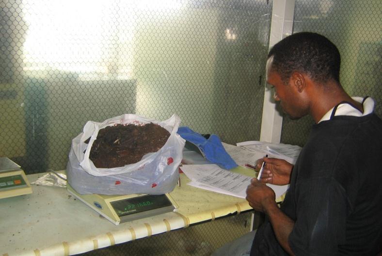


20 Preparation for Lab Analysis -Drying, Weighing and Homogenizing soils & litter


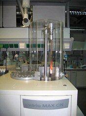

21 Laboratory measurement of soil carbon and other nutrients
22 SUMMARY Soil survey is essential to provide the basic information needed for efficient and effective land use planning or sustainable land use. Although there is increasing knowledge about soil, today s technology is still unable to fully delimit soil units on a specific landscape. Among the various land uses, forestry activities are one of the most important factors that produce changes in the environment. Understanding soil characteristics in their physical; chemical, mineralogical and biological aspects are essential to predict their behavior under changing environmental conditions from different uses.

23 Discussion Points Considerations For Planning an inventory 1. Do we know about the status soil carbon and other plant nutrients in PNG forest soils? 2. Does current knowledge guide sampling strategy for assessing soil nutrients of PNG? 3. What replication is required to cover expected soil carbon variation? Within sites Between Sites 4. Should we asses other nutrients apart from carbon? 5. Are surveyors, methods and equipment available? 6. Should we get outside supportcollaboration? 7. Costs and logistics 1. Survey Site and Objective 2. Information 3. Maps 4. Staff- team 5. Equipment 6. Laboratory 7. Logistics 8. Reports 9. Budget

24 The End Thank you